Free Downloads: Contour Map
Creating graphs of regular data and irregular data. Creating vertex, grid and surface model, Delaunay triangles, color Map, Contour plot, vector plot, 3D Contour plot, 4D scatter, 4D slice and 4D vector.
Category: Home & Education / Science
Publisher: GraphNow, License: Shareware, Price: USD $59.95, File Size: 2.6 MB
Platform: Unknown
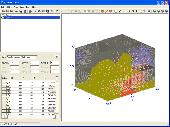
Real contour plots are created in Excel.
Real Contour plots are created in Excel. You can interact with the Contour plot just like any other Excel plot.
Contour Plot works with any Contour data. It accommodates rectangular data, nearly rectangular data, and irregular data. It includes a data generator for polynomials or any equation.
Category: Business & Finance / MS Office Addons
Publisher: Office Expander, License: Shareware, Price: USD $70.00, File Size: 696.1 KB
Platform: Windows
Filters is a image processing library designed to offer you: filter sobel, convolution, morphology, vectorization, blob, blur, histogram, segmentation, susan, threshold, texture, contrast, standard deviation, canny, Contour, distance Map, matrix, edge, rotation, correlation, gradient anisotropic. It works on Windows operating system.
Category: Software Development / Components & Libraries
Publisher: Eric Burgel, License: Freeware, Price: USD $0.00, File Size: 10.1 MB
Platform: Windows
The V option includes all capabilities of LI Contour, and adds the ability to calculate the volumetric difference between two surfaces. Output includes the total volumes of cut and fill, and a print out of the cut/fill amount at each data point.
Besides the ease-of-use and speed of LI Contour for general Contour mapping and surface modeling, the V option adds...
Category: Business & Finance / Applications
Publisher: A B Consulting Co., Inc., License: Shareware, Price: USD $299.00, File Size: 2.4 MB
Platform: Windows
Contour, the proven story development system developed by Emmy Award-nominated Jeffrey Alan Schechter, is designed to take your idea and turn it into a solid outline – the same kind of character-based structure used by many of the biggest blockbuster movies. Turn your idea into a solid outline like the character-based structure used by many blockbuster movies. Contour shows...
Category: Home & Education / Miscellaneous
Publisher: Mariner Software, License: Shareware, Price: USD $0.00, File Size: 9.2 MB
Platform: Windows
Terra Excess is land surveying and civil engineering CAD software developed to be extremely intuitive. Even by those without previous experience, Terra Excess will allow you to handle the following tasks in just a few minutes - GENERATING AND LABELING Contour LINES IN ORDER TO PRODUCE TOPOGRAPHIC PLANS AND MAPS: Terra Excess can generate Contour lines from topographic...
Category: Multimedia & Design / Graphics Viewers
Publisher: Terra Excess Software, License: Shareware, Price: USD $298.00, File Size: 46.0 MB
Platform: Windows
This definition was written to speed up the process of creating a Contour model while limiting the amount of waste generated during the fabrication of the physical model. An interface was developed within Grasshopper where all of the important settings can be controlled, allowing those who know little about grasshopper to still use the definition. A base surface is supplied to...
Category: Multimedia & Design / Multimedia App's
Publisher: LMNts, License: Freeware, Price: USD $0.00, File Size: 207.1 KB
Platform: Windows
Cool Flash Map Maker is a powerful Flash Map software for developing interactive flash mapping solutions and products for Real Estate, Spacial Statistics, Business Locator Applications, Vector USA Map,World Map, Germany Map,ASIA Map, Canada Map, Europe Map, Australia Map, Austria Map, Africa Map, UK Map, South...
Category: Multimedia & Design / Multimedia App's
Publisher: Go2Share, License: Shareware, Price: USD $29.95, File Size: 17.9 MB
Platform: Windows
Ezicontour is an integrated Windows based program designed for the needs of anyone that needs to produce Contour plans and / or simple maps. The program is as simple as possible to make this process easy and intuitive. However power and functionality has not been compromised. It will easily Contour 1 million points. The Ezicontour software uses the same routines as used by the...
Category: Home & Education / Miscellaneous
Publisher: Foresoft Pty Ltd, License: Shareware, Price: USD $95.00, File Size: 24.5 MB
Platform: Windows
Image Skill Outliner is a very useful plug-in.
Image Skill Outliner is a very useful plug-in. This plug-in works under some most popular commercial photo editing software like Adobe Photoshop 7, CS, CS2, CS3, Adobe Photoshop Elements 2, 3, 4, 5, 6, Coral Jasc Paint Shop Pro 7, 8, 9, Corel Paint Shop Pro (Photo) X, X1, X2, Corel Photo Paint 11, 12, Xara Xtreme, Microsoft Digital Image Suite 2006, Macromedia Fireworks 2004, 8, Ulead...
Category: Multimedia & Design / Multimedia App's
Publisher: ImageSkill, License: Freeware, Price: USD $0.00, File Size: 2.0 MB
Platform: Windows
Imports gridded data into Microsoft MapPoint, to produce attractive data maps that resemble Contour maps.
Can handle imperfect data, holes, re-gridding, etc. Can be used to import such attributes as pollution data, seismic hazard, geological information, customer/population distribution, etc.
Data can be interpolated to different grid spacings if required. Polygon optimization...
Category: Business & Finance / Applications
Publisher: Winwaed Software Technology, License: Shareware, Price: USD $75.00, File Size: 2.2 MB
Platform: Windows
GalilPVT is a software tool that is used to convert Galil Contour Data points to Galil Position Velocity and Time (PVT) profiles.Along with the ability to convert Contour Data to PVT profiles, the PVT software allows the user to graph position, velocity, acceleration and jerk for multiple axes and download the PVT data directly from the application to the controller.
Category: Audio / Rippers & Encoders
Publisher: Galil, License: Shareware, Price: USD $195.00, File Size: 3.4 MB
Platform: Windows
SecuriDesign is a set of macros for CorelDRAW and Corel DESIGNER that allow you to create various designs used frequently in security printing (on certificates, bank notes, documents, and so on). With SecuriDesign now it is very easy to create guilloche patterns right in CorelDRAW document.
SecuriDesign contains three basic modules:
- Contour Generator
- Pattern...
Category: Multimedia & Design / Image Editing
Publisher: Alex Vakulenko, License: Shareware, Price: USD $0.00, File Size: 313.0 KB
Platform: Windows
Remere's Map Editor is a map editor for the OpenTibia Project which was created by Remere.
Remere's Map Editor is a Map editor for the OpenTibia Project which was created by Remere.
Remere's Map Editor is a Map editor coded in C to be used with OpenTibia. It supports many advanced features such as autobordering and placing of composite objects. Runs under both Linux and Windows using wxWidgets and OpenGL.
Category: Games / Tools & Editors
Publisher: Remere, License: Shareware, Price: USD $0.00, File Size: 4.2 MB
Platform: Windows
 Freeware
An interactive Flash USA Map with all the features you need for your web site or project. This is the ideal solution for dealer maps, real-estate listings, or visualizing state statistics. Nearly every aspect of the Map is customizable. However, unlike competing products, our Map is very simple to install and edit. Just upload XML and SWF files and embed.
Category: Internet / Flash Tools
Publisher: http://www.flashusamap.com/trial/flashus, License: Freeware, Price: USD $0.00, File Size: 93.8 KB
Platform: Unknown
AutoDEM (aka as AutoMNT) is a freeware GIS software to create Digital Elevation Models (DEM) from scanned topographic maps for Windows.
Through different data layers (Map, contours, DEM, etc.), AutoDEM provides many tools for :
-Topographic Map analysis
-Contour lines extraction and reconstruction
-Contours to DEM interpolation and DEM analysis
...
Category: Multimedia & Design / Animation
Publisher: Joachim Pouderoux, License: Freeware, Price: USD $0.00, File Size: 27.6 MB
Platform: Windows
Map of Africa is one of the many maps created for GPS TrackMaker.
Map of Africa is one of the many maps created for GPS TrackMaker. You are able to download the installation package from the TrackMaker website. In order to preview the contents of this package, you need to install GPS TrackMaker.
Using the above mentioned application, you will be able to see the Map of Africa. Just click on the "Open Temporary...
Category: Home & Education / Miscellaneous
Publisher: Geo Studio Technology, License: Freeware, Price: USD $0.00, File Size: 18.3 MB
Platform: Windows
Shareware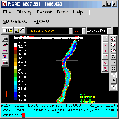
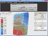
Simple, powerful and inexpensive CAD software for surveying. You can do triangulation, isolines, color-filled Contour maps, sections, intersections, volume and much more. You can process hundreds of thousands of points or triangles, even on less powerful PCs. Through its own CAD system (called RCAD), specialized for 3D and for a large number of entities, you can: -load and draw a file...
Category: Multimedia & Design / Graphics Viewers
Publisher: Rcad Software, License: Shareware, Price: USD $49.00, File Size: 1.0 MB
Platform: Windows
Shareware
AutoLISP source code can be run on AutoCAD or IntelliCAD (Bricscad, ProgeCAD, Cadopia, etc.), on any number of computers. There are 6 programs for: - "Triangulation" will generate triangular 3DFACE entities, on the convex hull of the set of points, - "Load XYZ and 4D files"; file types: x y z color, x y z scalar, x y z r g b, no. x y z code, - "B-spline control polygon and interpolated...
Category: Multimedia & Design / Graphics Viewers
Publisher: Rcad Software, License: Shareware, Price: USD $100.00, File Size: 1.4 MB
Platform: Windows
Program shows you an actual X3 sector-map, with detailed information about most in-game objects.
Program shows you an actual X3 sector-Map, with detailed information about most in-game objects. The Map is based on a log-file that is created with an in-game script (by Andrei[<>Ace]). If you just want to view the standard Map (or if you don’t have the game) the program will work with the included default Map, which was created with an English X3 game...
Category: Games / Misc. Games
Publisher: SUU Design, License: Freeware, Price: USD $0.00, File Size: 1.4 MB
Platform: Windows
New Zealand Map Reference Converter (NZMapConv) is software that LINZ provides to convert Map references between the old NZMS260 Map series and the new NZTopo50 Map series.NZMapConv is a Windows programme designed to convert individual coordinates entered manually.
Category: Multimedia & Design / Media Management
Publisher: Land Information New Zealand, License: Freeware, Price: USD $0.00, File Size: 2.4 MB
Platform: Windows
When the XMAP software is communicating with an XEDE via the comms cable each Map will show, at the top of the Map display, an RPM and load value (x and y axis for the Map) in real time. Also in each Map a yellow highlighted block will show the current position within the Map. Beside the real-time display on each Map are the undo and redo buttons which...
Category: Home & Education / Miscellaneous
Publisher: ChipTorque, License: Freeware, Price: USD $0.00, File Size: 1.7 MB
Platform: Windows
Sig Panama Has :
Digital maps of Panama, Digital Map of Panama-City, digital Map of Taboga, digital Map of Bocas del Toro, digital Map of Colon and Free Zone, digital Map of Contadora Island, digital Map of Coronado, Panama, Zona Libre, Map of Panama, Map of Panama City, Map of Colon, Map of Zona Libre, Map of...
Category: Internet / Misc. Plugins
Publisher: DP Imperial, LLC., License: Freeware, Price: USD $0.00, File Size: 44.9 MB
Platform: Windows
Freeware
Arm Map Explorer recreates all the functionalities of Google Maps on your desktop while expanding them with new extras. Map Explorer lets you locate and view any place on the planet using dynamic interactive maps. These maps are draggable, which means there is no need for you to click and wait for graphics to reload each time you want to view adjacent parts of a Map....
Category: Internet / Flash Tools
Publisher: ArmCode, License: Freeware, Price: USD $0.00, File Size: 5.5 MB
Platform: Windows
Time Zones Map is the flash world time Map featuring the time peculiarities of more then 50 cities all over the world. Its eye-catching but still pleasant design, varied functions and multiple application abilities combine everything the ultra-modern flash world time Map must have. You can put our Time Zone Map either on one of your website?s pages or put a banner,...
Category: Web Authoring / Flash Utilities
Publisher: USFlashMap.com, License: Shareware, Price: USD $249.00, File Size: 45.0 KB
Platform: Windows, Mac, Linux, Unix, MS-DOS, AS, 400