Free Downloads: Datasets
This program facilitates the process of edtiting, formatting and checking digital leveling observation data and creates abstracts, bok files, and VERTOBS Datasets for submission to the National Geodetic Survey (NGS). The program includes many built-in functions such as predicting temperature differences, refaction corrections, rod corrections and plotting. Also included are routines for...
Category: Business & Finance / Applications
Publisher: National Geodetic Survey, License: Freeware, Price: USD $0.00, File Size: 6.2 MB
Platform: Windows
TerraVisionTM is an Open Source distributed, interactive terrain visualization system developed by SRI International. It allows users to navigate, in real time, through a 3-D graphical representation of a real landscape created from elevation data and aerial images of that landscape. There are many terrain visualization tools on the market, but here are some of the features that make...
Category: Multimedia & Design / Graphics Viewers
Publisher: SRI International, License: Freeware, Price: USD $0.00, File Size: 2.1 MB
Platform: Windows
ET GeoTools is a set of tools for ArcGIS which purpose is to increase the editing productivity in ArcMap, give enhanced editing functionality to the ArcView users and enable them to create and maintain topologically correct Datasets.The tools are designed mainly for users with ArcView license, but will be asset for ArcEditor & ArcInfo license holders as well.
Category: Audio / Utilities & Plug-Ins
Publisher: ET SpatialTechniques, License: Shareware, Price: USD $245.00, File Size: 4.8 MB
Platform: Windows
DicomXBridge is a Dicom ocx/activex.
DicomXBridge is a Dicom ocx/activex.
Embed it in your application and it will be able to read, display and generate Dicom files.
It supportd a wide range of Dicom formats, including DICOMDIR files (read only) so your application can read Dicom CDs.
-Open large Datasets
-The ocx/activex can can open large Dicom Datasets: only the needed tags...
Category: Multimedia & Design / Multimedia App's
Publisher: Puntoexe software, License: Shareware, Price: USD $99.00, File Size: 682.6 KB
Platform: Windows
ET GeoTools is a set of tools for ArcGIS which purpose is to increase the editing productivity in ArcMap, give enhanced editing functionality to the ArcView users and enable them to create and maintain topologically correct Datasets.
- Identifying topology errors – draw nodes and duplicates for polyline layers, gaps and overlaps for polygon layers
-Offers usage of...
Category: Business & Finance / Business Finance
Publisher: ET SpatialTechniques, License: Shareware, Price: USD $245.00, File Size: 3.2 MB
Platform: Windows
 Commercial
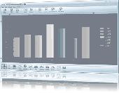
Charting tool for the rapid design of 13 different chart types, including bar, dot, horizontal bar, line, pie, donut, scatter, xy, area, histogram, error bar, bubble, gantt and volume charts. Additional features include 3D, multiple Datasets, gradients, transparency, unlimited annotations, and smoothing. Can be exported to files of types BMP, GIF, PNG, PS, PDF, EMF, JPG, SVG. Initially...
Category: Business & Finance / Applications
Publisher: Creative-PC, License: Commercial, Price: USD $49.00, File Size: 7.6 MB
Platform: Windows
Freeware
The Database editor allows you to work with several databases simultaneously. Easy way for exports and imports your Datasets to popular formats. Convenient connection manager provide the rapid switching between databases. Support databases: Any. Oracle, DB2, MS SQL SERVER, MY SQL, Access etc Features: * Object Browser * Import from csv,excel * Export to...
Category: Software Development / Databases & Networks
Publisher: Acid, License: Freeware, Price: USD $0.00, File Size: 1.6 MB
Platform: Windows
Commercial
NextGeneration is a software development tool that saves you time and effort by quickly building database-driven applications. N-Tier solution templates for C# .NET, VB.NET and SQL get your project started rapidly. NextGeneration supports SQL Server and Microsoft Access databases. Generate stored procedures, data access objects, business service classes, Datasets and an ASP.NET web...
Category: Software Development / IDEs & Coding Utilities
Publisher: RAD Software, License: Commercial, Price: USD $279.00, File Size: 1.2 MB
Platform: Windows
InfoScope allows users to easily analyze, compare, query, and explore large or complex Datasets . InfoScope is a highly interactive visualization tool that shows the big picture by providing an overview of the essential relationships, encourages the explorative discovery of in the overall context, and supports our way of thinking and working by taking advantage of the human perceptual...
Category: Business & Finance
Publisher: Macrofocus GmbH, License: Freeware, Price: USD $0.00, File Size: 18.7 MB
Platform: Windows, Mac, Linux, Unix, Java
This Access-like Windows Forms data navigation control is built to work with Datasets, views, collections and every object that implements the IList interface. It works in the Microsoft .NET Framework and is best used in the Microsoft VS.NET developing environment. It can be used with all the VS.NET compatible languages, foremost of course VB.NET and C#. It is built so that a novice user...
Category: Software Development / Components & Libraries
Publisher: dtrt ag, License: Commercial, Price: USD $31.30, File Size: 4.2 MB
Platform: Windows
T2K Pro integrates the rich world of GIS Datasets and transfers your Geographic information data into Google earth. T2K Pro handles rich data types and access large volumes of geographic data stored in files and databases; T2K PRO handles raster (imagery), Vector Map data and GPS Tracks/ Waypoints/ Routes. Tiles2kml Pro provides a complete suite of conversion tools to easily visualize...
Category: Multimedia & Design / Authoring Tools
Publisher: Tiles2kml, License: Demo, Price: USD $90.00, File Size: 20.9 MB
Platform: Windows
Shareware
Microsoft MapPoint add-in that performs cluster analysis on MapPoint Datasets. Cluster results can be drawn as map annotation (centroid pushpins and/or cluster boundary shapes) and exported to Microsoft Excel. MPCluster works with most MapPoint dataset types, including pushpins and shaded areas maps. Various parameters can be used to restrict the minimum or maximum size of clusters, as...
Category: Business & Finance / Business Finance
Publisher: Winwaed Software Technology LLC, License: Shareware, Price: USD $100.00, File Size: 4.8 MB
Platform: Windows
Shareware
NovoSpark Visualizer is an advanced, powerful and feature rich visualization program that enables qualitative analysis of multi-dimensional data on a graphical image. The product comes with a variety of image viewing options that helps you get the most representative view of your data. With NovoSpark Visualizer you will be able to visually compare individual observations and entire...
Category: Business & Finance / Applications
Publisher: DEK Software International, License: Shareware, Price: USD $499.00, File Size: 27.9 MB
Platform: Windows
Markov Random Field Surface Reconstruction (MRFSurface) is a surface reconstruction and remeshing method. It has been tested on modestly sized Datasets and the results are comparable to current state-of-the-art algorithms. In particular, it has been shown to be well suited for hole filling in surface scans of human faces. Currently, a compiled version is available for free use - or more...
Category: Multimedia & Design / Multimedia App's
Publisher: Rasmus R. Paulsen, License: Freeware, Price: USD $0.00, File Size: 8.2 MB
Platform: Windows
Gnuplot.py is a Python package that interfaces to gnuplot, the popular open-source plotting program. It allows you to use gnuplot from within Python to plot arrays of data from memory, data files, or mathematical functions. If you use Python to perform computations or as 'glue' for numerical programs, you can use this package to plot data on the fly as they are computed. And the...
Category: Multimedia & Design / Multimedia App's
Publisher: pythonxy.com, License: Freeware, Price: USD $0.00, File Size: 193.3 KB
Platform: Windows
Osprey is a software platform for visualization and manipulation of complex interaction networks.
Osprey is a software platform for visualization and manipulation of complex interaction networks.
Osprey builds data-rich graphical representations that are color-coded for gene function and experimental interaction data. Mouse-over functions allow rapid elaboration and organization of network diagrams in a spoke model format.Osprey also allows for user-defined large-scale...
Category: Internet / Misc. Plugins
Publisher: Bobby-Joe Breitkreutz, Chris Stark, License: Freeware, Price: USD $0.00, File Size: 21.4 MB
Platform: Windows
FugroViewer is a robust, easy-to-use software designed to help users make the most of their geospatial data. Developed by Fugro Geospatial Services, FugroViewer is designed for use with various types of raster- and vector-based geospatial Datasets, including data from photogrammetric, LiDAR, and IFSAR sources.
Category: Home & Education / Miscellaneous
Publisher: Fugro Geospatial Services, License: Freeware, Price: USD $0.00, File Size: 2.8 MB
Platform: Windows
World-leading traffic analysis software compatible with all MetroCount traffic survey products.
World-leading traffic analysis software compatible with all MetroCount traffic survey products. Uses MetroCount’s encrypted Datasets to provide a comprehensive array of reports, including vehicle speed, classification, time, headway, separation, and more.
Many text-based and graphical reports available. May be delivered in other languages. Compatible with Microsoft...
Category: Home & Education / Miscellaneous
Publisher: MetroCount, License: Shareware, Price: USD $0.00, File Size: 0
Platform: Windows
This software, written by Mark O.
This software, written by Mark O. Hill & Petr Smilauer (with contribution of Cajo Ter Braak and John Birks), is available free of charge for any non-commercial or commercial purposes and can be installed and used even if you do not have a license for Canoco for Windows. It implements divisive classification method named TWINSPAN (Two-way Indicator Species Analysis) and analyses...
Category: Utilities / Misc. Utilities
Publisher: Petr Smilauer, License: Freeware, Price: USD $0.00, File Size: 1.1 MB
Platform: Windows
Shareware
SQLReplicator for MySQL 5.1+ s a set of tools for replicating databases running under MySQL server v. 5.1 and later. This software performs data replication in the real-time mode between databases on local or remote servers. SQLReplicator for MySQL 5.1+ makes a valuable addition to the functionality of a standard MySQL database server. This tool allows monitoring data modifications and...
Category: Business & Finance / Database Management
Publisher: Desktop Software, License: Shareware, Price: USD $300.00, File Size: 6.0 MB
Platform: Windows
kogeo seismic toolkit is a free and open toolkit for 2d/3d seismic data analysis.
kogeo seismic toolkit is a free and open toolkit for 2d/3d seismic data analysis.
The program features: import/export/transform 2d/3d SEG-Y, SU or even bitmap data (images) in various sub-formats. Also features data editing is possible in many ways using kogeo, from simple filters to multi-trace or neural network attributes.
Moreover you can organize data in projects, to have them...
Category: Utilities / Misc. Utilities
Publisher: Philipp Konerding, License: Shareware, Price: USD $0.00, File Size: 24.6 MB
Platform: Windows
Project Trident: A Scientific Workflow Workbench is a set of tools based on the Windows Workflow Foundation that addresses scientists’ need for a flexible, powerful way to analyze large, diverse Datasets. It includes graphical tools for creating, running, managing, and sharing workflows.
- Trident Workflow Composer provides graphical tools for creating workflows.
...
Category: Software Development / Misc. Programming
Publisher: Microsoft, License: Freeware, Price: USD $0.00, File Size: 13.9 MB
Platform: Windows
GISConnect adds several menus and toolbars to your AutoCAD application, so you can use native AutoCAD commands to create, edit and visualize GIS features in their native format.
Adding data - Choose Datasets based on spatial coordinates, using a window, or using a query builder.
Category: Multimedia & Design / Image Editing
Publisher: Bentley Systems, License: Demo, Price: USD $0.00, File Size: 250.0 MB
Platform: Windows
Climate charts with wave height, direction and period.
Climate charts with wave height, direction and period. Climate is by definition the synthesis of weather conditions in a given area, characterized by long-term statistics (mean values, standard deviations, etc.) of the meteorological elements in that area.
According to the World Meteorological Organization (WMO) it should preferably be based on 30 years of data. To conform with...
Category: Business & Finance / Applications
Publisher: KNMI, License: Freeware, Price: USD $0.00, File Size: 17.7 MB
Platform: Windows
EditTools for Microsoft Word benefits both editors and publishers.
EditTools for Microsoft Word benefits both editors and publishers. EditTools helps a good editor be a better editor by increasing consistency and accuracy while speeding up the editing process. Publishers benefit from the increased speed, consistency, and accuracy that EditTools brings to a project by the reduction in prepress costs and time. An additional benefit for both editors and...
Category: Utilities / Misc. Utilities
Publisher: wordsnSync, License: Shareware, Price: USD $0.00, File Size: 0
Platform: Windows