Free Downloads: Digital Elevation Model Free Download
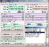
Introducing you AEC Terrain interface which is designed to simplify terrain management and 3D-modeling. AEC Terrain creates Digital Elevation Model from multiple input point files on AutoCAD graphic editor. All purpose multi-level pads, road alignments, mining applications and airfields can be generated on the terrain on different layers with different slope parameters for...
Category: Business & Finance / Project Management
Publisher: AEC Logic Private Limited, License: Shareware, Price: USD $750.00, File Size: 16.3 MB
Platform: Windows
Do you feel that the standard tracks (Speed, Elevation, Heart rate, .
Do you feel that the standard tracks (Speed, Elevation, Heart rate, ...) are sometimes not enough?
This plugin lets you add your own tracks to activities: calculated power vs. measured power, Elevation before applying an Elevation correction, power from a second power meter (e.g. an iBike), ...
You can as well use it to "stow away" tracks before...
Category: Audio / Utilities & Plug-Ins
Publisher: Old Man Biking's SportTracks Plugins, License: Shareware, Price: USD $6.89, File Size: 1004.2 KB
Platform: Windows

Importation/Exportation: Import/export trails to gpx file. Unlimited number of trails, and TrackPoints. Export to gpx, Excel, PDF, XPS and KML/KMZ. Data table: Very flexible data table that allows sorting by columns, with inheritance of data, attributes, etc. Presentation on map: View on map in accordance with the active trail, which comes from providers of maps, as in 'Satellite' mode...
Category: Home & Education / Miscellaneous
Publisher: Aplicaciones Topográficas S.L., License: Freeware, Price: USD $0.00, File Size: 27.0 MB
Platform: Windows
Geographic databases management and exploitation, attribute-based and spatial queries, several join types, several classification methods, thematic cartography, statistics and geo-statistics, spatial analysis, interpolations, Digital Elevation models, remote-sensing and image processing, simulation, operational research, interactive metric measurements
Category: Home & Education / Miscellaneous
Publisher: IRD, License: Freeware, Price: USD $0.00, File Size: 14.2 MB
Platform: Windows
Overview of Purpose:What is SpriteForge?
Overview of Purpose:What is SpriteForge? SpriteForge is essentialy a tool for creating large numbers of 2D sprites from 3D models. You can 'photoraph' your Model's animation frames (or simply it's static profile) from several different camera angles in just a few easy steps. Primarily designed for creating game sprites, spriteForge is also great for making 3D website graphics (ie...
Category: Multimedia & Design / Image Editing
Publisher: D-Grafix, License: Shareware, Price: USD $16.00, File Size: 1.7 MB
Platform: Windows
AutoDEM (aka as AutoMNT) is a freeware GIS software to create Digital Elevation Models (DEM) from scanned topographic maps for Windows.
Through different data layers (map, contours, DEM, etc.), AutoDEM provides many tools for :
-Topographic map analysis
-Contour lines extraction and reconstruction
-Contours to DEM interpolation and DEM analysis
-DEM...
Category: Multimedia & Design / Animation
Publisher: Joachim Pouderoux, License: Freeware, Price: USD $0.00, File Size: 27.6 MB
Platform: Windows
SatCalc is a Free software which calculates Azimuth and Elevation for geostationary satellites used for television broadcast.
Features include the calculation of the LNB skew and calculation of sun outage which occurs in spring and fall. The calculated data is presented graphically and can also be printed out and exported to HTML or CSV.
A list of...
Category: Business & Finance / Applications
Publisher: Martin Kirisits, License: Freeware, Price: USD $0.00, File Size: 1.6 MB
Platform: Windows
Overview of Purpose: What is SpriteForge? SpriteForge is essentialy a tool for creating large numbers of 2D sprites from 3D models. You can 'photoraph' your Model's animation frames (or simply it's static profile) from several different camera angles in just a few easy steps. Primarily designed for creating game sprites, spriteForge is also great for making 3D website graphics (ie...
Category: Multimedia & Design
Publisher: D-Grafix, License: Shareware, Price: USD $16.00, File Size: 1.7 MB
Platform: Windows
ArBa3d is a 3D modeling software that allows to create a 3D model from a set of digital photos.
ArBa3d is a 3D modeling software that allows to create a 3D Model from a set of Digital photos. The tool takes as input a set of photos taken from different viewpoints. It tesselates the vertices and constraint edges from the user input to produce a 3D Model that can then be exported to different 3D formats (vrml, obj, x, flt, x3d, kml). The 3D models can also be displayed...
Category: Multimedia & Design / Image Editing
Publisher: ArBa3d.com, License: Shareware, Price: USD $0.00, File Size: 5.3 MB
Platform: Windows
The Paroscientific Digiquartz Data Download is an easy and useful Download program
developed to help you to Download logged data from Model 765 or Model MET4/MET4A.
After Download you can find it stored in a text document as a comma delimited text file.
Category: Business & Finance / Business Finance
Publisher: Paroscientific, Inc., License: Freeware, Price: USD $0.00, File Size: 3.9 MB
Platform: Windows
Create the GeoDatabase for the entire world. This program create the geographical location Latitude, Longitude, and Altitude (Elevation) for every city, village, region, state, county in the World. The program crawls the data from the website www.heavens-above.com which collect data from US Geological Survey for the USA (and dependencies) and The National Imaging and Mapping Agency for...
Category: Software Development
Publisher: Mewsoft, License: Freeware, Price: USD $0.00, File Size: 1.1 MB
Platform: Windows
 Data Only
IP2Location IP-COUNTRY-REGION-CITY-LATITUDE-LONGITUDE-ZIPCODE-TIMEZONE-ISP-DOMAIN-NETSPEED-AREACODE-WEATHER-MOBILE-Elevation-USAGETYPE is commercial IP geolocation database that translates IP address to country, region, city, latitude, longitude, zip code, time zone, ISP name, domain name, net speed, area code, IDD code, weather, mobile, Elevation and usage type. Developers use...
Category: Internet / Tools & Utilities
Publisher: IP2Location.com, License: Data Only, Price: USD $3399.00, File Size: 94.5 MB
Platform: Windows
In the Dynamic Link Library GeoDLL geodesic functions like coordinate transformation, datum changes, meridian strip changes, user defined coordinate and reference systems, distance calculation, maps functions, Digital Elevation Models and more geodesic functions are contained to bind them into own applications. WINDOWS operating system allows building of function libraries...
Category: Software Development
Publisher: Killet Softwareentwicklung GbR, License: Shareware, Price: USD $290.00, File Size: 999.9 KB
Platform: Windows
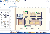
Floor Plan Maker is perfect not only for professional-looking floor plan, office layout, home plan, seating plan, but also garden design, fire and emergency plan, HVAC, Elevation diagram... and that is just the beginning! Floor Plan Maker is inclusive software supporting to produce more than 13 types of floor plans. It can be applied to design floor plan, home plan, office layout,...
Category: Multimedia & Design / Graphics Viewers
Publisher: EdrawSoft, License: Shareware, Price: USD $99.00, File Size: 61.7 MB
Platform: Windows
In the Dynamic Link Library GeoDLL geodesic functions like coordinate transformation, datum changes, meridian strip changes, user defined coordinate and reference systems, distance calculation, maps functions, Digital Elevation Models and more geodesic functions are contained to bind them into own applications. WINDOWS operating system allows building of function libraries...
Category: Software Development
Publisher: Killet Softwareentwicklung GbR, License: Shareware, Price: USD $290.00, File Size: 999.9 KB
Platform: Windows
The Atomic Memory Model is a powerful methodology which handles memory in a consistent, elegant, simple and highly effective way, greatly increasing the quality of code and speed of development. By abstracting the memory and representing it as an encapsulated entity, one can eliminate all of the issues arising around using memory in a Digital computer system and make them...
Category: Software Development / Components & Libraries
Publisher: MBBSoftware, License: Data Only, Price: USD $0.00, File Size: 1.3 MB
Platform: Windows, Mac, Linux,

Top 10 nikon Digital cameras screen saver helps you find best Model for your needs. This software helps you select which nikon Digital camera to buy. You must know that all nikon Digital cameras before buy one from all. www.discountnikoncameras.com software useful for people who interesting purchase nikon camera and want get more information about all popular models...
Category: Utilities
Publisher: Discountnikoncameras, License: Freeware, Price: USD $0.00, File Size: 5.2 MB
Platform: Windows

Do you know how is difficult to become the profession model?
Do you know how is difficult to become the profession Model? You should have refined taste and design talent to choose right colors and accessories for every suite! Test your skills and taste in the new fashion dress up game Fashion Show 2010: Dress up Beginner Model! Help the beginner Model to choose the fashionable dress, beautiful shoes and suiting accessories to look...
Category: Games / Simulations
Publisher: doublegames.com, License: Freeware, Price: USD $0.00, File Size: 4.9 MB
Platform: Windows
Potent is a Windows application that provides a highly interactive framework for 3-D modelling of magnetic and gravity data.
This example uses one of Geosoft's Oasis montaj sample datasets. The top left window shows the entire TMI dataset as a grid. The bottom left window shows the subset of data around the two anomalies of interest. The top right window shows an ENE section...
Category: Multimedia & Design / Multimedia App's
Publisher: Geophysical Software Solutions Pty. Ltd., License: Shareware, Price: USD $750.00, File Size: 8.5 MB
Platform: Windows
CRunGEM is a program to allow people with little GEMPACK experience to run a static CGE model.
CRunGEM is a program to allow people with little GEMPACK experience to run a static CGE Model. It is designed for those who wish to design and perform simulations without changing the Model's equations or database. It would be suitable for classroom use, or perhaps to package a Model for use by economists who are not GEMPACK experts. You can Download and run...
Category: Software Development / Misc. Programming
Publisher: GEMPACK Software, License: Freeware, Price: USD $0.00, File Size: 15.1 MB
Platform: Windows
Success of failure of the software projects greatly depends on right chose software development lifecycle Model. Many software developers make the big mistake of using only one software development lifecycle Model (SDLCM) for all software projects. Our tool helps avoid this problem. Lifecycle Selector is a absolutely Free, very useful and easy to use software engineering...
Category: Business & Finance
Publisher: SoftDevTeam, License: Freeware, Price: USD $0.00, File Size: 341.8 KB
Platform: Windows
Shareware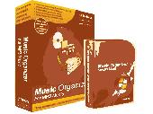
Digital Music Organizer - Download best Digital music organizer to see how easy it became to organize music with the help of high-end Digital music organizer software. Designed for home and professional use Digital music organizer is available for everybody. Even a housewife or a kid can easily use high-end Digital music organizer tool to organize music...
Category: Audio / MP3 Search Tools
Publisher: Music Organizer, Ltd., License: Shareware, Price: USD $39.95, File Size: 12.9 MB
Platform: Windows
Solibri Model Viewer is Free software built for viewing Open Standard IFC files and Solibri Model Checker files. Solibri Model Viewer brings BIM files from all IFC compatible software products available for you in a single environment.
With Solibri Model Viewer the analysis results and presentations can be shared with the whole design team, owner...
Category: Multimedia & Design / Graphics Viewers
Publisher: Solibri, inc., License: Freeware, Price: USD $0.00, File Size: 23.1 MB
Platform: Windows
Bird Model 5000-EX Digital Power Meter is very easy to operate.
Bird Model 5000-EX Digital Power Meter is very easy to operate.Once a sensor is connected, turn the DPM on and take a reading. Additional commands are available,
depending on the sensor used.Use the speed keys to set the measurement and measurement units. Refer to the sections following for instructions specific to each sensor.
Category: Business & Finance / Business Finance
Publisher: Bird Electronics, License: Freeware, Price: USD $0.00, File Size: 6.5 MB
Platform: Windows
LocalConnect is the included application for converting and uploading Vectors, Images, Maps, and Elevation to GISRoam.
LocalConnect includes tools to automatically convert your source data to GISRoam formats and projections in the following formats:
* Elevation in the form of DTED, DEM, ARCGrid, GEOTIFF, SRTM, XYZ Grid, and BIL.
* Imagery in the form of MRsid,...
Category: Internet / File Sharing
Publisher: Cogent3D, License: Freeware, Price: USD $0.00, File Size: 26.4 MB
Platform: Windows