Free Downloads: Geo Location
Successful on-site measurement, whether checking, staking or using machine control systems depends upon the preparation and integrity of the design data. The software application used to prepare design data for on-site measurement and machine control systems must maintain this integrity whether design data comes in the form of a paper plan or a complete 3D digital model. SBG Geo...
Category: Multimedia & Design / Image Editing
Publisher: SBG AB, License: Demo, Price: USD $0.00, File Size: 50.0 MB
Platform: Windows
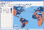
Now you can trace your network activity on world map.Geo Spider helps you to trace, identify and monitor your network activity on world map.You can trace any website or IP address. Whois reports give to you more info about site, host, domain, ip address...
Category: Internet / Tools & Utilities
Publisher: Oreware.com, License: Shareware, Price: USD $20.00, File Size: 10.4 MB
Platform: Unknown
Geo estimator it is a program which measures the roof area and makes an graphic schematics of the roof. With it you can measure any home roof, from anywhere without even going there. You need maps for it and you will find them on the homepage of the application but you have to pay for them.
Category: Business & Finance / Business Finance
Publisher: Thornberry Consulting, LLC, License: Shareware, Price: USD $0.00, File Size: 0
Platform: Windows
Geo-SLOPE GeoBorrow
License borrowing allows a company that has purchased GeoStudio 2007 network licenses to have an end-user ‘check out’ a license for use while disconnected from the corporate network. This feature enables you to temporarily make use of a network license in a standalone capacity. Once a license is borrowed, the license is removed from the pool,...
Category: Business & Finance / Database Management
Publisher: GEO-SLOPE International Ltd., License: Freeware, Price: USD $0.00, File Size: 1.6 MB
Platform: Windows
GeoSetter is a freeware tool for Windows (XP or higher) for showing and changing Geo data and other metadata (IPTC/XMP/Exif) of image files (e.g. images taken by digital cameras).
fEATURES:
- Reads and writes the formats JPEG and TIFF as well as camera RAW formats DNG (Adobe), CRW, CR2 and THM (Canon), NEF and NRW (Nikon), MRW (Konica Minolta), PEF (Pentax), ORF (Olympus),...
Category: Multimedia & Design / Media Management
Publisher: Friedemann Schmidt, License: Freeware, Price: USD $0.00, File Size: 18.8 MB
Platform: Windows
RCounter Geo is a system for gathering and reviewing statistics, analysis of web-site attendance (as well as separate web-pages). RCounter 2.0 Geo is the most powerful tool from the RCounter family. It has all features of RCounter light, plus Geographical statistics and a unique utility, which can easily export information from RCounter database in Word, Excel, or dispatch reports...
Category: Internet / Tools & Utilities
Publisher: NooLab, License: Shareware, Price: USD $125.00, File Size: 1.6 MB
Platform: Windows, Linux,
GTrek-IV, is a digital Image Viewer and Geo Tagging tool!
GTrek-IV, is a digital Image Viewer and Geo Tagging tool! Any picture taken by you can be tagged by the program to locate it with Google Earth. Of course, the place in the picture must be visible on Google Earth. GeoTagged data is stored in textural form as geographical coordinates. The program can be used to tag it as well as to view the image along with the Google Earth photo.
Category: Multimedia & Design / Multimedia App's
Publisher: GTrek Ltd., License: Shareware, Price: USD $11.30, File Size: 5.8 MB
Platform: Windows
Today, businesses are going online.
Today, businesses are going online. Effective web marketing starts with the thorough analysis of your potential customers' browsing habits, web site effectiveness monitoring and Geo-targeting.
Raw web server logs offer a lot of valuable marketing information. The only question is what tool we use to extract this precious data from meaningless lines of alphanumeric characters,...
Category: Web Authoring / Web Design Utilities
Publisher: Altstone Software, License: Shareware, Price: USD $49.95, File Size: 12.2 MB
Platform: Windows
Create GPS enabled Geo maps directly on the background of aereal photos and road maps from the internet. Import geodata from Google-Earth, OpenStreetMap, GPS tracks and GPS logger. Map editor , manually digitizing. Specifical graphical objects (borderlines, borderareas) to guarantee exact same borders of neighbour areas..Screen calibration for true to display on the screnn.
Category: Multimedia & Design / Digital Media Editors
Publisher: GPSur Dr. Erhard Regener, License: Shareware, Price: USD $65.00, File Size: 6.4 MB
Platform: Windows
The MapSys Cadastral GIS offers specialized functionality for each stage of processing including the digital map creation, plotting cadastral and topographical plans, generating and combining Geo-referenced data in order to obtain a validated relational Geo-database. This can be used in MapSys or in other GIS programs or database application.
Category: Home & Education / Teaching Tools
Publisher: GEOTOP, License: Freeware, Price: USD $0.00, File Size: 143.9 MB
Platform: Windows

You can think of the Tometa WhereIs service as the Internet's telephone directory. It gives you information on the geographical Location of an IP address based on Internet infrastructure information With a free SDK, email support and code examples in almost any language WhereIs easily provides information on the geographic Location of Internet visitors and IP addresses. Cutting...
Category: Internet
Publisher: Tometa Software, Inc., License: Shareware, Price: USD $9.95, File Size: 2.2 MB
Platform: Windows, Mac, Linux, Palm,
World Heroes is a fighting game series created by ADK.
World Heroes is a fighting game series created by ADK.Originally released for the Neo Geo. Also ported onto Sega Genesis on August 16, 1994 and SNES in September of 1993 by Sega Midwest Development Division/ Sega Midwest Studio and Sunsoft, respectively. The Neo-Geo version has been released through Nintendo's Virtual Console service and in SNK Arcade Classics Vol. 1 as a...
Category: Games / Misc. Games
Publisher: Sega, License: Freeware, Price: USD $0.00, File Size: 1.8 MB
Platform: Windows
GEOCatalog is an application to allow easy management of the files created by the authoring programs that comprise the Geo Software Suite.
GEOCatalog finds and collates all ODF files within any defined local or network path(s), and displays them within a customizable 'spread-sheet' format.
Category: Utilities / Misc. Utilities
Publisher: SDC Software Ltd., License: Freeware, Price: USD $0.00, File Size: 15.3 MB
Platform: Windows
RMS provides the industry's smoothest and most powerful geo-modelling workflow.
RMS provides the industry's smoothest and most powerful Geo-modelling workflow.
Reservoir models are arguably the most important decision-making tool that operators have at their disposal in the oil and gas industry today.
RMS 2010 brings you a high quality and easy-to-use reservoir modelling suite with major improvements across the entire workflow, with a wide-ranging...
Category: Business & Finance / MS Office Addons
Publisher: Roxar, License: Shareware, Price: USD $235.00, File Size: 13.7 MB
Platform: Windows
USA Real Estate Map Pro is a premium class software for mapping: real estate properties, contact listings, offices and other Geo spatial data. Interactive Real Estate map is rather simple to integrate with database listings: both to specify the states and counties that should be active on map, and pass the selected county name or ID back, for further use. Among the benefits of US Real...
Category: Business & Finance / Database Management
Publisher: USFlashMap.com, License: Shareware, Price: USD $399.00, File Size: 10.4 MB
Platform: Windows, Mac, Linux, Unix, MS-DOS, AS, 400
AVIC FEEDS creates a link between your Pioneer AVIC Navigation system and your PC.
AVIC FEEDS creates a link between your Pioneer AVIC Navigation system and your PC.You can use AVIC FEEDS to view and edit data from your AVIC system.It allows you to bring content from your PC and the Internet to your AVIC system, import a Location from a Geo-Tagged Photo from Flickr and much more.
Category: Internet / Misc. Plugins
Publisher: PIONEER CORPORATION, License: Freeware, Price: USD $0.00, File Size: 12.8 MB
Platform: Windows
The AMGtime app allows employers to track their employees movements on the go and at remote locations, with notifications for every transaction. Managers Can: - Check the Status Board on their smartphone for real-time data on employee Location, punches, and time worked - View absence/presence summaries - Ensure constant communication with their mobile workforce Employees Can:...
Category: Business & Finance / Applications
Publisher: AMG Employee Management, License: Freeware, Price: USD $0.00, File Size: 34.0 MB
Platform:
Panoply is a Java application which enables the user to plot raster images of Geo-gridded data from netCDF datasets. Panoply is an utility that enable user to plot raster image. Depending on the data, it can draw global longitude-latitude images or pole-t
Category: Multimedia & Design / Illustration
Publisher: giss.nasa.gov, License: Freeware, Price: USD $0.00, File Size: 9.4 MB
Platform: Windows, Mac, 2K, 2K3, Vista
Building on top of OSSIM and OpenSceneGraph capabilities, ossimPlanet is a rapidly evolving project for accurate, high performance, 3D Geo-spatial visualization.
It automatically intersects with DTED and/or SRTM elevation trees for topography and handles a wide range of commercial and government file formats natively.
Additionally, remote layers can be...
Category: Multimedia & Design / Multimedia App's
Publisher: OSSIM, License: Shareware, Price: USD $0.00, File Size: 995.4 MB
Platform: Windows
The database tables contains geodata of the Federal Republic of Germany with Geo referenced towns, municipalities, town quarters and other administrative units, postal codes, telephone preselections, nature areas, landscapes, climatic zones and official topographical cartographies. The data contain coordinates for navigation and Geo-coding, proximity searches and distance...
Category: Business & Finance / Database Management
Publisher: Killet GeoSoftware Ing.-GbR, License: Data Only, Price: USD $175.00, EUR150, File Size: 3.2 MB
Platform: Windows
With this program, you can store GPS data and real address information for every picture.
With this program, you can store GPS data and real address information for every picture. Using photoGPS, you can capture Geo-data on site, automatically combine GPS and Location data with pictures (using included Matching software), search, sort and organise all pictures acc. to country, city, street (using included Organizer software).
Category: Multimedia & Design / Multimedia App's
Publisher: JOBO, License: Freeware, Price: USD $0.00, File Size: 46.4 MB
Platform: Windows
 Freeware
There is no good rule of thumb to determine the geolocation of Internet IP addresses. While some IP blocks tend to belong to certain countries, other IP blocks are distributed in an almost anarchic fashion. Moreover, the IP distribution is not static but in a continuous mutation with new additions, reallocations and deletions. AWIPLOC allows you to resolve IPs to Country, City, Region and...
Category: Internet / Internet Phone and Teleconferencing
Publisher: AtelierWeb Software, License: Freeware, Price: USD $0.00, File Size: 2.9 MB
Platform: Windows
Shareware
Are you looking for a strong Location changer? Just try imyPass iPhone Location Changer. It wont let you down. With it, you can modify and set fake Location for iOS devices conveniently. Key Functions: 1. Modify and set fake GPS Location. If you dont want others to know your actual Location and expose yourself, you can use imyPass iPhone...
Category: Audio / Audio Players
Publisher: imyPass Studio, License: Shareware, Price: USD $9.90, File Size: 72.5 MB
Platform: Mac
The Orbit Visualization Tool (OVT) is a software for visualization of satellite orbits in the Earth's magnetic field. The program can display satellite orbits in five coordinate systems (GEI, Geo, GSM, SMC, GSE), satellite footprints projected on the Earth's surface and shown in either geographic (Geo) or geomagnetic (SMC) coordinates. In addition to satellite orbits the...
Category: Home & Education / Astrology & Numerology
Publisher: OVT Team, License: Freeware, Price: USD $0.00, File Size: 0
Platform: Windows
Instant QR Codes is able to generate QR codes for web url addresses, email, Geo locations, phone numbers, contact cards, me-cards, wifi configuration and even Android Marketplace. The best part is that the program does not need a active Internet connection, it is totally self-contained.
Category: Utilities / Misc. Utilities
Publisher: JettDigitals, License: Freeware, Price: USD $0.00, File Size: 2.5 MB
Platform: Windows