Free Downloads: Geographic Diagram Maker
A Circuit Diagram Maker - Circuit Diagram enables you to make electronic circuit diagrams and allows them to be exported as images. Ideal for use in coursework, you no longer have to use image editing programs to paste components together.Its a very good program.
Category: Multimedia & Design / Multimedia App's
Publisher: Circuit Diagram, License: Freeware, Price: USD $0.00, File Size: 343.0 KB
Platform: Windows
UML .FRI is visual Diagram editor. It's aimed towards Diagram types commonly used by people involved in IT.
Main Features:
Currently, it's possible to create and edit:
- UML class Diagram
- UML object Diagram
- UML activity Diagram
- UML use case Diagram
...
Category: Multimedia & Design / Digital Media Editors
Publisher: Faculty of Management Science and Informatics, University of Zilina, License: Freeware, Price: USD $0.00, File Size: 1.1 MB
Platform: Windows
The UML stencil for Microsoft Visio supports complete UML, i.
The UML stencil for Microsoft Visio supports complete UML, i.e. UML use case Diagram, class Diagram, package Diagram, object Diagram, composite structure Diagram, interaction Diagram, sequence Diagram, communication Diagram, interaction overview Diagram, activity Diagram, state machine Diagram, component...
Category: Business & Finance / MS Office Addons
Publisher: Pavel Hruby, License: Freeware, Price: USD $0.00, File Size: 513.7 KB
Platform: Windows
DIVA-GIS is a free computer program for mapping and Geographic data analysis (a Geographic information system (GIS). With DIVA-GIS you can make maps of the world, or of a very small area, using, for example, state boundaries, rivers, a satellite image, and the locations of sites where an animal species was observed.
Category: Business & Finance / Applications
Publisher: diva-gis, License: Freeware, Price: USD $0.00, File Size: 3.8 MB
Platform: Windows
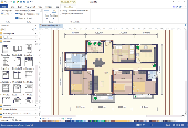
Floor Plan Maker is perfect not only for professional-looking floor plan, office layout, home plan, seating plan, but also garden design, fire and emergency plan, HVAC, elevation Diagram... and that is just the beginning! Floor Plan Maker is inclusive software supporting to produce more than 13 types of floor plans. It can be applied to design floor plan, home plan,...
Category: Multimedia & Design / Graphics Viewers
Publisher: EdrawSoft, License: Shareware, Price: USD $99.00, File Size: 61.7 MB
Platform: Windows
Diagram Ring is an award-winning advanced diagram editor.
Diagram Ring is an award-winning advanced Diagram editor. It supports lots of Diagram types like Flowcharts, Class Diagrams, DFDs, ERDs, Pie charts, Bar charts and etc.
It has more than 45 predefined symbols and more than 15 predefined styles which really help you design faster.
With it's unique method of connecting nodes it makes drawing diagrams much easier.
Category: Multimedia & Design / Multimedia App's
Publisher: Farshad Barahimi, License: Freeware, Price: USD $0.00, File Size: 372.1 KB
Platform: Windows
Working with raster imagery doesn't have to be complicated.
Working with raster imagery doesn't have to be complicated. Geographic Imager® enhances Adobe Photoshop to make working with spatial imagery quick and efficient. It adds tools to import, edit, manipulate and export geospatial images such as aerial and satellite imagery. Enjoy the use of native Adobe Photoshop functions such as transparencies, filters, pixel editing, and image...
Category: Multimedia & Design / Fonts
Publisher: Avenza Systems Inc., License: Shareware, Price: USD $0.00, File Size: 0
Platform: Windows
Software Ideas Modeler is a lightweight and powerful tool for the creation of UML diagrams and some other diagrams. It supports all 14 types of UML diagrams, Mixed Diagram, Data Flow Diagram, Flowchart Diagram, Robustness Diagram, Entity Relationship Diagram, Requirement Diagram, User Interface modeling and CRC Card Diagram.
Category: Software Development / Misc. Programming
Publisher: Dusan Rodina, License: Freeware, Price: USD $0.00, File Size: 1.7 MB
Platform: Windows, Linux
SAGA is a free Geographic information system (GIS), with a special 'Application Programming Interface' (API) for Geographic data processing. This API makes it easy to implement new algorithms. The SAGA API supports grid data, vector data, and tables.
Category: Software Development / Misc. Programming
Publisher: aringel, oconrad, reklov_w, License: Shareware, Price: USD $0.00, File Size: 9.4 MB
Platform: Windows
Hertzsprung - Russell Diagram is the software implementation of H-R [Hertzsprung-Russell] Diagram in stellar astronomy. This software is to make the H-R Diagram a little bit more handy to the astronomers adding some extra features inspite of just getting Temperature(K) and Absolute magnitude of a star. It serves the data about the Luminosity and Radius of a star, for a...
Category: Home & Education / Science
Publisher: Anindya Chatterjee, License: Shareware, Price: USD $20.00, File Size: 1.3 MB
Platform: Windows
Code Visualizer makes C/C++ source code to visual based diagram.
Code Visualizer makes C/C++ source code to visual based Diagram.You can easily understand source code's architecture by using Code Visualizer.There is several functions to show Diagram.You can see the list of class, struct, union, namespace by Macro-view.You can see the logic's flow Diagram of a method.You can see the logic's NSD(Nassi-Shneiderman Diagrams).You can see...
Category: Software Development / Compilers & Interpreters
Publisher: CodeDrawer, License: Shareware, Price: USD $49.00, File Size: 3.5 MB
Platform: Windows
GeoSurveillance is software that combines spatial statistical routines with some basic Geographic Information Systems (GIS) functions to carry out retrospective and prospective statistical tests for the detection of Geographic clustering. In this software, the focus is primarily on the spatial statistical analysis. Consequently, full GIS functionality is not provided. GIS...
Category: Home & Education / Miscellaneous
Publisher: NCGIA, License: Freeware, Price: USD $0.00, File Size: 2.4 MB
Platform: Windows
OrbisGIS is a Geographic Information System developped for and by research.
OrbisGIS is a Geographic Information System developped for and by research. This cross-platform GIS is developed by French IRSTV institute and is able to manipulate and create vectorial and raster spatial data. OrbisGIS is distributed under GPL 3 license.
Category: Home & Education / Miscellaneous
Publisher: Free Software Foundation, Inc., License: Freeware, Price: USD $0.00, File Size: 15.4 MB
Platform: Windows
 Freeware
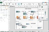
Create flowcharts easily with this free Windows software. Whether you're mapping out ideas, laying out the structure of your organization or creating UML diagrams, ClickCharts is the perfect user-friendly program to get you going. Simplify complex processes, troubleshoot bottlenecks and find areas for improvement. Organize your ideas visually and make even the most complicated process easier to...
Category: Business & Finance / Business Finance
Publisher: NCH Software, License: Freeware, Price: USD $0.00, File Size: 1.7 MB
Platform: Windows
Korti is a Google Earth plugin which allows you to see the unique 3D satellite map of Korti within your Google Earth application.
Korti provides you a detailed satellite imagery and Geographic information about this Geographic place.
To have Korti installed on your PC, first install for free Google Earth and then Korti 3D map plugin. After that, simply double click...
Category: Multimedia & Design / Multimedia App's
Publisher: Maplandia, License: Freeware, Price: USD $0.00, File Size: 309 B
Platform: Windows
Shareware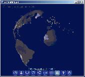
Wandering IPs is geolocation software. Once launched it monitors TCP connections made to or from your PC, identifies remote IP adresses and then tries to determine their Geographic locations. Results are displayed on textured. iluminated accordingly to time zone you're currently in, 3D globe. Apart from locating endpoinds, it can be used to determine the route taken by packets across an...
Category: Internet / Tools & Utilities
Publisher: Marek Jablonski, License: Shareware, Price: USD $12.99, File Size: 1.0 MB
Platform: Windows
Get a full 3D satellite map view of El Petacon on your PC.
Get a full 3D satellite map view of El Petacon on your PC. If you have already installed Google Earth, you will be able to view the El Petacón 3D map. You will enjoy a beautiful view of this Geographic place and you will have the world's Geographic information at your fingertips.
Category: Home & Education / Miscellaneous
Publisher: Maplandia, License: Freeware, Price: USD $0.00, File Size: 331 B
Platform: Windows
Simple-to-use tool with minimalistic interface takes your PL/SQL code and converts it to an interactive UML Activity Diagram allowing you to control Diagram granularity and fast double-click based navigation between Diagram and original code. This gives you not only high perspective view, but also a most efficient way to undersand your code and imact of code changes....
Category: Software Development
Publisher: Crealoq s.r.o., License: Freeware, Price: USD $0.00, File Size: 2.3 MB
Platform: Windows
PostGIS is unique software that adds support for Geographic objects to the PostgreSQL object-relational database.
In effect, PostGIS "spatially enables" the PostgreSQL server, allowing it to be used as a back-end spatial database for Geographic information systems (GIS), much like ESRI's SDE or Oracle's Spatial extension. PostGIS follows the...
Category: Business & Finance / Database Management
Publisher: Refractions Research, License: Shareware, Price: USD $0.00, File Size: 11.2 MB
Platform: Windows
Shareware
Edraw is a new UML Diagram and software Diagram drawing tool for software engineers and designers. Easy to draw uml model Diagram, COM and OLE, data flow model Diagram, Jacobson Use Case, SSADM Diagram, Nassi-Schneiderman diagrams, Booch OOD diagrams, ROOM Diagram, Yourdon and Coad diagrams and Shlaer-Mellor OOA diagrams, program structure diagrams,...
Category: Games / Tools & Editors
Publisher: edrawsoft.com, License: Shareware, Price: USD $69.95, File Size: 34.6 MB
Platform: Windows
Here you will find the World Wind SDK for Java.
Here you will find the World Wind SDK for Java. With this, developers can embed World Wind technology in their own applications.
World Wind Java provides a rich set of features for displaying and interacting with Geographic data and representing a wide range of geometric objects.
- Open-source, high-performance 3D Virtual globe API and SDK
- Adds...
Category: Home & Education / Miscellaneous
Publisher: NASA, License: Shareware, Price: USD $0.00, File Size: 73.5 MB
Platform: Windows
The leading GPS interface tool for Windows!
The leading GPS interface tool for Windows! GPS answers the significant world demand for accurate, viable and cost effective positioning systems. The Geographic Tracker delivers all of the power and utility of GPS to the Windows environment by allowing you to link a GPS receiver to other Microsoft Windows applications through standard Windows DDE messaging.
Category: Home & Education / Miscellaneous
Publisher: Bluemarble Geographics, License: Shareware, Price: USD $0.00, File Size: 0
Platform: Windows
gvSIG Desktop is a powerful Geographic information system (GIS) designed to offer a free solution to all needs related to Geographic information management. It is characterized as a comprehensive, easy to use solution, it adapts to the needs of any GIS user. Access to the most common formats, both vector and raster, both local and remote is possible. It integrates with OGC...
Category: Multimedia & Design / Multimedia App's
Publisher: gvSIG Association, License: Freeware, Price: USD $0.00, File Size: 149.5 MB
Platform: Windows
The Nevron Diagram for .NET is a fully managed, extensible and powerful diagramming framework, which can help you create interactive and feature rich Diagram and map solutions in WinForms and ASP.NET projects. The product is based on the solid Model - View - Controller architecture, which ensures the scalability of its object model. The API is designed to be as native and...
Category: Software Development / Components & Libraries
Publisher: Nevron Software LLC, License: Shareware, Price: USD $589.00, File Size: 245.0 MB
Platform: Windows
Amazing photos, the most successful, incredible views and precise focuses.
Amazing photos, the most successful, incredible views and precise focuses. There?s no need to tell a lot about the quality of National Geographic?s pictures.
Category: Desktop Enhancements / Screensavers
Publisher: 3d-screensaver-jam.com, License: Freeware, Price: USD $0.00, File Size: 3.4 MB
Platform: Windows, Mac, Vista, 2008