Free Downloads: Gis Data Model Diagram
Software Ideas Modeler is a lightweight and powerful tool for the creation of UML diagrams and some other diagrams. It supports all 14 types of UML diagrams, Mixed Diagram, Data Flow Diagram, Flowchart Diagram, Robustness Diagram, Entity Relationship Diagram, Requirement Diagram, User Interface modeling and CRC Card Diagram.
Category: Software Development / Misc. Programming
Publisher: Dusan Rodina, License: Freeware, Price: USD $0.00, File Size: 1.7 MB
Platform: Windows, Linux
The CANVAS 9 Advanced Gis Mapping Edition adds native support for Geographic Information System (Gis) Data to Canvas. You can take measurements in geographic coordinates, import industry standard SHAPE and GeoTIFF files into unlimited numbers of automatically aligned overlapping layers and choose among the following options:·2,104 Coordinate Reference...
Category: Multimedia & Design / Multimedia App's
Publisher: ACD Systems, License: Shareware, Price: USD $999.95, File Size: 51.9 MB
Platform: Mac, PPC
AEGIS– the leading GIS software in UK secondary schools.
AEGIS– the leading Gis software in UK secondary schools.
One-off software purchase and free upgrades – no subscriptions.
Brings industry-standard Gis maps to the classroom – Goad town plans, large-scale OS MasterMaps.
Try before you buy with the free AEGIS Viewer download.
Free materials: resources, help sheets,...
Category: Home & Education / Miscellaneous
Publisher: AU Enterprises Limited, License: Shareware, Price: USD $0.00, File Size: 0
Platform: Windows
UCanCode Releases Upgraded E-XD++ Visualization Suite V13.02 With: -- Label & Report Source Code Solution -- SCADA & HMI Source Code Solution -- Process Simulation Source Code Solution -- Graphics Drawing Source Code Solution -- Gis Source Code Solution -- Real- Data display source code Solution -- Flow Chart & Diagram Source Code Solution...
Category: Software Development / Components & Libraries
Publisher: ucancode software, License: Demo, Price: USD $800.00, File Size: 19.1 MB
Platform: Windows
NexGeo Office™ provides all of the functionality needed to organize a Data collection project and manage Data collected from Nexteq GPS/Gis handhelds. It provides tools for viewing, editing and exporting Data to a format suitable for your existing Gis and CAD infrastructure.
Category: Multimedia & Design / Image Editing
Publisher: Nexteq Navigation, License: Freeware, Price: USD $0.00, File Size: 7.4 MB
Platform: Windows
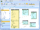
ERCreator Database Edition is a price-competitive and productive ER-Diagram tool for Data modeling and database design. t lets you design and document your datamodel in a database Diagram (ERD) in an easy-learned Diagram tool.
You can print reports and database diagrams and even check the datamodel for consistency. In addition, you can also generate...
Category: Business & Finance / Database Management
Publisher: ModelCreator Software, License: Shareware, Price: USD $99.00, File Size: 2.1 MB
Platform: Windows
GeoMedia Viewer is an easy to use, FREE Gis software application for desktop viewing and distribution of geospatial Data.It allows an organization to maximize the value of its geospatial Data by extending availability to novice users who wouldn’t otherwise have access because of the barriers of purchasing and learning how to use a full Gis software application.
Category: Multimedia & Design / Graphics Viewers
Publisher: Intergraph Corporation, License: Freeware, Price: USD $0.00, File Size: 115.0 MB
Platform: Windows
NOV Diagram for .NET is built upon the NOV Document Object Model (DOM) and is a scalable and extensible solution. It has been carefully designed to meet a vast amount of customization requests. The object Model and the API had been thoroughly refined to be as native and intuitive as possible. NOV Diagram for .NET features: Drawings: Drawings are constructed by...
Category: Software Development / Components & Libraries
Publisher: Nevron Software LLC, License: Shareware, Price: USD $949.00, File Size: 184.6 MB
Platform: Windows
 Shareware
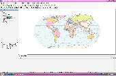
AvisMap Desktop Professional 5 is a professional desktop Gis software for map editing, managing, analysis attribute Data, aid decision-making transactions and output map, print tables, 3D modeling, and other functions. As a complete analysis management tool, AvisMap Despro 5 is applicable in land management, forestry, electric power, telecom, traffic, city pipe network, resource...
Category: Multimedia & Design / Graphics Viewers
Publisher: AvisMap GIS Technologies, License: Shareware, Price: USD $499.00, File Size: 22.2 MB
Platform: Windows
DTM Data Modeler is a CASE tool for database developers that supports both forward and reverse engineering. It is an easy-to-use tool allowing you to work both with logical and physical Data models in the form of an entity-relationship (IDEF1X notation) Diagram. The product is intended for database architects and developers and works with Data sources via the ODBC,...
Category: Business & Finance / Database Management
Publisher: DTM soft, License: Demo, Price: USD $179.00, File Size: 1.2 MB
Platform: Windows
SuperGIS DataConvertor is a powerful Data conversion tool which is able to convert files between the common Gis formats to the SuperGeo self-defined formats. Therefore, your Data can be used in SuperGeo series products, and also the SuperGeo self-defined formats can be used in other related platforms or systems. You will no longer need to worry the compatibility of...
Category: Business & Finance / Calculators
Publisher: SuperGeo, License: Freeware, Price: USD $0.00, File Size: 3.2 MB
Platform: Windows
InstantAtlas™ DeskTop, a product developed by GeoWise and which you can buy from ESRI (UK), enables information analysts and Gis professionals to create highly-interactive web solutions that combine statistics and Gis Data to improve visualisation, enhance communication, and engage people in more informed decision making.
InstantAtlas DeskTop is quick and...
Category: Multimedia & Design / Multimedia App's
Publisher: GeoWise, License: Demo, Price: USD $0.00, File Size: 552.0 KB
Platform: Windows
Diagram for Silverlight has the ability to present powerful and feature-rich diagrams.
Diagram for Silverlight has the ability to present powerful and feature-rich diagrams. It provides an intuitive user-interaction Model for creating and editing diagrams with XAML support. It stores graphical objects in a node graph and renders those objects onto the screen. It explicitly lays out Diagram objects, or lets the LayoutManager handle the job by automatically...
Category: Software Development / Misc. Programming
Publisher: MindFusion, License: Shareware, Price: USD $300.00, File Size: 19.4 MB
Platform: Windows
Diagram Ring is an award-winning advanced diagram editor.
Diagram Ring is an award-winning advanced Diagram editor. It supports lots of Diagram types like Flowcharts, Class Diagrams, DFDs, ERDs, Pie charts, Bar charts and etc.
It has more than 45 predefined symbols and more than 15 predefined styles which really help you design faster.
With it's unique method of connecting nodes it makes drawing diagrams much easier.
Category: Multimedia & Design / Multimedia App's
Publisher: Farshad Barahimi, License: Freeware, Price: USD $0.00, File Size: 372.1 KB
Platform: Windows
Quantum Gis provides a continously growing number of capabilities provided by core functions and plugins. You can visualize, manage, edit, analyse Data, and compose printable maps. QGIS is an official project of the Open Source Geospatial Foundation (OSGeo). It runs on Linux, Unix, Mac OSX, and Windows and supports numerous vector, raster, and database formats and functionalities.
Category: Home & Education / Miscellaneous
Publisher: qgis.org, License: Freeware, Price: USD $0.00, File Size: 92.2 MB
Platform: Windows
ArcGIS Explorer is a free, downloadable Gis viewer that gives you an easy way to explore, visualize and share Gis information. ArcGIS Explorer adds value to any Gis because it helps you deliver your authoritative Data to a broad audience.
The ArcGIS Explorer Desktop Current User setup is intended for users who do not have administrator access on their...
Category: Desktop Enhancements / Shell & Desktop Managers
Publisher: Environmental Systems Research Institute, Inc., License: Freeware, Price: USD $0.00, File Size: 94.0 MB
Platform: Windows
Devgems Data Modeler is the ultimate tool for modeling databases with an easy and simple interface.
Devgems Data Modeler is the ultimate tool for modeling databases with an easy and simple interface. It provides powerful features you need, such as diagramming, reverse engineering, SQL script generation and version control. It keeps track of your changes and generates SQL scripts to update your database according to them. It has smooth integration with development tools like Delphi and...
Category: Business & Finance / Database Management
Publisher: Devgems, License: Shareware, Price: USD $139.00, File Size: 8.2 MB
Platform: Windows
Cityvu is a 3D GIS data viewer able to load CityGML data format from any compatible data source.
Cityvu is a 3D Gis Data viewer able to load CityGML Data format from any compatible Data source.
Cityvu features 3D hardware rendering using OpenGL with a complete navigation system that allows automated tour of the rendered scene. It has been designed to be used to develop customized software solutions, built on the specific needs. Cityvu supports in...
Category: Multimedia & Design / Graphics Viewers
Publisher: 3D GIS Cityvu, License: Freeware, Price: USD $0.00, File Size: 9.9 MB
Platform: Windows
PocketGIS is a powerful mobile Geographical Information System (Gis) for field Data capture which can display and edit map geometry and attributes. PocketGIS brings real Gis functionality to highly portable handheld devices which are lightweight, convenient and have a long battery life.
Category: Utilities / Misc. Utilities
Publisher: Pocket Systems Ltd, License: Shareware, Price: USD $499.00, File Size: 42.8 MB
Platform: Windows
OpenJUMP is an open source Geographic Information System (Gis), it can read and write shapefiles and simple GML files. It has limited support for the display of images and good support for showing Data retrieved from WFS and WMS web-services. So you can use it as Gis Data Viewer.OpenJUMP has limits in reading very large Data files and has limited support for...
Category: Home & Education / Miscellaneous
Publisher: Jump Pilot Project, License: Shareware, Price: USD $0.00, File Size: 0
Platform: Windows
 Commercial
Using Enterprise Analyst, software analysts, architects and developers can validate, simulate and document future system domain models. The tool allows them to concentrate on the core of the system domain logic and is able to test the system during the analysis phase. Some of the important benefits of applying formal analysis are: - Much lower defect rate in the later phases (project...
Category: Software Development / IDEs & Coding Utilities
Publisher: Craftware, License: Commercial, Price: USD $149.00, File Size: 5.7 MB
Platform: Windows
GeoImaging Tools for ArcGIS provides ArcGIS users a suite of tools for processing and analyzing imagery in the Gis.
PCI Geomatics is introducing a suite of modules that integrate directly into ArcGIS for achieving common image related tasks.
Users now have the option to save the correction parameters into the Raster Processing Definition (RPDef) format, reducing...
Category: Software Development / Misc. Programming
Publisher: PCI Geomatics, License: Shareware, Price: USD $0.00, File Size: 43.5 KB
Platform: Windows
At its current development stage, CityZoom is a Decision Support System for urban planning.
At its current development stage, CityZoom is a Decision Support System for urban planning. It provides an environment where different performance models can operate interactively, seeking to optimize the urban planning process. Each of these models corresponds to a module that implements them in the computational environment.
Its main difference and strength if compared to CAD or...
Category: Multimedia & Design / Image Editing
Publisher: CityZoom, License: Demo, Price: USD $0.00, File Size: 9.8 KB
Platform: Windows
SuperGIS Spatial Statistical Analyst is a set of application software integrating geostatistical methods and Gis functions. Besides exploring of spatial Data, query and demonstrating of attribute Data, and the basic statistic capabilities, it also allows users to perform geostatistical analysis to obtain a better understanding about the variance and relativity of spatial...
Category: Multimedia & Design / Multimedia App's
Publisher: SuperGeo Technologies Inc, License: Demo, Price: USD $0.00, File Size: 3.6 MB
Platform: Windows
EasyMap VCL is a Delphi/C++Builder components set for creating your own Gis-related solutions without MapInfo, MapX, MapObjects, WinGIS and so on. EasyMap VCL allows to add following functionalities in Delphi/C++Builder application: - MIF/MID vector maps displaying in Longitude/Lantitude projection; - Map objects related Data in grid or tabular controls displaying; -...
Category: Software Development / Tools & Editors
Publisher: MicroOLAP Technologies LTD, License: Shareware, Price: USD $79.95, File Size: 2.3 MB
Platform: Windows