Free Downloads: Gml
License: All | Free
Renishaw's Geometric Modelling Library (Gml) consists of more than 7,500 functions developed over recent years to resolve many complex geometry problems. The library is now available for trial. Typical usage is within industries such as biomedical, dental, industrial metrology, aerospace and automotive, by those with a need to solve and debug complex geometry problems.
Category: Multimedia & Design / Multimedia App's
Publisher: Renishaw plc, License: Demo, Price: USD $0.00, File Size: 10.5 MB
Platform: Windows
OpenJUMP is an open source Geographic Information System (GIS), it can read and write shapefiles and simple Gml files. It has limited support for the display of images and good support for showing data retrieved from WFS and WMS web-services. So you can use it as GIS Data Viewer.OpenJUMP has limits in reading very large data files and has limited support for cartographic projections.
Category: Home & Education / Miscellaneous
Publisher: Jump Pilot Project, License: Shareware, Price: USD $0.00, File Size: 0
Platform: Windows
 Shareware
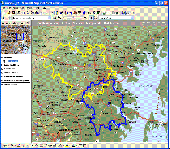
MPSuperShape is a shape manipulation tool for Microsoft MapPoint. MPSuperShape can be used to combine multiple shapes into one large shape, find the intersections (overlaps) between shapes, find boundary shapes around groups of pushpins, simplify shapes, delete multiple shapes, change shape colors, import/export shape files, and to create web pages. Import shape options include ESRI Shape (SHP)...
Category: Business & Finance / Business Finance
Publisher: Winwaed Software Technology LLC, License: Shareware, Price: USD $75.00, File Size: 13.6 MB
Platform: Windows
Shareware
The Advanced points manager imports points to AutoCAD drawing from different data sources. OLE-DB database, SHP (ESRI shape file), GPX (GPS eXchange format), KML (Keyhole Markup Language), Gml (Geography Markup Language), TXT, CSV. Additional options: savable configurations, point coordinate transformation from/to any world coordinate system, point can be ACAD point or ACAD block with...
Category: Business & Finance / Vertical Markets
Publisher: CADdicted inc., License: Shareware, Price: USD $119.00, File Size: 609.8 KB
Platform: Windows
Shareware
Total GIS Converter is an affordable converter of GIS files. It converts AEP, GRD, ADF, E00, FLT, APR, SHP, DXF, BT, TOC, RT1, DEM, DLG, ECW, IMG, DGF, Gml, SID, MIF, TAB, WOR, DNG, DDF, BIL, TIF, JPEG, TTKPS, TTKGP, TTKLS, LFT, PFT, and TFT files. The target formats are TIFF, PNG, JPEG, BMP. The program can scale your GIS files to optimize their size. Besides, it can slice the output...
Category: Multimedia & Design / Graphics Viewers
Publisher: Softplicity, License: Shareware, Price: USD $99.90, File Size: 7.6 MB
Platform: Windows
Do you want to develop computer games without spending countless hours learning how to become a programmer? Then you've come to the right place. GameMaker allows you to make exciting computer games, without the need to write a single line of code. Making games with GameMaker is a lot of fun!
Design your very own games using easy-to-learn drag-and-drop actions – you can...
Category: Multimedia & Design / Graphics Viewers
Publisher: YoYo Games Ltd, License: Shareware, Price: USD $39.99, File Size: 0
Platform: Windows
Shareware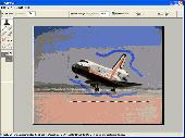
GrowCut is an interactive image cutout & matting tool designed to extract solid or opaque objects as well as objects having smooth or fuzzy edges. Image cutout is the process of removing or isolating an object in a picture. Using advanced image segmentation algorithms GrowCut 3.0 surpasses all other existing cutout programs in feedback time, speed and ease of use. By drawing only vague strokes...
Category: Multimedia & Design / Image Editing
Publisher: iPhotoSoft, License: Shareware, Price: USD $80.00, File Size: 5.0 MB
Platform: Windows
Shareware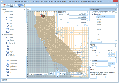
Manco Shapefile Editor is a powerful tool for creating and editing shapefiles, with easy, almost “on the flyâ€, geometry and data editing and possibility of direct creation of the shapefiles from the image files by image processing algorithms. This product is constantly developing and you will receive free updates just when they come. Since it’s only a start of the project,...
Category: Multimedia & Design / Image Editing
Publisher: Manco Software, License: Shareware, Price: USD $100.00, File Size: 6.1 MB
Platform: Windows
T2K Pro integrates the rich world of GIS datasets and transfers your Geographic information data into Google earth. T2K Pro handles rich data types and access large volumes of geographic data stored in files and databases; T2K PRO handles raster (imagery), Vector Map data and GPS Tracks/ Waypoints/ Routes. Tiles2kml Pro provides a complete suite of conversion tools to easily visualize and...
Category: Multimedia & Design / Authoring Tools
Publisher: Tiles2kml, License: Demo, Price: USD $90.00, File Size: 20.9 MB
Platform: Windows

The free AvisMap Viewer opens most GIS/CAD and raster image file types and most ArcView, ArcExplorer, and MapInfo projects. Besides just opening and viewing files, the Viewer supports an extensive list of features including visual layer properties control, legend control, thematic mapping, spatial and attribute querying, custom labeling, on-map measurements, hyper-linking, PDF export and much...
Category: Software Development / Components & Libraries
Publisher: AvisMap GIS Technologies, License: Freeware, Price: USD $0.00, File Size: 22.3 MB
Platform: Windows
License: All | Free