Free Downloads: Map Info Grid
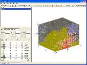
OziExplorer3D is an impeccable application for viewing Map images in 3D, along with the options of rotating it in every possible direction, zoom in/out and lots more. The application actually creates Grid of heights using the height data that has been obtained and writes it to a file, along with the other required information, loads the file and the Map image or the image...
Category: Multimedia & Design / Multimedia App's
Publisher: Des Newman, License: Shareware, Price: USD $30.00, File Size: 1.9 MB
Platform: Windows
In this game there will be a map filled with colored grids.
In this game there will be a Map filled with colored grids. Your colony starts with the home Grid in the center of the Map marked by a flag. The goal of the game is to turn all the grids into the same color. You can change the color of your home Grid and all connected grids by clicking on other colored grids in the Map. Continue the process and you will be...
Category: Games / Misc. Games
Publisher: Novel Games Limited, License: Freeware, Price: USD $0.00, File Size: 264.5 KB
Platform: Windows
Spitfire is a software tool for the Benefon ESC!
Spitfire is a software tool for the Benefon ESC! GPS/GSM mobile phone which allows users to create and load their own or vendor supplied maps into their handset. Spitfire is low cost and simple to use and can load Map images in a variety of bit Map file formats. It provides tools to geographically calibrate a plain bit Map image and correct distortions introduced by...
Category: Business & Finance / Business Finance
Publisher: Barhop Apps, License: Shareware, Price: USD $39.90, File Size: 2.6 MB
Platform: Windows
If you don't have internet access on your phone, or you want to self-select a larger region of mapping, then the Map Chooser tool can be used to make Map tile selections. Choose your own mapping areas with the flexible select tool that lets you select unlimited areas of mapping. Based on a Grid, you can choose any Grid squares you like - so you can pick an area...
Category: Home & Education / Miscellaneous
Publisher: ViewRanger, License: Freeware, Price: USD $0.00, File Size: 213.2 MB
Platform: Windows
 Freeware
Arm Map Explorer recreates all the functionalities of Google Maps on your desktop while expanding them with new extras. Map Explorer lets you locate and view any place on the planet using dynamic interactive maps. These maps are draggable, which means there is no need for you to click and wait for graphics to reload each time you want to view adjacent parts of a Map....
Category: Internet / Flash Tools
Publisher: ArmCode, License: Freeware, Price: USD $0.00, File Size: 5.5 MB
Platform: Windows
Shareware
Toolkit to add GPS functionality to your software and scripts (GPS SDK). All NMEA0183 protocol versions are supported and can be filtered by NMEA sentence type and talker ID. Information on GPS status can also be retrieved: GPS fix quality, satellites used in fix, satellites in view, satellite azimuth, elevation and signal strengths. The toolkit also offers functionality to perform Map...
Category: Software Development / ActiveX
Publisher: Eye4Software B.V., License: Shareware, Price: USD $150.81, File Size: 1.6 MB
Platform: Windows
SemGrid (Simple easy manager of Grid data, for SEMoLa).
SemGrid (Simple easy manager of Grid data, for SEMoLa). Some of its features are: Freeware raster GIS, for Windows OS, import and export of Grid layers from ASCII Grid files of Surfer (grd), GeoMedia (asc), ArcGis (asc) and binary or ASCII from Idrisi32 (rdc, rst), GeoEAS, GRASS, Map algebra, Markov chains estimation and simulation and much more.
Category: Business & Finance / Applications
Publisher: Francesco Danuso, University of Udine, License: Freeware, Price: USD $0.00, File Size: 7.9 MB
Platform: Windows
Shareware
Java toolkit to add coordinate conversion functionality to your Java applications and applets. The toolkit offers functionality to perform Map Grid and datum transformations: latitude and longitude can be converted to various Map grids, like Transverse Mercator (TM), Oblique Mercator, Mercator, Oblique Stereographic, Polar Stereographic, Cassini, Albers Equal Area Conal,...
Category: Software Development / Components & Libraries
Publisher: Eye4Software B.V., License: Shareware, Price: USD $199.00, EUR179, File Size: 155.5 KB
Platform: Unknown
Shareware
GPS SDK to add GPS and coordinate conversion functionality to your software and scripts). All NMEA0183 protocol versions are supported and can be filtered by NMEA sentence type and talker ID. Garmin USB PVT support. Information on GPS status can also be retrieved: GPS fix quality, satellites used in fix, satellites in view, satellite azimuth, elevation and signal strengths. The toolkit also...
Category: Software Development
Publisher: Eye4Software B.V., License: Shareware, Price: USD $99.00, EUR79, File Size: 2.3 MB
Platform: Windows

Commercial realtors require accurate and reliable tools to publish available properties online and show them on the website (specifying region, county, state, and city). We have created a unique Interactive Real Estate Map with all USA states and counties on it for real estate business. USA Real Estate Map is a unique and amazing vector-based tool that is very simple to use....
Category: Internet
Publisher: USFlashMap.com, License: Shareware, Price: USD $399.00, File Size: 3.9 MB
Platform: Windows, Mac, Linux, Unix, MS-DOS, AS/400, OS/2
Geosoft Plug-In for ER Viewer enables users to view and use Geosoft grid (.
Geosoft Plug-In for ER Viewer enables users to view and use Geosoft Grid (.grd) and Map (.Map) files in the ER Viewer application.
This plug-in use a globe explorer, to find, view, and extract data from a variety of data servers. You can use internal servers as well as public servers including DAP servers, WMS servers, ArcIMS servers, and Tile Servers.
Category: Home & Education / Miscellaneous
Publisher: Geosoft Inc., License: Freeware, Price: USD $0.00, File Size: 50.3 MB
Platform: Windows
Cool Flash Map Maker is a powerful Flash Map software for developing interactive flash mapping solutions and products for Real Estate, Spacial Statistics, Business Locator Applications, Vector USA Map,World Map, Germany Map,ASIA Map, Canada Map, Europe Map, Australia Map, Austria Map, Africa Map, UK Map, South...
Category: Multimedia & Design / Multimedia App's
Publisher: Go2Share, License: Shareware, Price: USD $29.95, File Size: 17.9 MB
Platform: Windows

World Map Pro in Flash is a dynamic mapping solution to show any information worldwide Use our Map: - to show international offices (international affiliates, hotel networks, etc) - to show worldwide communities and information on them - to improve search by providing information on any country or region - as a real estate or any other Map/catalogue - to show zones...
Category: Internet
Publisher: USFlashMap.com, License: Shareware, Price: USD $199.00, File Size: 120.0 KB
Platform: Windows, Mac, Linux, Unix, MS-DOS, AS/400, OS/2
Gismaps Viewer is a GIS viewer that can be used for geospatial analysis and map production.
Gismaps Viewer is a GIS viewer that can be used for geospatial analysis and Map production.
The main features are:
- read Shape files using geographic coordinate system
- view satellite images (MrSid, jpeg, bmp and tiff file formats)
- generate thematic maps, queries and labels
- export do Google Earth KML (shp2kml)
- configure Map colors...
Category: Multimedia & Design / Graphics Viewers
Publisher: Gismaps Sistemas Ltda., License: Freeware, Price: USD $0.00, File Size: 10.2 MB
Platform: Windows
With WinPIM, you can:
-Storage contacts info, organize & track them, create relationship map.
With WinPIM, you can:
-Storage contacts Info, organize & track them, create relationship Map.
-Manage time, allocate tasks.
-Compose HTML format diary, notes. Support Sound Recording.
-Communicated with friends via email.
-Sync with mobile phones or PDA, works with other programs.
-Share data over network, access data anytime anywhere.
Category: Business & Finance / Personal Info Managers
Publisher: YQSoft, Inc., License: Shareware, Price: USD $39.95, File Size: 6.4 MB
Platform: Windows
This version is for use with X5.
This version is for use with X5.
This add-on allows for quick and easy one-click toggling on/off the visibility and active state of the Grid.
These enhancements and updates have been tested and released by the Quality Control Department and will function inside Mastercam X5. Follow the instructions given in the 'Info' button of each download for install...
Category: Multimedia & Design / Multimedia App's
Publisher: CNC Software, Inc., License: Freeware, Price: USD $0.00, File Size: 526.9 KB
Platform: Windows
Creating graphs of regular data and irregular data. Creating vertex, Grid and surface model, Delaunay triangles, color Map, contour plot, vector plot, 3D contour plot, 4D scatter, 4D slice and 4D vector.
Category: Home & Education / Science
Publisher: GraphNow, License: Shareware, Price: USD $59.95, File Size: 2.6 MB
Platform: Unknown
Shareware
The Eye4Software Coordinate Calculator is an easy to use tool to perform Map or GPS coordinate conversions. The software can be used to transform a single coordinate or a batch of coordinates read from a comma separated, database or ESRI shapefiles. The software is shipped with a MS Access database file, containing more then 3500 ellipsoid, Map datum and Map Grid...
Category: Business & Finance / Calculators
Publisher: Eye4Software B.V., License: Shareware, Price: USD $49.00, EUR39, File Size: 3.2 MB
Platform: Windows
Grid Matrix is a Graphical Grid simulator for Windows that is implemented over SimGrid.
Grid Matrix is a Graphical Grid simulator for Windows that is implemented over SimGrid.
Grid Matrix uses SimGrid toolkit to run the simulation. The network can be defined using a graphic interface and run within the application.
The simulation code is written in Python using bindings to SimGrid.
Category: Software Development / Misc. Programming
Publisher: Pablo Yabo, License: Freeware, Price: USD $0.00, File Size: 5.7 MB
Platform: Windows
Detail Grid – The detail grid holds the details of data read from the meter.
Detail Grid – The detail Grid holds the details of data read from the meter. You can navigate, via he expandable Grid layout, to see individual Session, Run and Data Point information. You can even click on a Chart button on a Run Grid row to see a chart of the Run’s data points.
Category: Internet / Misc. Plugins
Publisher: Allen Face and Companies LLC, License: Freeware, Price: USD $0.00, File Size: 2.9 MB
Platform: Windows
Omni Grid is a plug-in for SU Podium V2 or for SU Walk that allows you to create a Grid of point lights or omni lights above or below a planar surface (SketchUp face). By creating a Grid of omni lights Omni Grid creates a relatively even source of light over a wide space. It is best for interior rendering. An alternative to omni Grid is Hidden LEM.
Category: Multimedia & Design / Multimedia App's
Publisher: Cadalog Inc., License: Freeware, Price: USD $0.00, File Size: 328.5 KB
Platform: Windows
USA Real Estate Map Pro is a premium class software for mapping: real estate properties, contact listings, offices and other geo spatial data. Interactive Real Estate Map is rather simple to integrate with database listings: both to specify the states and counties that should be active on Map, and pass the selected county name or ID back, for further use. Among the benefits...
Category: Business & Finance / Database Management
Publisher: USFlashMap.com, License: Shareware, Price: USD $399.00, File Size: 10.4 MB
Platform: Windows, Mac, Linux, Unix, MS-DOS, AS, 400
Shareware
iGrid plots drawing Grid right over your desktop, so you can use it everywhere, with any drawing application without any special plugins for different graphics applications. Just install and run iGrid and you'll see Grid plotted over entire screen: Click left mouse button on the iGrid's tray icon to show/hide the Grid or right mouse button to see iGrid's menu. Choose...
Category: Multimedia & Design / Image Editing
Publisher: Greatis Software, License: Shareware, Price: USD $13.00, File Size: 428.8 KB
Platform: Windows
Provides a very intuitive visualisation of your ride or run by coloring the track on the Map according to speed/pace, heart rate and lots of other parameters.
Track Coloring plugin is a port of parts of our ST2 "Map Overlay plugin" to ST3. It took a while, but now this outstanding work has been done.
The plugin has two major features: track coloring...
Category: Business & Finance / Business Finance
Publisher: Old Man Biking's SportTracks Plugins, License: Shareware, Price: USD $7.17, File Size: 915.7 KB
Platform: Windows
OziExplorer is a flamboyant GPS Mapping Software that runs on the PC and works with varieties of GPS receivers such as Garmin, Lowrance, Magellan, Eagle, Brunton, Silva and MLR for the uploading or downloading the waypoints, routes and tracks and most brands of GPS receivers for real time tracking of GPS position.
Using this software, the user can use maps and charts that can be...
Category: Internet / Communications
Publisher: Des Newman, License: Shareware, Price: USD $95.00, File Size: 6.8 MB
Platform: Windows