Free Downloads: Nasa Cern Csim Map
Collection of 900 Nasa photos that can be used as desktop background wallpaper or to view by slideshow. Random collection of the shuttle, the international space station, more. Most photos are very large 1200 x 1600 resolution and includes some never seen before photos of Mars landscape. Some photos are so amazing they are truly spectacular from orbital views and most in sharp color....
Category: Desktop Enhancements / Skins
Publisher: Tekware, License: Shareware, Price: USD $24.99, File Size: 956.0 KB
Platform: Windows
The Virtual Microscope is a Nasa-funded project that provides simulated scientific instrumentation for students and researchers worldwide as part of Nasa?s Virtual Laboratory initiative.
Category: Home & Education / Mathematics
Publisher: virtual.itg.uiuc.edu, License: Freeware, Price: USD $0.00, File Size: 135.2 MB
Platform: Windows, Mac, Linux
 Shareware
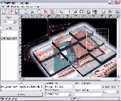
Create HTML Image Maps of any shape in just a few clicks! Map Designer automates the creation of HTML Image Maps, making it easy for designers and Web developers to specify hot-links and clickable areas within images. Map Designer helps Web developers specify rectangular, round or arbitrary-shape areas in a what-you-see-is-what-you-get mode. Specifying an active region with...
Category: Web Authoring / HTML Editors
Publisher: ForthTech Software, License: Shareware, Price: USD $23.00, File Size: 1.1 MB
Platform: Windows
Cool Flash Map Maker is a powerful Flash Map software for developing interactive flash mapping solutions and products for Real Estate, Spacial Statistics, Business Locator Applications, Vector USA Map,World Map, Germany Map,ASIA Map, Canada Map, Europe Map, Australia Map, Austria Map, Africa Map, UK Map, South...
Category: Multimedia & Design / Multimedia App's
Publisher: Go2Share, License: Shareware, Price: USD $29.95, File Size: 17.9 MB
Platform: Windows
Want to see the same images that scientists at Nasa use for their research or perform your own research with those images? Or do you want to see the Earth from the same perspective that astronauts see as they descend to Earth? How about taking a 5 minute break and viewing a panorama of a different city? Install WWT and start your explorations.
Category: Home & Education / Astrology & Numerology
Publisher: Microsoft, License: Freeware, Price: USD $0.00, File Size: 60.7 MB
Platform: Windows
Freeware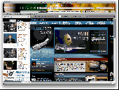
Dress up your Firefox browser with 3 stunning Nasa and space inspired scenes for your Firefox browser. Includes links to cool space sites and a sidebar with photos and videos! These themes are free and we switch your default search engine to ASK and Yahoo! but you can easily switch back to your favorite, if needed. Here's the quick summary of a Brand Thunder Boom: 1. Booms are...
Category: Internet / Browser Accessories
Publisher: Brand Thunder, License: Freeware, Price: USD $0.00, File Size: 669.9 KB
Platform: Windows
Shareware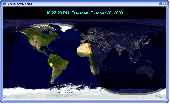
Crave World Clock is a nice looking clock for people having customers from around the world. You can view current time and date for all cities and countries on your desktop using a real world Map which shows day / night effects and real-time imagery provided by Nasa. You can set the clock theme to any of predefined (Silver, Blue or Copper) themes and match it with your...
Category: Desktop Enhancements
Publisher: Crave Worldwide, License: Shareware, Price: USD $14.95, File Size: 2.0 MB
Platform: Windows
Watch Nasa TV including live space shuttle launches and space walks plus all the Sky at Night programs from December 2001 up to the current episode over the internet plus view live solar images and get ISS (international space station) and satellite pass predictions for your location. View 9 Nasa TV channels. 62 Plus BBC Sky at Night programs From December 2001 to current...
Category: Home & Education
Publisher: SCES Software, License: Freeware, Price: USD $0.00, File Size: 3.4 MB
Platform: Windows
Remere's Map Editor is a map editor for the OpenTibia Project which was created by Remere.
Remere's Map Editor is a Map editor for the OpenTibia Project which was created by Remere.
Remere's Map Editor is a Map editor coded in C to be used with OpenTibia. It supports many advanced features such as autobordering and placing of composite objects. Runs under both Linux and Windows using wxWidgets and OpenGL.
Category: Games / Tools & Editors
Publisher: Remere, License: Shareware, Price: USD $0.00, File Size: 4.2 MB
Platform: Windows
This screen saver has 42 photos of experimental aircraft from Nasa and the Dryden Flight Research Center, dating from the 1940's to the 1990's.
Many of the aircraft are captured in flight, over beautiful terrain. While most are truly X-craft, some are more familiar aircraft with experimental modifications.
All photos include captions (optionally turned...
Category: Desktop Enhancements / Screensavers
Publisher: Auralis, Inc., License: Shareware, Price: USD $9.95, File Size: 1.7 MB
Platform: Windows
Freeware
An interactive Flash USA Map with all the features you need for your web site or project. This is the ideal solution for dealer maps, real-estate listings, or visualizing state statistics. Nearly every aspect of the Map is customizable. However, unlike competing products, our Map is very simple to install and edit. Just upload XML and SWF files and embed.
Category: Internet / Flash Tools
Publisher: http://www.flashusamap.com/trial/flashus, License: Freeware, Price: USD $0.00, File Size: 93.8 KB
Platform: Unknown
Map of Africa is one of the many maps created for GPS TrackMaker.
Map of Africa is one of the many maps created for GPS TrackMaker. You are able to download the installation package from the TrackMaker website. In order to preview the contents of this package, you need to install GPS TrackMaker.
Using the above mentioned application, you will be able to see the Map of Africa. Just click on the "Open Temporary...
Category: Home & Education / Miscellaneous
Publisher: Geo Studio Technology, License: Freeware, Price: USD $0.00, File Size: 18.3 MB
Platform: Windows
The G-LOGGERTM system was originally designed as a vibration monitor for Nasa and the Space Shuttle Program. It provides portable, lightweight, and easy to use acceleration and temperature acquisition for a variety of applications. It is self-contained, sealed from the weather and can operate unattended for 7 to 21 days on two D-cell alkaline batteries, depending upon the sample rate and...
Category: Utilities / Misc. Utilities
Publisher: Silicon Designs, Inc., License: Freeware, Price: USD $0.00, File Size: 321.1 KB
Platform: Windows
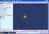
This is a 3D simulation of the Mars surface exploration done by the Rover remote operated vehicle Spirit.
Nasa began to experience what seemed to be very dire communication problems with Spirit on January 22. However, after the incredible efforts of the Mars rover team, the problem has been diagnosed and the rover should be able to continue its scientific mission soon.
...
Category: Games / Misc. Games
Publisher: Brain Block Interactive, License: Freeware, Price: USD $0.00, File Size: 1.2 MB
Platform: Windows
Program shows you an actual X3 sector-map, with detailed information about most in-game objects.
Program shows you an actual X3 sector-Map, with detailed information about most in-game objects. The Map is based on a log-file that is created with an in-game script (by Andrei[<>Ace]). If you just want to view the standard Map (or if you don’t have the game) the program will work with the included default Map, which was created with an English X3 game...
Category: Games / Misc. Games
Publisher: SUU Design, License: Freeware, Price: USD $0.00, File Size: 1.4 MB
Platform: Windows
New Zealand Map Reference Converter (NZMapConv) is software that LINZ provides to convert Map references between the old NZMS260 Map series and the new NZTopo50 Map series.NZMapConv is a Windows programme designed to convert individual coordinates entered manually.
Category: Multimedia & Design / Media Management
Publisher: Land Information New Zealand, License: Freeware, Price: USD $0.00, File Size: 2.4 MB
Platform: Windows
When the XMAP software is communicating with an XEDE via the comms cable each Map will show, at the top of the Map display, an RPM and load value (x and y axis for the Map) in real time. Also in each Map a yellow highlighted block will show the current position within the Map. Beside the real-time display on each Map are the undo and redo buttons which...
Category: Home & Education / Miscellaneous
Publisher: ChipTorque, License: Freeware, Price: USD $0.00, File Size: 1.7 MB
Platform: Windows
Sig Panama Has :
Digital maps of Panama, Digital Map of Panama-City, digital Map of Taboga, digital Map of Bocas del Toro, digital Map of Colon and Free Zone, digital Map of Contadora Island, digital Map of Coronado, Panama, Zona Libre, Map of Panama, Map of Panama City, Map of Colon, Map of Zona Libre, Map of...
Category: Internet / Misc. Plugins
Publisher: DP Imperial, LLC., License: Freeware, Price: USD $0.00, File Size: 44.9 MB
Platform: Windows
Live!Flight allows that everyone can track your flight in flight simulator in real-time, all over the world. Your aircraft is displayed as a 3D-model in a Map of Nasa World Wind.
For that purpose Live!Flight transmits position and flight attitude information. With a refreshing rate of 2 times per second you can see every aircraft's movement. A lot of more...
Category: Business & Finance / Business Finance
Publisher: Christoph Paulus, License: Shareware, Price: USD $29.00, File Size: 4.2 MB
Platform: Windows
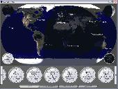
ActiveEarth is a world time clock with a gorgeous day/night merge of Nasa's Visible Earth satellite images in flat maps or a globe, with a row of user-definable clocks along the bottom. These clocks are beautiful, scalable, ticking, analog clocks that come in several styles with many custom settings. Each clock is set to a city of your choice. The program has accurate time zone data for...
Category: Business & Finance
Publisher: Norris Family Industry, License: Demo, Price: USD $24.95, File Size: 2.8 MB
Platform: Windows
Freeware
Arm Map Explorer recreates all the functionalities of Google Maps on your desktop while expanding them with new extras. Map Explorer lets you locate and view any place on the planet using dynamic interactive maps. These maps are draggable, which means there is no need for you to click and wait for graphics to reload each time you want to view adjacent parts of a Map....
Category: Internet / Flash Tools
Publisher: ArmCode, License: Freeware, Price: USD $0.00, File Size: 5.5 MB
Platform: Windows
Time Zones Map is the flash world time Map featuring the time peculiarities of more then 50 cities all over the world. Its eye-catching but still pleasant design, varied functions and multiple application abilities combine everything the ultra-modern flash world time Map must have. You can put our Time Zone Map either on one of your website?s pages or put a banner,...
Category: Web Authoring / Flash Utilities
Publisher: USFlashMap.com, License: Shareware, Price: USD $249.00, File Size: 45.0 KB
Platform: Windows, Mac, Linux, Unix, MS-DOS, AS, 400
The easiest way to get a paper map with MapPlot is the Plot Map menu.
The easiest way to get a paper Map with MapPlot is the Plot Map menu.
On the following dialog, simply paper size and scale have to be chosen - the result is ready to be printed directly, edited (e.g. for additional entries) or to be displayed as a preview.
Category: Utilities / Misc. Utilities
Publisher: AGIS GmbH, License: Freeware, Price: USD $0.00, File Size: 5.4 MB
Platform: Windows
With LocationWizard you can easily map multiple addresses on a map.
With LocationWizard you can easily Map multiple addresses on a Map. LocationWizard helps you visualize the locations of customers or shops. LocationWizard supports the following database formats: MySQL, PostgreSQL, SQLite, FireBird, InterBase, Microsoft Access, Microsoft Excel and CSV.
Category: Business & Finance / Business Finance
Publisher: Location Wizard team, License: Shareware, Price: USD $85.00, File Size: 7.3 MB
Platform: Windows
OziExplorer3D is an impeccable application for viewing Map images in 3D, along with the options of rotating it in every possible direction, zoom in/out and lots more. The application actually creates grid of heights using the height data that has been obtained and writes it to a file, along with the other required information, loads the file and the Map image or the image section...
Category: Multimedia & Design / Multimedia App's
Publisher: Des Newman, License: Shareware, Price: USD $30.00, File Size: 1.9 MB
Platform: Windows