Free Downloads: Noaa
License: All | Free
A photoshop plugin which allows you to read Noaa marine charts.Noaa marine charts are the standard raster charts and have the file extension of *.bsb and *.kap.Once a chart is imported into Photoshop you can:- Print the chart.- Paste charts together to cover a larger area.- Create and print your own custom charts to cover the area you want.- Edit Charts.- Print a small area of a...
Category: Multimedia & Design / Image Editing
Publisher: Apocgraphy, License: Shareware, Price: USD $20.00, File Size: 20.5 KB
Platform: Unknown
ENCX UDE is ideal for NOAA ENC charts, to introduce marine chart displays into your system.
ENCX UDE is ideal for Noaa ENC charts, to introduce marine chart displays into your system. The technology is mature with a considerable pedigree in the industry, including hydrographic offices, navies and major oil companies. It is extremely fast and benefits from 16 years experience of the development of high performance navigation systems.
It is extremely accurate and is...
Category: Business & Finance / Business Finance
Publisher: CherSoft Ltd., License: Freeware, Price: USD $0.00, File Size: 42.7 MB
Platform: Windows
Bluewater Racing lets you view and manipulate Grib files, competition management, route optimization, and GPS data. A NMEA instrument panel and and support for currents in the performance and optimization calculations is in development, as well as support for the Noaa vector chart format.
Bluewater Racing exclusively uses high-quality, free, publicly available data from...
Category: Home & Education / Miscellaneous
Publisher: 2FB, Inc., License: Shareware, Price: USD $0.00, File Size: 0
Platform: Windows
Chips, the Copenhagen Image Processing System, is a general-purpose software package for remote sensing image processing and spatial data analysis with extensive support for Noaa AVHRR data.
Chips can be used both as a stand-alone system, as well as a powerful supplemental image-processing tool for GIS products like MapInfo™ and ArcView™.
Category: Multimedia & Design / Multimedia App's
Publisher: Chips Development Team, License: Freeware, Price: USD $0.00, File Size: 5.9 MB
Platform: Windows
GetNexrad is a tool used to view Noaa WSR-88D Nexrad doppler radar images and compute point and area average rainfall and to generate the basin point file used by GetRealtime application for automating computation of a basin average rainfall time series in real time.
Traditional area average rainfall is obtained by rainfall gages located in or near the area of interest and...
Category: Business & Finance / Applications
Publisher: Carson, License: Shareware, Price: USD $0.00, File Size: 0
Platform: Windows
 Shareware
A program to receive weather reports, navigational warnings and weather charts transmitted on longwave and shortwave bands. Supported modes are RTTY, NAVTEX and HF-FAX (WEFAX). It can decode GMDSS DSC (HF and VHF) messages. Software also can automatically save Noaa Weather Radio SAME voice messages (NWR SAME) and them digital headers. None additional hardware is required - your need only...
Category: Home & Education / Hobbies
Publisher: DXsoft, License: Shareware, Price: USD $49.00, EUR39, File Size: 1.5 MB
Platform: Windows
See the latest U.S. weather forecast, radar and satellite pictures to find turbulence when you're connected to the Internet. When you're not connected, the screensaver will display the last picture, which is automatically saved until you reconnect. Find the turbulent air across North America. See seven images all updated as soon as Noaa gets the data. Pictures display for 10...
Category: Desktop Enhancements / Screensavers
Publisher: Proactive Information Corporation, License: Freeware, Price: USD $0.00, File Size: 745.1 KB
Platform: Windows
EOLi (Earth Observation Link) is the European Space Agency's client for Earth Observation Catalogue and Ordering Services.
Using EOLi, you can browse the metadata and preview images of Earth Observation data acquired by the satellites ENVISAT, ERS, Landsat, IKONOS, DMC, ALOS, SPOT, Kompsat, Proba, JERS, IRS, Nimbus, Noaa, SCISAT, SeaStar, Terra/Aqua.
Category: Multimedia & Design / Multimedia App's
Publisher: European Space Agency, License: Freeware, Price: USD $0.00, File Size: 54.7 MB
Platform: Windows
GetRealtime automates downloading free real-time hydrologic and meteorological data at scheduled intervals for display. Supports USGS, Wunderground, USBR, USCS Snotel, CDEC, CIMIS, and Noaa WSR-88D Radar.
GetRealtime - automated retrieval, computation, and storage of real-time hydrological and meteorological data available free on the web.
Category: Internet / Download Managers
Publisher: Carson, License: Freeware, Price: USD $0.00, File Size: 4.2 MB
Platform: Windows
The Weather Globe screen saver accesses our servers several times an hour for updated weather information which is automatically uploaded. Weather is downloaded from Noaa (the National Oceanic and Atmospheric Administration) where it is mapped into polar coordinates on our servers and uploaded to the globe that you see in your screen saver. The weather current within 2 hours. Since this...
Category: Desktop Enhancements / Screensavers
Publisher: PBHLLC, License: Freeware, Price: USD $0.00, File Size: 837.0 KB
Platform: Windows
EASAlert provides supplementary Weather and EAS (Emergency Alert System) notification for First Responders, Emergency Managers, broadcasters, storm spotters, and anyone who needs immediate notification of Weather or Civil Emergencies. EASAlert is an autonomous email/SMS-MMS alert notification system triggered by any programmable EAS or Noaa Weather Radio S.A.M.E. code.
Category: Home & Education / Miscellaneous
Publisher: BW Consultants, License: Shareware, Price: USD $0.00, File Size: 6.2 MB
Platform: Windows

Weather Forecasts For Your PC - Live Weather Reports on Your Desktop. Get one-click weather reports, live temperatures, alerts, 3d sattelite maps, free 7 day forecasts and more right from your desktop. Easy to use and install, contains NO spyware, NO adware - and it doesn't interfere with your Start bar or internet browsers. Be the first to know about weather systems in your area - or anywhere...
Category: Utilities
Publisher: FunDesktops, License: Freeware, Price: USD $0.00, File Size: 373.1 KB
Platform: Windows
Weather Station For PC - Get Live Weather Reports On Your Desktop. Get one-click weather reports, live temperatures, alerts, 3d sattelite maps, free 7 day forecasts and more right from your desktop. Easy to use and install, contains NO spyware, NO adware - and it doesn't interfere with your Start bar or internet browsers. Be the first to know about weather systems in your area - or anywhere in...
Category: Internet
Publisher: FunDesktops, License: Freeware, Price: USD $0.00, File Size: 373.1 KB
Platform: Windows
ClickClock is a handy program which is not only a clock, but also a calendar, weather forecast and astronomy program. It provides you with a comprehensive information about time, holidays, local temperature, date and time of sunrise or sunset and of moonrise or moonset and lots of things connected with astronomy, like moon phases, position of the planets, meteor showers, equinoxes and solstices...
Category: Business & Finance / Personal Info Managers
Publisher: Michael Robinson, License: Shareware, Price: USD $20.00, File Size: 6.5 MB
Platform: Windows
Earth and Moon screensaver provides dramatic views from high above the Earth. Rotate 21 different photos Earth and lunar shots. The program is powered by an excellent screen-saver engine, which lets you adjust the time between slide changes, show pictures full-screen or at original size, mute the relaxing MIDI-based soundtrack, use up to 23 transition effects, and take advantage of Microsoft...
Category: Desktop Enhancements / Screensavers
Publisher: NexusMedia, License: Shareware, Price: USD $10.00, File Size: 190.7 MB
Platform: Unknown
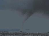
Hurricanes screensaver provides an informative and dynamic look at the power and size of these oceanic monsters. Rotate 30 different satellite views of a few of the recent storms. The program is powered by an excellent screen-saver engine, which lets you adjust the time between slide changes, show pictures full-screen or at original size, mute the relaxing MIDI-based soundtrack, use up to 23...
Category: Desktop Enhancements / Screensavers
Publisher: NexusMedia, License: Shareware, Price: USD $10.00, File Size: 3.1 MB
Platform: Unknown
The Biogeography Branch’s Sampling Design Tool for ArcGIS provides users a means to efficiently sample a population, be it people, animals, objects or processes, in a GIS environment. The tool was created for sampling when the population and component sampling units are defined by known dimensions.
The Sampling Design Tool was developed in response to a need by scientists...
Category: Business & Finance / Applications
Publisher: Center for Coastal Monitoring and Assessment, License: Freeware, Price: USD $0.00, File Size: 236.7 KB
Platform: Windows
TOPCAT is an acronym for Take-Off and Landing Performance Calculation Tool and is a highly realistic, easy-to-use planning tool for all serious flight simulator enthusiasts. It brings into a single application all of the calculations required to plan for safe and repeatable take-offs and landings.
TOPCAT features:
- Microsoft® Windows® application made by...
Category: Business & Finance / Business Finance
Publisher: Christian Grill, License: Shareware, Price: USD $0.00, File Size: 0
Platform: Windows
zyGrib - GRIB File Viewer Weather data visualization.
zyGrib - GRIB File Viewer Weather data visualization.
Visualization of meteo data from files in GRIB Format .
Main Features:
- Available meteo infos (W and CH - *):
- Surface Pressure (*)
- Wind 10 m above mean sea level (*)
- Wind gust (*)
- Temperature 2 m above mean sea level (*)
- Potential Temperature min - max 2 m above...
Category: Business & Finance / Applications
Publisher: Jacques Zaninetti, License: Freeware, Price: USD $0.00, File Size: 20.5 MB
Platform: Windows
Shareware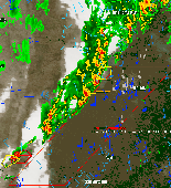
WeatherStudio combines a vast array of live weather data, products, maps, and charts into a single map that the user can pan and zoom. GFS/NDFD/NAM/RUC Model Data, Placefiles, Radar Loops, Satellite, Storm Reports, Hurricane Paths, Surface Observations, Watches/Warnings, Buoys, Shapefiles, GPS support, FTP Uploading, etc. Made for Storm Chasers, Mariners, Meteorologists, yet simple enough for...
Category: Home & Education / Hobbies
Publisher: PaulMarv Software, License: Shareware, Price: USD $80.00, File Size: 13.0 MB
Platform: Windows
WeatherSig is a fun tool that allows you to display your city weather conditions in your email signature for many popular mail programs. Your signature can be inserted manually or automatically into outgoing messages for Microsoft Mail, Outlook Express, Mozilla Thunderbird and more. Now supports Windows Vista. Not only does WeatherSig allow you to insert your current weather conditions...
Category: Internet
Publisher: WeatherSig.com, License: Shareware, Price: USD $19.95, File Size: 1.7 MB
Platform: Windows
License: All | Free