Free Downloads: Route Map Chart
Route Tracer is the application that allows you to trace the Route over the network between two systems, listing all the intermediate routers a connection must pass through to get to its destination. Route Tracer provides the physical geographical locations of network servers and routers. It shows the actual Route path on both the three-dimensional globe and the flat...
Category: Internet / Tools & Utilities
Publisher: MacSeal.COM, License: Shareware, Price: USD $25.00, File Size: 18.2 MB
Platform: Unknown
MyRouteOnline is an easy to use Route planner that that allows you to plan routes from Excel spreadsheet. Excel Add-in that uploads addresses and saves time, fuel and money by helping you Map multiple locations and find the best Route. Online Route planning goes far beyond paper maps or a GPS system, it is the only way to find the optimal Route for your needs,...
Category: Business & Finance / Business Finance
Publisher: MyRouteOnline, License: Freeware, Price: USD $0.00, File Size: 3.1 MB
Platform: Windows
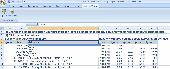
Map&guide base is the ideal solution for anyone who requires a high performance Route planner - whether they work in transport and logistics, as sales professionals or as frequent drivers.
* Map material for all of Europe is constantly and automatically updated
* Fast, seamless navigation around the Map thanks to "speed maps" and a...
Category: Home & Education / Miscellaneous
Publisher: mapandguide, License: Shareware, Price: USD $0.00, File Size: 0
Platform: Windows
Map&guide base is the ideal solution for anyone who requires a high performance Route planner - whether they work in transport and logistics, as sales professionals or as frequent drivers.
Map material for all of Europe is constantly and automatically updated
Fast, seamless navigation around the Map thanks to "speed maps" and a...
Category: Home & Education / Hobbies
Publisher: MAP&GUIDE GmbH, License: Shareware, Price: USD $0.00, File Size: 25.3 MB
Platform: Windows
The C-Map Chart Catalog allows you to view, navigate, select and order C-Map electronic charts, or various weather options, in an interactive way. After selection of required items is completed, simply press the 'E-mail order' button, and enter the address of your local C-Map distributor.
Category: Home & Education / Hobbies
Publisher: Jeppesen Marine, License: Freeware, Price: USD $0.00, File Size: 6.1 MB
Platform: Windows
Nokia Map Manager is a program that allows you to manage and transfer GPS maps to mobile phone.
Nokia Map Manager is a program that allows you to manage and transfer GPS maps to mobile phone. The Map Manager is for the 6110 Navigator only. The program is provided with scan function to search maps on the computer and DVD. Nokia Map Manager is an additional application and is used together with Nokia PC Suite 6.86 and later versions.
Nokia Map Manager helps...
Category: Internet / Communications
Publisher: Nokia, License: Freeware, Price: USD $0.00, File Size: 0
Platform: Windows
You can capture the Google Map window and save it as JPG format, and also show the planned Route on Google Map directly.
Main Features:
- Travel Planning
- Travel database saved by calendar
- Travel detail information
- Travel files list
- Software control Function
Category: Home & Education / Miscellaneous
Publisher: GlobalSat Technology Corporation, License: Freeware, Price: USD $0.00, File Size: 68.1 MB
Platform: Windows
Bluewater Racing lets you view and manipulate Grib files, competition management, Route optimization, and GPS data. A NMEA instrument panel and and support for currents in the performance and optimization calculations is in development, as well as support for the NOAA vector Chart format.
Bluewater Racing exclusively uses high-quality, free, publicly available data...
Category: Home & Education / Miscellaneous
Publisher: 2FB, Inc., License: Shareware, Price: USD $0.00, File Size: 0
Platform: Windows
This Digital Chart covers the following Chart areas: C1, C8, C23, C24, C25, C26, C27, C28, C29, C30, C68, Y9, Y16, Y17, Y18, 2000.3, 2000.6, 2000.7, 2100.2, 2100.4, 2100.6. Imray Digital Charts for the East Coast, North Sea and Channel Coasts were first published at the end of 2005. Their clear and simple format has come to be regarded as one that has set standards for entry level...
Category: Home & Education / Miscellaneous
Publisher: Imray, Laurie, Norie & Wilson Ltd, License: Shareware, Price: USD $117.00, File Size: 13.1 MB
Platform: Windows

GPS Navigator with using a scanned maps and possibility to open a lot of maps together. - you can show a current GPS data (Speed, Direction, Longitude, Latitude, Time, Date, Height); - you can open any of scanned maps (in a "bmp" or "dib" format); - you can calibrate the scanned maps yourself by two calibration points only (left-top and right-bottom); - calibrations are stored...
Category: Home & Education
Publisher: Valeri Vlassov, License: Demo, Price: USD $19.00, File Size: 4.6 MB
Platform: Windows
You will be able to enjoy many of CompeGPS Lands features such as waypoint and Route creation and edition, full communication between PDA and GPS, use of maps and the moving Map (real-time navigation). CompeGPS Pocket Land allows full communication between GPS and PDA (tracks, waypoints and routes). You will be able to create waypoints and routes, use maps and real-time...
Category: Home & Education
Publisher: CompeGPS TEAM S.L., License: Shareware, Price: USD $76.00, File Size: 3.9 MB
Platform:
Electronic chart plotting has never been more affordable or simpler than with seaPro Lite.
Electronic Chart plotting has never been more affordable or simpler than with seaPro Lite. This easy-to-use system combines high quality charts with practical navigation functionality.
seaPro Lite is designed for those who wish to get to grips with PC based Chart plotters without the initial expense of a fully featured system, or feel that the amount of sailing they...
Category: Business & Finance / Business Finance
Publisher: Euronav Ltd., License: Demo, Price: USD $0.00, File Size: 57.3 MB
Platform: Windows
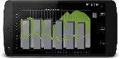
TeeChart Charting Library for Xamarin.Android offers full set of 60+ Chart styles in 2D and 3D, maps and gauges, 50+ financial and statistical indicators and a full set of Chart tools components for additional functionality. The TeeChart for Xamarin.Android license provides support for Android mobile platform and includes a renewable one-year subscription service that entitles...
Category: Software Development / Components & Libraries
Publisher: Steema Software, License: Shareware, Price: USD $339.00, File Size: 15.4 MB
Platform: Mac
Super Route Manager is a comprehensive, fully integrated route management system.
Super Route Manager is a comprehensive, fully integrated Route management system. Developed for Windows system using either Microsoft's Access or SQL Server database, a SRM system represents the industry's most scalable package for AMUSEMENT, VENDING, and most any coin-operated Route operations. Whether you have five or five hundred locations, 100 or 10,000...
Category: Business & Finance / Business Finance
Publisher: Premier Data Software and SieCorp, License: Shareware, Price: USD $67.90, File Size: 10.2 MB
Platform: Windows
The Off-Route Data Acquiring software is designed to
download off-Route data from the STD-500/510/3300
instruments into a file on your computer.
Connect the data collector/analyzer to your
workstation.
-Load off-Route points you need.
-Select off-Route points of interest from the list.
-Save selected off-Route points...
Category: Business & Finance / Business Finance
Publisher: Technekon, License: Freeware, Price: USD $0.00, File Size: 5.3 MB
Platform: Windows
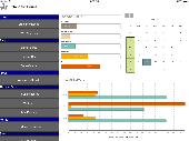
TeeChart Charting component for Xamarin.iOS offers 50+ Chart types in 2D and 3D, 50+ financial and statistical indicators, gauges and maps with customizable tools for data visualization in the mobile applications. It supports Mac iOS platform: iPhone and iPad devices. The TeeChart for Xamarin.iOS license includes a renewable one-year subscription service that entitles customers to...
Category: Software Development / Components & Libraries
Publisher: Steema Software, License: Shareware, Price: USD $339.00, File Size: 6.7 MB
Platform: Mac
The five essential benefits:
PLAN ROUTES - Use real colour maps on a PC, Pocket PC or Smartphone to help you find your way. Simply click on the Map to plan your Route and see leg distance, compass bearing, journey length and estimated trip time. You can even visualise your routes in a continuous 3D landscape.
PRINT MAPS - Create and print...
Category: Home & Education / Miscellaneous
Publisher: Memory-Map, Inc., License: Shareware, Price: USD $0.00, File Size: 18.6 MB
Platform: Windows
The Chart Catalogue is designed for the preparation of orders for the purchase of TX–97 format charts from Transas Marine.
The catalogue window consists of three parts:
- Information panel containing the Chart catalogues;
- Chart panel with the outlines of selected charts overlaid on the Map of the world;
- Utility's...
Category: Home & Education / Miscellaneous
Publisher: Transas Marine (UK) Ltd., License: Freeware, Price: USD $0.00, File Size: 7.9 MB
Platform: Windows
Genealogica Grafica is the successor of KStableau.
Genealogica Grafica is the successor of KStableau. The program offers broad charting capabilities, such as: ancestor Chart (pedigree) plus outline, descendants Chart plus outline, ancestor tree,descendant tree, timeline descendants Chart, inbreeding charts, relationship charts, circle diagrams, geographic Map of birthplaces.
This program has an a clear user...
Category: Home & Education / Genealogy
Publisher: Tom de Neef, License: Freeware, Price: USD $0.00, File Size: 2.1 MB
Platform: Windows
WinChart4 is a chart reader program for leisure boats based on charts from C-Map/Jeppesen.
WinChart4 is a Chart reader program for leisure boats based on charts from C-Map/Jeppesen. Even if the presentation is advanced,the usage is simple. So simple that you will hardly need a user manual. Large buttons and the possibility to navigate using the mouse, keyboard and touch screen makes navigation simple.
Category: Business & Finance / Applications
Publisher: SeaCom AS, License: Demo, Price: USD $0.00, File Size: 33.7 MB
Platform: Windows
Live Satellite Maps or Google maps is a web server mapping applications.
Live Satellite Maps or Google maps is a web server mapping applications.Provides scrolling Map images and satellite photos around the earth and even the Route between different places.Since 6 October 2005, live satellite Maps is part of local Google.Google live satellite Map provides the ability to zoom in or zoom out to show the Map.The user can control the...
Category: Home & Education / Science
Publisher: www.satelliteview-of-my-house.com, License: Freeware, Price: USD $0.00, File Size: 643.0 KB
Platform: Windows

CompeGPS Pocket Air is a new software specially designed for Pocket PC mobile devices, with wich you can obtain a new and revolutionary free flight instrument. You will enjoy most of the CompeGPS PC version functions, like the waypoint and routes creation and edition, full GPS and Pocket PC communication, use of digital maps and moving Map (real time navigation), to obtain the...
Category: Home & Education
Publisher: CompeGPS TEAM S.L., License: Shareware, Price: USD $105.00, File Size: 5.2 MB
Platform:
BBBike is an information system for cyclists in Berlin and Brandenburg (Germany).
BBBike is an information system for cyclists in Berlin and Brandenburg (Germany).
This software displays a Map with streets, railways, rivers, parks, altitude and other features. BBBike also finds and shows routes between two points. The Route-finder can be customized to match the cyclists preferences (fastest or nicest Route, keep wind direction and hills into...
Category: Home & Education / Hobbies
Publisher: Slaven Rezic, License: Shareware, Price: USD $0.00, File Size: 8.7 MB
Platform: Windows
Graphic viewer for shortwave radio broadcasting schedules. Displays data in a tree-like expanding table, on a 24-hour Gantt Chart, and on a world Map with greyline and frequency colouring. Developed in Java and runs with multiple operating systems including Windows and Linux. Can be installed with a single click on a web page link via Java Web Start.
Category: Home & Education
Publisher: Dmitry Nefedov, License: Shareware, Price: USD $29.95, File Size: 965.8 KB
Platform: Windows, Linux, Unix, Java
MapCreator 2.0 is a software to create maps and animated maps with a good quality.
MapCreator can be used in presentations because is versatile and can be adequate for any kind of presentation, from travel presentations to professional presentations.
MapCreator is geo-referenced so any Map or portion of the Map will have the exactly portions of latitude and longitude,...
Category: Home & Education / Miscellaneous
Publisher: primap software, License: Freeware, Price: USD $0.00, File Size: 103.3 MB
Platform: Windows