Free Downloads: Satellite Gps Applications
The program accepts NMEA GPS sentences from most GPS receivers that connect to a USB port.
The program accepts NMEA Gps sentences from most Gps receivers that connect to a USB port.
The program can display Satellite images of waypoint locations on the track plotter.
Is a free software for recording , monitoring and plotting Gps data, very useful and very easy.
Category: Home & Education / Miscellaneous
Publisher: Club Cruceros de La Paz A.C., License: Freeware, Price: USD $0.00, File Size: 10.6 MB
Platform: Windows

Improve your golf game with a handheld Gps that gives distance to pin, club suggestions, locations of hazards and much more. Wherever in the world you play golf, the sureshotgps will allow you to obtain distances from tee to green. Experience the difference with better club selection, speedier play and statistical information per round of golf. The sureshotgps relies on Gps...
Category: Home & Education
Publisher: Absolute Software Pty Ltd, License: Shareware, Price: USD $399.00, File Size: 3.8 MB
Platform: Windows

Overview Gps Simulator is software that generates a virtual Gps data Used to develop and simulation of Gps Applications -Save testing and development time -No location restriction or work everywhere -No Gps device needed Feature Easy routing Selectable map(7EA Map) Support speed control Support 10EA NMEA protocol messages(GGA, GNS, GLL, RMC,...
Category: Desktop Enhancements / Shell & Desktop Managers
Publisher: NMEAsoft, License: Demo, Price: USD $150.00, File Size: 3.3 MB
Platform: Windows
NovaGPS provides manual or automatic setting of time and location from consumer-grade (or better) Gps receivers. NovaGPS is not the same as Dr. Tom Clark's Totally Accurate Clock because NovaGPS does not require a specialized Gps receiver or modification to other Gps receivers.
Instead, NovaGPS offers accuracy to better than 0.5 seconds using off-the-shelf...
Category: Home & Education / Miscellaneous
Publisher: Northern Lights Software Associates, License: Shareware, Price: USD $19.95, File Size: 1.0 MB
Platform: Windows
The navigation device is a kind of mini computer which contains a GPS satellite navigation receiver.
The navigation device is a kind of mini computer which contains a Gps Satellite navigation receiver. This allows the device to determine its current position. At least 4 satellites need to be received in order to be able to perform acceptable navigation. The fifth Satellite is required to obtain an altitude. As navigation takes place in a dynamic state, there is scarcely...
Category: Business & Finance / Business Finance
Publisher: United Navigation, License: Freeware, Price: USD $0.00, File Size: 13.8 MB
Platform: Windows
Eye4Software Gps Mapping is a professional Gps mapping software tool that can be used in numerous Applications. Use the software to load, view and edit your maps, display your position realtime and record all your movements.
The software will work with almost any Gps and can be used on any desktop, laptop or needbook computer running Windows XP or...
Category: Home & Education / Miscellaneous
Publisher: Eye4Software B.V., License: Shareware, Price: USD $130.61, File Size: 14.6 MB
Platform: Windows
Keep track of discount Garmin GPS deals on with this Firefox toolbar.
Keep track of discount Garmin Gps deals on with this Firefox toolbar.compare and buy all the latest Garmin Satellite navigation systems. If you want a discount Garmin Gps system this is the Firefox toolbar to use. We also provide information on the latest offers, price cuts and discount voucher codes to help you buy the latest Garmin Gps at the cheapest price...
Category: Internet / Browsers
Publisher: Discount Garmin GPS, License: Freeware, Price: USD $0.00, File Size: 1.1 MB
Platform: Windows
The fast track to GPS success.
The fast track to Gps success. The Linx MDEV-Gps-SR contains everything needed to rapidly evaluate the SR Series Gps modules and implement them in record time. This all-inclusive Master Development System features a pre-assembled development board with an on-board OLED display for standalone testing. The system can also be attached to a PC via USB and operated using the...
Category: Software Development / Misc. Programming
Publisher: Linx Technologies, Inc., License: Freeware, Price: USD $0.00, File Size: 98.5 MB
Platform: Windows
Live Satellite Maps or Google maps is a web server mapping applications.
Live Satellite Maps or Google maps is a web server mapping Applications.Provides scrolling map images and Satellite photos around the earth and even the route between different places.Since 6 October 2005, live Satellite Maps is part of local Google.Google live Satellite Map provides the ability to zoom in or zoom out to show the map.The user can control the...
Category: Home & Education / Science
Publisher: www.satelliteview-of-my-house.com, License: Freeware, Price: USD $0.00, File Size: 643.0 KB
Platform: Windows
Whether you need accurate data for GIS Applications or visual simulation Applications, GeoGenesis provides you the ability to exploit commercial Satellite or aerial imagery to meet your requirements. For aerial or Satellite imagery, GeoGenesis provides advanced automated tie point extraction to geospatially link multiple images together. Using our bundle adjustment...
Category: Home & Education / Miscellaneous
Publisher: IAVO Research And Scientific, License: Freeware, Price: USD $0.00, File Size: 73.9 MB
Platform: Windows
 Shareware
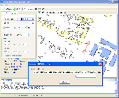
The Gps Generator PRO application is designed for providing assitance in developing, testing and debugging programs and equipment working with the NMEA-0183 protocol. This application can also be used for learning and testing navigation Applications and equipment before purchasing. This virtual Gps receiver can work without visible Gps satellites, thus it's much...
Category: Software Development / Help File Utilities
Publisher: Avangardo, License: Shareware, Price: USD $39.99, File Size: 800.5 KB
Platform: Windows
The leading GPS interface tool for Windows!
The leading Gps interface tool for Windows! Gps answers the significant world demand for accurate, viable and cost effective positioning systems. The Geographic Tracker delivers all of the power and utility of Gps to the Windows environment by allowing you to link a Gps receiver to other Microsoft Windows Applications through standard Windows DDE messaging.
Category: Home & Education / Miscellaneous
Publisher: Bluemarble Geographics, License: Shareware, Price: USD $0.00, File Size: 0
Platform: Windows
Moagu: The Mother Of All GPS Utilities.
Moagu: The Mother Of All Gps Utilities.
You can convert USGS topographic maps, aerial/Satellite imagery, and any other raster map imagery for use on Garmin handled Gps units.
Garmin maps have been in a "vector" format; Moagu creates maps using a "bitmap" format.
Category: Home & Education / Miscellaneous
Publisher: Moagu, License: Shareware, Price: USD $19.95, File Size: 38.2 MB
Platform: Windows
The easiest and most advanced golf Gps unit now available, Sonocaddie V300 with patented color layout.
Using the most advanced Gps Satellite system, Sonocaddie calculates the distance from any point on the course to the green or any other target you choose.
Category: Utilities / Misc. Utilities
Publisher: Sonocaddie V300, License: Shareware, Price: USD $99.00, File Size: 3.6 MB
Platform: Windows
GPS PLUS Collar Manager for your PC is a powerful tool to manage your collars.
Gps PLUS Collar Manager for your PC is a powerful tool to manage your collars. It is designed to communicate with your collars, the UHF/VHF handheld terminal and GSM ground station and is the basic tool to design your study. You can:
- manage collars and GSM/email communication details,
- read out data from collar, handheld terminal and GSM ground station,
- store,...
Category: Home & Education / Miscellaneous
Publisher: VECTRONIC Aerospace GmbH, License: Freeware, Price: USD $0.00, File Size: 8.4 MB
Platform: Windows
Satellite Forms is an ideal tool for business and enterprise developers looking to build custom mobile Applications, or to transform processes typically performed on paper to an electronic format for improved productivity and efficiency. Satellite Forms allows you to create usable, real-world Applications without writing a single line of code. Even more sophisticated...
Category: Business & Finance / Project Management
Publisher: Thacker Network Technologies Inc., License: Shareware, Price: USD $0.00, File Size: 0
Platform: Windows
FREE GPS Software for your Garmin, Magellan or Lowrance GPS.
FREE Gps Software for your Garmin, Magellan or Lowrance Gps.
EasyGPS is the fast and easy way to upload and download waypoints, routes, and tracks between your Windows computer and your Garmin, Magellan, or Lowrance Gps. EasyGPS lists all of your waypoints on the left side of the screen, and shows a plot of your Gps data on the right. Use EasyGPS to back up...
Category: Internet / Communications
Publisher: TopoGrafix, License: Freeware, Price: USD $0.00, File Size: 3.9 MB
Platform: Windows
My Gps Logger 1.01 is a program designed to be used with My Fuel Tax 4.0. With My Gps Logger you can log all the locations where your truck has been to a monthly data file. This data file can later be imported into My Fuel Tax 4.0 by calculating the miles in state using Microsoftâ Mappoint. This is what you will need to use My Gps Logger with My Fuel Tax:a laptop with...
Category: Home & Education / Miscellaneous
Publisher: Spinnaker Software Solutions, License: Freeware, Price: USD $0.00, File Size: 477.7 KB
Platform: Windows
JSatTrak is a Satellite tracking program written in Java.
JSatTrak is a Satellite tracking program written in Java. It allows you to predict the position of any Satellite in real time or in the past or future. It uses advanced SGP4/SDP4 algorithms developed by NASA/NORAD or customizable high precision solvers to propagate Satellite orbits. The program also allows for easy updating of current Satellite tracking data via...
Category: Home & Education / Miscellaneous
Publisher: Shawn Gano, License: Freeware, Price: USD $0.00, File Size: 17.6 MB
Platform: Windows
Gps Tracker Data Logger acts as the server and allows you to collect data from an unlimited number of various Gps trackers simultaneously. The obtained data is processed, uniformed and written to a log file or a database. Also, the program has a set of interfaces so other Applications can get data in real time.
Gps Tracker Data Logger can convert data into...
Category: Internet / Misc. Servers
Publisher: AGG Software, License: Shareware, Price: USD $80.83, File Size: 11.8 MB
Platform: Windows
TopoFusion is a GPS Mapping program for Windows.
TopoFusion is a Gps Mapping program for Windows. It downloads maps (Topo, Aerial Photo and Satellite) automatically from several public map servers.
It seamlessly displays imagery from Terraserver and the OnEarth Server. Maps are downloaded on demand (as the user pans or zooms around the map) and cached on the user's hard drive for faster (and offline) storage.
Category: Utilities / Misc. Utilities
Publisher: TopoFusion, License: Shareware, Price: USD $69.95, File Size: 7.4 MB
Platform: Windows
Tuner4PC allows configuring and establishing internet connection via satellite.
Tuner4PC allows configuring and establishing internet connection via Satellite. Once you have specified all the necessary parameters in the application, Tuner4PC will automatically configure a VPN, OpenVPN, Slonax, Globax, or Sprint link to your provider, depending on your choice.
Main Features:
- Automatic configuration of Satellite Internet connection...
Category: Utilities / Misc. Utilities
Publisher: Skysoftware, License: Shareware, Price: USD $39.99, File Size: 9.6 MB
Platform: Windows
VisualGPSXP is a general purpose utility for monitoring the output of a GPS receiver.
VisualGPSXP is a general purpose utility for monitoring the output of a Gps receiver. Using the NMEA data from the Gps receiver, VisualGPSXP will display various statuses graphically.
Tools such as a survey utility average the position and shows accuracy of the Gps receiver in a static application.
Main features:
- Multiple connection...
Category: Home & Education / Miscellaneous
Publisher: VisualGPC, License: Shareware, Price: USD $25.00, File Size: 1.1 MB
Platform: Windows
Free Satellite Maps is a free tool from Google which offers a satellite mapping service worldwide.
Free Satellite Maps is a free tool from Google which offers a Satellite mapping service worldwide.These are accompanied by a street service, a route planner and information about business in almost all countries.In this way we can fly the world from Satellite view or in birds eye.The level of detail is different depending on where you are located.Major cities have a very...
Category: Home & Education / Science
Publisher: www.satelliteview-of-my-house.com, License: Freeware, Price: USD $0.00, File Size: 612.0 KB
Platform: Windows
Shareware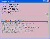
Virtual Gps is a Gps simulator software. You can use it to simulate a Gps receiver unit connected to your system. It's ideal when you need Gps input, but you have no signal or for development purposes. It supports various NMEA sentences, so it can be used with any Gps mapping software. You can use it using a null-modem cable connected to two physical serial...
Category: Internet / RSS & Web Blog Tools
Publisher: Zyl Soft, License: Shareware, Price: USD $39.99, File Size: 856.0 KB
Platform: Windows