Free Downloads: Spatial Display Editor
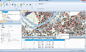
Spatial Workshop is mapping software used for Spatial information integration, query, analysis and reporting.
You build Spatial applications with a few clicks or support complex business processes with geospatial and business data from Oracle, Smallworld, ESRI, maps, files, spreadsheets and other sources.
You can combine and model geospatial data,...
Category: Multimedia & Design / Multimedia App's
Publisher: Spatial Eye bv, License: Freeware, Price: USD $0.00, File Size: 176.7 MB
Platform: Windows
SuperGIS Spatial Statistical Analyst is a set of application software integrating geostatistical methods and GIS functions. Besides exploring of Spatial data, query and demonstrating of attribute data, and the basic statistic capabilities, it also allows users to perform geostatistical analysis to obtain a better understanding about the variance and relativity of Spatial...
Category: Multimedia & Design / Multimedia App's
Publisher: SuperGeo Technologies Inc, License: Demo, Price: USD $0.00, File Size: 3.6 MB
Platform: Windows
The fGIS Editor is a multi-purpose, full-featured, powerful, and easy-to-use GIS application.
The fGIS Editor is a multi-purpose, full-featured, powerful, and easy-to-use GIS application. Created by the same technical expertise behind the popular freeware fGIS program, the fGIS Editor provides a clear, supported upgrade path for current users of fGIS. The fGIS Editor is built upon the TatukGIS Editor and combines the familiar features found in fGIS with the...
Category: Multimedia & Design / Multimedia App's
Publisher: TatukGIS Consulting, License: Shareware, Price: USD $99.00, File Size: 4.8 MB
Platform: Windows
A computer program for the joint analysis of inter-individual spatial and genetic information.
A computer program for the joint analysis of inter-individual Spatial and genetic information. This program performs a variety of Spatial analyses with genetic data including: Mantel Tests, Spatial Autocorrelation Analyses, Allelic Aggregation Index Analyses (AAIA), Mommonier's Algorithm, and "Genetic Landscape Shape" interpolations.
Category: Business & Finance / Applications
Publisher: Mark P. Miller, License: Freeware, Price: USD $0.00, File Size: 4.0 MB
Platform: Windows
SaTScan is a free software that analyzes Spatial, temporal and space-time data using the Spatial, temporal, or space-time scan statistics.
Main features:
- Perform geographical surveillance of disease, to detect Spatial or space-time disease clusters, and to see if they are statistically significant.
- Test whether a disease is randomly distributed over...
Category: Home & Education / Science
Publisher: SaTScan, License: Freeware, Price: USD $0.00, File Size: 10.7 MB
Platform: Windows
Acquiarium is open source software (GPL) for carrying out the common pipeline of many Spatial cell studies using fluorescence microscopy. It addresses image capture, raw image correction, image segmentation, quantification of segmented objects and their Spatial arrangement, volume rendering, and statistical evaluation.
It is focused on quantification of Spatial...
Category: Home & Education / Miscellaneous
Publisher: CBIA, License: Demo, Price: USD $0.00, File Size: 14.8 MB
Platform: Windows
The PDMT Control Point Editor provides tools for creating and modifying control points stored in an APDM or PODS ESRI Spatial geodatabase.
Included are tools for adding control points, graphically modifying a control point location, and adjusting the location/station value of a control point.
Category: Business & Finance / MS Office Addons
Publisher: Eagle Information Mapping. Inc, License: Demo, Price: USD $0.00, File Size: 1.0 MB
Platform: Windows
This is a demo of a forthcoming game in four Spatial dimensions. The game takes place in a world entirely different to everyday experience. As well as left/right, up/down and forward/back, there's another direction in space - the fourth dimension. Objects phase in and out as your craft rotates into this hidden dimension. The game uses an all-new 4D texturing method to Display...
Category: Games
Publisher: Mushware Limited, License: Freeware, Price: USD $0.00, File Size: 5.7 MB
Platform: Windows
Spatial Manager Desktop is a desktop application designed to manage Spatial data in a simple, fast and inexpensive way. Developed by a group of professionals working in the areas of GIS, Planning, Infrastructure and Civil Engineering, it provides the user with powerful tools to address the most common tasks of management and operation in the world of Spatial...
Category: Multimedia & Design / Graphics Viewers
Publisher: Spatial Manager, License: Shareware, Price: USD $149.00, File Size: 114.3 MB
Platform: Windows
You know X-Tools? Grid Machine is X-Tools for grid themes. In ArcViews Spatial Analyst the options to work with grids are very limited, especially if you have requests for multiple grids. Even simple actions (like copy, rename, import, export) are only provided for single grids. Gridmachine offers a lot of helpful tools for the work with ArcView/Spatial Analyst, like the above...
Category: Business & Finance / Database Management
Publisher: ECOGIS Geomatics, License: Shareware, Price: USD $199.00, File Size: 736.2 KB
Platform: Windows
GeoSurveillance is software that combines Spatial statistical routines with some basic Geographic Information Systems (GIS) functions to carry out retrospective and prospective statistical tests for the detection of geographic clustering. In this software, the focus is primarily on the Spatial statistical analysis. Consequently, full GIS functionality is not provided. GIS...
Category: Home & Education / Miscellaneous
Publisher: NCGIA, License: Freeware, Price: USD $0.00, File Size: 2.4 MB
Platform: Windows
Geographic databases management and exploitation, attribute-based and Spatial queries, several join types, several classification methods, thematic cartography, statistics and geo-statistics, Spatial analysis, interpolations, digital elevation models, remote-sensing and image processing, simulation, operational research, interactive metric measurements
Category: Home & Education / Miscellaneous
Publisher: IRD, License: Freeware, Price: USD $0.00, File Size: 14.2 MB
Platform: Windows
WellTracking is an ArcGIS based solution for effective management and visualization of 3D Spatial well drilling data on a corporate level.
The program automates all Spatial data management processes related to the life-cycle of the well allowing monitoring and controlling all stages of the drilling process.
Category: Utilities / Misc. Utilities
Publisher: DataEast, LLC, License: Shareware, Price: USD $3905.06, File Size: 55.4 MB
Platform: Windows
HEC-EFM analyses involve: 1) statistical analyses of relationships between hydrology and ecology, 2) hydraulic modeling, and 3) use of Geographic Information Systems (GIS) to Display results and other relevant Spatial data.
Most features in the main interface of HEC-EFM focus on the first step in this process (statistical analyses). The main interface has four tabs:...
Category: Home & Education / Miscellaneous
Publisher: Hydrologic Engineering Center, License: Freeware, Price: USD $0.00, File Size: 9.0 MB
Platform: Windows
Buffalo is an open source, provider agnostic data spatial delivery platform.
Buffalo is an open source, provider agnostic data Spatial delivery platform.
A loosely coupled, message based Spatial data delivery and analytical platform based on free and open source GIS. The platform abstracts the user from the inherent complexity of the platform and provides a wizard based friendly user interface to setup a Spatial data infrastructure. The...
Category: Business & Finance / Business Finance
Publisher: Data World Pty Ltd, License: Freeware, Price: USD $0.00, File Size: 45.7 MB
Platform: Windows
REFLEX Model Flight Simulator provides a sophisticated stereoscopic 3D mode.
REFLEX Model Flight Simulator provides a sophisticated stereoscopic 3D mode. When activated and observed through appropriate 3D glasses, sceneries and models can be perceived with real Spatial depth. The intuitive perception of distance to ground, to obstacles and to other models offers a substantial additional value.
To make the Spatial depth perceptible on a...
Category: Games / Simulations
Publisher: simWerk, License: Shareware, Price: USD $217.33, File Size: 257.9 MB
Platform: Windows
GeoEFM is used in the Spatial analyses phase of the EFM process to help manage and assess Spatial data layers and to quantify the amount and connectivity of ecological habitats generated by different water management or ecosystem restoration scenarios.
In a GeoEFM project, data layers are organized according to management scenario and ecosystem concern.
Category: Multimedia & Design / Multimedia App's
Publisher: HEC, License: Freeware, Price: USD $0.00, File Size: 23.6 MB
Platform: Windows
MicroCity is a spatial modeling framework for scientific analyses.
MicroCity is a Spatial modeling framework for scientific analyses. You can use and customize it freely under the agreement without paying anything.Extremely small file size and resource consumption.You can easily build your model based on efficient MicroCity Script and run it on the fly. There are enormous extensible modules can be downloaded from web.
Category: Multimedia & Design / Multimedia App's
Publisher: SUN Zhuo, License: Shareware, Price: USD $0.00, File Size: 3.2 MB
Platform: Windows
Military Overlay Editor (MOLE) is a set of COM components for developers to create custom applications that support Department of Defense (DoD) MIL-STD-2525B and the North Atlantic Treaty Organization (NATO) APP6a specifications.
MOLE allows you to easily create, Display, and edit military symbology in your maps. It enhances the effectiveness of your command and control (C2)...
Category: Home & Education / Miscellaneous
Publisher: Environmental Systems Research Institute, Inc., License: Shareware, Price: USD $0.00, File Size: 0
Platform: Windows
PostGIS is unique software that adds support for geographic objects to the PostgreSQL object-relational database.
In effect, PostGIS "spatially enables" the PostgreSQL server, allowing it to be used as a back-end Spatial database for geographic information systems (GIS), much like ESRI's SDE or Oracle's Spatial extension. PostGIS follows the...
Category: Business & Finance / Database Management
Publisher: Refractions Research, License: Shareware, Price: USD $0.00, File Size: 11.2 MB
Platform: Windows
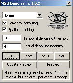
Free high-quality video denoiser plugin for VirtualDub. Easy to use. The filter is designed for noisy video stream processing, video quality improvement, or video preprocessing, e.g. for preprocessing before compression or deinterlacing. Allows flexible denoising level setup in temporal and Spatial dimensions. The filter suppresses noise in both Spatial and temporal domains....
Category: Multimedia & Design
Publisher: Graphics&Media Lab Video Group, License: Freeware, Price: USD $0.00, File Size: 78.7 KB
Platform: Windows
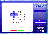
Measure and improve your mental powers in the five key areas: verbal, numerical, logical, Spatial and memory. Use our 40 different exercises to stretch your mind and track your improvement with our daily tests. Progress through the five levels of difficulty in each exercise.
Try it free for 7 days.
Category: Games / Puzzles
Publisher: Oak Systems Leisure Software Ltd, License: Shareware, Price: USD $29.95, File Size: 15.4 MB
Platform: Windows
Driving Model Driven Development .
Driving Model Driven Development . Running under Windows, Blueprint is a modelling tool that will become integral to your software development process. The greatest feature of Blueprint is that it gives you the ability to generate any source code or text based on your model. Experience Model Driven Development now. Extremely large systems have been generated entirely from Blueprint templates...
Category: Utilities / Misc. Utilities
Publisher: Geometry Pty Ltd, License: Freeware, Price: USD $0.00, File Size: 2.0 MB
Platform: Windows
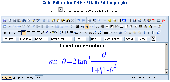
fMath Editor - Cute Editor plugin is the best math editor to create and edit equations on web.
fMath Editor - Cute Editor plugin is the best math Editor to create and edit equations on web. It has more than 20000 symbols to Display and a rich interface. The formula can edited by interface or in MathML or in LaTeX. And is free of charge to use and to distribute.
Category: Home & Education / Mathematics
Publisher: www.fmath.info, License: Freeware, Price: USD $0.00, File Size: 12.1 MB
Platform: Linux, Windows, Mac
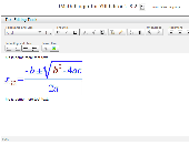
fMath Editor -YUI Editor plugin is the best math editor to create and edit equations on web.
fMath Editor -YUI Editor plugin is the best math Editor to create and edit equations on web. It has more than 20000 symbols to Display and a rich interface. The formula can edited by interface or in MathML or in LaTeX. And is free of charge to use and to distribute.
Category: Home & Education / Mathematics
Publisher: www.fmath.info, License: Freeware, Price: USD $0.00, File Size: 12.1 MB
Platform: Linux, Windows, Mac