Free Downloads: Terrain Modeling
Terrain for Rhino is a terrain modeling plug-in for Rhinoceros (commonly known as Rhino).
Terrain for Rhino is a Terrain Modeling plug-in for Rhinoceros (commonly known as Rhino). This plug-in gives Rhino the ability to create a Terrain mesh from a set of unordered points. The Terrain mesh is created as a Delaunay Triangulation, which is regarded as the best method to create a Terrain mesh from unorganized point data. Terrain for...
Category: Multimedia & Design / Multimedia App's
Publisher: SYCODE, License: Commercial, Price: USD $95.00, File Size: 2.2 MB
Platform: Windows
Terrain for AutoCAD is a terrain modeling plug-in for AutoCAD.
Terrain for AutoCAD is a Terrain Modeling plug-in for AutoCAD. This plug-in gives AutoCAD the ability to create a Terrain mesh from a set of unordered points, lines, polylines and splines. The Terrain mesh is created as a Delaunay Triangulation, which is regarded as the best method to create a Terrain mesh from unorganized point data. Terrain for...
Category: Multimedia & Design / Multimedia App's
Publisher: SYCODE, License: Commercial, Price: USD $195.00, File Size: 2.6 MB
Platform: Windows
Atlas DMT is a graphic interactive system for 3D surface Modeling and visualization, featuring a special focus on Terrain Modeling.
Atlas DMT can process elevation data (points, breaklines) from various sources - e.g., total stations, photogrammetry, digitized maps, proprietary formats (Kokes, Topol, Hydroinform) or text files (imported or prepared manually).
Category: Multimedia & Design / Image Editing
Publisher: Atlas, spol. s r. o., License: Shareware, Price: USD $0.00, File Size: 0
Platform: Windows
Introducing you AEC Terrain interface which is designed to simplify Terrain management and 3D-Modeling. AEC Terrain creates Digital Elevation Model from multiple input point files on AutoCAD graphic editor. All purpose multi-level pads, road alignments, mining applications and airfields can be generated on the Terrain on different layers with different slope...
Category: Business & Finance / Project Management
Publisher: AEC Logic Private Limited, License: Shareware, Price: USD $750.00, File Size: 16.3 MB
Platform: Windows
Terrain Generator Terrain Generator allows you to generate terrain for specific games.
Terrain Generator Terrain Generator allows you to generate Terrain for specific games. You can specify almost everything when it's about creating a Terrain which then later can be used aside textures for a beautiful product. The program can export to different file formats for easy integration.
Category: Games / Tools & Editors
Publisher: Ryan Gregg, License: Freeware, Price: USD $0.00, File Size: 522.8 KB
Platform: Windows

Visual Terrain Maker is a 3D-Modeling program allows visually create landscapes (maps) for games or other purposes. Works in XP/NT/2k. The program can export to Direct X file format(*.x). The program is not critical to the video adapters and drivers. Suitable for Dark Basic developers. No special software and hardware required (just OpenGL v1.1). Visual Terrain Maker can...
Category: Multimedia & Design
Publisher: UNGSoft Developers Group, License: Freeware, Price: USD $0.00, File Size: 321.2 KB
Platform: Windows
UK Based Civil Engineering and Surveyor Software Developers, covering all aspects of surveying and engineering including digital Terrain Modeling.
- Reduce Traverse and Resection Observations?
- Reduce Field Observations?
- Reduce Levels?
- Compute Least Squares Solutions
Category: Home & Education / Miscellaneous
Publisher: NRG Surveys, License: Shareware, Price: USD $161.00, File Size: 17.6 MB
Platform: Windows
With this FREE AutoCAD add-on you can create Terrain sections
from geodetic points(heights) in the drawing. You can also
specify position of pipe(cable, road, ...) or set auxiliary
marks in the section.
Text settings, scale in X,Y axis, height of the reference
plane and type of the Terrain section can be set at start-up.
There are two ways how you can create...
Category: Multimedia & Design / Multimedia App's
Publisher: Cadhedral, License: Freeware, Price: USD $0.00, File Size: 69.0 KB
Platform: Windows
While the Terrain that ships out-of-the-box with FSX is much-improved over previous versions, the newly-enhanced Terrain engine still leaves much vacant capabilities to fill. So FSGenesis has bumped it up a notch, filling those capabilities while providing our most accurate and detailed Terrain yet, taking advantage of the efficiency of the new all-LODs-in-one-file format...
Category: Home & Education / Miscellaneous
Publisher: FSGenesis, License: Freeware, Price: USD $0.00, File Size: 28.0 MB
Platform: Windows
Surfer software is a full-function 3D visualization, contouring and surface modeling package.
Surfer software is a full-function 3D visualization, contouring and surface Modeling package. Surfer is used extensively for Terrain Modeling, landscape visualization, surface analysis, contour mapping, 3D surface mapping, gridding, volumetrics, and much more.
Category: Multimedia & Design / Image Editing
Publisher: Golden Software, License: Shareware, Price: USD $699.00, File Size: 42.8 MB
Platform: Windows
 Shareware
Google Maps Terrain Downloader is a tool that can automatically download the google Terrain maps images to your PC. It can download the small tiles and save them to your hard disk. After downloading, you can view the maps offline by its tool Maps Viewer, or you can combine the small images into one big map image. If you want to make a map of your city by yourself, it is very...
Category: Internet / Download Managers
Publisher: allmapsoft.com, License: Shareware, Price: USD $29.99, File Size: 305.3 MB
Platform: Windows
Terrain Tools - Create maps quickly and easily!
Terrain Tools - Create maps quickly and easily!
Terrain Tools is the ideal tool for outdoor recreationists, real-estate professionals, farmers, ecologists, archaeologists and others who need to create basic maps, calculate areas, lengths, bearings and distances.
Overlay GPS tracks on scanned images such as USGS or Canadian NTS topos. Import and export...
Category: Business & Finance / Applications
Publisher: Softree, License: Shareware, Price: USD $124.00, File Size: 15.0 MB
Platform: Windows
Oriantica is the new generation orienteering simulation software.
Oriantica is the new generation orienteering simulation software. Using a map and a compass you have to find your way through the Terrain to locate the controls as fast as possible.
In Oriantica it is possible to compete with other players over a network, or play against the computer.
The map and Terrain is much more flexible than in previous versions, with more...
Category: Games / Misc. Games
Publisher: Melin Software HB, License: Shareware, Price: USD $39.00, File Size: 16.5 MB
Platform: Windows
SC3K Map Editor is the fastest and most accurate Terrain editor currently available for SimCity 3000. It gives you the finest possible control over modifications to your Terrain.
With SC3K Map Editor you can use an interface very similar to that given by SimCity 3000 so that you can see exactly what your Terrain will look like as you create it.
Also you...
Category: Games / Tools & Editors
Publisher: Tenermerx Software, License: Freeware, Price: USD $0.00, File Size: 990.5 KB
Platform: Windows
FSGenesis is your one-stop supplier for top-quality terrain mesh products for FS2004 and FSX.
FSGenesis is your one-stop supplier for top-quality Terrain mesh products for FS2004 and FSX. Since 1996 we have provided the world-wide flight simulator community with high-quality products at a low price. If you're looking for Terrain mesh for Microsoft Flight Simulator, look no further.
Category: Games / Simulations
Publisher: FSGenesis, License: Freeware, Price: USD $0.00, File Size: 116.0 MB
Platform: Windows
SpaceClaim already has the ability to export to 3DM files.
SpaceClaim already has the ability to export to 3DM files. Solid objects in SpaceClaim are converted into solid objects in 3DM files. SpaceClaim does not offer an option to convert solids into polygon meshes in a 3DM file. The 3DM file format is an open format used by many applications to store polygon mesh data, such as TerrainCAD, our Terrain mesh Modeling software. Such...
Category: Multimedia & Design / Multimedia App's
Publisher: SYCODE, License: Commercial, Price: USD $195.00, File Size: 2.8 MB
Platform: Windows
Creeper World 2 thrusts you into the 14th millennium fighting an enemy that flows and oozes through the Terrain. Employ advanced weapons, gravity manipulating repulsors, wormhole like rifts, and your own wit against this never yielding enemy.
Excavate Terrain, unearth techs, crystals, remnants and other artifacts. Face a new mechanical enemy that employs gravity manipulation...
Category: Games / Kids
Publisher: Knuckle Cracker, LLC, License: Shareware, Price: USD $9.95, File Size: 30.1 MB
Platform: Windows
Freeworld3D 2.4 is a fully interactive real-time 3D Terrain editor and world editor specifically designed for game development. FreeWorld3D gives you the ability to produce complete 3D Terrain, worlds and environments in a matter of no time. FreeWorld3D's ease of use and intuitive interface makes it extremely easy to use.
Category: Games / Tools & Editors
Publisher: Pariman, License: Freeware, Price: USD $0.00, File Size: 5.2 MB
Platform: Windows
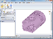
JointMetriX3D is an innovative system for measuring and assessing rock and Terrain surfaces used in geotechnics, engineering geology, and surveying. It delivers outstanding detailed 3D images and provides 3D software for getting measurements.
The system has significant influence on safety when applied in tunnelling, mining, Terrain assessments, or various documentation...
Category: Software Development / Help File Utilities
Publisher: 3GSM, License: Demo, Price: USD $0.00, File Size: 2.3 KB
Platform: Windows
Overview of Purpose: T.Ed is a complete solution for making huge outdoor worlds: The technique behind designing and using Terrain objects can be a minefield of choices, as there are so many different ways of doing it! T.Ed is designed primarily for games programmers and 3D artists to make those choices easier. There are 2 main categories regarding terrains in games, 'Mesh' and...
Category: Multimedia & Design
Publisher: D-Grafix, License: Freeware, Price: USD $0.00, File Size: 7.6 MB
Platform: Windows
Panorama is a terrain or landscape editor, where beautiful multitextured landscapes are made easy.
Panorama is a Terrain or landscape editor, where beautiful multitextured landscapes are made easy. Landscapes can be created, painted, lightmapped and exported. The program features: Easy to use windows interface Create nice looking terrains in no time Up to 8x8 64x64 segments terrains (huge terrains) Currently exports to Blitz3D (.b3d), Directx (.x) and Wavefront (.obj) formats Add any...
Category: Games / Tools & Editors
Publisher: Jeppe Nielsen, License: Shareware, Price: USD $24.00, File Size: 4.6 MB
Platform: Windows
The General Algebraic Modeling System (GAMS) is a high-level Modeling system for mathematical programming and optimization. It consists of a language compiler and a stable of integrated high-performance solvers. GAMS is tailored for complex, large scale Modeling applications, and allows you to build large maintainable models that can be adapted quickly to new situations.
Category: Multimedia & Design / Digital Media Editors
Publisher: GAMS Development, License: Shareware, Price: USD $0.00, File Size: 67.7 MB
Platform: Windows
CityEngine is a standalone software that provides professional users in entertainment, architecture, urban planning, GIS and general 3D content production with a unique conceptual design and Modeling solution for the efficient creation of 3D cities and buildings.
CityEngine offers unique street grow tools to quickly design and construct urban layouts. Street patterns such as...
Category: Business & Finance / Business Finance
Publisher: Procedural Inc., License: Shareware, Price: USD $299.00, File Size: 40.2 MB
Platform: Windows
ProJob is a free software utility supplied by Prolec for use with Digital Terrain Maps (DTM).
ProJob is a free software utility supplied by Prolec for use with Digital Terrain Maps (DTM). Its principle function is to take one of the many standard industry formats for these DTMs and convert it into a .tri file. A .tri file is the proprietary format used by Prolec's Digmaster Pro machine control product, and because of the way that Digmaster Pro and ProJob work together, very...
Category: Multimedia & Design / Graphics Viewers
Publisher: Prolec Ltd, License: Freeware, Price: USD $0.00, File Size: 3.5 MB
Platform: Windows
Quantrix Modeler Professional Edition is a business Modeling and analytics solution that offers unmatched capability for forecasting, planning, budgeting, data Modeling, risk Modeling and more. With robust presentation capabilities, it is a great solution for developing and presenting models to colleagues, clients and executive decision-makers.
Category: Business & Finance / Business Finance
Publisher: Quantrix, License: Shareware, Price: USD $1549.00, File Size: 677.1 MB
Platform: Windows