Free Downloads: Topography
The MapMart On-Demand™ toolbar enables a user to access aerial, satellite, DEM, Topography and vector data from within the ArcMap application. Once a user installs the plug-in within ESRI ArcMap 9.2 or 9.3, users will be able to research, preview, purchase and download imagery and data for their projects inside ArcMap
Category: Software Development / Misc. Programming
Publisher: MapMart, License: Freeware, Price: USD $0.00, File Size: 954.8 KB
Platform: Windows
WinPilot 3D is flight analysis and planning software, that lets you zoom in from satellite altitude into any place on Earth, leveraging Landsat satellite imagery and Shuttle Radar Topography Mission elevation data. WinPilot 3D lets you experience Earth terrain in visually rich 3D, just as if you were really there. WinPilot 3D also shows airspace in 3D, and contains world-wide database of...
Category: Home & Education / Miscellaneous
Publisher: WinPilot, License: Shareware, Price: USD $59.00, File Size: 3.8 MB
Platform: Windows
 Freeware
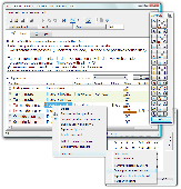
Teach2000 is a private teacher to help you memorize a foreign language, Topography or even the history of Italy by dates. Improve your school results with this free language trainer. Many ways of testing. Examples. Two or more different answers possible. Multi-line questions/answers. Full Unicode support, ancient Greek font included. Dictionaries included. Easy input of special symbols....
Category: Home & Education / Language
Publisher: basement.nl, License: Freeware, Price: USD $0.00, File Size: 7.2 MB
Platform: Windows
Shareware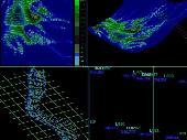
AutoLISP source code can be run on AutoCAD or IntelliCAD (Bricscad, ProgeCAD, Cadopia, etc.), on any number of computers. There are 6 programs for: - "Triangulation" will generate triangular 3DFACE entities, on the convex hull of the set of points, - "Load XYZ and 4D files"; file types: x y z color, x y z scalar, x y z r g b, no. x y z code, - "B-spline control polygon and interpolated...
Category: Multimedia & Design / Graphics Viewers
Publisher: Rcad Software, License: Shareware, Price: USD $100.00, File Size: 1.4 MB
Platform: Windows
SWAN is the most widely used computer model to compute irregular waves in coastal environments, based on deep water wave conditions, wind, bottom Topography, currents and tides (deep and shallow water). SWAN explicitly accounts for all relevant processes of propagation, generation by wind, interactions between the waves and decay by breaking and bottom friction. Diffraction is included...
Category: Business & Finance / Applications
Publisher: Digital Hydraulics Holland BV, License: Shareware, Price: USD $319.67, File Size: 4.3 MB
Platform: Windows
World Wind lets you zoom from satellite altitude into any place on Earth.
World Wind lets you zoom from satellite altitude into any place on Earth. Leveraging Landsat satellite imagery and Shuttle Radar Topography Mission data, World Wind lets you experience Earth terrain in visually rich 3D, just as if you were really there. V
Category: Home & Education / Mathematics
Publisher: worldwind.arc.nasa.gov, License: Freeware, Price: USD $0.00, File Size: 16.0 MB
Platform: Windows
Ra2dTomo is a tool for 2d refraction tomography.
Ra2dTomo is a tool for 2d refraction tomography. It is able to incorporate arbitrary surface Topography by the use of unstructured triangle meshs. It reads several formats (reflex, gremix, tom and own formats) and allows the user to specify depth and fineness of the model. Usually a gradient type starting model is applied to enable ray coverage. Several inversion options can be chosen as...
Category: Home & Education / Miscellaneous
Publisher: resistivity.net productions, License: Freeware, Price: USD $0.00, File Size: 5.4 MB
Platform: Windows
HydroSHEDS is a mapping product that provides hydrographic information for regional and global-scale applications in a consistent format. It offers a suite of geo-referenced data sets (vector and raster) at various scales, including river networks, watershed boundaries, drainage directions, and flow accumulations. HydroSHEDS is based on high-resolution elevation data obtained during a Space...
Category: Home & Education / Miscellaneous
Publisher: WWF-CSP, License: Freeware, Price: USD $0.00, File Size: 1.7 MB
Platform: Windows
Trimble Optical Positioning Communication Components is a very useful tool, easy to install and easy to manipulate. This program was designed for the Trimble® RTS Series Robotic Total Stations which offer construction-specific functionality and one-person operation so you can perform all jobsite layout and measurement tasks for maximum flexibility and cost savings. The Trimble Optical...
Category: Utilities / Misc. Utilities
Publisher: Trimble AB, License: Freeware, Price: USD $0.00, File Size: 42.2 MB
Platform: Windows
Building on top of OSSIM and OpenSceneGraph capabilities, ossimPlanet is a rapidly evolving project for accurate, high performance, 3D Geo-spatial visualization.
It automatically intersects with DTED and/or SRTM elevation trees for Topography and handles a wide range of commercial and government file formats natively.
Additionally, remote layers can be...
Category: Multimedia & Design / Multimedia App's
Publisher: OSSIM, License: Shareware, Price: USD $0.00, File Size: 995.4 MB
Platform: Windows
The program CONEFALL is designed to estimate roughly the potential rock falls prone area.
The program CONEFALL is designed to estimate roughly the potential rock falls prone area.
The principle of the program is rather simple. A block can propagate if the slope is sufficiently steep. Physically consider that if the slope is steeper than a limit jp, then the block accelerates. If it is lower, it decelerates.
Using the previous assumption, a block can propagate from...
Category: Business & Finance / Applications
Publisher: Quanterra, License: Freeware, Price: USD $0.00, File Size: 2.2 MB
Platform: Windows
InterpOSe for Digimap is designed to process the data delivered as part of EDINA's new OS MasterMap service for Academic Organisations within the UK. It handles both the Topography and ITN layers of OS MasterMap for conversion to various file formats, including Shape, TAB, mid/mif and DWG/DXF.
The InterpOSe for Digimap edition can slice OS MasterMap data into tiles,...
Category: Business & Finance / Business Finance
Publisher: Dotted Eyes, License: Freeware, Price: USD $0.00, File Size: 65.5 MB
Platform: Windows
CityEngine is a standalone software that provides professional users in entertainment, architecture, urban planning, GIS and general 3D content production with a unique conceptual design and modeling solution for the efficient creation of 3D cities and buildings.
CityEngine offers unique street grow tools to quickly design and construct urban layouts. Street patterns such as grid,...
Category: Business & Finance / Business Finance
Publisher: Procedural Inc., License: Shareware, Price: USD $299.00, File Size: 40.2 MB
Platform: Windows
Shareware
GPS Mapping Software for Windows, Loading topographic maps, realtime navigation, track recording, manage GPS devices and more. The software can be used with various map formats including: GeoTiff, BSB Nautical Charts, AutoCad DXF files, ESRI Shapefiles. Using calibration you can also use scanned or downloaded JPG, BMP, GIF, PNG and TIF maps. The software can be used for survey, research, track...
Category: Home & Education / Science
Publisher: Eye4Software B.V., License: Shareware, Price: USD $149.00, EUR99, File Size: 11.1 MB
Platform: Windows
TRIANGULATION, ISOLINES, VOLUME and 3DINTERSECTION; 4 functions for IntelliCAD
TRIANGULATION performs triangulation of a set of 3D points width compulsory interconnections between the points. The outcome is represented by 3DFACE entities. ISOLINES determines the curves of intersection of a set of 3DFACE entities width a set of plane equidistances horizontally or vertically. The outcome is made up of POLYLINE entities optionally interpolated. VOLUME determines volume and...
Category: Multimedia & Design
Publisher: Rcad Software, License: Shareware, Price: USD $49.00, File Size: 359.6 KB
Platform: Windows
The PROSYS II software is a program allowing to transfer, edit, process and export resistivity and
chargeability data of the IRIS Instruments resistivity-meters (SYSCAL) and IP receivers (ELREC).
Main features:
-Data download
- Numeric and graphic presentation (raw parameters, resistivity, chargeability,…)
- Processing (filter on threshold...
Category: Business & Finance / Applications
Publisher: IRIS instruments, License: Freeware, Price: USD $0.00, File Size: 15.6 MB
Platform: Windows
Method 1 - Simplified Method for Low-rise Buildings (MWFRS and Components & Cladding).
Method 1 - Simplified Method for Low-rise Buildings (MWFRS and Components & Cladding).
Method 2 - Analytical Procedure for Buildings of All Heights (MWFRS, Components & Cladding), Open Buildings, Freestanding Walls & Signs and Other Structures.
Adjustments for Mean Sea Level, Importance Factor, Topography, and Exposure Category are made...
Category: Home & Education / Miscellaneous
Publisher: Digital Canal Corporation, License: Shareware, Price: USD $0.00, File Size: 0
Platform: Windows
Potent is a Windows application that provides a highly interactive framework for 3-D modelling of magnetic and gravity data.
This example uses one of Geosoft's Oasis montaj sample datasets. The top left window shows the entire TMI dataset as a grid. The bottom left window shows the subset of data around the two anomalies of interest. The top right window shows an ENE section...
Category: Multimedia & Design / Multimedia App's
Publisher: Geophysical Software Solutions Pty. Ltd., License: Shareware, Price: USD $750.00, File Size: 8.5 MB
Platform: Windows
Shareware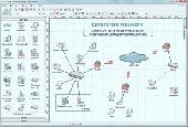
Create network maps with this powerful network diagrammer. Draw a LAN topology.
10-Strike Network Diagram is a powerful network diagrammer and mapper for the quick creation of visual local-area network maps and diagrams, and exporting them to Microsoft Visio, or saving as charts, vector, or raster images. The program will scan your managed switches via SNMP and discover the LAN topology automatically. It supports scanning via the ICMP, TCP, UPnP, SNMP, and LLDP...
Category: Software Development / Databases & Networks
Publisher: 10-Strike Software, License: Shareware, Price: USD $149.95, RUB3990, File Size: 5.3 MB
Platform: Windows
FlamMap is a fire behavior mapping and analysis program that computes potential fire behavior characteristics (spread rate, flame length, fireline intensity, etc.) over an entire FARSITE landscape for constant weather and fuel moisture conditions. For more information, look under National Systems in the menu at the top of each page.
The FlamMap software creates raster maps of...
Category: Business & Finance / Business Finance
Publisher: SEM, License: Freeware, Price: USD $0.00, File Size: 6.2 MB
Platform: Windows
SurfMate is a digital terrain modelling and earthworks design solution giving the designer many enhanced features for use in Digital Terrain Modelling and Earthworks design completely integrated with AutoCAD.
TECHNoCAD have put great effort into packing as many useful options as possible into the software to make it the most valuable add-on to AutoCAD available to the DTM modeller...
Category: Multimedia & Design / Image Editing
Publisher: TECHNoCAD, License: Demo, Price: USD $0.00, File Size: 78.5 MB
Platform: Windows
A volume of data with map names, map numbers, corner coordinates and completing data of all official topographic maps of the Federal Republic of Germany. TK25: Data base table with data of the maps on a scale 1:25000. TK50: Table with data of the maps on a scale 1:50000. TK100: Table with data of the maps on a scale 1:100000. TK200: Table with data of the maps on a scale 1:200000 (TKUe200,...
Category: Business & Finance
Publisher: Killet Software Ing.-GbR, License: Demo, Price: USD $30.00, File Size: 29.3 KB
Platform: Windows, Linux, Unix, MS-DOS, Not Applicable
Shareware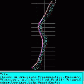
An add-on for AUTOCAD or BricsCAD, which makes the triangulation of a set of POINT entities, the intersection curves (isolines) between a set of 3DFACE entities and a set of equidistance plans, horizontally or vertically and the volume and center of gravity of a set of bodies or between surfaces composed of 3DFACE entities. You can also load and draw a file of points having the format: Number...
Category: Multimedia & Design / Graphics Viewers
Publisher: Rcad Software, License: Shareware, Price: USD $64.00, EUR59, File Size: 2.5 MB
Platform: Windows
Shareware
TOPOWIN is a state-wide register of the German Topographic Cartographies, the German Basic Cartography and of localities with geo references in different coordinate systems. It is also a topographic information system. In the division of planning and execution of economical and scientific projects frequently topographic documents are used. The program TOPOWIN makes information available of the...
Category: Home & Education / Miscellaneous
Publisher: Killet GeoSoftware Ing.-GbR, License: Shareware, Price: USD $125.00, EUR110, File Size: 4.5 MB
Platform: Windows
World Wind lets PC users zoom from satellite altitude into any place on the globe.
World Wind lets PC users zoom from satellite altitude into any place on the globe. Leveraging Landsat satellite imagery and Shuttle Radar Topography Mission data, World Wind lets you experience Earth terrain in visually rich 3D, just as if you were really there. Virtually visit any place in the world. Look across the Andes, into the Grand Canyon, over the Alps, or along the African...
Category: Home & Education / Science
Publisher: NASA, License: Freeware, Price: USD $0.00, File Size: 15.0 MB
Platform: Windows, 2K