Free Downloads: Geo Satellite Locations
License: All | Free
The Orbit Visualization Tool (OVT) is a software for visualization of Satellite orbits in the Earth's magnetic field. The program can display Satellite orbits in five coordinate systems (GEI, Geo, GSM, SMC, GSE), Satellite footprints projected on the Earth's surface and shown in either geographic (Geo) or geomagnetic (SMC) coordinates. In addition to...
Category: Home & Education / Astrology & Numerology
Publisher: OVT Team, License: Freeware, Price: USD $0.00, File Size: 0
Platform: Windows
Instant QR Codes is able to generate QR codes for web url addresses, email, Geo Locations, phone numbers, contact cards, me-cards, wifi configuration and even Android Marketplace. The best part is that the program does not need a active Internet connection, it is totally self-contained.
Category: Utilities / Misc. Utilities
Publisher: JettDigitals, License: Freeware, Price: USD $0.00, File Size: 2.5 MB
Platform: Windows
JSatTrak is a Satellite tracking program written in Java.
JSatTrak is a Satellite tracking program written in Java. It allows you to predict the position of any Satellite in real time or in the past or future. It uses advanced SGP4/SDP4 algorithms developed by NASA/NORAD or customizable high precision solvers to propagate Satellite orbits. The program also allows for easy updating of current Satellite tracking data via...
Category: Home & Education / Miscellaneous
Publisher: Shawn Gano, License: Freeware, Price: USD $0.00, File Size: 17.6 MB
Platform: Windows
Free Satellite Maps is a free tool from Google which offers a satellite mapping service worldwide.
Free Satellite Maps is a free tool from Google which offers a Satellite mapping service worldwide.These are accompanied by a street service, a route planner and information about business in almost all countries.In this way we can fly the world from Satellite view or in birds eye.The level of detail is different depending on where you are located.Major cities have a very...
Category: Home & Education / Science
Publisher: www.satelliteview-of-my-house.com, License: Freeware, Price: USD $0.00, File Size: 612.0 KB
Platform: Windows
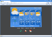
AniWeather animates weather in vivid animations for worldwide locations worldwide.
AniWeather animates weather in vivid animations for worldwide Locations worldwide. It switches different Locations in one click. Aniweather provides flexible weather reports, from real time current condition, radar/Satellite map, to 5-day forecast, and to more detailed hourly report. It is quite customizable to fit your preference (temperature unit, location list, animation...
Category: Internet / Browsers
Publisher: AniWeather, License: Freeware, Price: USD $0.00, File Size: 101.0 KB
Platform: Windows
The EQMODLX is a LX200 Emulator program that accepts Satellite tracking issued by a LX200 Compatible Satellite Tracking Software.This configuration allows you to track the Satellite continuously instead of the the "Leap Frog" fashion as made available to the old nextstar protocol.This software application can also converts the Satellite tracks to EQ custom...
Category: Home & Education / Astrology & Numerology
Publisher: chrisshillito, eqmodarchie, sarmientomon, License: Freeware, Price: USD $0.00, File Size: 354.2 KB
Platform: Windows
Satellite earth is a software for viewing satellite and aerial imagery of the Earth.
Satellite earth is a software for viewing Satellite and aerial imagery of the Earth.Satellite Earth allows you to enjoy virtual travel around the world, look up local information and plan trips, exploring multimedia content and share information about your trips.Explore towns, cities and terrain relief shown in three-dimensional images of high resolution associated with...
Category: Home & Education / Science
Publisher: www.satelliteview-of-my-house.com, License: Freeware, Price: USD $0.00, File Size: 584.0 KB
Platform: Windows
When posting a photo on your favorite Social Network, online photo gallery, or web page, you are inviting danger.Most smartphones and some cameras made today are equipped with Geo tags. Geo tags are imbedded in the picture and use the same concept as GPS.
The Geo tag in the photo is a smart tool that allows the photo to be tagged to an exact location. Unless you know...
Category: Security & Privacy / Other
Publisher: Geotag Security Software, Inc, License: Freeware, Price: USD $0.00, File Size: 2.2 MB
Platform: Windows
Create the GeoDatabase for the entire world. This program create the geographical location Latitude, Longitude, and Altitude (Elevation) for every city, village, region, state, county in the World. The program crawls the data from the website www.heavens-above.com which collect data from US Geological Survey for the USA (and dependencies) and The National Imaging and Mapping Agency for all...
Category: Software Development
Publisher: Mewsoft, License: Freeware, Price: USD $0.00, File Size: 1.1 MB
Platform: Windows
The Balloon Browser recognizes and highlights geo-coordinates in web pages.
The Balloon Browser recognizes and highlights Geo-coordinates in web pages. Hovering over a recognized location advises another application to show a map of the corresponding area. For now the only program Balloon Browser can interact with is Google Earth.
Instead of waiting for the one true Geo-notation and markup standard, Balloon Browser tries to parse a variety of...
Category: Internet / Browsers
Publisher: Michael Krause, License: Freeware, Price: USD $0.00, File Size: 5.6 MB
Platform: Windows
Live Satellite Maps or Google maps is a web server mapping applications.
Live Satellite Maps or Google maps is a web server mapping applications.Provides scrolling map images and Satellite photos around the earth and even the route between different places.Since 6 October 2005, live Satellite Maps is part of local Google.Google live Satellite Map provides the ability to zoom in or zoom out to show the map.The user can control the map with...
Category: Home & Education / Science
Publisher: www.satelliteview-of-my-house.com, License: Freeware, Price: USD $0.00, File Size: 643.0 KB
Platform: Windows

Dishnetwork Deals Dish Satellite TV.
Dishnetwork Deals Dish Satellite TV. Dish Network Discounts. Dish Network TV Deals! Dish Network Television Deals and Free Offers! DISH Network installation and service nationwide. Satellite TV systems from Profressional Dealers. Free Dishnet receivers and DVR systems. Satelite Television, DISH, Digital TV, Broadband Internet, HD and DirectTV free satlite deals available. Order...
Category: Internet / Browsers
Publisher: Dishnetwork Deals, License: Freeware, Price: USD $0.00, File Size: 1.5 MB
Platform: Windows
Can you imagine how large an Satellite image is, which has dimensions of 86400 pixels wide and 43200 pixels high?This is a simple article which describes the Worlds Largest Satellite Images.See the largest Satellite images using a free software which is included inside.This free software will enables you to see Satellite images of the entire earth for free.
Category: Home & Education / Miscellaneous
Publisher: www.satelliteimage-of-my-house.com, License: Freeware, Price: USD $0.00, File Size: 590.0 KB
Platform: Windows
Orbitron 3.71is a Satellite tracking system for radio amateur and observing purposes.
The program can be also used by weather professionals, Satellite communication users, astronomers, UFO hobbyist and astrologers.
The program shows the positions of satellites at any moment (in real or simulated time).
Orbitron 3.71 can be installed in 35...
Category: Internet / Communications
Publisher: Sebastian Stoff, License: Freeware, Price: USD $0.00, File Size: 2.0 MB
Platform: Windows
View amazing satellite images of earth with the free version of google earth software.
View amazing Satellite images of earth with the free version of google earth software.Google earth is a totally free software which enables you zoom in from Satellite,view,rotate or tilt just like a camera of the entire earth inside your pc.It works just point and click on any part of earth or by typing addrees name of city or country and google earth will down from space to the...
Category: Home & Education / Miscellaneous
Publisher: www.satelliteimage-of-my-house.com, License: Freeware, Price: USD $0.00, File Size: 798.0 KB
Platform: Windows

Ready to start saving? It's never been a better time to switch to Satellite Television then now. You won't find better Dish Network deals available any where else on the internet.
If you've been throwing away your money on cable tv or DirecTV then you've come to the right place.
Order now
Save with special web only promotions! We are a high volume Satellite tv system...
Category: Internet / Browsers
Publisher: Dish Network Channel Packages, License: Freeware, Price: USD $0.00, File Size: 1.6 MB
Platform: Windows, Linux, Mac
ZenVPN routes all your Internet traffic via an encrypted tunnel to a remote server allowing you to - Bypass any website blocks enacted by your government or network operator - Access Geo-restricted services such as TV streaming - Protect your connection from snooping - Protect your identity by concealing your real IP address from the sites you visit - Escape traffic logging...
Category: Internet / Online Privacy
Publisher: Liberconnect Inc., License: Freeware, Price: USD $0.00, File Size: 10.0 MB
Platform: Windows
 Freeware
DreamBoxTools - a program for tuning your DreamBox Satellite receiver. Control your receiver right from the computer. Main features: - Lyngsat-to-Dreambox transponders parser. Update data about satellites and transponders to your receiver directly from the site Lyngsat.com - Satellite filter - Europe, Asia, Atlantic, America, only HD, manual choice, saved...
Category: DVD & Video / Video Conversion
Publisher: Protectedsoft Ltd., License: Freeware, Price: USD $0.00, File Size: 1014.4 KB
Platform: Windows
Immageo is all about making your photos as memorable as when you took them, by geotagging each photo. Immageo is a truly exciting example of what you can and should do with your photo collections. Its more than an album organiser, it embeds map Locations and notes into your photos. And when you come to review them Immageo displays them all in context of when and where in the Immageo map,...
Category: Multimedia & Design / Media Catalogers
Publisher: Immageo, License: Freeware, Price: USD $0.00, File Size: 11.0 MB
Platform: Windows
Satellite Finder is a way to accurately point satellite dishes at communications satellites in geostationary orbit.
Category: Home & Education / Mathematics
Publisher: arachnoid.com, License: Freeware, Price: USD $0.00, File Size: 1.4 MB
Platform: Windows, Mac, 2K
TerraClient allows viewing and printing of ground level satellite photographs of the United States.
TerraClient allows viewing and printing of ground level Satellite photographs of the United States. Featured is a unique map overlay option that automatically superimposes a "paper" roadmap over the Satellite photos. This map overlay option has been designed to help users identify indistinct land features in the Satellite photos. All map and photographic data is...
Category: Home & Education / Miscellaneous
Publisher: Bill Friedrich Software, License: Freeware, Price: USD $0.00, File Size: 1.3 MB
Platform: Windows
DESA Satellite Tracker allows you to track the International Space Station and other satellites in real time. The built in radar alarm will alert you to satellites that would be visible to you and let you know where to look (although you will only be able to actually see the satellites an hour before sunrise and an hour after sunset).
DESA Satellite Tracker is 100% free
Category: Home & Education / Astrology & Numerology
Publisher: red diligence, License: Freeware, Price: USD $0.00, File Size: 977.8 KB
Platform: Windows
Whether you need accurate data for GIS applications or visual simulation applications, GeoGenesis provides you the ability to exploit commercial Satellite or aerial imagery to meet your requirements. For aerial or Satellite imagery, GeoGenesis provides advanced automated tie point extraction to geospatially link multiple images together. Using our bundle adjustment algorithm you...
Category: Home & Education / Miscellaneous
Publisher: IAVO Research And Scientific, License: Freeware, Price: USD $0.00, File Size: 73.9 MB
Platform: Windows
Put in multiple station Locations to determine the best time to observe these stations simultaneously.
Get detailed sky plots (including obstructions) of your site for any time of the day to aid in determining the best available occupation times.
Chart out the different DOP values by time.
Get a quick overview on the number of satellites available...
Category: Internet / Communications
Publisher: Trimble Navigation Limited, License: Freeware, Price: USD $0.00, File Size: 23.4 MB
Platform: Windows
The AMGtime app allows employers to track their employees movements on the go and at remote Locations, with notifications for every transaction. Managers Can: - Check the Status Board on their smartphone for real-time data on employee location, punches, and time worked - View absence/presence summaries - Ensure constant communication with their mobile workforce Employees Can:...
Category: Business & Finance / Applications
Publisher: AMG Employee Management, License: Freeware, Price: USD $0.00, File Size: 34.0 MB
Platform:
This is a very easy to use desktop application that will alert you whenever new articles are added to Portable Satellite Radio.com. Simply install the software and any time new content is added to the website, you will receive an alert on your desktop letting you know, and showing you part of the article. If you are interested and want to read the rest of the article, simply click on the...
Category: Desktop Enhancements / Misc. Themes
Publisher: Portable Satellite Radio, License: Freeware, Price: USD $0.00, File Size: 656.0 KB
Platform: Windows
Satellite Free VST is a free and exclusive VST/AU/RTAS Plug-In Instrument.
Satellite Free VST is a free and exclusive VST/AU/RTAS Plug-In Instrument. It's multi-timbral, has great filters, effects and a built-in mixer.
Use it in your DAW (Logic, Cubase,Pro Tools, Live, etc) to play the sounds you downloaded.
It's easy to download and simple to install.
Category: Audio / Music Creation
Publisher: Samplebase, License: Freeware, Price: USD $0.00, File Size: 1.1 MB
Platform: Windows

Dish Network Discounts. Dish Network TV Deals! Dish Network Television Deals and Free Offers! DISH Network installation and service nationwide. Satellite TV systems from Profressional Dealers. Free Dishnet receivers and DVR systems. Satelite Television, DISH, Digital TV, Broadband Internet, HD and DirectTV free satlite deals available. Order for free satalite installation. Dish Network...
Category: Internet / Browsers
Publisher: Dish Network Discounts, License: Freeware, Price: USD $0.00, File Size: 1.5 MB
Platform: Windows
World Wind lets you zoom from satellite altitude into any place on Earth.
World Wind lets you zoom from Satellite altitude into any place on Earth. Leveraging Landsat Satellite imagery and Shuttle Radar Topography Mission data, World Wind lets you experience Earth terrain in visually rich 3D, just as if you were really there. V
Category: Home & Education / Mathematics
Publisher: worldwind.arc.nasa.gov, License: Freeware, Price: USD $0.00, File Size: 16.0 MB
Platform: Windows
Prog Finder was designed to help users conveniently adjust their Terristeral antenna and Satellite dish.
This program is designed simply enough. Even a novice can easily understand how to modify its options. The interface is user-friendly, and the main buttons are organized in such a manner, as to easily guide you through the entire configuration process. Furthermore, this...
Category: Business & Finance / Applications
Publisher: ProgDVB, License: Freeware, Price: USD $0.00, File Size: 6.4 MB
Platform: Windows
Metal Slug is a series of run and gun video games first released on Neo-Geo arcade machines and game consoles created by SNK. It was also ported to other consoles, such as the Sega Saturn, the PlayStation, the Neo-Geo Pocket Color and more.
Now You can play on your PC for free on Softendo Mario Games. Collect many interesting weapons and bonuses, fight againts many...
Category: Games / Action
Publisher: Softendo, License: Freeware, Price: USD $0.00, File Size: 7.2 MB
Platform: Windows
SATBUSTER for Windows is especially designed for satellite visual observers and trackers.
SATBUSTER for Windows is especially designed for Satellite visual observers and trackers. Its users, mainly amateur astronomers, radio amateurs and Satellite trackers, appreciate both the accuracy and the simple to use graphical interface. The software is aimed to hobbysts. However a growing number of plain folks are starting to use this tool to recognize and look at the...
Category: Internet / Misc. Plugins
Publisher: PC, License: Freeware, Price: USD $0.00, File Size: 6.0 MB
Platform: Windows
Geo.De.Sy is a complete drawing environment with survey utilities free for the customers of IQSoft and CivilShop. You can create drawing , open and save DWG and DXF untill Autocad version 2011, insert point to drawing , create grid, dtm beta , image correlation.
It is the first release of the program. It is under hard development. The features that are in active development...
Category: Multimedia & Design / Image Editing
Publisher: IQSoft, License: Freeware, Price: USD $0.00, File Size: 14.3 MB
Platform: Windows
Download the new version of Google Earth satellite with Google Pack.
Download the new version of Google Earth Satellite with Google Pack.Google pack includes 13 totally free software selected by google for your better internet experience.Software included in google pack - Google Earth,Norton Security Scan,Google Desktop,Google Toolbar for Internet Explorer,Spyware Doctor Starter Edition,Picasa photo editor,Mozilla Firefox internet browser,Google Talk,word...
Category: Home & Education / Science
Publisher: www.satelliteimage-of-my-house.com, License: Freeware, Price: USD $0.00, File Size: 589.0 KB
Platform: Windows
Metal Slug is a series of run and gun video games first released on Neo-Geo arcade machines and game consoles created by SNK.
Metal Slug was also ported to other consoles, such as the Sega Saturn, the PlayStation, the Neo-Geo Pocket Color and others more.
Fight your way through the canyons taking out the enemy on the way down. Look out for upgrades and...
Category: Games / Action
Publisher: Softendo, License: Freeware, Price: USD $0.00, File Size: 8.2 MB
Platform: Windows
ARISSatTLM is the telemetry software for the ARISSat-1 satellite.
ARISSatTLM is the telemetry software for the ARISSat-1 Satellite. You just need to open a decode a WAVE file, and, after that, you can start the soundcard.
It is easy to install and has a simple interface. It can be manipulated easily by everyone who have some knowledges in this domain.
Category: Utilities / Misc. Utilities
Publisher: ARISSatTLM, License: Freeware, Price: USD $0.00, File Size: 1.0 MB
Platform: Windows
mceWeather shows weather for your region on your TV or PC.
mceWeather shows weather for your region on your TV or PC. The plugin provides data from all over the world (many Locations can be shown, please just try if your next larger city can be found by the program). It shows the forecast for the next days and also shows you a Satellite image of your country.
It was designed for Microsoft Windows Media Center (2005, Vista or...
Category: Home & Education / Miscellaneous
Publisher: Scendix Software, Inc., License: Freeware, Price: USD $0.00, File Size: 756.4 KB
Platform: Windows
Earth Orbit Objects is free program which predict Satellite passes for your local or any selected area. Use flat Earth view to display Satellite tracks with visibility circle.
The globe view shows selected satellites around the Earth as a sphere and sky view shows satellites as you would see them in a starry night. The line elements are processed using SGP4 and SDP4...
Category: Home & Education / Miscellaneous
Publisher: Bluewing Trg, License: Freeware, Price: USD $0.00, File Size: 1.6 MB
Platform: Windows
Geo-SLOPE GeoBorrow
License borrowing allows a company that has purchased GeoStudio 2007 network licenses to have an end-user ‘check out’ a license for use while disconnected from the corporate network. This feature enables you to temporarily make use of a network license in a standalone capacity. Once a license is borrowed, the license is removed from the pool,...
Category: Business & Finance / Database Management
Publisher: GEO-SLOPE International Ltd., License: Freeware, Price: USD $0.00, File Size: 1.6 MB
Platform: Windows
StratosNet Accelerator can reduce your standard IP access Satellite communications costs on FleetBroadband, BGAN and SwiftBroadband by up to 90%!
With StratosNet Accelerator, sending and receiving email, downloading files via FTP and browsing the internet via Satellite is faster and more cost effective than ever before. StratosNet Accelerator optimizes your IP connection by...
Category: Internet / Misc. Plugins
Publisher: Stratos Global, License: Freeware, Price: USD $0.00, File Size: 5.9 MB
Platform: Windows
GeoSetter is a freeware tool for Windows (XP or higher) for showing and changing Geo data and other metadata (IPTC/XMP/Exif) of image files (e.g. images taken by digital cameras).
fEATURES:
- Reads and writes the formats JPEG and TIFF as well as camera RAW formats DNG (Adobe), CRW, CR2 and THM (Canon), NEF and NRW (Nikon), MRW (Konica Minolta), PEF (Pentax), ORF (Olympus),...
Category: Multimedia & Design / Media Management
Publisher: Friedemann Schmidt, License: Freeware, Price: USD $0.00, File Size: 18.8 MB
Platform: Windows
Freeware
Get connected to your favorite videos and movies instantly and watch Satellite TV videos and movies at any time for free. - Convenient one click access - Easy access to your favorite TV & Movies - HD TV & PC *1080w - Windows 98, 2000, XP, Vista & 7 compatible - Mac compatible ( running windows )
Category: Multimedia & Design / Video
Publisher: Ruzey, License: Freeware, Price: USD $0.00, File Size: 524.9 KB
Platform: Windows
When you are looking for a powerful tool to satisfy various needs regarding vectors, raster and Satellite imagery, you will find ILWIS Academic an efficient application. The program comes with such useful features as points to create maps, lines for segment maps, closed area segments for polygon maps, spatial operations for raster maps and so on. Whilst using images from Satellite...
Category: Home & Education / Miscellaneous
Publisher: ITC, License: Freeware, Price: USD $0.00, File Size: 19.4 MB
Platform: Unknown
PreviSat is a satellite tracking software for observing purposes.
PreviSat is a Satellite tracking software for observing purposes. Very easy to use, it shows the positions of the satellites in real-time or manual mode. PreviSat is able to make predictions of their passes and also predictions of Iridium flares.
Features
- NORAD SGP4 model (Vallado, 2006)
- Real time / manual mode
- Topocentric / Equatorial /...
Category: Home & Education / Astrology & Numerology
Publisher: Astropedia, License: Freeware, Price: USD $0.00, File Size: 1.4 MB
Platform: Windows
Korti is a Google Earth plugin which allows you to see the unique 3D Satellite map of Korti within your Google Earth application.
Korti provides you a detailed Satellite imagery and geographic information about this geographic place.
To have Korti installed on your PC, first install for free Google Earth and then Korti 3D map plugin. After that, simply double click...
Category: Multimedia & Design / Multimedia App's
Publisher: Maplandia, License: Freeware, Price: USD $0.00, File Size: 309 B
Platform: Windows
CacheMagnet is a free, open source geocaching waypoint management program.
CacheMagnet is a free, open source geocaching waypoint management program.
With CacheMagnet, you can read and display contents of .GPX or .LOC files, download waypoints to your GPSr, load .ZIP files from geocaching.com pocket queries, edit cache descriptions and waypoint Locations (great for puzzle caches), save changes to GPX files, print reports and maps, combine waypoint...
Category: Home & Education / Miscellaneous
Publisher: Brian Erickson, License: Freeware, Price: USD $0.00, File Size: 609.0 KB
Platform: Windows
The navigation device is a kind of mini computer which contains a GPS satellite navigation receiver.
The navigation device is a kind of mini computer which contains a GPS Satellite navigation receiver. This allows the device to determine its current position. At least 4 satellites need to be received in order to be able to perform acceptable navigation. The fifth Satellite is required to obtain an altitude. As navigation takes place in a dynamic state, there is scarcely any...
Category: Business & Finance / Business Finance
Publisher: United Navigation, License: Freeware, Price: USD $0.00, File Size: 13.8 MB
Platform: Windows
The MapSys Cadastral GIS offers specialized functionality for each stage of processing including the digital map creation, plotting cadastral and topographical plans, generating and combining Geo-referenced data in order to obtain a validated relational Geo-database. This can be used in MapSys or in other GIS programs or database application.
Category: Home & Education / Teaching Tools
Publisher: GEOTOP, License: Freeware, Price: USD $0.00, File Size: 143.9 MB
Platform: Windows

Put your money in an high definition television and believe satellite carries the most HD channels?
Put your money in an high definition television and believe Satellite carries the most HD channels? Once again, the assertions Satellite makes are really not true. Satellite television companies factor in channels which only display part time HiDef programming and alternate time zone broadcasts of premium broadcasts. That's just one method the Satellite suppliers...
Category: Internet / Browsers
Publisher: Cox Cable Bundles, License: Freeware, Price: USD $0.00, File Size: 1.6 MB
Platform: Windows
Get a full 3D satellite map view of El Petacon on your PC.
Get a full 3D Satellite map view of El Petacon on your PC. If you have already installed Google Earth, you will be able to view the El Petacón 3D map. You will enjoy a beautiful view of this geographic place and you will have the world's geographic information at your fingertips.
Category: Home & Education / Miscellaneous
Publisher: Maplandia, License: Freeware, Price: USD $0.00, File Size: 331 B
Platform: Windows