Free Downloads: Geographic
License: All | Free
DIVA-GIS is a free computer program for mapping and Geographic data analysis (a Geographic information system (GIS). With DIVA-GIS you can make maps of the world, or of a very small area, using, for example, state boundaries, rivers, a satellite image, and the locations of sites where an animal species was observed.
Category: Business & Finance / Applications
Publisher: diva-gis, License: Freeware, Price: USD $0.00, File Size: 3.8 MB
Platform: Windows
GeoSurveillance is software that combines spatial statistical routines with some basic Geographic Information Systems (GIS) functions to carry out retrospective and prospective statistical tests for the detection of Geographic clustering. In this software, the focus is primarily on the spatial statistical analysis. Consequently, full GIS functionality is not provided. GIS...
Category: Home & Education / Miscellaneous
Publisher: NCGIA, License: Freeware, Price: USD $0.00, File Size: 2.4 MB
Platform: Windows
OrbisGIS is a Geographic Information System developped for and by research.
OrbisGIS is a Geographic Information System developped for and by research. This cross-platform GIS is developed by French IRSTV institute and is able to manipulate and create vectorial and raster spatial data. OrbisGIS is distributed under GPL 3 license.
Category: Home & Education / Miscellaneous
Publisher: Free Software Foundation, Inc., License: Freeware, Price: USD $0.00, File Size: 15.4 MB
Platform: Windows
Korti is a Google Earth plugin which allows you to see the unique 3D satellite map of Korti within your Google Earth application.
Korti provides you a detailed satellite imagery and Geographic information about this Geographic place.
To have Korti installed on your PC, first install for free Google Earth and then Korti 3D map plugin. After that, simply double click...
Category: Multimedia & Design / Multimedia App's
Publisher: Maplandia, License: Freeware, Price: USD $0.00, File Size: 309 B
Platform: Windows
Get a full 3D satellite map view of El Petacon on your PC.
Get a full 3D satellite map view of El Petacon on your PC. If you have already installed Google Earth, you will be able to view the El Petacón 3D map. You will enjoy a beautiful view of this Geographic place and you will have the world's Geographic information at your fingertips.
Category: Home & Education / Miscellaneous
Publisher: Maplandia, License: Freeware, Price: USD $0.00, File Size: 331 B
Platform: Windows
gvSIG Desktop is a powerful Geographic information system (GIS) designed to offer a free solution to all needs related to Geographic information management. It is characterized as a comprehensive, easy to use solution, it adapts to the needs of any GIS user. Access to the most common formats, both vector and raster, both local and remote is possible. It integrates with OGC...
Category: Multimedia & Design / Multimedia App's
Publisher: gvSIG Association, License: Freeware, Price: USD $0.00, File Size: 149.5 MB
Platform: Windows
Amazing photos, the most successful, incredible views and precise focuses.
Amazing photos, the most successful, incredible views and precise focuses. There?s no need to tell a lot about the quality of National Geographic?s pictures.
Category: Desktop Enhancements / Screensavers
Publisher: 3d-screensaver-jam.com, License: Freeware, Price: USD $0.00, File Size: 3.4 MB
Platform: Windows, Mac, Vista, 2008
An incredibly easy app to watch and listen to your favorite video and music from around the world without annoying Geographic restrictions. Its interface is designed in an easy manner and also when you register you get 500 MB traffic as a free plan. It is easy to install and use.
Category: Audio / Utilities & Plug-Ins
Publisher: TunnelBear, License: Freeware, Price: USD $0.00, File Size: 13.1 MB
Platform: Windows
Track your websites growth and forecast internet trends with integrated features like Geographic reporting, and enhanced data mining. SmarterStats 3.x is the perfect solution for individuals, small businesses, and hosting companies who are looking for an enterprise-level web analytics application without the inflated price.
Category: Web Authoring / Web Design Utilities
Publisher: SmarterTools Inc., License: Freeware, Price: USD $0.00, File Size: 8.8 MB
Platform: Windows

IPSearchLight is a software component used to identify the Geographic location of website visitors, often within a few miles from the exact location. The process utilizes each visitor's IP address; this technique is silent and unintrusive. IPSearchLight is ideal for practical applications like the delivery of localized content, targeted advertising, multi-lingual websites, e-commerce...
Category: Software Development
Publisher: IPSearchLight, License: Freeware, Price: USD $0.00, File Size: 8.5 MB
Platform: Windows
Geographic databases management and exploitation, attribute-based and spatial queries, several join types, several classification methods, thematic cartography, statistics and geo-statistics, spatial analysis, interpolations, digital elevation models, remote-sensing and image processing, simulation, operational research, interactive metric measurements
Category: Home & Education / Miscellaneous
Publisher: IRD, License: Freeware, Price: USD $0.00, File Size: 14.2 MB
Platform: Windows

IPSearchLight for ASP Classic gives you real-time feedback on the Geographic location of website visitors by their IP address alone. The technology is completely uninvasive, yet can often track a person's location to a few miles radius on the planet. Some potential IPSearchLight uses: Localization of website language, content and currency. Targeted advertising. Preventing...
Category: Internet
Publisher: IPSearchLight, License: Freeware, Price: USD $0.00, File Size: 8.8 MB
Platform: Windows
The ArcGIS Editor for OpenStreetMap is designed to help ArcGIS Desktop users to become active members in the growing community of users building an open and freely available database of Geographic data.
The provided tools allow you to download data from the OSM servers and store it locally in a geodatabase. You can then use the familiar editing environment of ArcGIS Desktop...
Category: Business & Finance / Business Finance
Publisher: ESRI, License: Freeware, Price: USD $0.00, File Size: 3.6 MB
Platform: Windows

New Zealand is notable for its Geographic isolation and extraordinary fauna and flora. Due to the low population New Zealand still looks like the unpolluted paradise with clear shores, crisp waters, pure white snow and lush green foliage. The New Zealand Voyage Free screensaver shows you the amazing views of differrent urban and rural corners of the country. This screensaver will help...
Category: Desktop Enhancements / Screensavers
Publisher: Savers4Free.com, License: Freeware, Price: USD $0.00, File Size: 5.1 MB
Platform: Windows
The Geospatial Toolkit (GsT) is an NREL-developed map-based software application that integrates resource data and other Geographic information systems (GIS) data for integrated resource assessment. The non-resource, country-specific data for each GsT comes from a variety of agencies within each country as well as from global datasets.
Category: Home & Education / Miscellaneous
Publisher: National Renewable Energy Laboratory, License: Freeware, Price: USD $0.00, File Size: 39.6 MB
Platform: Windows
HEC-EFM analyses involve: 1) statistical analyses of relationships between hydrology and ecology, 2) hydraulic modeling, and 3) use of Geographic Information Systems (GIS) to display results and other relevant spatial data.
Most features in the main interface of HEC-EFM focus on the first step in this process (statistical analyses). The main interface has four tabs: Properties,...
Category: Home & Education / Miscellaneous
Publisher: Hydrologic Engineering Center, License: Freeware, Price: USD $0.00, File Size: 9.0 MB
Platform: Windows
IPSearchLight (www.ipsearchlight.com) for ASP.NET gives you real-time feedback on the Geographic location of website visitors by their IP address alone. The technology is completely unintrusive, yet can often track a person's location to a few miles radius on the planet. Some potential uses: - Localization of website language, content and currency. - Targeted advertising. -...
Category: Internet
Publisher: IPSearchLight, License: Freeware, Price: USD $0.00, File Size: 8.5 MB
Platform: Windows
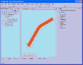
Mapyrus is software to plot Geographic Information System data, plots of points, lines, polygons and labels to PostScript (high resolution, up to A0 paper size), Portable Document Format (PDF), Scalable Vector Graphics (SVG) format and web image output fo
Category: Home & Education / Miscellaneous
Publisher: mapyrus.sourceforge.net, License: Freeware, Price: USD $0.00, File Size: 2.7 MB
Platform: Windows, Mac, Vista
World Wind is a collection of components that interactively display 3D Geographic information within Java applications or applets. Applications and applets use World Wind by placing one or more WorldWindow components in their user interface. The World Wind components are extensible. The API is defined primarily by interfaces, so components can be selectively replaced by alternative...
Category: Multimedia & Design / Graphics Viewers
Publisher: NASA, License: Freeware, Price: USD $0.00, File Size: 73.5 MB
Platform: Windows
With Bibaz you can sort your book in many categories.
With Bibaz you can sort your book in many categories. Now you can manage all your books in your library or pdf-formats so easy with the help of this software. You can categorize into many different subjects of interest like : dictionaries, cuisine books,magazines, historical books, Geographic and so on.
Category: Home & Education / Hobbies
Publisher: Jmgr, License: Freeware, Price: USD $0.00, File Size: 558.4 KB
Platform: Windows
TerraExplorer allows users to shape their own digital world.
TerraExplorer allows users to shape their own digital world.
By editing and annotating geo-referenced 3D terrain databases created through TerraBuilder, users can customize the experience to highlight specific Geographic content. By overlaying unique or proprietary information onto a 3D map, the user creates an exciting, interactive application that can highlight specific...
Category: Home & Education / Miscellaneous
Publisher: Skyline Software Systems, Inc., License: Freeware, Price: USD $0.00, File Size: 29.5 MB
Platform: Windows
PLDT Watchpad, myDSL subscribers can watch TV shows, films, and more over the internet.
PLDT Watchpad, myDSL subscribers can watch TV shows, films, and more over the internet. Available channels now include National Geographic, Cartoon Network, Pinoy Box Office, CNN, Animax Mobile, CNBC, and GMA 7, with more coming soon.
Best experienced starting with myDSL Plan 1299, Watchpad is available for free to all myDSL subscribers nationwide.
Category: Audio / Utilities & Plug-Ins
Publisher: PLDT, License: Freeware, Price: USD $0.00, File Size: 5.4 KB
Platform: Windows

Ecommerce is supposed to work 24/7 -- BUT DOES IT?
Ecommerce is supposed to work 24/7 -- BUT DOES IT? Do you really know how often your site goes down? Stop gambling and protect your online business with this free website monitoring service. We'll monitor your site constantly from multiple Geographic locations and alert you immediately by email and SMS message (text message) whenever your site goes down. It takes just a few seconds to...
Category: Business & Finance / Applications
Publisher: ezinedesigner.com, License: Freeware, Price: USD $0.00, File Size: 553.0 KB
Platform: Windows
Genealogica Grafica is the successor of KStableau.
Genealogica Grafica is the successor of KStableau. The program offers broad charting capabilities, such as: ancestor chart (pedigree) plus outline, descendants chart plus outline, ancestor tree,descendant tree, timeline descendants chart, inbreeding charts, relationship charts, circle diagrams, Geographic map of birthplaces.
This program has an a clear user interface where you can...
Category: Home & Education / Genealogy
Publisher: Tom de Neef, License: Freeware, Price: USD $0.00, File Size: 2.1 MB
Platform: Windows
50 States and Capitals is a program designed to help you to quickly learn about the location of different states of US with their capitals.
It is an easy to use program with a friendly interface designed to improve your Geographic knowlegdes.
It's a very usefull tool for those who want to know more about US.
Category: Home & Education / Miscellaneous
Publisher: Geo4Kids, License: Freeware, Price: USD $0.00, File Size: 3.6 MB
Platform: Windows
This software tool is a professional astronomy planetarium and star mapping program specially designed for Windows 9x/ME/NT/2000/XP. StarCalc illustrates the star positions at any instance of the day as observed from any Geographic location on Earth. The star positions can be viewed and presented as images in a hemispherical whole sky or in any of the user-defined sub-areas.
Category: Home & Education / Astrology & Numerology
Publisher: Alexander E. Zavalishin, License: Freeware, Price: USD $0.00, File Size: 753.4 KB
Platform: Windows
Bhuvan gives you an easy way to experience, explore and visualize IRS images.
Bhuvan gives you an easy way to experience, explore and visualize IRS images.
Bhuvan is an interactive versatile visualization system that allows users to navigate (or “fly”) the entire globe, scanning satellite imagery with overlays of natural resource information, roads, Geographic features, and numerous other location-specific data points. Users can add their...
Category: Home & Education / Miscellaneous
Publisher: AYAN TECHNOLOGIES PVT LTD, License: Freeware, Price: USD $0.00, File Size: 7.5 MB
Platform: Windows
The MapInfo License Server must be installed on your network and be accessible to all MapInfo Professional users. MapInfo Professional is a powerful Microsoft Windows-based mapping and Geographic analysis application from the experts in location intelligence. Designed to easily visualize the relationships between data and geography, MapInfo Professional helps business analysts, planners,...
Category: Home & Education / Miscellaneous
Publisher: Pitney Bowes MapInfo, License: Freeware, Price: USD $0.00, File Size: 12.1 MB
Platform: Windows
Military Overlay Editor (MOLE) is a set of COM components for developers to create custom applications that support Department of Defense . With MOLE, you can
- Add Geographic data while composing and positioning unit symbols.
- Perform automatic stacking, decluttering of symbols, and placement of leader lines.
- Import, locate, and display order of battle databases.
Category: Utilities / Misc. Utilities
Publisher: Environmental Systems Research Institute, Inc., License: Freeware, Price: USD $0.00, File Size: 116.6 MB
Platform: Windows
IP Country Lookup is a free DNS tool for Windows that lets you lookup the country an IP address or hostname originates from. It uses a locally installed file containing a list of networks and associated countries to quickly determine the Geographic source of an address. IP Country lookup is provided entirely free and is not a trial or crippled version of the application. Determing the...
Category: Internet / Tools & Utilities
Publisher: SpamButcher Spam Email Filter Software, License: Freeware, Price: USD $0.00, File Size: 1.1 MB
Platform: Windows
This is a plug-in that allows to export in atl file format from Revit 2012 running on Windows VISTA 32 or 7 32 bit to Artlantis 4. The export takes into account:
- all the 3D Views (points of views).
- the Geographic location (heliodon).
- the names of the graphics elements (materials).
- the colors of the 3D elements.
Category: Multimedia & Design / Multimedia App's
Publisher: Abvent, License: Freeware, Price: USD $0.00, File Size: 835.0 KB
Platform: Windows
ManageUPS CIO is software that provides a central management system for critical power infrastructure distributed within a building, campus or wide area network environment.Helps visualize problem locations. Map level backgrounds are any image files (JPG, GIF, PNG). Use any combination of Geographic Maps (starter set included), Floor plans, Visio drawings, even digital photos of specific...
Category: Utilities / Misc. Utilities
Publisher: Chloride Power, License: Freeware, Price: USD $0.00, File Size: 11.1 MB
Platform: Windows
Macau GeoGuide PC version, developed and maintained by the Macao Cartography and Cadastre Bureau (DSCC), is an interactive map navigation system running on desktop PC. The main functions are map navigation, feature searching and path finding. The software contains rich Geographic information and allows the users to explore and search for Macao maps without connecting to the internet.
Category: Home & Education / Miscellaneous
Publisher: DSCC, License: Freeware, Price: USD $0.00, File Size: 29.5 MB
Platform: Windows
Ecommerce is supposed to work 24/7 -- BUT DOES IT? Do you really know how often your site goes down? Stop gambling and protect your online business with this free website monitoring service. We'll monitor your site constantly from multiple Geographic locations and alert you immediately by email and SMS message (text message) whenever your site goes down. It takes just a few seconds to...
Category: Business & Finance
Publisher: ezinedesigner.com, License: Freeware, Price: USD $0.00, File Size: 550.5 KB
Platform: Windows
The Orbit Visualization Tool (OVT) is a software for visualization of satellite orbits in the Earth's magnetic field. The program can display satellite orbits in five coordinate systems (GEI, GEO, GSM, SMC, GSE), satellite footprints projected on the Earth's surface and shown in either Geographic (GEO) or geomagnetic (SMC) coordinates. In addition to satellite orbits the...
Category: Home & Education / Astrology & Numerology
Publisher: OVT Team, License: Freeware, Price: USD $0.00, File Size: 0
Platform: Windows
CensusInfo is an innovative and flexible database technology for the dissemination of population and housing census results.
Main features:
- Census indicators organised by sector
- Country-specific adaptation for indicator lists
- Census data disaggregated by socio-economic characteristics
- Sub-national data linked to census...
Category: Business & Finance / Database Management
Publisher: United Nations Statistics Division, License: Freeware, Price: USD $0.00, File Size: 167.0 MB
Platform: Windows
TOPO! Explorer is both the website you are viewing now and a free desktop application created by National Geographic Maps. The website contains freely browsable topographic maps, aerial imagery, hybrids, and a national recreation database filled with updated trails, points-of-interest, photos, videos, trail reports, and descriptions from professional and community sources. It's the...
Category: Home & Education / Miscellaneous
Publisher: National Geographic Maps, License: Freeware, Price: USD $0.00, File Size: 22.9 MB
Platform: Windows
Gismaps Viewer is a GIS viewer that can be used for geospatial analysis and map production.
Gismaps Viewer is a GIS viewer that can be used for geospatial analysis and map production.
The main features are:
- read Shape files using Geographic coordinate system
- view satellite images (MrSid, jpeg, bmp and tiff file formats)
- generate thematic maps, queries and labels
- export do Google Earth KML (shp2kml)
- configure map colors and...
Category: Multimedia & Design / Graphics Viewers
Publisher: Gismaps Sistemas Ltda., License: Freeware, Price: USD $0.00, File Size: 10.2 MB
Platform: Windows

Computer spyware virus which is also known as adware, is a program or script that secretly gathers information about you, your computer and online habits and using your internet connection relay it to advertisers and other interested parties. Some forms of computer spyware gather basic information such as operating system type, browser type, screen size, general Geographic location web...
Category: Security & Privacy / Spyware Removal
Publisher: www.free-adware-spyware-blocker.com, License: Freeware, Price: USD $0.00, File Size: 542.7 KB
Platform: Windows
FOX News Live is a stream video player for Windows.
FOX News Live is a stream video player for Windows. The application grabs video streaming feeds that are also available on FOX's website and plays those on a computer desktop. For some reason, FOX News Live did not enable me to connect to all the streams. It has just given me access to the FOX News Talk Radio, which is alright for certain news, but it would be great to actually watch the...
Category: Audio / Utilities & Plug-Ins
Publisher: Fox, License: Freeware, Price: USD $0.00, File Size: 0
Platform: Windows
Fone2Asia is a convenient application that allows you to make calls at promotional rates via PC and Mobile phones. It is free to download the client dialer itself, but you must purchase credit online in order to call.
The interface is user friendly and it straightforwardly displays all the calling options and settings, such as the equalizer buttons and the volume bar for the...
Category: Internet / Communications
Publisher: Fone2Asia, License: Freeware, Price: USD $0.00, File Size: 1.9 MB
Platform: Windows
 Freeware
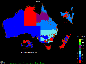
OzGIS is an extensive system for the analysis and display of geographically referenced data. About 150 menus provide an enormous range of options for: . importing data from databases, spreadsheets and Geographic Information Systems (GISs) or downloaded from Census Bureaux or mapping agencies. . processing data in preparation for display and analysis . display of data as...
Category: Home & Education / Mathematics
Publisher: OzGIS, License: Freeware, Price: USD $0.00, File Size: 313.0 KB
Platform: Windows
Christie PowerTools™ is a FREE client-based software interface that enables you to easily monitor and manage most Christie LCD, 1-chip and 3-chip DLP® projectors on your network. This single user-interface supports any number of Christie projectors on the network, regardless of their Geographic location.
Features:
- Ethernet-based control* of typical...
Category: Utilities / Misc. Utilities
Publisher: Christie Digital Systems Inc., License: Freeware, Price: USD $0.00, File Size: 83.5 MB
Platform: Windows
Standard Features:
-Look-up of US call signs
-Wild card searches on US call signs
-US zipcode database current as of Dec 2009
-Manual and automatic download of Master FCC Database
-Mini Internet Callsign Server
-Geographic coordinates computed based on zip code
-Display of Ten-Ten and VP numbers
-Lookup of Ten-Ten and VP numbers
...
Category: Business & Finance / Database Management
Publisher: Steinkamp Software Solutions, License: Freeware, Price: USD $0.00, File Size: 1.7 MB
Platform: Windows
The OSTN02 extension for ArcPad is a FREE tool that automatically transforms GPS data and aligns it with Ordnance Survey (OS) background map. This easy-to-use extension removes the need to manually post-process GPS data by providing’ on the fly’ transformation of WGS84 latitude and longitude into OSTN02 corrected British National Grid coordinate. Data capture using GPS and ArcPad is...
Category: Home & Education / Miscellaneous
Publisher: ESRI (UK) Ltd, License: Freeware, Price: USD $0.00, File Size: 8.0 MB
Platform: Windows
AZMap is a freeware Windows program which will generate, and display an Azimuthal-Equidistance map of the world, centered on any point on the surface of the earth (except very near the poles). The A-E map is also known as a Great Circle map since straight lines from the center point to any other point always fall along a great circle path and represent the shortest distance between the center...
Category: Home & Education / Miscellaneous
Publisher: Paul Burton, License: Freeware, Price: USD $0.00, File Size: 1.1 MB
Platform: Windows

The free AvisMap Viewer opens most GIS/CAD and raster image file types and most ArcView, ArcExplorer, and MapInfo projects. Besides just opening and viewing files, the Viewer supports an extensive list of features including visual layer properties control, legend control, thematic mapping, spatial and attribute querying, custom labeling, on-map measurements, hyper-linking, PDF export and much...
Category: Software Development / Components & Libraries
Publisher: AvisMap GIS Technologies, License: Freeware, Price: USD $0.00, File Size: 22.3 MB
Platform: Windows

HS GPS is a software library (with full C source code) which provides access to a NMEA-183 compliant GPS receiver via a serial communications port, decoding NMEA sentences: $GPGGA, $GPGSA, $GPGSV, $GPGLL, $GPRMC and $GPVTG. Decoded parameters include: time, date, position, altitude, speed, course and heading, according to standard - NMEA-183 (National Marine Electronics Association, Interface...
Category: Software Development
Publisher: Hillstone Software, License: Freeware, Price: USD $0.00, File Size: 309.3 KB
Platform: Windows
Freeware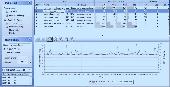
A world-class tool for network scanning, monitoring and administration: - NETWATCH: multiple host availability and response time monitoring; notifications (e-mail, message, sound) on host availability issues; current and historical charts for response times and percentage of lost packets; data export to XML, HTML, TXT; monitoring of TCP/IP services - monitoring the response time and lost...
Category: Utilities / Network
Publisher: Axence, License: Freeware, Price: USD $0.00, File Size: 35.2 MB
Platform: Windows