Free Downloads: Arcgis Explorer Free Download
ArcReader is a Free, easy-to-use desktop mapping application that allows users to view, explore, and print maps and globes. Anyone with ArcReader can view high-quality interactive maps authored by a high-level Arcgis Desktop product and published with the Arcgis Publisher extension.
ArcReader is a Free and easy-to-use application that allows users to...
Category: Desktop Enhancements / Shell & Desktop Managers
Publisher: Environmental System Research Institute, Inc., License: Freeware, Price: USD $0.00, File Size: 499.2 MB
Platform: Windows
The Geosoft Plug-in for Arcgis is an extension to the Arcgis desktop software that provides data retrieval using DAP and also support for reading Geosoft file formats. The plug-in enables users to view Geosoft grid files as a raster layer inside ArcMap. The plug-in also enables users to view Geosoft Maps as layers.
Geosoft plug-in for Arcgis includes access to Seeker,...
Category: Utilities / Misc. Utilities
Publisher: Geosoft Inc., License: Freeware, Price: USD $0.00, File Size: 133.5 MB
Platform: Windows
The Infrastructure Mobile Map template is an Arcgis Mobile application that can be used by field operations and maintenance staff in a water utility or public works department. This mobile application includes two multi-scale mobile maps (daytime and nighttime) that can be used in a disconnected network environment, two online basemaps that were authored from the Local Government Basemap...
Category: Internet / Communications
Publisher: ESRI, License: Freeware, Price: USD $0.00, File Size: 515.4 MB
Platform: Windows
GeoLabel Pro™ is a high-quality integrated text placement software for GeoMedia Professional and Arcgis.MapText has selected important capabilities of its flagship multi-GIS text placement product, Label-EZ, and created GeoLabel Pro, an easy-to- use and fully integrated software package for GeoMedia Professional and Arcgis users to display or print high-quality maps.
Category: Business & Finance / Business Finance
Publisher: MapText, License: Shareware, Price: USD $1995.00, File Size: 46.1 MB
Platform: Windows
Geosoft's Target™ for Arcgis software, built on Geosoft's industry-leading Oasis montaj™ software, simplifies the visualization and analysis of subsurface drillhole and borehole geology data within your ESRI GIS environment.
Target for Arcgis processes large volume drillhole data with ease and generates professional-quality maps for presentation,...
Category: Software Development / Misc. Programming
Publisher: Geosoft Inc., License: Shareware, Price: USD $0.00, File Size: 0
Platform: Windows
ET GeoTools is a set of tools for Arcgis which purpose is to increase the editing productivity in ArcMap, give enhanced editing functionality to the ArcView users and enable them to create and maintain topologically correct datasets.
- Identifying topology errors – draw nodes and duplicates for polyline layers, gaps and overlaps for polygon layers
-Offers usage of...
Category: Business & Finance / Business Finance
Publisher: ET SpatialTechniques, License: Shareware, Price: USD $245.00, File Size: 3.2 MB
Platform: Windows
EV8 software was created for ArcGIS 8.
EV8 software was created for Arcgis 8.x or 9.x. EV8 has : Clean and Build (Polylines to Polygons), Clean and Build: Polygons, Polylines, with intersection and dangle nodes, Automate CAD to GIS: rapidly convert CAD layers to shapefiles, Reverse Engineering: a method to control removal of gaps and slivers.
Category: Multimedia & Design / Multimedia App's
Publisher: Geokinetic Systems Inc., License: Shareware, Price: USD $98.00, File Size: 4.5 MB
Platform: Windows
SmartExporter.DXF for Arcgis/ArcMap:
- Seamless integration in Arcgis/ArcMap - adds a DXF export filter easily accessible through the ArcMap export dialog.
- Creates well-formatted DXF files, which can be opened or imported in most CAD, GIS and drawing packages.
- Complete support for all native ArcMap geo types, labels, layout elements, etc.
- Export in...
Category: Utilities / Misc. Utilities
Publisher: GIS Expert Solutions, License: Shareware, Price: USD $595.00, File Size: 874.5 KB
Platform: Windows
Isoliner is the Arcgis extension for make grids and points theme with interpolate by Kriging's and triangulation method. Last version of extension include Slide Analyst as Free function.
Isoliner include additional 3D functions, interpolation by features, generation of random points.
Category: Multimedia & Design / Multimedia App's
Publisher: GIS Planet, License: Shareware, Price: USD $0.00, File Size: 0
Platform: Windows
ET GeoTools is a set of tools for Arcgis which purpose is to increase the editing productivity in ArcMap, give enhanced editing functionality to the ArcView users and enable them to create and maintain topologically correct datasets.The tools are designed mainly for users with ArcView license, but will be asset for ArcEditor & ArcInfo license holders as well.
Category: Audio / Utilities & Plug-Ins
Publisher: ET SpatialTechniques, License: Shareware, Price: USD $245.00, File Size: 4.8 MB
Platform: Windows
SWATeditor is a companion software to ArcSWAT.
SWATeditor is a companion software to ArcSWAT. SWATeditor reads the project database generated by ArcSWAT interface to edit swat input files, execute SWAT, perform sensitivity, autocalibration and uncertainty analysis. This is a standalone program and does not require Arcgis, thus helping users of ArcSWAT to share their project with others that do not have Arcgis or much...
Category: Business & Finance / Applications
Publisher: Grassland, Soil & Water Research Laboratory, USDA-ARS, License: Freeware, Price: USD $0.00, File Size: 15.6 MB
Platform: Windows
Key Features of Geersco PDF Explorer: 1. Geersco PDF Explorer enables to index and filter PDF files metadata and toggle view of a drive's structure. 2. Geersco PDF Explorer supports to batch add and edit metadata fields, so it can save your time. 3. Geersco PDF Explorer has extensive PDF search and filtering function, such as file name, file size, file dates...
Category: Multimedia & Design / PDF Tools
Publisher: Geersco.com, License: Freeware, Price: USD $0.00, File Size: 1.9 GB
Platform: Windows
WellTracking is an Arcgis based solution for effective management and visualization of 3D spatial well drilling data on a corporate level.
The program automates all spatial data management processes related to the life-cycle of the well allowing monitoring and controlling all stages of the drilling process.
Category: Utilities / Misc. Utilities
Publisher: DataEast, LLC, License: Shareware, Price: USD $3905.06, File Size: 55.4 MB
Platform: Windows

Free toolbar for Internet Explorer and Firefox for searching free programs to download. .
Free toolbar for Internet Explorer and Firefox for searching free programs to download.
Category: Internet
Publisher: Software Headlines, License: Freeware, Price: USD $0.00, File Size: 146.5 KB
Platform: Windows
The first product from WebBridge series for operation with Internet tiles maps in the environment of Arcgis. The program allows to connect directly in project ArcMap the raster layer linked to one of Internet services, to display depending on scale appropriate level of an Internet map. The program does not demand usage Arcgis Server/ImageServer or access to Virtual Earth through...
Category: Internet / Misc. Plugins
Publisher: MitrichTools, License: Demo, Price: USD $0.00, File Size: 581.5 KB
Platform: Windows
Internet Explorer BufferZone Security allows you to browse anywhere and Download anything with complete safety. BufferZone's revolutionary virtualization technology creates an isolated zone on your PC, which separates your operating system and confidential data from unknown files and programs. Unlike anti-virus and anti-spyware software, Internet Explorer BufferZone...
Category: Internet / Browsers
Publisher: Trustware, License: Freeware, Price: USD $0.00, File Size: 675.8 KB
Platform: Windows
Free Internet Explorer Toolbar-Download-Full featured Internet Explorer toolbar brought to you with compliments-www.hemorrhoidz.com-hemorrhoid remedy
The toolbar features Temperature Links, Radio Station with different song Themes and News Ticker Tape.
If you require expert help on Haemorrhoid Problems please feel Free to...
Category: Internet / Browsers
Publisher: hemorrhoid remedy, License: Freeware, Price: USD $0.00, File Size: 1.5 MB
Platform: Windows
ET Surface is a set of tools for Arcgis that enable the users to create surfaces and perform surface analysis without the need of 3D or Spatial Analyst extensions. The only requirement is an Arcgis license (ArcView, ArcEditor or ArcInfo).
ET Surface 2.0 introduces ET TerrainViewer which allows 3D visualization of surfaces (PolygonZ TINs and Rasters) as well as features...
Category: Multimedia & Design / Image Editing
Publisher: ET Spatial Techniques, License: Shareware, Price: USD $295.00, File Size: 11.0 MB
Platform: Windows
The ArcPhoto Tools are a set of geoprocessing tools and ArcMap user interface enhancements to enable the quick import of digital photography into the Arcgis framework. The tools work directly off the EXIF (Exchangeable image file format) header information that is encoded into digital imagery. This information usually includes information about the type of camera used, focal length,...
Category: Multimedia & Design / Multimedia App's
Publisher: ESRI, License: Freeware, Price: USD $0.00, File Size: 25.0 MB
Platform: Windows
Internet Explorer BufferZone Security allows you to browse anywhere and Download anything with complete safety. BufferZone's revolutionary virtualization technology creates an isolated zone on your PC, which separates your operating system and confidential data from unknown files and programs. Unlike anti-virus and anti-spyware software, Internet Explorer BufferZone...
Category: Internet
Publisher: Trustware, License: Freeware, Price: USD $0.00, File Size: 677.7 KB
Platform: Windows
Browser SX is an Internet Explorer based tabbed browser.
Browser SX is an Internet Explorer based tabbed browser.At this moment Free beta version is available for Download.Use it as Internet Explorer replacement or if you trouble any difficulties running standard Internet Explorer (MSIE) More details athttp://www.rf1.net/
Category: Internet / Browsers
Publisher: RF1 Systems, License: Freeware, Price: USD $0.00, File Size: 665.6 KB
Platform: Windows
DataEast CarryMap is an extension to Arcgis Desktop that lets you create distributable portable maps in a short time and with minimal effort.
Map application created with Carry Map can be run on any Windows computer or Windows Mobile device by any user – no need for additional software or professional GIS skills. You can send it, add it to a presentation, burn to a CD...
Category: Home & Education / Miscellaneous
Publisher: DataEast, LLC., License: Shareware, Price: USD $162.10, File Size: 11.3 MB
Platform: Windows
Shape Viewer is a free tool, which you can use to view ESRI Shape files.
Shape Viewer is a Free tool, which you can use to view ESRI Shape files.
Shape Viewer can open (.shp) files that contain the geometry information of the shape file.With Shape Viewer you can also create new (.shx) file, and new empty (.dbf) file for your shape file.
If you have hundreds of shape files, and you want to view their contents rapidly, and you don't want to...
Category: Multimedia & Design / Graphics Viewers
Publisher: Mohammed Hammoud, License: Freeware, Price: USD $0.00, File Size: 35.0 KB
Platform: Windows
PDF Download for Internet Explorer is a useful tool for downloading any web page content.
PDF Download for Internet Explorer is a useful tool for downloading any web page content.
It allows you to copy and convert the content of an entire webpage into a PDF document. You are, then, able to send the downloaded document to your e-mail account so that you can save and use it almost instantly. An appreciable feature of this application is the fact that it can...
Category: Internet / Download Managers
Publisher: Nitro PDF Software, License: Freeware, Price: USD $0.00, File Size: 421.0 KB
Platform: Windows
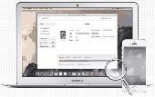
Macgo Free iPhone Explorer for Mac is a Free iOS file explore software, it is designed to access, explore and manage your iOS file system. With the freeware, you can easily add and delete all types of file saved on your iOS devices. Moreover, it allows you to copy all types of files between your Mac and iOS devices, it is also an easy and safe software to operate with....
Category: Utilities / System Utilities
Publisher: Macgo International Ltd., License: Freeware, Price: USD $0.00, File Size: 35.2 MB
Platform: Mac,