Free Downloads: Arcview Demo
The ARC3WMS client is an ArcView 3 extension (.
The ARC3WMS client is an Arcview 3 extension (.AVX) that provides access to data sets stored on a Web Map Server (WMS). WMS is an internet mapping protocol published by the OpenGIS Consortium. WMS servers publish map images to remote clients using standard internet technologies. There are WMS servers for LandSat data, USGS DOQ photos, bathymetry, and many other data types.
Category: Multimedia & Design / Multimedia App's
Publisher: Refractions Research Inc, License: Freeware, Price: USD $0.00, File Size: 2.1 MB
Platform: Windows
ET GeoTools is a set of tools for ArcGIS which purpose is to increase the editing productivity in ArcMap, give enhanced editing functionality to the Arcview users and enable them to create and maintain topologically correct datasets.The tools are designed mainly for users with Arcview license, but will be asset for ArcEditor & ArcInfo license holders as well.
Category: Audio / Utilities & Plug-Ins
Publisher: ET SpatialTechniques, License: Shareware, Price: USD $245.00, File Size: 4.8 MB
Platform: Windows
ET GeoWizards is a set of powerful functions that will help the ArcGIS users to manipulate data with ease. It enables the ArcGIS users with Arcview licenses to perform some data processing tasks standardly possible only in ArcEditor and ArcInfo. The surface functions make possible to do 3D analysis in ArcMap with no need of 3D Analyst.
The main target of the software are the...
Category: Business & Finance / Business Finance
Publisher: ET SpatialTechniques, License: Shareware, Price: USD $0.00, File Size: 6.6 MB
Platform: Windows
ET GeoWizards is a set of powerful functions that will help the ArcGIS users to manipulate data with ease. It enables the ArcGIS users with Arcview licenses to perform some data processing tasks standardly possible only in ArcEditor and ArcInfo. The surface functions make possible to do 3D analysis in ArcMap with no need of 3D Analyst.
The main target of the software are the...
Category: Software Development / Misc. Programming
Publisher: ET SpatialTechniques, License: Shareware, Price: USD $245.00, File Size: 7.1 MB
Platform: Windows
Point Analyst is an extension to the Arcview® GIS designed for the exploratory analysis of spatial sampling and analysis methods.
New users should read the concepts section to understand the motivation and principles behind the stratified interpolation function provided in the extension.
-Stratified interpolation: Point interpolation using ordinary point...
Category: Software Development / Misc. Programming
Publisher: Dr. Rob Rempel, License: Demo, Price: USD $0.00, File Size: 739.8 KB
Platform: Windows
DNRGarmin is a smart tool used to directly transfer data between Garmin GPS handheld receivers and various GIS software packages.
DNRGarmin was built to provide users the ability to directly transfer data between Garmin GPS handheld receivers and various GIS software packages. Using DNRGarmin a user can use point features (graphics or shapefile) and upload them to the GPS as...
Category: Utilities / Misc. Utilities
Publisher: GIS Section, Minnesota Department of Natural Resources, License: Freeware, Price: USD $0.00, File Size: 11.3 MB
Platform: Windows
Using Arcview, you can understand the geographic context of your data, allowing you to see relationships and identify patterns in new ways.
Main features:
- Author maps and interact with your data by generating reports and charts and printing and embedding your maps in other documents and applications.
- Save time using map templates to create consistent...
Category: Home & Education / Teaching Tools
Publisher: Environmental Systems Research Institute, Inc., License: Shareware, Price: USD $1.50, File Size: 0
Platform: Windows
ET GeoTools is a set of tools for ArcGIS which purpose is to increase the editing productivity in ArcMap, give enhanced editing functionality to the Arcview users and enable them to create and maintain topologically correct datasets.
- Identifying topology errors – draw nodes and duplicates for polyline layers, gaps and overlaps for polygon layers
-Offers usage of...
Category: Business & Finance / Business Finance
Publisher: ET SpatialTechniques, License: Shareware, Price: USD $245.00, File Size: 3.2 MB
Platform: Windows
Seismovision is a very versatile Demo player which makes it very easy to play back demos on your computer.
What is a Demo? A Demo is a recording of game of someone playing. Simply double-click on a Demo to play it, whether it is from a compressed archive, over a network or right of your desktop.
Even create Demo play lists with the...
Category: Multimedia & Design / Video
Publisher: NuGardt Software, License: Shareware, Price: USD $0.00, File Size: 0
Platform: Windows
Want to try EZ LADDER for yourself?
Want to try EZ LADDER for yourself? Try the EZ LADDER Toolkit Demo. The downloadable Demo allows you the opportunity to try the user interface, place objects and function blocks and draw ladder diagram rungs. You can create your own ladder diagram using this Demo.The EZ LADDER Toolkit Demo's functionality is limited to allowing program creation. Program...
Category: Multimedia & Design / Multimedia App's
Publisher: Divelbiss Corporation, License: Demo, Price: USD $0.00, File Size: 78.7 MB
Platform: Windows
ET GeoWizards is a set of powerful functions that will help the ArcGIS users to manipulate data with ease. It enables the ArcGIS users with Arcview licenses to perform some data processing tasks standardly possible only in ArcEditor and ArcInfo. The surface functions make possible to do 3D analysis in ArcMap with no need of 3D Analyst.
Category: Multimedia & Design / Multimedia App's
Publisher: Environmental Systems Research Institute, Inc, License: Shareware, Price: USD $60.00, File Size: 5.9 MB
Platform: Windows
Oasis montaj Viewer is a easy-to-use program that allows anyone to view, share, and print published Geosoft grid (.grd) and database (.gdb) files. The viewer can also be used to convert grids and images to a variety of supported data formats, including AutoCAD, Arcview, ER Mapper, TIF, and many more.
Category: Multimedia & Design / Graphics Viewers
Publisher: GEOSoft, License: Freeware, Price: USD $0.00, File Size: 137.4 MB
Platform: Windows
You know X-Tools? Grid Machine is X-Tools for grid themes. In ArcViews Spatial Analyst the options to work with grids are very limited, especially if you have requests for multiple grids. Even simple actions (like copy, rename, import, export) are only provided for single grids. Gridmachine offers a lot of helpful tools for the work with Arcview/Spatial Analyst, like the above...
Category: Business & Finance / Database Management
Publisher: ECOGIS Geomatics, License: Shareware, Price: USD $199.00, File Size: 736.2 KB
Platform: Windows
The Demo version of RelMo is virtually identical to the current full version on RelMo Design, but with one restriction, in the Demo version you cannot print.
A few sample files are included in the installation package to get you starte.
Also included with the Demo version is the download utility which allows you to communicate directly with a number of different...
Category: Multimedia & Design / Multimedia App's
Publisher: AiTS Software, License: Freeware, Price: USD $0.00, File Size: 7.9 MB
Platform: Windows
JFreeChart Demo is a Demo of another product, JFreeChart, that is a free Java chart library for program developers. By using JFreeChart, the Java developers will be able to include professional quality charts in the applications they build. JFreeChart Demo just demonstrates the charts that are included in that .class file. You will be able to download it and see the...
Category: Software Development / Misc. Programming
Publisher: Object Refinery, License: Demo, Price: USD $65.00, File Size: 847 B
Platform: Windows
Superoverlay software is a Google Earth application for tiling raster datasets and creating view based regions in KML or KMZ files.
Also Superoverlay can generate world files for all images in Arcview style (jgw, tfw,...). It helps you put large image overlays into Google Earth (for example alternative maps or aerial photography). GE Sky mode is supported.
Category: Home & Education / Miscellaneous
Publisher: GIS Center, License: Shareware, Price: USD $0.00, File Size: 0
Platform: Windows
Download FluidRay for SketchUp demo.
Download FluidRay for SketchUp Demo. The Demo version has all the features of the full version except for a limited resolution. Simply extract it and run setup. It must be installed in SketchUp’s plugins directory. By default, the installer will set the install directory to SketchUp 8. If you are using SketchUp 7, please change it to SketchUp 7.
Category: Multimedia & Design / Multimedia App's
Publisher: Fluid Interactive, License: Demo, Price: USD $0.00, File Size: 27.7 MB
Platform: Windows
GenesisIV understands GIS concepts like layers, shape objects and georeferencing.
GenesisIV understands GIS concepts like layers, shape objects and georeferencing. It interfaces to industry standard GIS systems such as MapInfo and Arcview so you can use your existing data without having to learn new concepts or perform difficult manipulations.
GenesisIV is the only landscape product designed specifically to help teach geographical concepts. You're up...
Category: Multimedia & Design / Multimedia App's
Publisher: Geomantics, License: Freeware, Price: USD $0.00, File Size: 17.6 MB
Platform: Windows
Have you ever wondered why EA Sports disabled most of GamePads to be used in FIFA 12 PC Demo?
Have you ever wondered why EA Sports disabled most of GamePads to be used in FIFA 12 PC Demo? If so, you’re not the same. As the Demo got released , we’ve seen many unhappy user stating on forums that they can’t play FIFA 12 Demo because the game crashes/is not recognizing their GamePad!
So there you go. We have solution, and that is GamePad Fix for...
Category: Games / Misc. Games
Publisher: Hrvoje BAJLO, License: Freeware, Price: USD $0.00, File Size: 1.7 MB
Platform: Windows
Learn MS. Excel 2000 With Very Easy Step. This Demo Learn MS Excel 2000 help of animated Demo. In This Demo plackbck Time Approximate 2880 seconds or 48 min. This Is Only Demo. Purchase The Full Version And Learn All Commands. This is self learning MS Excel help every beginner in gaining expertise in MS Excel working and an advanced professional to get further...
Category: Home & Education
Publisher: Cyber Tech, License: Shareware, Price: USD $20.00, File Size: 12.6 MB
Platform: Windows, 97
Demo Expander 12 is the only utility on the scene that allows you to play in snow or rain weather with your FIFA 12 PC Demo! This particular setting has been hidden by EA Sports, and by the default, You’re unable to see how the game looks on these modes! But that’s over, You don’t have to wait for the final version of the game!
ou can also play on different...
Category: Games / Sports
Publisher: FIFA Web Portal.net, License: Freeware, Price: USD $0.00, File Size: 288.4 KB
Platform: Windows
CSI - Hard Evidence DEMO, is the demo of the fourth and last pc videogame of the CSI saga.
CSI - Hard Evidence Demo, is the Demo of the fourth and last pc videogame of the CSI saga. Compatible with Windows 2000 / XP / Vista. The minimum system requirements for play this videogame are: 2.0 GHz processor or better, 512MB RAM, 64MB 3D-accelerated video card and 1.5GB hard drive space.
In this Demo, you have to search for new evidence in the crime scene. Once...
Category: Games / Simulations
Publisher: Telltale Games, License: Demo, Price: USD $0.00, File Size: 0
Platform: Windows
Learn MS. Word 2000 With Very Easy Step. This Demo Learn MS Word 2000 help of animated Demo. In This Demo plackbck Time Approximate 1803 seconds or 30.05 min.. This Is Only Demo. Purchase The Full Version And Learn All Commands. This is self learning MS Word 2000 help every beginner in gaining expertise in MS Word working and an advanced professional to get further...
Category: Home & Education
Publisher: Cyber Tech, License: Shareware, Price: USD $20.00, File Size: 8.8 MB
Platform: Windows, 97
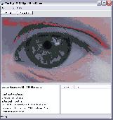
Eye iris identification algorithm demo application for MS Windows.
Eye iris identification algorithm Demo application for MS Windows. The robust proprietary iris recognition technology accepts images with gazing away eyes or narrowed eyelids and provides reliable iris matching at speeds up to 150,000 irises per second. The Demo application reads iris images from image files and does not require internet connection.
Category: Software Development / Components & Libraries
Publisher: Neurotechnology, License: Demo, Price: USD $1239.00, File Size: 1.3 MB
Platform: Windows

The free AvisMap Viewer opens most GIS/CAD and raster image file types and most Arcview, ArcExplorer, and MapInfo projects. Besides just opening and viewing files, the Viewer supports an extensive list of features including visual layer properties control, legend control, thematic mapping, spatial and attribute querying, custom labeling, on-map measurements, hyper-linking, PDF export...
Category: Software Development / Components & Libraries
Publisher: AvisMap GIS Technologies, License: Freeware, Price: USD $0.00, File Size: 22.3 MB
Platform: Windows