Free Downloads: Atlas Maps Gps
HistorAtlas: free historical atlas.
HistorAtlas: free historical Atlas. World history
HistorAtlas is a free software that you can download and install on your computer. It has 168 historical Maps with their description and a timeline that helps you on navigation. You find also an illustrated chronology and animated Maps.
Category: Home & Education / Miscellaneous
Publisher: romano.mazzini, License: Freeware, Price: USD $0.00, File Size: 4.9 MB
Platform: Windows
Create Gps enabled geo Maps directly on the background of aereal photos and road Maps from the internet. Import geodata from Google-Earth, OpenStreetMap, Gps tracks and Gps logger. Map editor , manually digitizing. Specifical graphical objects (borderlines, borderareas) to guarantee exact same borders of neighbour areas..Screen calibration for true to display...
Category: Multimedia & Design / Digital Media Editors
Publisher: GPSur Dr. Erhard Regener, License: Shareware, Price: USD $65.00, File Size: 6.4 MB
Platform: Windows
 Shareware
Gps Mapping Software for Windows, Loading topographic Maps, realtime navigation, track recording, manage Gps devices and more. The software can be used with various map formats including: GeoTiff, BSB Nautical Charts, AutoCad DXF files, ESRI Shapefiles. Using calibration you can also use scanned or downloaded JPG, BMP, GIF, PNG and TIF Maps. The software can be used...
Category: Home & Education / Science
Publisher: Eye4Software B.V., License: Shareware, Price: USD $149.00, EUR99, File Size: 11.1 MB
Platform: Windows
APRS SA does most of the functions of the original APRS(tm) with a big difference: The Maps it uses to plot the locations are Street Atlas 4.0 or 5.0 Maps. This allows great precision in locating objects and stations. This program track a moving vehicle and do it at the street level.
Category: Home & Education / Miscellaneous
Publisher: Brent Hildebrand, KH2Z, License: Freeware, Price: USD $0.00, File Size: 2.0 MB
Platform: Windows
Atlas DMT is a graphic interactive system for 3D surface modeling and visualization, featuring a special focus on terrain modeling.
Atlas DMT can process elevation data (points, breaklines) from various sources - e.g., total stations, photogrammetry, digitized Maps, proprietary formats (Kokes, Topol, Hydroinform) or text files (imported or prepared manually).
Category: Multimedia & Design / Image Editing
Publisher: Atlas, spol. s r. o., License: Shareware, Price: USD $0.00, File Size: 0
Platform: Windows
Electronic World atlas for Radio Amateurs.
Electronic World Atlas for Radio Amateurs. Scrollable World map with smooth zoom, DXCC territories, province/state prefixes, Grid Squares, CQ and ITU Zones in the rectangular, azimuthal and Globe projections, 3D relief, Gray Line, city and island index, unique hierarchical prefix database, local time with DST for all cities, islands and call areas, unique ionospheric Maps.
Category: Home & Education / Miscellaneous
Publisher: Afreet Software, Inc., License: Freeware, Price: USD $0.00, File Size: 7.6 MB
Platform: Windows
Covering every month of every theatre of World War II, this huge Atlas is for wargamers and anyone interested in World War II. It provides a highly interactive and thought-provoking view of the war, and is a great starting point for what-if scenarios. Each map contains date, movement, unit strengths and other military details.
From the world overview you can cycle through...
Category: Home & Education / Miscellaneous
Publisher: ProFantasy Software, License: Shareware, Price: USD $27.95, File Size: 57.0 MB
Platform: Windows
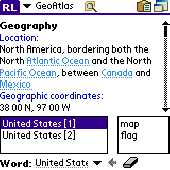
Learn more about countries in the World. Keep this Atlas as the reference when you need geographical information such as country location, neighbours, capital, population, economy, military and more including country map and flag pictures. Whenever you solve a crossword puzzle, perform study research, watch TV news or just get interested in geography - this Atlas helps you with...
Category: Home & Education
Publisher: AbsoluteWord, License: Shareware, Price: USD $19.95, File Size: 4.4 MB
Platform: Palm
Shareware
Gps Mapping Software for Windows, Loading topographic Maps, manage Gps devices and more. The software can be used with various map formats including: GeoTiff, BSB Nautical Charts, AutoCad DXF files, ESRI Shapefiles. Using calibration you can also use scanned or downloaded JPG, BMP, GIF, PNG and TIF Maps. The software can be used for survey, research, track and trace,...
Category: Home & Education / Science
Publisher: Eye4Software B.V., License: Shareware, Price: USD $75.04, EUR49, File Size: 6.7 MB
Platform: Windows
GPS Send Map is a Windows interface program which uses (sendmap.
Gps Send Map is a Windows interface program which uses (sendmap.exe) to load the IMG Maps to the Gps.This program works well and setup is easy, although there seams to be minor issues in some windows OS.The Gps acted as usual and my Maps appeared on the screen as usual. NICE.
Category: Security & Privacy / Other
Publisher: DougsBrat, License: Freeware, Price: USD $0.00, File Size: 1.5 MB
Platform: Windows
With MetroWizzz- the Autorouting MetroGuide Wizard, you can make your Gps capable of autorouting with MetroGuide Maps. The wizard is self explaining. In just 6 simple steps you will have autorouting capabilities with MetroGuide Maps on your Gps. You can upload up to 1Gb of Maps to your Gps.
Category: Home & Education / Miscellaneous
Publisher: Geodude, License: Freeware, Price: USD $0.00, File Size: 962.2 KB
Platform: Windows
The Gps Detector software is used to update the Gps detector's database , updating Maps , routes and camera locations . The device itself is based on pre-installed Gps coordinates, the device can indicate various road hazards like: Fixed cameras, Red light speed cameras and bus lane cameras, Usual speed measurement places and dangerous zones.
Category: Business & Finance / Business Finance
Publisher: Euro Noliker Kft., License: Freeware, Price: USD $0.00, File Size: 5.5 MB
Platform: Windows
Moagu: The Mother Of All GPS Utilities.
Moagu: The Mother Of All Gps Utilities.
You can convert USGS topographic Maps, aerial/satellite imagery, and any other raster map imagery for use on Garmin handled Gps units.
Garmin Maps have been in a "vector" format; Moagu creates Maps using a "bitmap" format.
Category: Home & Education / Miscellaneous
Publisher: Moagu, License: Shareware, Price: USD $19.95, File Size: 38.2 MB
Platform: Windows
FREE GPS Software for your Garmin, Magellan or Lowrance GPS.
FREE Gps Software for your Garmin, Magellan or Lowrance Gps.
EasyGPS is the fast and easy way to upload and download waypoints, routes, and tracks between your Windows computer and your Garmin, Magellan, or Lowrance Gps. EasyGPS lists all of your waypoints on the left side of the screen, and shows a plot of your Gps data on the right. Use EasyGPS to back up...
Category: Internet / Communications
Publisher: TopoGrafix, License: Freeware, Price: USD $0.00, File Size: 3.9 MB
Platform: Windows
OZtopo provides an alternative set of maps, suitable for use on Garmin GPS units.
OZtopo provides an alternative set of Maps, suitable for use on Garmin Gps units. It has been designed as a detailed set of topographical Maps suitable for bushwalking, 4WDing and general touring . It is comprised of two mapsets, 10m Contours and Roads and Tracks. Both mapsets can be loaded onto a Gps at the same time. They can also be loaded concurrently with any of...
Category: Business & Finance / Business Finance
Publisher: Oztopo, License: Shareware, Price: USD $0.00, File Size: 75.7 MB
Platform: Windows
CompeGPS is an essential software to make the most of your Gps. With this PC software you will be able to download a wide variety of cartography from the internet and also analyse your routes. This software has been specially designed for free flight and motor flight pilots they use Gps and likes to create and accomplish their own routes and then later on analyse. CompeGPS...
Category: Home & Education
Publisher: CompeGPS TEAM S.L., License: Shareware, Price: USD $106.00, File Size: 14.9 MB
Platform: Windows
TOPO! Explorer is both the website you are viewing now and a free desktop application created by National Geographic Maps. The website contains freely browsable topographic Maps, aerial imagery, hybrids, and a national recreation database filled with updated trails, points-of-interest, photos, videos, trail reports, and descriptions from professional and community sources....
Category: Home & Education / Miscellaneous
Publisher: National Geographic Maps, License: Freeware, Price: USD $0.00, File Size: 22.9 MB
Platform: Windows
CompeGPS is an essential software to make the most of your Gps. With this PC software you will be able to download a wide variety of cartography from the internet and also analyse your routes. This software has been specially designed for 4x4 lovers, bike tourists, excursionists and, in general, everyone who uses Gps, likes to create and accomplish their own routes and then...
Category: Home & Education
Publisher: CompeGPS TEAM S.L., License: Shareware, Price: USD $106.00, File Size: 14.9 MB
Platform: Windows
Atlas is a high quality machine translation software package for Japanese to English and English to Japanese. Atlas has a sophisticated content-sensitive translation engine and comprehensive standard dictionary that contains 2,880,000 words. Moreover with Atlas Technical Dictionaries, you can add an additional 5.57 million words.
Atlas offers plugins that...
Category: Home & Education / E-books & Literature
Publisher: FUJITSU LIMITED, License: Shareware, Price: USD $0.00, File Size: 0
Platform: Windows
Eye4Software Gps Mapping is a professional Gps mapping software tool that can be used in numerous applications. Use the software to load, view and edit your Maps, display your position realtime and record all your movements.
The software will work with almost any Gps and can be used on any desktop, laptop or needbook computer running Windows XP or...
Category: Home & Education / Miscellaneous
Publisher: Eye4Software B.V., License: Shareware, Price: USD $130.61, File Size: 14.6 MB
Platform: Windows
Euratlas Periodis Expert is a database and a historical atlas of Europe with editing functions.
Euratlas Periodis Expert is a database and a historical Atlas of Europe with editing functions. It describes the political status of Europe, North Africa and Near East at fixed intervals, from year 1 until year 2000.
Stress is put on the precise drawing of territories at one exact instant defined by fixed length intervals, that is the first day of each centennial year.
...
Category: Home & Education / Miscellaneous
Publisher: Euratlas, License: Shareware, Price: USD $77.80, File Size: 33.2 MB
Platform: Windows
Map of Africa is one of the many maps created for GPS TrackMaker.
Map of Africa is one of the many Maps created for Gps TrackMaker. You are able to download the installation package from the TrackMaker website. In order to preview the contents of this package, you need to install Gps TrackMaker.
Using the above mentioned application, you will be able to see the Map of Africa. Just click on the "Open Temporary...
Category: Home & Education / Miscellaneous
Publisher: Geo Studio Technology, License: Freeware, Price: USD $0.00, File Size: 18.3 MB
Platform: Windows
Freeware
GPS Converter will convert GPS coordinates between three different formats: 34. 26965, -116.
76783; N 34° 16. 179', W 116° 46. 07'; and N 34° 16' 10.
Category: Home & Education / Sports
Publisher: ALMSys, Inc., License: Freeware, Price: USD $0.00, File Size: 929.9 KB
Platform: Windows
With links and additional information on important topics for geography lessons.
With links and additional information on important topics for geography lessons. 3D-view of Atlas (book) Maps on a virtual globe, high resolution physical map, political map, satellite images, land coverage and earth-at-night map. Create your own map legend, use the drawing tool, move and insert Atlas symbols and much more.
Category: Multimedia & Design / Fonts
Publisher: Imagon GmbH, License: Freeware, Price: USD $0.00, File Size: 6.1 MB
Platform: Windows
TopoFusion is a GPS Mapping program for Windows.
TopoFusion is a Gps Mapping program for Windows. It downloads Maps (Topo, Aerial Photo and Satellite) automatically from several public map servers.
It seamlessly displays imagery from Terraserver and the OnEarth Server. Maps are downloaded on demand (as the user pans or zooms around the map) and cached on the user's hard drive for faster (and offline) storage.
Category: Utilities / Misc. Utilities
Publisher: TopoFusion, License: Shareware, Price: USD $69.95, File Size: 7.4 MB
Platform: Windows