Free Downloads: Earth View Maps Software
WALL32 is a self-contained, real-time wallpaper generator, which simulates the Earth?
WALL32 is a self-contained, real-time wallpaper generator, which simulates the Earth?s and Moon?s illumination by the sun. The Earth View includes twilight zones and the Moon View takes the earthshine (Da Vinci?s Glow) into account.
Category: Desktop Enhancements / Wallpaper
Publisher: vakitmatik.tripod.com, License: Freeware, Price: USD $0.00, File Size: 137.3 KB
Platform: Windows, Mac, Vista
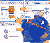
Now you can link the individuals in your family tree to the powerful mapping capabilities of Google Earth. Automatically create Placemarks for events in the lives of individuals and View a path following the movements during their lifetime. Use the timespan slider feature of Google Earth to restrict the View to a period of history and watch your family's story...
Category: Home & Education / Miscellaneous
Publisher: Integrated Earth, License: Shareware, Price: USD $20.00, File Size: 3.2 MB
Platform: Windows
Shape2Earth leverages freely available and easy to use Geographic Information System (GIS) Software to create professional visualizations for viewing in GoogleTM Earth.
Main features:
-Convert Any Shapefile to KML - Shape2Earth reprojects your data on the fly
-Apply Thematic Symbology to your Data - Color code to display information
-Present Data in...
Category: Multimedia & Design / Image Editing
Publisher: Google, License: Demo, Price: USD $0.00, File Size: 9.5 MB
Platform: Windows
Seismic Waves is a Windows program which illustrates how wave propagate from an earthquake hypocenter to seismic stations throughout the Earth. One sees waves propagating out from the epicenter on a three-dimensional View of the Earth at the same time one sees waves propagating through a cross-sectional View of the Earth. These two wave propagation views are...
Category: Home & Education / Science
Publisher: Alan L. Jones, License: Freeware, Price: USD $0.00, File Size: 2.6 MB
Platform: Windows
Beautiful Earth is a Wallpaper generator and Screen Saver.
Beautiful Earth is a Wallpaper generator and Screen Saver. Beautiful Earth shows you how the Earth looks like from the space at this very moment. You can see which parts of the Earth are enjoying the sun light. And in night areas you can see the city lights. Based on NASA's Blue Marble and City Lights satellite images.
Category: Desktop Enhancements / Screensavers
Publisher: GimmeGoody.com, License: Shareware, Price: USD $24.99, File Size: 2.7 MB
Platform: Windows
PlanetGIS Explorer is a free viewer for PlanetGIS maps and GIS exchange files.
PlanetGIS Explorer is a free viewer for PlanetGIS Maps and GIS exchange files. PlanetGIS Explorer allows you to navigate through Maps, query map elements and View attribute information from linked database tables. Also PlanetGIS Explorer allows you to customize the appearance of Maps for purposes of creating hardcopy printouts, but does not allow you to save any...
Category: Multimedia & Design / Graphics Viewers
Publisher: Planet GIS, License: Freeware, Price: USD $0.00, File Size: 5.4 MB
Platform: Windows
GPicSync automatically inserts location in your photos metadata so they can also be used with any 'geocode aware' application like Picasa/Google Earth, Flickr, loc.alize.us.
Main fetures:
- automatically geocode your photos (in the EXIF header)
- use a GPS tracklog in the GPX format or NMEA format (multiple selection possible)
- Support elevation...
Category: Multimedia & Design / Digital Media Editors
Publisher: Google Project, License: Freeware, Price: USD $0.00, File Size: 0
Platform: Windows
Manifold Toolbar is a powerful and handy application that allows you to View a map or satellite image of any place on Earth directly on your browser without the need of any other program. You just have to type a location (city and country, city and state) in the search bar and it automatically displays satellite images or street Maps, allowing you zoom in and out to see...
Category: Internet / Browser Accessories
Publisher: CDA International, License: Freeware, Price: USD $0.00, File Size: 1.5 MB
Platform: Windows
See our Earth?s beauty in high-resolution! Fully customizable by you - you can change the size of the images as well as the transitions of the slide show. Download this screensaver and enjoy it today!
Category: Desktop Enhancements / Screensavers
Publisher: leetsoftware.com, License: Freeware, Price: USD $0.00, File Size: 3.5 MB
Platform: Windows, Mac, 2K, 2K3
MAPC2MAPC is a program to manipulate digital Maps,it loads map images and calibrate them,loads calibrations in many different formats and Datums,View the calibrated map,crop and rescale Maps whilst preserving the calibration,reproject Maps to 'Plate Carre' (Equirectangular),rotate Maps to true North.
Category: Multimedia & Design / Digital Media Editors
Publisher: Thorn, License: Shareware, Price: USD $0.00, File Size: 1.6 MB
Platform: Windows

OkCustomMap is a software to produce Garmin Custom Maps.
OkCustomMap is a Software to produce Garmin Custom Maps.
Supports many map formats:
- OkMap
- Ecw
- GeoTiff
- World files
- OziExplorer
- GpsTuner
You can customize:
- The quality of the output JPEG images (0=Bad, 100=Good)
- The KML transparency (0=Transparent, 255=Opaque)
- The KML draw order (0=Invisible, 1-49=Under the vectorial...
Category: Business & Finance / Applications
Publisher: Gian Paolo Saliola, License: Freeware, Price: USD $0.00, File Size: 3.2 MB
Platform: Windows
 Shareware
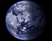
EarthView is a dynamic desktop wallpaper and screen saver, which displays beautiful views of the Earth with daylight and night shadows. It produces colorful, high quality, high resolution images for every screen resolution - even beyond 3840x2160! The program supports map and globe views, urban areas, city lights, atmospheric effects, clouds, weather information, local time display and...
Category: Software Development
Publisher: DeskSoft, License: Shareware, Price: USD $25.00, File Size: 18.3 MB
Platform: Windows
ArcReader is a free, easy-to-use desktop mapping application that allows users to View, explore, and print Maps and globes. Anyone with ArcReader can View high-quality interactive Maps authored by a high-level ArcGIS Desktop product and published with the ArcGIS Publisher extension.
ArcReader is a free and easy-to-use application that allows users to...
Category: Desktop Enhancements / Shell & Desktop Managers
Publisher: Environmental System Research Institute, Inc., License: Freeware, Price: USD $0.00, File Size: 499.2 MB
Platform: Windows
Freeware
Arm Map Explorer recreates all the functionalities of Google Maps on your desktop while expanding them with new extras. Map Explorer lets you locate and View any place on the planet using dynamic interactive Maps. These Maps are draggable, which means there is no need for you to click and wait for graphics to reload each time you want to View adjacent parts of...
Category: Internet / Flash Tools
Publisher: ArmCode, License: Freeware, Price: USD $0.00, File Size: 5.5 MB
Platform: Windows
Satellite earth is a software for viewing satellite and aerial imagery of the Earth.
Satellite Earth is a Software for viewing satellite and aerial imagery of the Earth.Satellite Earth allows you to enjoy virtual travel around the world, look up local information and plan trips, exploring multimedia content and share information about your trips.Explore towns, cities and terrain relief shown in three-dimensional images of high resolution associated...
Category: Home & Education / Science
Publisher: www.satelliteview-of-my-house.com, License: Freeware, Price: USD $0.00, File Size: 584.0 KB
Platform: Windows
MapComp is a powerful and free Windows Software for drawing images of linkage Maps and to compare linkage Maps and indicate common markers.
MapInspect can display, print and save images, and has no limit to the number of Maps it can compare (but only neighbouring Maps are compared). Maps can be flipped within MapINspect, an the on-screen...
Category: Multimedia & Design / Multimedia App's
Publisher: MapInspect, License: Freeware, Price: USD $0.00, File Size: 616.7 KB
Platform: Windows
Need to print at home and work?
Need to print at home and work? Sharing Maps with friends? All you need is the free CC3 Viewer! Based on version FastCAD , the viewer is compatible with all versions of Campaign Cartographer (CC2 and up).
It is updated the viewer to be compatible with Maps created in Campaign Cartographer 3, including bitmap symbols and sheet effects.
The CC3 Viewer works...
Category: Home & Education / Miscellaneous
Publisher: ProFantasy Software Ltd, License: Freeware, Price: USD $0.00, File Size: 57.0 MB
Platform: Windows
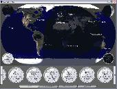
ActiveEarth is a world time clock with a gorgeous day/night merge of NASA's Visible Earth satellite images in flat Maps or a globe, with a row of user-definable clocks along the bottom. These clocks are beautiful, scalable, ticking, analog clocks that come in several styles with many custom settings. Each clock is set to a city of your choice. The program has accurate time zone...
Category: Business & Finance
Publisher: Norris Family Industry, License: Demo, Price: USD $24.95, File Size: 2.8 MB
Platform: Windows
Diffuse maps represent the absorption of light.
Diffuse Maps represent the absorption of light. Diffuse Maps are what people call "textures". They are the color textures or photographic textures usually applied to 3d models.
ShaderMap creates displacement Maps using the light data stored inside of diffuse Maps. Evenly lit diffuse Maps generally create better quality Maps with ShaderMap.
Category: Home & Education / Miscellaneous
Publisher: Rendering Systems Inc., License: Freeware, Price: USD $0.00, File Size: 4.0 MB
Platform: Windows
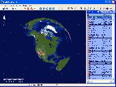
This educational program brings a plethora of geographic information right to your desktop. After you launch Earth Explorer, you'll be greeted by a 3D rendition of the Earth spinning in space. To the right of the globe sits a table of information on countries, cities, and islands. Simply clicking on one of the entries shows you its location on the globe, and scrolling over the...
Category: Audio
Publisher: Motherplanet, Inc, License: Shareware, Price: USD $59.95, File Size: 7.4 MB
Platform: Windows, Mac
NOVA Maps provides appraisers and appraisal users with complete, high-resolution location Maps (also known as “street Maps”) for forms and addenda in seconds. NOVA Maps even automatically places labels for subject properties and comparables.
For just pennies per map and with just a click of the mouse, users have access to the entire United...
Category: Home & Education / Miscellaneous
Publisher: Day One, License: Demo, Price: USD $0.00, File Size: 5.7 MB
Platform: Windows
WW2D allows you to explore Earth using satellite imagery, topographic Maps and image from other data sources also providing large placenames and boundaries database and allowing you to install community-made add-ons for even more info about our planet.
Category: Business & Finance / Business Finance
Publisher: Vitaliy Pronkin, License: Freeware, Price: USD $0.00, File Size: 6.6 MB
Platform: Windows
GeoFeeder is a GeoRSS viewer in Adobe AIR.
GeoFeeder is a GeoRSS viewer in Adobe AIR.
It focuses on the map (in all flavors: Virtual Earth, Google Maps, Yahoo Maps, OpenStreetMap …) and on the data. An advanced, html-capable tooltip window displays the feed-entries’ information. A list allows for simple sorting by title. It’s feed “database” is shared between all...
Category: Internet / Misc. Plugins
Publisher: Markus Schorer, License: Freeware, Price: USD $0.00, File Size: 565.0 KB
Platform: Windows
The Earth is probably the best planet I?
The Earth is probably the best planet I?ve ever been to, so I like to keep abreast of what?s going on in the world. I found this desktop background great for monitoring cloud cover, the advance of day and night and nocturnal lights around the globe.
Category: Desktop Enhancements / Wallpaper
Publisher: codefromthe70s.org, License: Freeware, Price: USD $0.00, File Size: 6.2 MB
Platform: Windows
The Earth Screensaver is a screensaver for your computer that will help you relax and get away from your everyday routine by means of watching our planet from space. You will see the Earth with its continents, seas and oceans, clouds and lights of big cities, notice the miraculous glow of the atmosphere, feel the endless space filled with countless stars and mysterious nebulae....
Category: Desktop Enhancements / Screensavers
Publisher: IndaSoftware, License: Shareware, Price: USD $14.00, File Size: 1.0 MB
Platform: Windows