Free Downloads: Elevation View
Do you feel that the standard tracks (Speed, Elevation, Heart rate, .
Do you feel that the standard tracks (Speed, Elevation, Heart rate, ...) are sometimes not enough?
This plugin lets you add your own tracks to activities: calculated power vs. measured power, Elevation before applying an Elevation correction, power from a second power meter (e.g. an iBike), ...
You can as well use it to "stow away" tracks before...
Category: Audio / Utilities & Plug-Ins
Publisher: Old Man Biking's SportTracks Plugins, License: Shareware, Price: USD $6.89, File Size: 1004.2 KB
Platform: Windows
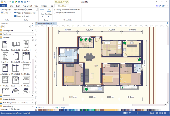
xCAD Interior Design is a tool for planning and visualizing of interior designs.
xCAD Interior Design is a tool for planning and visualizing of interior designs. Modern concepts and software technologies are used in order to enable a user friendly and efficient planning of furniture and designing of rooms. The software supports you when drafting a design using the assistant in 3D with floor plan View and Elevation View and extensive object libraries....
Category: Multimedia & Design / Image Editing
Publisher: xCAD Solutions GmbH, License: Shareware, Price: USD $1795.00, File Size: 62.3 MB
Platform: Windows
Create the GeoDatabase for the entire world. This program create the geographical location Latitude, Longitude, and Altitude (Elevation) for every city, village, region, state, county in the World. The program crawls the data from the website www.heavens-above.com which collect data from US Geological Survey for the USA (and dependencies) and The National Imaging and Mapping Agency for...
Category: Software Development
Publisher: Mewsoft, License: Freeware, Price: USD $0.00, File Size: 1.1 MB
Platform: Windows
RackTools® software increases the efficiency of your business by allowing engineers and salespeople to quickly and easily specify Middle Atlantic Products, and create accurate rack Elevation, plan, side and rear View drawings, purchase orders, and quotes in minutes.
This innovative software utilizes the familiar drag-and-drop interface for creating scale system...
Category: Business & Finance / Business Finance
Publisher: Middle Atlantic Products, License: Freeware, Price: USD $0.00, File Size: 139.7 MB
Platform: Windows
Floor Plan Maker is perfect not only for professional-looking floor plan, office layout, home plan, seating plan, but also garden design, fire and emergency plan, HVAC, Elevation diagram... and that is just the beginning! Floor Plan Maker is inclusive software supporting to produce more than 13 types of floor plans. It can be applied to design floor plan, home plan, office layout,...
Category: Multimedia & Design / Graphics Viewers
Publisher: EdrawSoft, License: Shareware, Price: USD $99.00, File Size: 61.7 MB
Platform: Windows
LocalConnect is the included application for converting and uploading Vectors, Images, Maps, and Elevation to GISRoam.
LocalConnect includes tools to automatically convert your source data to GISRoam formats and projections in the following formats:
* Elevation in the form of DTED, DEM, ARCGrid, GEOTIFF, SRTM, XYZ Grid, and BIL.
* Imagery in the form of MRsid,...
Category: Internet / File Sharing
Publisher: Cogent3D, License: Freeware, Price: USD $0.00, File Size: 26.4 MB
Platform: Windows
 Shareware
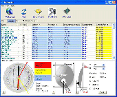
SatHunter is a program for calculating the orientation of a satellite antenna. SatHunter contains all the necessary information for adjusting the satellite antenna to the selected satellite. The adjustment is made with the help of available tools (a compass or a protractor, a plumb, a tape measure) and requires neither expensive equipment nor deep knowledge about satellite television....
Category: Home & Education / Astrology & Numerology
Publisher: Protectedsoft Ltd., License: Shareware, Price: USD $29.95, File Size: 5.4 MB
Platform: Windows
SatCalc is a free software which calculates Azimuth and Elevation for geostationary satellites used for television broadcast.
Features include the calculation of the LNB skew and calculation of sun outage which occurs in spring and fall. The calculated data is presented graphically and can also be printed out and exported to HTML or CSV.
A list of Longitude...
Category: Business & Finance / Applications
Publisher: Martin Kirisits, License: Freeware, Price: USD $0.00, File Size: 1.6 MB
Platform: Windows
FlashPoints is a tool for creating and managing points Groups (topographic points for example). FlashPoints allows you to : * import/export points coordinates from and to a file * create points and their attributes "Number", "Elevation" and "Description" by clicking * modify the points Elevation * modify the height and rotation of the attributes *...
Category: Multimedia & Design
Publisher: DeliCAD, License: Shareware, Price: USD $49.00, File Size: 1.2 MB
Platform: Windows
Data Only
IP2Location IP-COUNTRY-REGION-CITY-LATITUDE-LONGITUDE-ZIPCODE-TIMEZONE-ISP-DOMAIN-NETSPEED-AREACODE-WEATHER-MOBILE-Elevation-USAGETYPE is commercial IP geolocation database that translates IP address to country, region, city, latitude, longitude, zip code, time zone, ISP name, domain name, net speed, area code, IDD code, weather, mobile, Elevation and usage type. Developers use...
Category: Internet / Tools & Utilities
Publisher: IP2Location.com, License: Data Only, Price: USD $3399.00, File Size: 94.5 MB
Platform: Windows
You can enter your City/State OR Zipcode and it outputs a lot of useful information like Azimuth, Elevation, Latitude, Longitude, and Magnetic Deviation. It also has a text database for the satellites that makes it easy to modify satellite names and easy to add or delete satellites.
Category: Home & Education / Miscellaneous
Publisher: NeuroSoft, License: Freeware, Price: USD $0.00, File Size: 1.6 MB
Platform: Windows
The Datgel Survey Tools gINT Add-In consists of a range of utilities for the processing and querying of 3D surfaces, alignments and tidal data.
1. Set Coordinate Chainage Offset Tool: Calculates the coordinates to/from chainage and offset based on alignment data.
2. Grid File Pre-processing Tool: Pre-processes surface files to produce perfect grids, slice up over sized grids,...
Category: Business & Finance / Business Finance
Publisher: Datgel, License: Shareware, Price: USD $0.00, File Size: 0
Platform: Windows
VisualGPS incorporates many advanced features found in professional programs.
VisualGPS incorporates many advanced features found in professional programs. Its sole purpose is to display graphically specific NMEA 0183 sentences and show the effects of selective availability (SA).
Main Features:
- Azimuth and Elevation Graph - View all satellites that are in View. Each satellite identifies its pseudo random number (PRN) and...
Category: Home & Education / Miscellaneous
Publisher: VisualGPSLLC, License: Freeware, Price: USD $0.00, File Size: 1.7 MB
Platform: Windows
Astro Helper will tell you the angle of Elevation above the horizon (altitude) and the direction in degrees from North (Azimuth) of the selected objects. It will simultaneously display the coordinates of 22 objects from a database of over 22,000 objects. With these coordinates you can point your Dobsonian mounted telescope or other "Alt/Az" mounted scope. If you have an...
Category: Home & Education / Astrology & Numerology
Publisher: Mark Casazza Consulting, License: Freeware, Price: USD $0.00, File Size: 3.3 MB
Platform: Windows
CardioVex Holter gives you simultaneous analysis of ECG arrhythmia in three channels and simultaneous analysis of the ST segment in the three channels (depression, Elevation and slope).
You also get 24 hs a day cardiac frequencies graphics, ventricular incidences, supraventricular incidences and ST segment for each channel.
Main Features:
- R-R, ST nd PR...
Category: Home & Education / Health & Nutrition
Publisher: Veccsa S.A., License: Shareware, Price: USD $0.00, File Size: 0
Platform: Windows
Geographic databases management and exploitation, attribute-based and spatial queries, several join types, several classification methods, thematic cartography, statistics and geo-statistics, spatial analysis, interpolations, digital Elevation models, remote-sensing and image processing, simulation, operational research, interactive metric measurements
Category: Home & Education / Miscellaneous
Publisher: IRD, License: Freeware, Price: USD $0.00, File Size: 14.2 MB
Platform: Windows
AutoDEM (aka as AutoMNT) is a freeware GIS software to create Digital Elevation Models (DEM) from scanned topographic maps for Windows.
Through different data layers (map, contours, DEM, etc.), AutoDEM provides many tools for :
-Topographic map analysis
-Contour lines extraction and reconstruction
-Contours to DEM interpolation and DEM analysis
-DEM to TIN...
Category: Multimedia & Design / Animation
Publisher: Joachim Pouderoux, License: Freeware, Price: USD $0.00, File Size: 27.6 MB
Platform: Windows
WinPilot 3D is flight analysis and planning software, that lets you zoom in from satellite altitude into any place on Earth, leveraging Landsat satellite imagery and Shuttle Radar Topography Mission Elevation data. WinPilot 3D lets you experience Earth terrain in visually rich 3D, just as if you were really there. WinPilot 3D also shows airspace in 3D, and contains world-wide database of...
Category: Home & Education / Miscellaneous
Publisher: WinPilot, License: Shareware, Price: USD $59.00, File Size: 3.8 MB
Platform: Windows
Bonus Content - Garage Items has the following features :
- Create detailed Floor plans, Elevation views and Cross-sections
- Visualize and design with 3D models and virtual tours
- Choose from over 18,000 Library items including
CAD Details and name
brand manufacturers
- Use automated building tools, like Automatic Framing and Roof Generation
Category: Home & Education / Miscellaneous
Publisher: Chief Architect Inc, License: Freeware, Price: USD $0.00, File Size: 3.0 MB
Platform: Windows
Introducing you AEC Terrain interface which is designed to simplify terrain management and 3D-modeling. AEC Terrain creates Digital Elevation Model from multiple input point files on AutoCAD graphic editor. All purpose multi-level pads, road alignments, mining applications and airfields can be generated on the terrain on different layers with different slope parameters for CUT and FILL...
Category: Business & Finance / Project Management
Publisher: AEC Logic Private Limited, License: Shareware, Price: USD $750.00, File Size: 16.3 MB
Platform: Windows
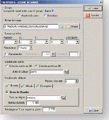
With EME System helps to track the moon or any selected radio source with a high accurate (16 bits) Azimuth/Elevation display (runs also without the interface) and a complete real time dialogue with the hardware interface to point your antenna toward the moon or the selected source with the same accuracy.
Category: Internet / Misc. Plugins
Publisher: F1EHN, License: Freeware, Price: USD $0.00, File Size: 3.0 MB
Platform: Windows
SoftPlot is a graphical design program that makes it easy to drag-and-drop lighting fixtures, trusses, and other elements on the design surface. With this tool you can take a bird-eye's View and see your design in Plan, Cross Section, and Elevation views to make sure all your sight-lines and focuses are correct.
SoftPlot will also manage your paperwork from gel lists to...
Category: Multimedia & Design / Image Editing
Publisher: Stage Research, License: Shareware, Price: USD $0.00, File Size: 0
Platform: Windows
With HD View, you can view and interact with very large images on the Web.
With HD View, you can View and interact with very large images on the Web. HD View supports smooth panning and zooming, as well as appropriate viewing perspectives as you zoom in and out. HD View also makes creating and hosting your own HD View images easy. HD View is available as a plug-in for Windows-based browsers, including Internet Explorer and...
Category: Internet / Browser Accessories
Publisher: Microsoft Research, License: Shareware, Price: USD $0.00, File Size: 0
Platform: Windows

The database includes total of 17 data fields which consists of:
ZIP Code, Classification, Primary Record, City, City Alias Name, City Type, Mailing Name, State, State FIPS, Latitude, Longitude, Elevation, Area Code, County Name, County FIPS, Time Zone & Day Light Saving.
The complete database contains over 80,000 precise records. The sample database and the full database...
Category: Web Authoring / Web Design Utilities
Publisher: IGEOCODE, License: Demo, Price: USD $25.95, File Size: 1.2 MB
Platform: Windows, Mac, Palm
Prog Finder was designed to help users conveniently adjust their Terristeral antenna and Satellite dish.
This program is designed simply enough. Even a novice can easily understand how to modify its options. The interface is user-friendly, and the main buttons are organized in such a manner, as to easily guide you through the entire configuration process. Furthermore, this utility...
Category: Business & Finance / Applications
Publisher: ProgDVB, License: Freeware, Price: USD $0.00, File Size: 6.4 MB
Platform: Windows