Free Downloads: Garmin Bluechart Atlantic
KMLCSV Converter is a tool that enables you to convert the KML file generated from Google Earth (free version) into a formatted CSV file (and vice versa). This CSV file can then be uploaded into your Garmin GPS by using Garmin POI Loader, which can be downloaded for free. This allows you to plot all the custom point of interests (POI) with Google Earth first. Then, you can...
Category: Business & Finance / Calculators
Publisher: Choon-Chern Lim, License: Freeware, Price: USD $0.00, File Size: 2.3 MB
Platform: Windows
Moagu: The Mother Of All GPS Utilities.
Moagu: The Mother Of All GPS Utilities.
You can convert USGS topographic maps, aerial/satellite imagery, and any other raster map imagery for use on Garmin handled GPS units.
Garmin maps have been in a "vector" format; Moagu creates maps using a "bitmap" format.
Category: Home & Education / Miscellaneous
Publisher: Moagu, License: Shareware, Price: USD $19.95, File Size: 38.2 MB
Platform: Windows
RackTools® software increases the efficiency of your business by allowing engineers and salespeople to quickly and easily specify Middle Atlantic Products, and create accurate rack elevation, plan, side and rear view drawings, purchase orders, and quotes in minutes.
This innovative software utilizes the familiar drag-and-drop interface for creating scale system drawings...
Category: Business & Finance / Business Finance
Publisher: Middle Atlantic Products, License: Freeware, Price: USD $0.00, File Size: 139.7 MB
Platform: Windows
The GPS map will help you give you with turn by turn directions to your destination using a POI, city point and/or longitude and latitude.It has the ability to preplan driving destinations before getting into your car. Compatible with ALL Garmin GPS units. Don't pay more than US$10 per day when you already own a Garmin, this is the most comprehensive GPS map available at such...
Category: Home & Education / Miscellaneous
Publisher: GPSTravelMaps.com, License: Shareware, Price: USD $0.00, File Size: 0
Platform: Windows
MetroGold is a Windows tool with which you can upgrade your Garmin MetroGuide Europe or Metroguide North America installation. After the upgrade it's possible to include routing calculation data in your upload of maps to your GPS. No extra software, apart from Mapsource, is needed, you can transfer the maps with Mapsource.
Category: Utilities / Misc. Utilities
Publisher: Geodude, License: Shareware, Price: USD $0.00, File Size: 0
Platform: Windows
PoiEditor is a software solution package for downloading and customizing road safety data.
PoiEditor is a software solution package for downloading and customizing road safety data. The software makes it easy to stay up to date with the latest road safety data also know as POI's(Points of interest), it also applies your personal preferences to the downloaded data. The PoiEditor also sends the data to your Garmin device or SSD Card by utilizing the Garmin Poi loader...
Category: Internet / Misc. Plugins
Publisher: Tinus Strauss, License: Shareware, Price: USD $12.59, File Size: 2.7 MB
Platform: Windows
DNRGarmin is a smart tool used to directly transfer data between Garmin GPS handheld receivers and various GIS software packages.
DNRGarmin was built to provide users the ability to directly transfer data between Garmin GPS handheld receivers and various GIS software packages. Using DNRGarmin a user can use point features (graphics or shapefile) and upload them to the...
Category: Utilities / Misc. Utilities
Publisher: GIS Section, Minnesota Department of Natural Resources, License: Freeware, Price: USD $0.00, File Size: 11.3 MB
Platform: Windows
Fire and Ice - the unique island in the North Atlantic: geysir, waterfalls, glaciers, Iceland horses, iceberg lagunes and birds in incredible colours. Twenty impressive pictures in high quality resolution.
Category: Desktop Enhancements / Screensavers
Publisher: flippi.net, License: Freeware, Price: USD $0.00, File Size: 2.8 MB
Platform: Windows, Mac, VISTA
The purpose of this software is provide support for cartographic formats like Garmin® IMG, or Polish cGPSmapper files. Provides a plataform for designing plugins that allow increase the features of the application, such as AVL support and monitoring.
This software allow the user to simplify certain tasks that require cartographic support. In this situation we offer a...
Category: Home & Education / Miscellaneous
Publisher: Movilbit, Inc., License: Shareware, Price: USD $18.00, File Size: 3.7 MB
Platform: Windows
AdriaROUTE Lite version of map is made without Garmin NT technology so users with older device can use AdriaROUTE map. Some of devices that not support NT technology are: (eTrex Legend, eTrex Vista, eTrex LegendC, eTrex VistaC, GPSMAP 60C, GPSMAP 60CS, CPSMAP 76C, GPSMAP 76CS, iQue3600; iQue M4; iQue M5..).
Category: Utilities / Misc. Utilities
Publisher: Navigo Sistem d.o.o., License: Freeware, Price: USD $0.00, File Size: 149.6 MB
Platform: Windows
Palm Coast, Florida is situated in the eastern portion of Flagler County, which is located on the Atlantic coast, in the heart of Northeast Florida, equidistant between the cities of Jacksonville and Orlando. The City of Palm Coast covers an area of approximately 50 square miles. Palm Coast offers uncrowded beaches, tranquil waterways, wonderful nature parks and gardens, Championship...
Category: Desktop Enhancements / Screensavers
Publisher: Sierra Vista Software, License: Freeware, Price: USD $0.00, File Size: 1.7 MB
Platform: Windows
The Windows PC shareware program for Garmin and Magellan GPS receivers.
The Windows PC shareware program for Garmin and Magellan GPS receivers.
Main Features:
- transfer your waypoints, routes, and tracks from and to the GPS receiver, and save it on your computer disk
- review your waypoints
- enter and edit your waypoints
- define your routes and get the estimated traveling time
- review and edit your...
Category: Home & Education / Miscellaneous
Publisher: Heinrich Pfeifer, License: Freeware, Price: USD $0.00, File Size: 2.9 MB
Platform: Windows

Let the waves come and animate your wallpaper. Feel as if you were on the sand. .
Category: Desktop Enhancements / Wallpaper
Publisher: Selten, License: Shareware, Price: USD $3.95, File Size: 3.6 MB
Platform: Unknown
 Shareware
Are you ready for an exciting journey across the Atlantic Ocean? This 3D Screensavers will take you on board a magnificent flagship. Named after Queen Victoria this beautiful vessel is the symbol of power and might of the Royal Navy. Feel the gentle breeze blowing in your face and enjoy the peaceful beauty of the boundless ocean. Armed with guns and cannons Victoria fearlessly ploughs...
Category: Desktop Enhancements / Screensavers
Publisher: Teddy Games, License: Shareware, Price: USD $9.95, File Size: 9.0 MB
Platform: Windows
MapToaster Topo New Zealand is New Zealand's only topographical mapping suite, with options for your computer and Garmin GPS, including:
- all the rich detail of the LINZ topo maps - seamless across NZ. Now includes Topo50 and Topo250 map series.
- 1:50,000 though 1:2 million scale maps on your PC and 1:50,000 on your GPS
- integrated aerial and satellite...
Category: Home & Education / Miscellaneous
Publisher: Integrated Mapping Ltd, License: Shareware, Price: USD $0.00, File Size: 38.5 MB
Platform: Windows

Are you ready for an exciting journey across the Atlantic Ocean? This 3D Screensavers will take you on board a magnificent flagship. Named after Queen Victoria this beautiful vessel is the symbol of power and might of the Royal Navy. Feel the gentle breeze blowing in your face and enjoy the peaceful beauty of the boundless ocean. Armed with guns and cannons Victoria fearlessly ploughs...
Category: Desktop Enhancements / Screensavers
Publisher: Digital Minds Software, License: Shareware, Price: USD $9.95, File Size: 9.0 MB
Platform: Windows
Alex was making just another routine run across the Atlantic Ocean in his cargo plane when his girlfriend's lucky talisman started to glow. Moments later, as his ride dove toward choppy waters, he found himself parachuting to the sandy expanse of an uncharted island.
Masters of Mystery: Blood of Betrayal opens with Detective Carrie Chase enjoying a glass of fine wine with an...
Category: Audio / Utilities & Plug-Ins
Publisher: dvdripnburn.com, License: Freeware, Price: USD $0.00, File Size: 1.1 MB
Platform: Windows

The setup has install and uninstall features to be easy configured. Find other product on http://www. selten-software.
Category: Desktop Enhancements / Screensavers
Publisher: Selten, License: Shareware, Price: USD $4.95, File Size: 1.9 MB
Platform: Unknown
Military Overlay Editor (MOLE) is a set of COM components for developers to create custom applications that support Department of Defense (DoD) MIL-STD-2525B and the North Atlantic Treaty Organization (NATO) APP6a specifications.
MOLE allows you to easily create, display, and edit military symbology in your maps. It enhances the effectiveness of your command and control (C2) and...
Category: Home & Education / Miscellaneous
Publisher: Environmental Systems Research Institute, Inc., License: Shareware, Price: USD $0.00, File Size: 0
Platform: Windows
The setup has install and uninstall features to be easy configured. Find other product on http://www. selten-software.
Category: Desktop Enhancements / Screensavers
Publisher: Selten, License: Shareware, Price: USD $4.95, File Size: 1.9 MB
Platform: Unknown
GPSMapEdit is an application designed for visual authoring of GPS-maps in various cartographic formats: Polish format, Garmin MapSource, Lowrance MapCreate, Navitel Navigator (navigation software for Windows Mobile, Android, Symbian, iPhone), ALAN Map 500/600, Holux MapSho, and custom POIs and speedcams.
The program may also load and convert GPS-tracks, waypoints and routes...
Category: Utilities / Misc. Utilities
Publisher: Konstantin Galichsky, License: Shareware, Price: USD $65.00, File Size: 2.4 MB
Platform: Windows
The G600 Trainer is partitioned into three downloads, including a Base Installation, and Add-ons for Garmin SVT™ Synthetic Vision Technology and FlightCharts®. The Base installation should be installed first. The Base installation is required to be installed first.
Category: Games / Simulations
Publisher: Garmin Ltd or its subsidiaries, License: Shareware, Price: USD $159.00, File Size: 654.4 MB
Platform: Windows
Northwest Trails is a mapset of trails designed for upload to any map-enabled Garmin GPS receiver.
Northwest Trails is a mapset of trails designed for upload to any map-enabled Garmin GPS receiver. It is more than just a mapset, though; it is also a community effort initiated to record and collect GPS data for trails in the Northwest (Washington, Idaho, Oregon, Montana, Wyoming, Alaska, British Columbia and Alberta) and provide that data for general public use.
The mapset...
Category: Internet / Misc. Plugins
Publisher: Jon F. Stanley, License: Freeware, Price: USD $0.00, File Size: 31.7 MB
Platform: Windows
GeoVisu is a program that displays georeferenced data (images, graphics) and downloads data recorded by some GPS devices.
GeoVisu has a "Moving map" navigation function, which can be used with any NMEA 0183 compatible or Garmin USB GPS device.
Main features:
- Displays georeferenced image formats : GeoTiff, ECW and ECWP, MrSID, OziExplorer...
Category: Multimedia & Design / Graphics Viewers
Publisher: GeoVisu, License: Freeware, Price: USD $0.00, File Size: 1.7 MB
Platform: Windows
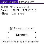
Card Reader allows to use Palm-powered handhelds as an ordinary USB card reader for quick and easy file exchange. It has the unique ability to export the card in the background mode allowing you e.g. to transfer MP3s simultaneously with web browsing. Supported devices : palm T|X; Treo 600; Treo 650; Tungsten|T5; Tungsten|T3; Tungsten|E2; Tungsten|E; GSL Xplore M68; Tungsten|C; Zire 31; Zire...
Category: Utilities
Publisher: Mobile Stream, License: Shareware, Price: USD $11.95, File Size: 29.0 KB
Platform: Palm