Free Downloads: Garmin Fit Files Software
Moagu: The Mother Of All GPS Utilities.
Moagu: The Mother Of All GPS Utilities.
You can convert USGS topographic maps, aerial/satellite imagery, and any other raster map imagery for use on Garmin handled GPS units.
Garmin maps have been in a "vector" format; Moagu creates maps using a "bitmap" format.
Category: Home & Education / Miscellaneous
Publisher: Moagu, License: Shareware, Price: USD $19.95, File Size: 38.2 MB
Platform: Windows
The GPS map will help you give you with turn by turn directions to your destination using a POI, city point and/or longitude and latitude.It has the ability to preplan driving destinations before getting into your car. Compatible with ALL Garmin GPS units. Don't pay more than US$10 per day when you already own a Garmin, this is the most comprehensive GPS map available at such...
Category: Home & Education / Miscellaneous
Publisher: GPSTravelMaps.com, License: Shareware, Price: USD $0.00, File Size: 0
Platform: Windows
Whether you're exploring new coastline or cruising your favorite bay, BlueChart Atlantic contains the most detailed marine cartography around. These electronic nautical maps give you peace of mind when navigating offshore.
The BlueChart Atlantic CD-ROM includes coverage for several offshore regions — select one of these regions to view and download charts with this purchase....
Category: Home & Education / Miscellaneous
Publisher: Garmin Ltd or its subsidiaries, License: Shareware, Price: USD $0.00, File Size: 0
Platform: Windows
AdriaROUTE Lite version of map is made without Garmin NT technology so users with older device can use AdriaROUTE map. Some of devices that not support NT technology are: (eTrex Legend, eTrex Vista, eTrex LegendC, eTrex VistaC, GPSMAP 60C, GPSMAP 60CS, CPSMAP 76C, GPSMAP 76CS, iQue3600; iQue M4; iQue M5..).
Category: Utilities / Misc. Utilities
Publisher: Navigo Sistem d.o.o., License: Freeware, Price: USD $0.00, File Size: 149.6 MB
Platform: Windows
MapToaster Topo New Zealand is New Zealand's only topographical mapping suite, with options for your computer and Garmin GPS, including:
- all the rich detail of the LINZ topo maps - seamless across NZ. Now includes Topo50 and Topo250 map series.
- 1:50,000 though 1:2 million scale maps on your PC and 1:50,000 on your GPS
- integrated aerial and satellite...
Category: Home & Education / Miscellaneous
Publisher: Integrated Mapping Ltd, License: Shareware, Price: USD $0.00, File Size: 38.5 MB
Platform: Windows
GPSMapEdit is an application designed for visual authoring of GPS-maps in various cartographic formats: Polish format, Garmin MapSource, Lowrance MapCreate, Navitel Navigator (navigation Software for Windows Mobile, Android, Symbian, iPhone), ALAN Map 500/600, Holux MapSho, and custom POIs and speedcams.
The program may also load and convert GPS-tracks, waypoints and...
Category: Utilities / Misc. Utilities
Publisher: Konstantin Galichsky, License: Shareware, Price: USD $65.00, File Size: 2.4 MB
Platform: Windows
The Windows PC shareware program for Garmin and Magellan GPS receivers.
The Windows PC shareware program for Garmin and Magellan GPS receivers.
Main Features:
- transfer your waypoints, routes, and tracks from and to the GPS receiver, and save it on your computer disk
- review your waypoints
- enter and edit your waypoints
- define your routes and get the estimated traveling time
- review and edit your...
Category: Home & Education / Miscellaneous
Publisher: Heinrich Pfeifer, License: Freeware, Price: USD $0.00, File Size: 2.9 MB
Platform: Windows
GeoVisu is a program that displays georeferenced data (images, graphics) and downloads data recorded by some GPS devices.
GeoVisu has a "Moving map" navigation function, which can be used with any NMEA 0183 compatible or Garmin USB GPS device.
Main features:
- Displays georeferenced image formats : GeoTiff, ECW and ECWP, MrSID, OziExplorer...
Category: Multimedia & Design / Graphics Viewers
Publisher: GeoVisu, License: Freeware, Price: USD $0.00, File Size: 1.7 MB
Platform: Windows
The industry's best value roofing estimation software for fit and strip-and-fit roofing.
The industry's best value roofing estimation Software for Fit and strip-and-Fit roofing.
-Reduce your roof estimating costs now:
- Covers: Rectangular roofs, Mono-pitch roofs and L-shaped roofs
-Add any number of dormers or roof extensions to any roof type
-Add any number of abutments to the building
- Parts for hips and valleys calculated...
Category: Business & Finance / Business Finance
Publisher: Sandens Consulting Limited, License: Shareware, Price: USD $98.27, File Size: 6.7 MB
Platform: Windows
The G600 Trainer is partitioned into three downloads, including a Base Installation, and Add-ons for Garmin SVT™ Synthetic Vision Technology and FlightCharts®. The Base installation should be installed first. The Base installation is required to be installed first.
Category: Games / Simulations
Publisher: Garmin Ltd or its subsidiaries, License: Shareware, Price: USD $159.00, File Size: 654.4 MB
Platform: Windows
OziExplorer is a flamboyant GPS Mapping Software that runs on the PC and works with varieties of GPS receivers such as Garmin, Lowrance, Magellan, Eagle, Brunton, Silva and MLR for the uploading or downloading the waypoints, routes and tracks and most brands of GPS receivers for real time tracking of GPS position.
Using this Software, the user can use maps and...
Category: Internet / Communications
Publisher: Des Newman, License: Shareware, Price: USD $95.00, File Size: 6.8 MB
Platform: Windows
Northwest Trails is a mapset of trails designed for upload to any map-enabled Garmin GPS receiver.
Northwest Trails is a mapset of trails designed for upload to any map-enabled Garmin GPS receiver. It is more than just a mapset, though; it is also a community effort initiated to record and collect GPS data for trails in the Northwest (Washington, Idaho, Oregon, Montana, Wyoming, Alaska, British Columbia and Alberta) and provide that data for general public use.
The mapset...
Category: Internet / Misc. Plugins
Publisher: Jon F. Stanley, License: Freeware, Price: USD $0.00, File Size: 31.7 MB
Platform: Windows
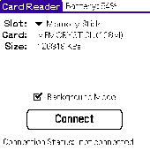
Card Reader allows to use Palm-powered handhelds as an ordinary USB card reader for quick and easy file exchange. It has the unique ability to export the card in the background mode allowing you e.g. to transfer MP3s simultaneously with web browsing. Supported devices : palm T|X; Treo 600; Treo 650; Tungsten|T5; Tungsten|T3; Tungsten|E2; Tungsten|E; GSL Xplore M68; Tungsten|C; Zire 31; Zire...
Category: Utilities
Publisher: Mobile Stream, License: Shareware, Price: USD $11.95, File Size: 29.0 KB
Platform: Palm
Word-Fit is a bilingual (fr,en) crossword puzzle game generator software.
Word-Fit is a bilingual (fr,en) crossword puzzle game generator Software. You may generate as many french or english wordfit crossword puzzles with this crossword game Software. Complete the 20x20 grill with the supplied word list then create a new one in seconds to play again. You may generate as many different grills as you want since it is made randomly from a wordbank....
Category: Games / Misc. Games
Publisher: Cribbage, License: Shareware, Price: USD $10.00, File Size: 1.6 MB
Platform: Windows
KEMET Fit Calculator Software has a method of predicting reliability based on stress and environmental factors has been available for many capacitor types.This calculator Software is intended to follow the calculations spelled out in this handbook for the specific part types that KEMET manufactures
Category: Business & Finance / Applications
Publisher: KEMET Electronics Corp., License: Freeware, Price: USD $0.00, File Size: 2.9 MB
Platform: Windows
LAB Fit is a software for Windows developed for treatment and analysis of experimental data.
LAB Fit is a Software for Windows developed for treatment and analysis of experimental data. At LABFit program you are able to:
1) Treat similar data (grouped and ungrouped dataset, one or two samples);
2) Treat non-similar data;
3) Determine propagated error (error propagation up to eight independent variables);
4) Plot 2D and 3D graph (normal, parametric,...
Category: Home & Education / Science
Publisher: Wilton Pereira da Silva, License: Shareware, Price: USD $60.00, File Size: 3.3 MB
Platform: Windows
RJS Graph produces professional scientific and mathematical graphs.
RJS Graph produces professional scientific and mathematical graphs. You may study the data with a wide range of data analysis tools. Features include the ability to plot data and equations, Fit best Fit curves and splines, and display fitted best Fit curve parameters. Data can be pasted from a spreadsheet or imported from a text file using a wizard.
Category: Home & Education / Mathematics
Publisher: RJS, License: Freeware, Price: USD $0.00, File Size: 3.7 MB
Platform: Windows
This program converts from GPX format to CSV format or vice versa.
This program converts from GPX format to CSV format or vice versa. You can create waypoints in MapSource and then convert them to POI (CSV) Files for download or sharing with others.
You can also convert POI (CSV) Files that others have created, and then edit them in MapSource. Now that the Garmin POI loader supports GPX Files, GPXtoPOI's most...
Category: Business & Finance / Calculators
Publisher: MasterClass, License: Freeware, Price: USD $0.00, File Size: 1.4 MB
Platform: Windows
 Shareware
GPS Mapping Software for Windows, Loading topographic maps, manage GPS devices and more. The Software can be used with various map formats including: GeoTiff, BSB Nautical Charts, AutoCad DXF Files, ESRI Shapefiles. Using calibration you can also use scanned or downloaded JPG, BMP, GIF, PNG and TIF maps. The Software can be used for survey, research, track and trace,...
Category: Home & Education / Science
Publisher: Eye4Software B.V., License: Shareware, Price: USD $75.04, EUR49, File Size: 6.7 MB
Platform: Windows
With JPdfBookmarks, bookmarks can be reordered by dragging them around with the mouse.
With JPdfBookmarks, bookmarks can be reordered by dragging them around with the mouse.
It has a command line and a graphical interface. In the graphical interface you can create different kind of bookmarks, not pointing only at top of page but also at different positions within the page, using Fit page width, Fit page height or Fit whole page options.
Category: Multimedia & Design / Digital Media Editors
Publisher: Flaviano Petrocchi, License: Shareware, Price: USD $0.00, File Size: 0
Platform: Windows
MyGPS is a Freeware Software for the creation and the management of longitude and latitude calibrated maps.
The Software can define points of interest obtaining their coordinates (waypoints), can create routes (routepoints), can visualize track paths (trackpoints).
Using a serial link, points routes and tracks can be shared with "eTrex" and "Geko"...
Category: Home & Education / Miscellaneous
Publisher: GPSInfo, License: Freeware, Price: USD $0.00, File Size: 2.3 MB
Platform: Windows
When you need to exchange data between computers, some Files may appear too large to Fit into the transport media or to be uploaded to the Internet. SplitIt System is a program that is able to split large Files into smaller pieces, adding an executable se
Category: Utilities / File & Disk Management
Publisher: grandutils.com, License: Freeware, Price: USD $0.00, File Size: 35.0 KB
Platform: Windows, Mac, 2K, 2K3

Geocode digital images with latitude, longitude, altitude, and direction information when collecting GIS field data. RoboGEO stamps this information onto the actual photo or writes it to the EXIF headers, allowing you to permanently geotag and link your photos to the GPS coordinates. All writing to the EXIF and IPTC headers is lossless and all of the existing comments (including the MakerNote...
Category: Multimedia & Design
Publisher: Pretek, Inc., License: Demo, Price: USD $34.95, File Size: 6.4 MB
Platform: Windows
Sonic and Tails have crashed into earth and have transformed into humans and changed their name to Fit in. Race to the end of each level destroying enemies and collecting stars on the way. Be careful the evil Dr. Robotnik has followed you to Earth! Use the space bar to jump, and press down plus space bar to do a power spin and use the arrow keys to move!
Sonic Earth is a...
Category: Games / Arcade
Publisher: softendo.com, License: Freeware, Price: USD $0.00, File Size: 7.4 MB
Platform: Windows
Simple yet powerful windows file recovery system to recover Files that have been accidentally erased or were to big to Fit in the Recycle Bin. In Less Than 3.5 Minutes You Can Discover The Quickest & Simplist Method To Recover Your Important Lost Files and Avert a Major Disaster.
Category: Utilities / System Utilities
Publisher: MircSoft Ltd., License: Demo, Price: USD $17.95, File Size: 1.6 MB
Platform: Windows