Free Downloads: Geographical Map
PocketGIS is a powerful mobile Geographical Information System (GIS) for field data capture which can display and edit Map geometry and attributes. PocketGIS brings real GIS functionality to highly portable handheld devices which are lightweight, convenient and have a long battery life.
Category: Utilities / Misc. Utilities
Publisher: Pocket Systems Ltd, License: Shareware, Price: USD $499.00, File Size: 42.8 MB
Platform: Windows
The GeoAze3 geography game is a fun way to learn geography.
The GeoAze3 geography game is a fun way to learn geography. The program features Geographical information, physical and political concise and clear maps for the entire world, and this versatile program is suitable for playing on most computers and under any operating system. The recognizable Windows-style interface is very simple, and anyone from age of 7 to adult can navigate the...
Category: Games / Misc. Games
Publisher: Silverglint, License: Shareware, Price: USD $44.00, File Size: 10.2 MB
Platform: Windows
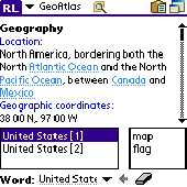
Learn more about countries in the World. Keep this atlas as the reference when you need Geographical information such as country location, neighbours, capital, population, economy, military and more including country Map and flag pictures. Whenever you solve a crossword puzzle, perform study research, watch TV news or just get interested in geography - this atlas helps you with...
Category: Home & Education
Publisher: AbsoluteWord, License: Shareware, Price: USD $19.95, File Size: 4.4 MB
Platform: Palm
A Geographical Simulation and Optimization System (GeoSOS) is a computer-based system capable of simulating, predicting, optimizing, and displaying Geographical patterns and processes. GeoSOS has been developed by Prof. Xia Li and his team at Sun Yat-sen University. GeoSOS is designed in an Object-Oriented Programming (OOP) paradigm. This system is implemented by using the...
Category: Home & Education / Miscellaneous
Publisher: Prof. Xia Li, License: Freeware, Price: USD $0.00, File Size: 11.9 MB
Platform: Windows
Nokia Map Manager is a program that allows you to manage and transfer GPS maps to mobile phone.
Nokia Map Manager is a program that allows you to manage and transfer GPS maps to mobile phone. The Map Manager is for the 6110 Navigator only. The program is provided with scan function to search maps on the computer and DVD. Nokia Map Manager is an additional application and is used together with Nokia PC Suite 6.86 and later versions.
Nokia Map Manager helps...
Category: Internet / Communications
Publisher: Nokia, License: Freeware, Price: USD $0.00, File Size: 0
Platform: Windows
Spitfire is a software tool for the Benefon ESC!
Spitfire is a software tool for the Benefon ESC! GPS/GSM mobile phone which allows users to create and load their own or vendor supplied maps into their handset. Spitfire is low cost and simple to use and can load Map images in a variety of bit Map file formats. It provides tools to geographically calibrate a plain bit Map image and correct distortions introduced by...
Category: Business & Finance / Business Finance
Publisher: Barhop Apps, License: Shareware, Price: USD $39.90, File Size: 2.6 MB
Platform: Windows
Cool Flash Map Maker is a powerful Flash Map software for developing interactive flash mapping solutions and products for Real Estate, Spacial Statistics, Business Locator Applications, Vector USA Map,World Map, Germany Map,ASIA Map, Canada Map, Europe Map, Australia Map, Austria Map, Africa Map, UK Map, South...
Category: Multimedia & Design / Multimedia App's
Publisher: Go2Share, License: Shareware, Price: USD $29.95, File Size: 17.9 MB
Platform: Windows
VisualRoute combines the tools Traceroute, Ping, and Whois into an easy-to-use graphical interface that analyzes Internet connections to quickly locate where an outage or slowdown occurs. In addition, VisualRoute identifies the Geographical location of IP addresses and Web servers on a global Map--key information for security purposes to help identify network intruders and...
Category: Internet / Tools & Utilities
Publisher: Visualware Inc., License: Shareware, Price: USD $49.95, File Size: 3.7 MB
Platform: Windows, Mac
VisualRoute combines the tools Traceroute, Ping, and Whois into an easy-to-use graphical interface that analyzes Internet connections to quickly locate where an outage or slowdown occurs. In addition, VisualRoute identifies the Geographical location of IP addresses and Web servers on a global Map--key information for security purposes to help identify network intruders and...
Category: Internet
Publisher: Visualware Inc., License: Shareware, Price: USD $49.95, File Size: 4.0 MB
Platform: Windows
Anychart is a flexible Macromedia Flash based-solution, which allows you to easily display any sort of data dealing with Geographical locations. It contains United States Maps with Counties, World Map, etc. XML data file and a set of customizable options make AnyChart Maps a universal solution for web developers. AnyChart allows you to create superb, compact, interactive maps....
Category: Software Development
Publisher: AnyChart.Com, License: Shareware, Price: USD $199.00, File Size: 2.8 MB
Platform: Windows, Mac, Linux, Palm,
Geozip calculates distance between US (optionally Canadian) zip codes or Geographical coordinates, latitude and longitude. It does take into account the curvature of the earth for calculating. You can choose miles, kilometers or nautical miles output. Customixation is available if you need more specific applications using the Geozip Geographical distance calculations.
Category: Business & Finance
Publisher: Island Limited, License: Shareware, Price: USD $49.00, File Size: 2.3 MB
Platform: Windows
This is a simple and yet reliable protection from accidentally accessing Internet websites located in at-risk Geographical countries. Save your preferences into a file and load when you need it. 200+ countries and territories. It blocks all TCP/IP and UDP/IP traffic coming out/in from/to computer. Up until recently, the Geographical blocking was only available to large companies...
Category: Internet / Proxy Servers
Publisher: Verigio Communications, License: Shareware, Price: USD $24.95, File Size: 6.8 MB
Platform: Windows
Today, businesses are going online.
Today, businesses are going online. Effective web marketing starts with the thorough analysis of your potential customers' browsing habits, web site effectiveness monitoring and geo-targeting.
Raw web server logs offer a lot of valuable marketing information. The only question is what tool we use to extract this precious data from meaningless lines of alphanumeric characters, which is...
Category: Web Authoring / Web Design Utilities
Publisher: Altstone Software, License: Shareware, Price: USD $49.95, File Size: 12.2 MB
Platform: Windows
Remere's Map Editor is a map editor for the OpenTibia Project which was created by Remere.
Remere's Map Editor is a Map editor for the OpenTibia Project which was created by Remere.
Remere's Map Editor is a Map editor coded in C to be used with OpenTibia. It supports many advanced features such as autobordering and placing of composite objects. Runs under both Linux and Windows using wxWidgets and OpenGL.
Category: Games / Tools & Editors
Publisher: Remere, License: Shareware, Price: USD $0.00, File Size: 4.2 MB
Platform: Windows
Route Tracer is the application that allows you to trace the route over the network between two systems, listing all the intermediate routers a connection must pass through to get to its destination. Route Tracer provides the physical Geographical locations of network servers and routers. It shows the actual route path on both the three-dimensional globe and the flat Map and...
Category: Internet / Tools & Utilities
Publisher: MacSeal.COM, License: Shareware, Price: USD $25.00, File Size: 18.2 MB
Platform: Unknown
 Freeware
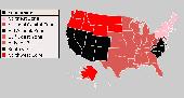
An interactive Flash USA Map with all the features you need for your web site or project. This is the ideal solution for dealer maps, real-estate listings, or visualizing state statistics. Nearly every aspect of the Map is customizable. However, unlike competing products, our Map is very simple to install and edit. Just upload XML and SWF files and embed.
Category: Internet / Flash Tools
Publisher: http://www.flashusamap.com/trial/flashus, License: Freeware, Price: USD $0.00, File Size: 93.8 KB
Platform: Unknown
For many countries house coordinates are present with coverage degrees upto 100 percent.
For many countries house coordinates are present with coverage degrees upto 100 percent. The geo data offered here are in high-precision quality and are present in different coordinate and reference systems. House Coordinates or also called Geo Coded Building Addresses are meaning the connection between the postal addresses of buildings or building complexes and their accurate positions in the...
Category: Business & Finance / Database Management
Publisher: C. Killet Software Ing.-GbR, License: Demo, Price: USD $1420.00, File Size: 234.0 KB
Platform: Windows
Map of Africa is one of the many maps created for GPS TrackMaker.
Map of Africa is one of the many maps created for GPS TrackMaker. You are able to download the installation package from the TrackMaker website. In order to preview the contents of this package, you need to install GPS TrackMaker.
Using the above mentioned application, you will be able to see the Map of Africa. Just click on the "Open Temporary...
Category: Home & Education / Miscellaneous
Publisher: Geo Studio Technology, License: Freeware, Price: USD $0.00, File Size: 18.3 MB
Platform: Windows
This program is an easy to use geographical projection converter.
This program is an easy to use Geographical projection converter. With this program you can convert either manually entered locations or all the locations in a file (the current version only imports ASCII text files for universal compatibility). LOTE develop over 200 regional datums using 24 ellipsoid parameters. This means local datum shifts require less you defined input.
Category: Home & Education / Miscellaneous
Publisher: Ecological Software Solutions, License: Freeware, Price: USD $0.00, File Size: 1.6 MB
Platform: Windows
Program shows you an actual X3 sector-map, with detailed information about most in-game objects.
Program shows you an actual X3 sector-Map, with detailed information about most in-game objects. The Map is based on a log-file that is created with an in-game script (by Andrei[<>Ace]). If you just want to view the standard Map (or if you don’t have the game) the program will work with the included default Map, which was created with an English X3 game...
Category: Games / Misc. Games
Publisher: SUU Design, License: Freeware, Price: USD $0.00, File Size: 1.4 MB
Platform: Windows
New Zealand Map Reference Converter (NZMapConv) is software that LINZ provides to convert Map references between the old NZMS260 Map series and the new NZTopo50 Map series.NZMapConv is a Windows programme designed to convert individual coordinates entered manually.
Category: Multimedia & Design / Media Management
Publisher: Land Information New Zealand, License: Freeware, Price: USD $0.00, File Size: 2.4 MB
Platform: Windows
When the XMAP software is communicating with an XEDE via the comms cable each Map will show, at the top of the Map display, an RPM and load value (x and y axis for the Map) in real time. Also in each Map a yellow highlighted block will show the current position within the Map. Beside the real-time display on each Map are the undo and redo buttons which...
Category: Home & Education / Miscellaneous
Publisher: ChipTorque, License: Freeware, Price: USD $0.00, File Size: 1.7 MB
Platform: Windows
Sig Panama Has :
Digital maps of Panama, Digital Map of Panama-City, digital Map of Taboga, digital Map of Bocas del Toro, digital Map of Colon and Free Zone, digital Map of Contadora Island, digital Map of Coronado, Panama, Zona Libre, Map of Panama, Map of Panama City, Map of Colon, Map of Zona Libre, Map of...
Category: Internet / Misc. Plugins
Publisher: DP Imperial, LLC., License: Freeware, Price: USD $0.00, File Size: 44.9 MB
Platform: Windows
Freeware
Arm Map Explorer recreates all the functionalities of Google Maps on your desktop while expanding them with new extras. Map Explorer lets you locate and view any place on the planet using dynamic interactive maps. These maps are draggable, which means there is no need for you to click and wait for graphics to reload each time you want to view adjacent parts of a Map....
Category: Internet / Flash Tools
Publisher: ArmCode, License: Freeware, Price: USD $0.00, File Size: 5.5 MB
Platform: Windows
LocationTool appears to be a very interesting application.
LocationTool appears to be a very interesting application. It allows one to know latitude, longitude and time zone of towns or cities all around the world.
It has a very simple interface that consists of only one window. This window includes search fields, a list with search results and the world Map. The application allows to search by city name or by its position on the...
Category: Home & Education / Miscellaneous
Publisher: Square One research, License: Freeware, Price: USD $0.00, File Size: 0
Platform: Windows