Free Downloads: Geological Stratification
QuickMag allows you to construct reliable Geological models of magnetic anomalies in a fraction of the time of manual methods. You can choose a Geological style and in seconds QuickMag automatically constructs a 3D model of the magnetic source. On a standard desktop computer, this program will build a realistic 3D Geological model in less than 5 seconds and a full inversion...
Category: Multimedia & Design / Multimedia App's
Publisher: Encom Technology Pty Ltd, License: Demo, Price: USD $0.00, File Size: 50.1 MB
Platform: Windows
GSI3D utilizes a Digital Terrain Model, surface Geological linework and downhole borehole data to enable the geologist to construct cross sections by correlating boreholes and the outcrops to produce a Geological fence diagram. Mathematical interpolation between the nodes along the drawn sections and the limits of the units produces a solid model comprising a stack of triangulated...
Category: Utilities / Misc. Utilities
Publisher: British Geological Survey - Insight, License: Shareware, Price: USD $0.00, File Size: 44.6 MB
Platform: Windows
GeoUtility - Software collection, support for the professionals working in Geological and geotechnical fields.
Software for measurement units conversion, also realizes the conversion for geographical coordinates.
Thrust computation in both static and dynamic conditions.
Category: Audio / Utilities & Plug-Ins
Publisher: Geostru Software, License: Shareware, Price: USD $99.00, File Size: 64.4 MB
Platform: Windows
RockWare StereoStat is an integrated platform for organizing, manipulating, visualizing and interpreting Geological datasets. Functionality includes:
- Flexible and easy-to-user data importer
- Full color plotting
- Comprehensive data manipulation and organization
- Statistical analysis
RockWare StereoStat is must-have software for anyone who...
Category: Business & Finance / Applications
Publisher: RockWare, License: Shareware, Price: USD $299.00, File Size: 11.2 MB
Platform: Windows
GEOrient plots and analyses stereographic projections and rose diagrams of Geological structural data, copied and pasted from other applications, or read from text files. Wind rose options include plotting mean wind data (wind speed/wind frequency/wind energy).
Category: Business & Finance / Business Finance
Publisher: R J Holcombe, License: Shareware, Price: USD $110.00, File Size: 775.8 KB
Platform: Windows
GEOMAGIX uses numerical models of the earth's magnetic field derived from measurements taken by the USGS, the British Geological Survey and other world and government organizations. Each model is stored in an ASCII file with the extension .COF. File names indicate the source and/or region and year of validity. Most models are valid for 5 years from their date, except for the BGS...
Category: Home & Education / Miscellaneous
Publisher: Interpex Limited, License: Freeware, Price: USD $0.00, File Size: 1.2 MB
Platform: Windows
Encom PA provides advanced interactive visualisation in one-, two-, and three-dimensions with support for most geophysical and Geological information types used by companies to cover regional exploration through to mine development.
Encom PA is an interactive geophysical interpretation tool for the analysis of data in point, profile, drillholes, grid, RGB image, remote sensing, GIS...
Category: Multimedia & Design / Graphics Viewers
Publisher: Encom Technology Pty Ltd, License: Freeware, Price: USD $0.00, File Size: 36.5 MB
Platform: Windows
GEOCalculator is a program that can perform calculations on structural geological data.
GEOCalculator is a program that can perform calculations on structural Geological data. You will be able to perform the most common calculations, such as angles between lines or planes, planes bisecting lines or planes, lines with pitch, hade, trend or plunge and more. GEOCalculator can also perform drillhole calculations for oriented, partially oriented, and unoriented cores. For every...
Category: Business & Finance / Calculators
Publisher: R J Holcombe, License: Shareware, Price: USD $112.27, File Size: 3.2 MB
Platform: Windows
A photo slideshow screen saver with beautiful NASA/JPL radar images of Geological formations around the world, including volcanoes, rivers, mountains, and more. The false-color palettes used in these images make them beautiful to look at as well as interesting to study. All photos are 800x600 high-quality images. (a 1024x768 version is also available, see our web site). Other screen...
Category: Desktop Enhancements / Screensavers
Publisher: Cottonwood Software, License: Freeware, Price: USD $0.00, File Size: 1.7 MB
Platform: Windows
Command language audit software - used for audits: * audit identification of duplicates, gaps, audit for outliers, population summaries, data classification and Stratification, univariate statistics, audit sample size computations, percentiles/quartiles, Federal holiday dates, histograms and other.... * testing Benford's law, cumulative monetary amount sampling for audits, interval...
Category: Business & Finance / Business Finance
Publisher: EZ-R Stats, LLC, License: Freeware, Price: USD $0.00, File Size: 11.5 MB
Platform: Windows
This is a fun Educational puzzle of Mediterranean Sea MAP.
This is a fun Educational puzzle of Mediterranean Sea MAP. This is good for Geological Knowledge of a Child. It has a detailed MAP of European Countries, as well as the Mediterranean Sea area. The close countries of the area. the detailed MAP of the countries. This is a fun Educational puzzle of Mediterranean Sea MAP.his is good for Geological Knowledge of a Child. It has a...
Category: Home & Education / Science
Publisher: Mediterranean Cruises 2011, License: Freeware, Price: USD $0.00, File Size: 379.0 KB
Platform: Windows
 Shareware
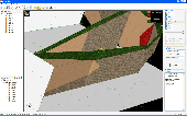
Using VisLog, the user will be able to enter borehole information including but not limited to their depth, coordinates, ground water level, etc. and have a three dimensional interactive view of the underground subject project. The ultimate aim of VisLog is to help users with making an image of the soil layers close to real condition. Input data can be taken from gINT, the most widely used...
Category: Home & Education / Science
Publisher: Novo Tech Software Ltd., License: Shareware, Price: USD $499.00, File Size: 5.5 MB
Platform: Windows
Mine2-4D is MineRP’s premier mine design and planning system.
Mine2-4D is MineRP’s premier mine design and planning system. The Mine2-4D suite forms a fully integrated Mine Planning and Scheduling System that allows engineers to manage the complexity of data from Geological, survey, and mine design layouts by producing complete and detailed mine plans and schedules.
Category: Multimedia & Design / Image Editing
Publisher: MineRP, License: Shareware, Price: USD $0.00, File Size: 0
Platform: Windows
Petroledge is a knowledge system for management of reservoir petrographic information.
Petroledge is a knowledge system for management of reservoir petrographic information. It is an advanced software for capturing, codifying, storing, processing and sharing detailed petrographic descriptions of clastic and carbonate reservoir rocks, based on a high level Geological ontology.
Petroledge integrates artificial intelligence and relational database technology for...
Category: Home & Education / Miscellaneous
Publisher: ENDEEPER, License: Freeware, Price: USD $0.00, File Size: 102.9 MB
Platform: Windows
TriloBase is the ultimate software solution.
TriloBase is the ultimate software solution. This professional, well designed and easy-to-use program for the PC is the ideal tool to manage your precious fossils collection. You can enter all the data like reference number, collecting site, name, Geological period, bibliography, description, taxonomic information, etc...
Category: Home & Education / Hobbies
Multiple photos can be entered with each fossil.
Publisher: Danny Alexandre - Trilobase, License: Demo, Price: USD $0.00, File Size: 31.6 MB
Platform: Windows
Improved English-Polish and Polish-English dictionary available as stand-alone application.
Improved English-Polish and Polish-English dictionary available as stand-alone application. 57 different contexts, such as: Agricultural - American - Archeological - Architectural - Artistic - Astronomical Biblical Biological - Chemical - Commercial - Common - Computer related - Contemptuous - Cooking Cuddlesome - Economical - General - Geographical - Geological - Historical - Humorous -...
Category: Home & Education / E-books & Literature
Publisher: Techland, License: Shareware, Price: USD $0.00, File Size: 0
Platform: Windows
MICRODEM is a freeware microcomputer mapping program written by Professor Peter Guth of the Oceanography Department, U.S. Naval Academy. It requires a 32 bit version of Windows (NT/2000/XP or 95/98/ME). You may freely use MICRODEM with no restrictions.
MICRODEM displays and merges
- digital elevation models
- satellite imagery
- scanned maps
-...
Category: Multimedia & Design / Graphics Viewers
Publisher: Petmar Triilobite Breeding Ranch, License: Freeware, Price: USD $0.00, File Size: 84.9 MB
Platform: Windows
DigiMap is a graphical program for simple digitization of map data to create ASCI files of ordered x,y,z triplets. It is a quick and easy alternative to expensive digitizing tablets and software. Maps (such as Geological, topographic, structural, or isopach) in common Windows file formats (JPEG, PNG, TIFF, PCX, TGA, BMP, WMF, EMF, PSD, GIF) can be opened or scanned in DigiMap and their...
Category: Multimedia & Design / Fonts
Publisher: KWare (Ken Wohletz), License: Freeware, Price: USD $0.00, File Size: 8.4 MB
Platform: Windows
The Colorado Urban Hydrograph Procedure (CUHP) is an evolution of the Snyder unit hydrograph.
The Colorado Urban Hydrograph Procedure (CUHP) is an evolution of the Snyder unit hydrograph. It has been calibrated to the Colorado front range using of data collected by the U.S. Geological Survey beginning in 1969. Data from 30 sites, representing a full range of land uses in the Denver Metro Area, was used to develop empirical relationships between the input hyetograph and observed...
Category: Business & Finance / Database Management
Publisher: Urban Drainage and Flood Control District, License: Freeware, Price: USD $0.00, File Size: 5.4 MB
Platform: Windows
Tesseral-Pro provides more technological approach to building of areal and profile subsurface models for particular seismic survey (2D and 3D) site. It allows increasing of Geological exactness and validity of a model along with simplifying and acceleration of process of creating and modifying of a model and incorporating all available geologic and geophysical data. For this aim,...
Category: Multimedia & Design / Image Editing
Publisher: Tesseral Techonolgies .Inc, License: Demo, Price: USD $0.00, File Size: 35.8 MB
Platform: Windows
Seismic/Eruption: A program for the visualization of seismicity and volcanic activity in space and time. Seismic/Eruption runs in a PC Windows environment. It displays maps of many portions of the world and displays earthquakes and volcanic eruptions in speeded-up time. You can generate your own maps interactively.
Three-dimensional and cross-section views can also be displayed....
Category: Home & Education / Science
Publisher: Alan L. Jones, License: Freeware, Price: USD $0.00, File Size: 15.9 MB
Platform: Windows
Earth Alerts is a Windows-based application that provides alert notifications and information on all natural events currently happening anywhere in the United States (including Guam, Puerto Rico, and the U.S. Virgin Islands). Weather, earthquakes, and volcanos...the kind of stuff our planet dishes out to arouse human curiosity and, occasionally, fear. Fortunately for us, we have organizations...
Category: Home & Education
Publisher: South Wind Technologies, License: Freeware, Price: USD $0.00, File Size: 5.0 MB
Platform: Windows, Vista
Data processing and visualization are rigorously integrated in the OpendTect system.
Data processing and visualization are rigorously integrated in the OpendTect system. Visualization elements can be moved freely through data space to interactively analyze data from stored volumes, or data that are calculated on-the-fly.
Seismic Attributes
Numerous attributes and filters, math & logic, attributes from attributes are supported in the industry's most powerful...
Category: Multimedia & Design / Multimedia App's
Publisher: dGB Earth Sciences, License: Freeware, Price: USD $0.00, File Size: 45.9 MB
Platform: Windows
EarthquakeView is a program that provides real-time information about earthquakes.
EarthquakeView is a program that provides real-time information about earthquakes. Its purpose is to inform you when new quakes occur around the world and provide some basic data about them by means of an interactive map. It is an application intended for informational purposes and its developers say that is not to be used as a tool to 'determine risks'.
After a simple...
Category: Home & Education / Miscellaneous
Publisher: Robomagic Software Corporation, License: Shareware, Price: USD $19.95, File Size: 3.3 MB
Platform: Windows
Create the GeoDatabase for the entire world. This program create the geographical location Latitude, Longitude, and Altitude (Elevation) for every city, village, region, state, county in the World. The program crawls the data from the website www.heavens-above.com which collect data from US Geological Survey for the USA (and dependencies) and The National Imaging and Mapping Agency for...
Category: Software Development
Publisher: Mewsoft, License: Freeware, Price: USD $0.00, File Size: 1.1 MB
Platform: Windows