Free Downloads: Geomatics
License: All | Free
CopanMobile for Palm OS is a very functional and easy-to-use Geomatics engineering tool for computing and managing plane surveying and mapping coordinates. It does numerous coordinate geometry (COGO) calculations, processes and adjusts raw field survey data, computes and adjusts map traverse data, performs map or deed checks, calculates curves, areas and perimeters, performs coordinate...
Category: Multimedia & Design / Multimedia App's
Publisher: Underhill Geomatics Ltd., License: Freeware, Price: USD $0.00, File Size: 341.0 KB
Platform: Palm
CopanMobile for Pocket PC is a very functional and easy-to-use Geomatics engineering tool for computing and managing plane surveying and mapping coordinates. It does numerous coordinate geometry (COGO) calculations, processes and adjusts raw field survey data, computes and adjusts map traverse data, performs map or deed checks, calculates curves, areas and perimeters, performs coordinate...
Category: Business & Finance / Applications
Publisher: Underhill Geomatics Ltd., License: Freeware, Price: USD $0.00, File Size: 341.0 KB
Platform: Windows
Copan for Pocket PC is a very functional and easy-to-use Geomatics engineering tool for computing and managing plane surveying and mapping coordinates.
It does numerous coordinate geometry (COGO) calculations, processes and adjusts raw field survey data, computes and adjusts map traverse data, performs map or deed checks, calculates curves, areas and perimeters, performs...
Category: Multimedia & Design / Multimedia App's
Publisher: Underhill Geomatics Ltd, License: Freeware, Price: USD $0.00, File Size: 662.0 KB
Platform: Windows
Copan for Mobile 6 is a very functional and easy-to-use Geomatics engineering tool for computing and managing plane surveying and mapping coordinates.
It does numerous coordinate geometry (COGO) calculations, processes and adjusts raw field survey data, computes and adjusts map traverse data, performs map or deed checks, calculates curves, areas and perimeters, performs...
Category: Multimedia & Design / Multimedia App's
Publisher: Underhill Geomatics Ltd, License: Freeware, Price: USD $0.00, File Size: 662.0 KB
Platform: Windows
Copan Pro -- for Windows 98, NT, 2000, ME, XP, Vista, or 7 -- is a very functional and easy-to-use desktop/netbook Geomatics engineering tool for computing and managing plane land surveying and mapping coordinates, and drafting survey maps and plans.
It does numerous coordinate geometry (COGO) calculations, processes and adjusts raw field survey data, computes and adjusts map...
Category: Multimedia & Design / Multimedia App's
Publisher: Underhill Geomatics Ltd, License: Demo, Price: USD $650.00, File Size: 9.0 MB
Platform: Windows
GeoImaging Tools for ArcGIS provides ArcGIS users a suite of tools for processing and analyzing imagery in the GIS.
PCI Geomatics is introducing a suite of modules that integrate directly into ArcGIS for achieving common image related tasks.
Users now have the option to save the correction parameters into the Raster Processing Definition (RPDef) format, reducing...
Category: Software Development / Misc. Programming
Publisher: PCI Geomatics, License: Shareware, Price: USD $0.00, File Size: 43.5 KB
Platform: Windows
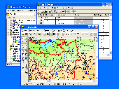
GIS ObjectLand is a universal Geographic Information System for Windows. Key features: - creation of vector-raster maps with arbitrary structure of layers and feature types; - creation of themes. Theme is a user presentation of a map; - control of displaying features depending on the chosen scale; - spatial data input and editing by assigning feature coordinates and also by interactive...
Category: Business & Finance
Publisher: Radom-T, License: Shareware, Price: USD $99.00, File Size: 24.0 MB
Platform: Windows
License: All | Free