Free Downloads: Geotag
License: All | Free
GeoStamper applies the Geotag Icon to geotagged JPEG photos in a lossless fashion (no image degradation during stamping). The Geotag Icon is intended as a web “standard” icon for identifying geotagged content to humans. The stamping process is as simple as dragging and dropping geotagged JPEG files or folders onto the GeoStamper program icon.
Category: Software Development / Misc. Programming
Publisher: Michael G. Lee, License: Freeware, Price: USD $0.00, File Size: 1006.9 KB
Platform: Windows
JCapPM allows you to associate coordinate information (x/y) to each photo.
JCapPM allows you to associate coordinate information (x/y) to each photo. JCapPM can communicate with Google Earth which allows you to Geotag all your files using Google Earth. You can use JCapPM's filter in order to Geotag only filtered photos at once.
Category: Home & Education / Miscellaneous
Publisher: ZeroG Software, License: Freeware, Price: USD $0.00, File Size: 2.5 MB
Platform: Windows
With our locr PC software "locr GPS Photo for Windows" you can manage to automatically Geotag numerous photos simultaneously. You just require a digital camera, a GPS data logger and the application "locr GPS Photo for Windows".
There are two ways to Geotag your photos: The photos can be tagged manually or automatically. For automatic geotagging you need...
Category: Multimedia & Design / Multimedia App's
Publisher: locr, License: Freeware, Price: USD $0.00, File Size: 490.8 KB
Platform: Windows
When posting a photo on your favorite Social Network, online photo gallery, or web page, you are inviting danger.Most smartphones and some cameras made today are equipped with geo tags. Geo tags are imbedded in the picture and use the same concept as GPS.
The geo tag in the photo is a smart tool that allows the photo to be tagged to an exact location. Unless you know where to find and...
Category: Security & Privacy / Other
Publisher: Geotag Security Software, Inc, License: Freeware, Price: USD $0.00, File Size: 2.2 MB
Platform: Windows
Cloudatag means Cloud Data Tag.
Cloudatag means Cloud Data Tag.
Cloudatag manages your photos and videos with Tag Cloud which is a visual depiction of tags. So, you can instantly find or filter out the specific photo on the Cloud or your computer.
Cloudatag provides a better way to Geotag your photos with Geotag Cloud, easy to view and locate them on map.
Cloudatag optimizes Cloud Storage...
Category: Multimedia & Design / Media Management
Publisher: Cloudatag, License: Freeware, Price: USD $0.00, File Size: 4.9 MB
Platform: Windows
- Synchronize with the FREE SplashPhoto Desktop on Mac and Windows
- Add photos, organize, and add titles & notes on the desktop
- Move photos between different albums on the handheld
- Share photos to/from both Flickr and Picasa, both on desktop & iPhone
- Geotag photos so that they can be viewed on a map on Flickr & Picasa
- Set a password and...
Category: Multimedia & Design / Media Catalogers
Publisher: SplashData, License: Freeware, Price: USD $0.00, File Size: 2.8 MB
Platform: Windows
iTag is a utility that allows you to easily add title, description and keyword tags to your digital photos. The data you enter is stored into the actual photo file itself - using the open standards of IPTC and XMP. Many applications can read and write the IPTC/XMP data, but iTag is especially powerful at editing a group of photos all at once. Geocoding your photos is also straight forward...
Category: Multimedia & Design / Media Catalogers
Publisher: iTag Software, License: Freeware, Price: USD $0.00, File Size: 576.9 KB
Platform: Windows
 Demo
Demo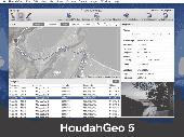
HoudahGeo is a photo geocoding and geotagging tool for Mac. Use HoudahGeo to attach GPS coordinates and location names to your photos. HoudahGeo writes EXIF and XMP geotags to JPEG and RAW image files. This creates a permanent record of where a photo was taken. Just like a GPS-enabled camera. HoudahGeo is the only application that can both write future-proof GPS tags to original images...
Category: Multimedia & Design / Media Catalogers
Publisher: Houdah Software s.à r.l, License: Demo, Price: USD $39.00, File Size: 22.9 MB
Platform: Mac

Geocode digital images with latitude, longitude, altitude, and direction information when collecting GIS field data. RoboGEO stamps this information onto the actual photo or writes it to the EXIF headers, allowing you to permanently Geotag and link your photos to the GPS coordinates. All writing to the EXIF and IPTC headers is lossless and all of the existing comments (including the...
Category: Multimedia & Design
Publisher: Pretek, Inc., License: Demo, Price: USD $34.95, File Size: 6.4 MB
Platform: Windows
License: All | Free