Free Downloads: Gis Data Viewers Convert Illustrator
 Shareware
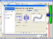
Vextractor is a vectorizer program for transforming raster images into vector formats by building centerlines and outlines. This tool could be used for the vectorizing photo, logotypes and other line art images for use in Vector Graphics Design software. You can also vectorize charts, drawings, maps and schemes for input to CAD or Gis systems. Main features of Vextractor: Input...
Category: Multimedia & Design / Image Editing
Publisher: VextraSoft, License: Shareware, Price: USD $99.95, File Size: 3.0 MB
Platform: Windows
AccuGlobe Desktop 2007,a standardized platform for delivering solutions to the global Gis community, offers even more of what you demand in a desktop Gis application. Combining user-friendly design with significantly increased functionality, AccuGlobe Desktop 2007 gives you greater freedom in analyzing spatial Data. In addition to functioning as the core engine behind many...
Category: Multimedia & Design / Multimedia App's
Publisher: Digital Data Technologies, Inc., License: Freeware, Price: USD $0.00, File Size: 9.8 MB
Platform: Windows
Raster Effects is a plugin for Adobe Illustrator which creates high quality raster images from Illustrator's vector geometry. Renderings are based on smooth spline vector geometry created in Illustrator, and rendered anti aliased to a high definition image suitable for print or web applications.
Category: Multimedia & Design / Multimedia App's
Publisher: Mission Software, License: Shareware, Price: USD $49.95, File Size: 2.2 MB
Platform: Windows
AvisMap Gis Engine is the basic development platform for AvisMap Gis suites, which is a new generation component Gis development platform for Gis application developers.AvisMap Gis Engine Sample Projects is a bundle of sample of different projects that you can see how they work.
Category: Software Development / Misc. Programming
Publisher: AvisMap GIS Technologies, License: Shareware, Price: USD $0.00, File Size: 30.9 MB
Platform: Windows
The CANVAS 9 Advanced Gis Mapping Edition adds native support for Geographic Information System (Gis) Data to Canvas. You can take measurements in geographic coordinates, import industry standard SHAPE and GeoTIFF files into unlimited numbers of automatically aligned overlapping layers and choose among the following options:·2,104 Coordinate Reference...
Category: Multimedia & Design / Multimedia App's
Publisher: ACD Systems, License: Shareware, Price: USD $999.95, File Size: 51.9 MB
Platform: Mac, PPC
AEGIS– the leading GIS software in UK secondary schools.
AEGIS– the leading Gis software in UK secondary schools.
One-off software purchase and free upgrades – no subscriptions.
Brings industry-standard Gis maps to the classroom – Goad town plans, large-scale OS MasterMaps.
Try before you buy with the free AEGIS Viewer download.
Free materials: resources, help sheets,...
Category: Home & Education / Miscellaneous
Publisher: AU Enterprises Limited, License: Shareware, Price: USD $0.00, File Size: 0
Platform: Windows
Shape2Earth leverages freely available and easy to use Geographic Information System (Gis) software to create professional visualizations for viewing in GoogleTM Earth.
Main features:
-Convert Any Shapefile to KML - Shape2Earth reprojects your Data on the fly
-Apply Thematic Symbology to your Data - Color code to display information
...
Category: Multimedia & Design / Image Editing
Publisher: Google, License: Demo, Price: USD $0.00, File Size: 9.5 MB
Platform: Windows
AI to PNG batch image converter is a graphic software that will allow you to Convert Adobe Illustrator (.AI) files to PNG images. Features:Easy batch image converting: select the base folder and destination folder, and click "Batch Convert" button. Support for Adobe Illustrator CS2, CS3, CS4 file formats. Three output file formats: PNG8, PNG24 and PNG32....
Category: Multimedia & Design / Media Management
Publisher: Aleksey Lapshin, License: Freeware, Price: USD $0.00, File Size: 2.0 MB
Platform: Windows
Shareware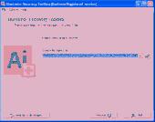
Adobe Illustrator is one of the most popular vector graphics editors in the world and hundred thousands of various people use it every day - from freshmen in the faculties of arts to professional designers. The program has come a long way - from the release of the first version to the latest fourteenth version. Now it offers a lot of tools allowing you to create complex compositions and...
Category: Multimedia & Design / Authoring Tools
Publisher: Recovery ToolBox, License: Shareware, Price: USD $27.00, File Size: 1.1 MB
Platform: Windows
NexGeo Office™ provides all of the functionality needed to organize a Data collection project and manage Data collected from Nexteq GPS/Gis handhelds. It provides tools for viewing, editing and exporting Data to a format suitable for your existing Gis and CAD infrastructure.
Category: Multimedia & Design / Image Editing
Publisher: Nexteq Navigation, License: Freeware, Price: USD $0.00, File Size: 7.4 MB
Platform: Windows
GeoMedia Viewer is an easy to use, FREE Gis software application for desktop viewing and distribution of geospatial Data.It allows an organization to maximize the value of its geospatial Data by extending availability to novice users who wouldn’t otherwise have access because of the barriers of purchasing and learning how to use a full Gis software application.
Category: Multimedia & Design / Graphics Viewers
Publisher: Intergraph Corporation, License: Freeware, Price: USD $0.00, File Size: 115.0 MB
Platform: Windows
Shareware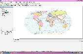
AvisMap Desktop Professional 5 is a professional desktop Gis software for map editing, managing, analysis attribute Data, aid decision-making transactions and output map, print tables, 3D modeling, and other functions. As a complete analysis management tool, AvisMap Despro 5 is applicable in land management, forestry, electric power, telecom, traffic, city pipe network, resource...
Category: Multimedia & Design / Graphics Viewers
Publisher: AvisMap GIS Technologies, License: Shareware, Price: USD $499.00, File Size: 22.2 MB
Platform: Windows
Freeware
Convert ESRI ShapeFiles (.SHP) geolocation Data into AnyMap format to be used with AnyChart. AnyChart Flash Map Converter allows making use of a wide choice of maps with AnyChart Flash Component, a Gis visualization system that recognizes map Data in AnyMap format only. AnyChart Flash Map Converter makes it easy to visualize any geolocation Data without hefty...
Category: Web Authoring / Image Mapping Tools
Publisher: AnyChart.Com, License: Freeware, Price: USD $0.00, File Size: 1.6 MB
Platform: Windows
Map Suite Wpf Desktop Edition takes Gis application development for the Windows desktop to a whole new level.Using the intuitive object model, even developers inexperienced in Geographic Information Systems (Gis) can have fully functional maps working in minutes. With blazing fast rendering performance, powerful mapping features and support for the most popular Data...
Category: Internet / Misc. Plugins
Publisher: ThinkGeo, License: Shareware, Price: USD $4995.00, File Size: 69.1 MB
Platform: Windows
InstantAtlas™ DeskTop, a product developed by GeoWise and which you can buy from ESRI (UK), enables information analysts and Gis professionals to create highly-interactive web solutions that combine statistics and Gis Data to improve visualisation, enhance communication, and engage people in more informed decision making.
InstantAtlas DeskTop is quick and...
Category: Multimedia & Design / Multimedia App's
Publisher: GeoWise, License: Demo, Price: USD $0.00, File Size: 552.0 KB
Platform: Windows
Quantum Gis provides a continously growing number of capabilities provided by core functions and plugins. You can visualize, manage, edit, analyse Data, and compose printable maps. QGIS is an official project of the Open Source Geospatial Foundation (OSGeo). It runs on Linux, Unix, Mac OSX, and Windows and supports numerous vector, raster, and database formats and functionalities.
Category: Home & Education / Miscellaneous
Publisher: qgis.org, License: Freeware, Price: USD $0.00, File Size: 92.2 MB
Platform: Windows
ArcGIS Explorer is a free, downloadable Gis viewer that gives you an easy way to explore, visualize and share Gis information. ArcGIS Explorer adds value to any Gis because it helps you deliver your authoritative Data to a broad audience.
The ArcGIS Explorer Desktop Current User setup is intended for users who do not have administrator access on their...
Category: Desktop Enhancements / Shell & Desktop Managers
Publisher: Environmental Systems Research Institute, Inc., License: Freeware, Price: USD $0.00, File Size: 94.0 MB
Platform: Windows
Cityvu is a 3D GIS data viewer able to load CityGML data format from any compatible data source.
Cityvu is a 3D Gis Data viewer able to load CityGML Data format from any compatible Data source.
Cityvu features 3D hardware rendering using OpenGL with a complete navigation system that allows automated tour of the rendered scene. It has been designed to be used to develop customized software solutions, built on the specific needs. Cityvu supports in...
Category: Multimedia & Design / Graphics Viewers
Publisher: 3D GIS Cityvu, License: Freeware, Price: USD $0.00, File Size: 9.9 MB
Platform: Windows
PocketGIS is a powerful mobile Geographical Information System (Gis) for field Data capture which can display and edit map geometry and attributes. PocketGIS brings real Gis functionality to highly portable handheld devices which are lightweight, convenient and have a long battery life.
Category: Utilities / Misc. Utilities
Publisher: Pocket Systems Ltd, License: Shareware, Price: USD $499.00, File Size: 42.8 MB
Platform: Windows
OpenJUMP is an open source Geographic Information System (Gis), it can read and write shapefiles and simple GML files. It has limited support for the display of images and good support for showing Data retrieved from WFS and WMS web-services. So you can use it as Gis Data Viewer.OpenJUMP has limits in reading very large Data files and has limited support for...
Category: Home & Education / Miscellaneous
Publisher: Jump Pilot Project, License: Shareware, Price: USD $0.00, File Size: 0
Platform: Windows
Cell Illustrator is a software tool that enables biologists to draw, model, elucidate and simulate complex biological processes and systems. It has outstanding drawing capabilities, moreover it allows researchers to model metabolic pathways, signal transduction cascades, gene regulatory pathways as well as dynamic interactions of various biological entities such as genomic DNA, mRNA and...
Category: Web Authoring / Web Design Utilities
Publisher: The University of Tokyo, License: Freeware, Price: USD $0.00, File Size: 7.2 KB
Platform: Windows
Shareware
Total Gis Converter is an affordable converter of Gis files. It converts AEP, GRD, ADF, E00, FLT, APR, SHP, DXF, BT, TOC, RT1, DEM, DLG, ECW, IMG, DGF, GML, SID, MIF, TAB, WOR, DNG, DDF, BIL, TIF, JPEG, TTKPS, TTKGP, TTKLS, LFT, PFT, and TFT files. The target formats are TIFF, PNG, JPEG, BMP. The program can scale your Gis files to optimize their size. Besides, it can slice...
Category: Multimedia & Design / Graphics Viewers
Publisher: Softplicity, License: Shareware, Price: USD $99.90, File Size: 7.6 MB
Platform: Windows
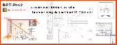
BPT-Pro not only can display measurements of all or parts of segment dimensioning but also measures free curves. Even some professional CAD software cannot give you the dimensions of curved lines, but with BPT-Pro easily measures curved segments. With BPT-Pro2, your Adobe Illustrator software becomes a powerful 2D-CAD program. Compared to other expensive CAD programs, BPT-Pro is...
Category: Multimedia & Design
Publisher: Baby Universe, Inc., License: Shareware, Price: USD $90.00, File Size: 2.0 MB
Platform: Windows
Repair AI file Free enables you to repair Adobe Illustrator files.
Repair AI file Free enables you to repair Adobe Illustrator files. It allows even inexperienced users to easily repair AI files. The step-by-step wizard style interface allows you to use damaged Illustrator file repair tools with ease. The initial step to repair the affected AI file is to select the correct corrupted file by typing the files full path and the full file name in the...
Category: Utilities / File & Disk Management
Publisher: Recovery Toolbox, Inc., License: Freeware, Price: USD $0.00, File Size: 2.3 MB
Platform: Windows
Point Tweaker is a free plugin developed by Stephen Vincent
Point Tweaker is a plug-in for Adobe Illustrator.The software provided is a fully-functional demo version. You may use it without restriction for 14 days. After that it will still work but will no longer edit paths in Illustrator.This plugin allows you to view and finely adjust the coordinates of path points....
Category: Multimedia & Design / Multimedia App's
Publisher: Stephen Vincent, License: Shareware, Price: USD $28.00, File Size: 406.5 KB
Platform: Windows