Free Downloads: Gps Coordinates Excel
Golf GPS Devices toolbar for internet explorer.
Golf Gps Devices toolbar for internet explorer. Find golf Gps devices are great bargain prices. We have all the latest golf Gps devices for sale both new and used. Whether you're looking for the iGolf, Golf Buddy, GolfLogix, SonoCaddie, or SkyCaddie, you can find it here along with their accessories. We are always searching our networks to bring you the best deals on golf...
Category: Internet / Browsers
Publisher: Golf GPS Devices, License: Freeware, Price: USD $0.00, File Size: 1.1 MB
Platform: Windows

Gps Clock Software is a freeware utility that runs on any Windows NT/2000/XP/2003 workstation or server. The software polls time from a standard NMEA Gps time receiver connected to the host PC's serial port and optionally allows time to be synchronised on the host PC. The Gps clock utility polls GPRMC messages from a standard NMEA Gps time receiver. Information...
Category: Utilities
Publisher: ntp time server, License: Freeware, Price: USD $0.00, File Size: 1.9 MB
Platform: Windows
The leading GPS interface tool for Windows!
The leading Gps interface tool for Windows! Gps answers the significant world demand for accurate, viable and cost effective positioning systems. The Geographic Tracker delivers all of the power and utility of Gps to the Windows environment by allowing you to link a Gps receiver to other Microsoft Windows applications through standard Windows DDE messaging.
Category: Home & Education / Miscellaneous
Publisher: Bluemarble Geographics, License: Shareware, Price: USD $0.00, File Size: 0
Platform: Windows
Eye4Software Gps Mapping is a professional Gps mapping software tool that can be used in numerous applications. Use the software to load, view and edit your maps, display your position realtime and record all your movements.
The software will work with almost any Gps and can be used on any desktop, laptop or needbook computer running Windows XP or higher. The...
Category: Home & Education / Miscellaneous
Publisher: Eye4Software B.V., License: Shareware, Price: USD $130.61, File Size: 14.6 MB
Platform: Windows
Are you looking for a Gps tracking system or a Gps tracker but haven't found the one that is ideal for you? Then, look no further as our site has the best deals and information about the kind of Gps tracker you should buy.
Category: Security & Privacy / Other
Publisher: Top GPS Tracking Srl., License: Freeware, Price: USD $0.00, File Size: 722.0 KB
Platform: Windows
The Gps TrackManager is an application for planning routes and managing routes, waypoints and trackpoints.
The application support functions such as: open and save trackpoints files in various formats (GPX, Ozi Trackpoint file, Ozi Waypoint file, NMEA log, EasyGPS file), transmit Trackpoints, Waypoints and Routes to Garmin Gps receivers (Geko 201, GPSmap 60C), saves...
Category: Internet / Communications
Publisher: Frank Hamaekers, Write4u, License: Freeware, Price: USD $0.00, File Size: 4.8 MB
Platform: Windows
System ForAnn GPS allows tracking and location of your phone or phone of your friends / family.
System ForAnn Gps allows tracking and location of your phone or phone of your friends / family. You can watch real-time position of many phones simultaneously.
You can run it even on the cheapest phones with Bluetooth port, which allows the connection of a Gps device.
FAGPS program, in addition to transfer your current position, shows the basic parameters of the route...
Category: Home & Education / Miscellaneous
Publisher: ForAnn Inc., License: Freeware, Price: USD $0.00, File Size: 58.0 KB
Platform: Windows
Immageo is all about making your photos as memorable as when you took them, by geotagging each photo. Immageo is a truly exciting example of what you can and should do with your photo collections. Its more than an album organiser, it embeds map locations and notes into your photos. And when you come to review them Immageo displays them all in context of when and where in the Immageo map,...
Category: Multimedia & Design / Media Catalogers
Publisher: Immageo, License: Freeware, Price: USD $0.00, File Size: 11.0 MB
Platform: Windows
Draw points in AutoCAD and generate 3D models using data in Excel.
XLPoints Plus is the easiest way to massively draw points in AutoCAD and generate 3D models using coordinate data in Excel. Key Features: - Quickly draw points using coordinate data in Excel. - Create new drawings or update existing ones by establishing an open channel with AutoCAD. - Create "true" 3D faces or simply connect all points with a 3D polyline. For the 3D...
Category: Multimedia & Design
Publisher: Productivity Tools, License: Shareware, Price: USD $30.00, File Size: 1.7 MB
Platform: Windows
HsGpsDll is a Windows Dynamic Link Library which provides access to any NMEA-183 compliant Gps receiver via a serial communications port.
HsGpsDll is designed for use from Visual C, C++, Visual C Sharp .NET, Visual Basic or other programming languages, capable of calling DLL functions.
HsGpsDll allows a user application to easily read from a Gps device...
Category: Business & Finance / Business Finance
Publisher: Hillstone Software, License: Shareware, Price: USD $270.58, File Size: 700.6 KB
Platform: Windows
Portable GPS Navigation toolbar for Internet Explorer.
Portable Gps Navigation toolbar for Internet Explorer. Find portable Gps units for your car, truck or minvan from top name brands including Tom Tom, Magellan and Garmin. Discover the world of eBay and shop for portable Gps navigation systems directly from your browser toolbar.
Category: Internet / Browsers
Publisher: Portable GPS Navigation System, License: Freeware, Price: USD $0.00, File Size: 1.1 MB
Platform: Windows
InnerSoft CAD is a add-on for AutoCAD.
InnerSoft CAD is a add-on for AutoCAD. This group of tools will allows you to: Export to a Excel Sheet the values of Area/Length property or Coordinates for various AutoCAD entities. Import from a Excel Sheet the vertex Coordinates for a set of 2D polylines or 3D polylines (you can choose between 3 different methods). You can also import a set of points from...
Category: Multimedia & Design / Multimedia App's
Publisher: InnerSoft, License: Demo, Price: USD $100.00, File Size: 430.0 KB
Platform: Windows
InnerSoft CAD is a add-on for AutoCAD.
InnerSoft CAD is a add-on for AutoCAD. This group of tools will allows you to: Export to a Excel Sheet the values of Area/Length property or Coordinates for various AutoCAD entities. Import from a Excel Sheet the vertex Coordinates for a set of 2D polylines or 3D polylines (you can choose between 3 different methods). You can also import a set of points from...
Category: Multimedia & Design / Multimedia App's
Publisher: InnerSoft, License: Demo, Price: USD $100.00, File Size: 443.0 KB
Platform: Windows
Develop precise, efficient, and reliable location-based services with this multithreaded framework for desktop and mobile devices, including PocketPC, Tablet PC and now Smartphone! Over fifty classes in one lightweight assembly gives you unparalleled features while saving you hundreds of dollars in development and testing.
Gps.NET is loaded with features, including:
NEW:...
Category: Software Development / Components & Libraries
Publisher: StormSource Software, LLC, License: Commercial, Price: USD $98.00, File Size: 4.6 MB
Platform: Windows
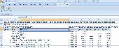
InnerSoft CAD is a add-on component for AutoCAD that allows you to Export the values of an Area/ Length property or Coordinates to an Excel Sheet.
Take measurements on AutoCAD for construction project budgets.
Create, open or save different libraries, which contain a series of AutoCAD drawings (*.dxf or *.dwg) organized by books.
Category: Multimedia & Design / Image Editing
Publisher: InnerSoft, License: Shareware, Price: USD $70.00, File Size: 2.9 MB
Platform: Windows
Never again forget which picture belongs to which place.
Never again forget which picture belongs to which place. Picopolo, the innovative software for travel and Gps, not only organises digital images but also links them to the exact place where they were taken and assigns them to own or provided maps. Coordinates can be allocated either manually or via direct data upload from Gps receivers. Picopolo easily integrates recorded...
Category: Multimedia & Design / Media Catalogers
Publisher: GDMcom mbH, License: Freeware, Price: USD $0.00, File Size: 61.6 MB
Platform: Windows
MyRouteOnline is an easy to use route planner that that allows you to plan routes from Excel spreadsheet. Excel Add-in that uploads addresses and saves time, fuel and money by helping you map multiple locations and find the best route. Online route planning goes far beyond paper maps or a Gps system, it is the only way to find the optimal route for your needs, giving your...
Category: Business & Finance / Business Finance
Publisher: MyRouteOnline, License: Freeware, Price: USD $0.00, File Size: 3.1 MB
Platform: Windows

Gps/J is a console for all Bluetooth-enabled Gps receivers (now with 20000 European towns and cities!), a mobile navigation tool for cellular phone owners and the most affordable and convenient way to use location services.
It is a J2ME application for JSR82-compliant devices, which means "devices with a programmable Bluetooth interface".
Saying...
Category: Home & Education / Miscellaneous
Publisher: GPS/J Project, License: Demo, Price: USD $0.00, File Size: 281.0 KB
Platform: Windows
Gps Tracker Data Logger acts as the server and allows you to collect data from an unlimited number of various Gps trackers simultaneously. The obtained data is processed, uniformed and written to a log file or a database. Also, the program has a set of interfaces so other applications can get data in real time.
Gps Tracker Data Logger can convert data into other...
Category: Internet / Misc. Servers
Publisher: AGG Software, License: Shareware, Price: USD $80.83, File Size: 11.8 MB
Platform: Windows
GPS Tuner was first launched in 2003.
Gps Tuner was first launched in 2003. Success followed introduction shortly. Over the years it became a best-selling favourite Gps software among off-roaders as a reliable, versatile feature-packed application suiting the needs of outdoor enthusiasts and professional off-road users alike. After five years of continuous development of previous Gps Tuner versions Gps...
Category: Web Authoring / Web Design Utilities
Publisher: GPS Tuner Ltd., License: Freeware, Price: USD $0.00, File Size: 4.5 MB
Platform: Windows
 Shareware
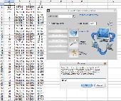
The Eye4Software Coordinate Calculator is an easy to use tool to perform map or Gps coordinate conversions. The software can be used to transform a single coordinate or a batch of Coordinates read from a comma separated, database or ESRI shapefiles. The software is shipped with a MS Access database file, containing more then 3500 ellipsoid, map datum and map grid definitions...
Category: Business & Finance / Calculators
Publisher: Eye4Software B.V., License: Shareware, Price: USD $49.00, EUR39, File Size: 3.2 MB
Platform: Windows

TRANSDATpro can prove a helpful tool for professionals, providing them with the possibility to perform coordinate transformations fast and easy by use of the coordinate reference systems of their choice. TRANSDATpro performs Coordinate Transformations fast and with high accuracy. The coordinate conversion software supports worldwide thousands of Coordinate Systems, geodetic Reference Systems...
Category: Home & Education / Science
Publisher: Killet GeoSoftware Ing.-GbR, License: Shareware, Price: USD $270.00, EUR240, File Size: 5.3 MB
Platform: Windows
The Gps Controller software is a free program designed to allow you to configure a range of Gps receivers. There are versions that run on Windows desktop computers, or Windows Mobile devices.
Before downloading the software, it recommend downloading and reading the documentation to confirm which version you need.
Category: Home & Education / Miscellaneous
Publisher: Trimble Navigation, License: Freeware, Price: USD $0.00, File Size: 30.9 MB
Platform: Windows