Free Downloads: Gps Satellite Tool
GPS Tuner was first launched in 2003.
Gps Tuner was first launched in 2003. Success followed introduction shortly. Over the years it became a best-selling favourite Gps software among off-roaders as a reliable, versatile feature-packed application suiting the needs of outdoor enthusiasts and professional off-road users alike. After five years of continuous development of previous Gps Tuner versions Gps...
Category: Web Authoring / Web Design Utilities
Publisher: GPS Tuner Ltd., License: Freeware, Price: USD $0.00, File Size: 4.5 MB
Platform: Windows

Gps Clock Software is a freeware utility that runs on any Windows NT/2000/XP/2003 workstation or server. The software polls time from a standard NMEA Gps time receiver connected to the host PC's serial port and optionally allows time to be synchronised on the host PC. The Gps clock utility polls GPRMC messages from a standard NMEA Gps time receiver. Information...
Category: Utilities
Publisher: ntp time server, License: Freeware, Price: USD $0.00, File Size: 1.9 MB
Platform: Windows
The OSTN02 extension for ArcPad is a FREE Tool that automatically transforms Gps data and aligns it with Ordnance Survey (OS) background map. This easy-to-use extension removes the need to manually post-process Gps data by providing’ on the fly’ transformation of WGS84 latitude and longitude into OSTN02 corrected British National Grid coordinate. Data capture...
Category: Home & Education / Miscellaneous
Publisher: ESRI (UK) Ltd, License: Freeware, Price: USD $0.00, File Size: 8.0 MB
Platform: Windows
Satellite earth is a software for viewing satellite and aerial imagery of the Earth.
Satellite earth is a software for viewing Satellite and aerial imagery of the Earth.Satellite Earth allows you to enjoy virtual travel around the world, look up local information and plan trips, exploring multimedia content and share information about your trips.Explore towns, cities and terrain relief shown in three-dimensional images of high resolution associated with...
Category: Home & Education / Science
Publisher: www.satelliteview-of-my-house.com, License: Freeware, Price: USD $0.00, File Size: 584.0 KB
Platform: Windows
Are you looking for a Gps tracking system or a Gps tracker but haven't found the one that is ideal for you? Then, look no further as our site has the best deals and information about the kind of Gps tracker you should buy.
Category: Security & Privacy / Other
Publisher: Top GPS Tracking Srl., License: Freeware, Price: USD $0.00, File Size: 722.0 KB
Platform: Windows
MapToaster Topo New Zealand is New Zealand's only topographical mapping suite, with options for your computer and Garmin Gps, including:
- all the rich detail of the LINZ topo maps - seamless across NZ. Now includes Topo50 and Topo250 map series.
- 1:50,000 though 1:2 million scale maps on your PC and 1:50,000 on your Gps
- integrated aerial and...
Category: Home & Education / Miscellaneous
Publisher: Integrated Mapping Ltd, License: Shareware, Price: USD $0.00, File Size: 38.5 MB
Platform: Windows
Gps Software for Garmin. Download waypoints, routes and tracks from Garmin Gps. Upload waypoints, routes and tracks to Garmin Gps. Excel and Text files supported! This software is very easy to use!
Category: Utilities / System Utilities
Publisher: Oy Frontbase Ltd, License: Shareware, Price: USD $29.95, File Size: 1.4 MB
Platform: Windows
 Shareware
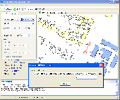
The Gps Generator PRO application is designed for providing assitance in developing, testing and debugging programs and equipment working with the NMEA-0183 protocol. This application can also be used for learning and testing navigation applications and equipment before purchasing. This virtual Gps receiver can work without visible Gps satellites, thus it's much more...
Category: Software Development / Help File Utilities
Publisher: Avangardo, License: Shareware, Price: USD $39.99, File Size: 800.5 KB
Platform: Windows
Ideal for business or families.
Ideal for business or families. Revolutionary GSM mobile phone tracking technology now allows registered users to locate a mobile and then displays the
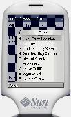
GSM mobile phone tracking system via the Gps-TRACK Satellite network. Based on repeater triangulation, the system tracks mobile phones using Gps Java ME. Find a mobile - Worried where your children, car, items are?...
Category: Internet / Communications
Publisher: 8Mail, License: Freeware, Price: USD $0.00, File Size: 13.0 KB
Platform: Windows
Portable GPS Navigation toolbar for Internet Explorer.
Portable Gps Navigation toolbar for Internet Explorer. Find portable Gps units for your car, truck or minvan from top name brands including Tom Tom, Magellan and Garmin. Discover the world of eBay and shop for portable Gps navigation systems directly from your browser toolbar.
Category: Internet / Browsers
Publisher: Portable GPS Navigation System, License: Freeware, Price: USD $0.00, File Size: 1.1 MB
Platform: Windows
Live Satellite Maps or Google maps is a web server mapping applications.
Live Satellite Maps or Google maps is a web server mapping applications.Provides scrolling map images and Satellite photos around the earth and even the route between different places.Since 6 October 2005, live Satellite Maps is part of local Google.Google live Satellite Map provides the ability to zoom in or zoom out to show the map.The user can control the map with...
Category: Home & Education / Science
Publisher: www.satelliteview-of-my-house.com, License: Freeware, Price: USD $0.00, File Size: 643.0 KB
Platform: Windows
Google Satellite SuperGet is a cute Tool that help you to get small tile Satellite images from google maps. All downloaded small images are saved on the disk. You can view downloaded maps by offline,you can export them into a big images or tile images. You can easily get the longitude and latitude of each exported images.
Category: Home & Education / Miscellaneous
Publisher: Arceyes, License: Shareware, Price: USD $0.00, File Size: 3.4 MB
Platform: Windows
Develop precise, efficient, and reliable location-based services with this multithreaded framework for desktop and mobile devices, including PocketPC, Tablet PC and now Smartphone! Over fifty classes in one lightweight assembly gives you unparalleled features while saving you hundreds of dollars in development and testing.
Gps.NET is loaded with features, including:
NEW:...
Category: Software Development / Components & Libraries
Publisher: StormSource Software, LLC, License: Commercial, Price: USD $98.00, File Size: 4.6 MB
Platform: Windows
CamIQ Satellite - digital recording and reliable image analysis.
CamIQ Satellite - digital recording and reliable image analysis.
CamIQ Satellite is based on a client-server-architecture which guarantees robustness and security as a basis. It can be extended flexible with modules just as the application requires.Comprehensive producer support for network based and analogue image sources (megapixelcameras, networkcameras, encoder and...
Category: Multimedia & Design / Multimedia App's
Publisher: rosemann software GmbH, License: Demo, Price: USD $0.00, File Size: 112.3 MB
Platform: Windows
Shareware
Gps SDK to add Gps and coordinate conversion functionality to your software and scripts). All NMEA0183 protocol versions are supported and can be filtered by NMEA sentence type and talker ID. Garmin USB PVT support. Information on Gps status can also be retrieved: Gps fix quality, satellites used in fix, satellites in view, Satellite azimuth, elevation and...
Category: Software Development
Publisher: Eye4Software B.V., License: Shareware, Price: USD $99.00, EUR79, File Size: 2.3 MB
Platform: Windows

Dishnetwork Deals Dish Satellite TV.
Dishnetwork Deals Dish Satellite TV. Dish Network Discounts. Dish Network TV Deals! Dish Network Television Deals and Free Offers! DISH Network installation and service nationwide. Satellite TV systems from Profressional Dealers. Free Dishnet receivers and DVR systems. Satelite Television, DISH, Digital TV, Broadband Internet, HD and DirectTV free satlite deals available. Order...
Category: Internet / Browsers
Publisher: Dishnetwork Deals, License: Freeware, Price: USD $0.00, File Size: 1.5 MB
Platform: Windows
Shareware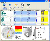
SatHunter is a program for calculating the orientation of a Satellite antenna. SatHunter contains all the necessary information for adjusting the Satellite antenna to the selected Satellite. The adjustment is made with the help of available tools (a compass or a protractor, a plumb, a tape measure) and requires neither expensive equipment nor deep knowledge about...
Category: Home & Education / Astrology & Numerology
Publisher: Protectedsoft Ltd., License: Shareware, Price: USD $29.95, File Size: 5.4 MB
Platform: Windows
Can you imagine how large an Satellite image is, which has dimensions of 86400 pixels wide and 43200 pixels high?This is a simple article which describes the Worlds Largest Satellite Images.See the largest Satellite images using a free software which is included inside.This free software will enables you to see Satellite images of the entire earth for free.
Category: Home & Education / Miscellaneous
Publisher: www.satelliteimage-of-my-house.com, License: Freeware, Price: USD $0.00, File Size: 590.0 KB
Platform: Windows
RouteBuddy is the only modern, advanced digital map application for Windows and Mac OS X.
RouteBuddy is the only modern, advanced digital map application for Windows and Mac OS X. It doesn't matter on which platform you wish to use the application as it sports a universal toolbar and comparable features throughout.
- High resolution Road, Topo and Satellite maps can be viewed in the same application using our state-of-the-art animated layer technology.
...
Category: Home & Education / Miscellaneous
Publisher: RouteBuddy Ltd, License: Shareware, Price: USD $59.99, File Size: 121.5 MB
Platform: Windows
Gps Tracker Data Logger acts as the server and allows you to collect data from an unlimited number of various Gps trackers simultaneously. The obtained data is processed, uniformed and written to a log file or a database. Also, the program has a set of interfaces so other applications can get data in real time.
Gps Tracker Data Logger can convert data into other...
Category: Internet / Misc. Servers
Publisher: AGG Software, License: Shareware, Price: USD $80.83, File Size: 11.8 MB
Platform: Windows
Orbitron 3.71is a Satellite tracking system for radio amateur and observing purposes.
The program can be also used by weather professionals, Satellite communication users, astronomers, UFO hobbyist and astrologers.
The program shows the positions of satellites at any moment (in real or simulated time).
Orbitron 3.71 can be installed in 35...
Category: Internet / Communications
Publisher: Sebastian Stoff, License: Freeware, Price: USD $0.00, File Size: 2.0 MB
Platform: Windows
Freeware
With this Tool you can add Gps coordinates to vCards - elektronic business cards - that you have previously exported from e. g. Microsoft Outlook. Therefore the Tool uses the address data contained within the vCards and adds the exact Gps position on that basis to the vCard. This way you can use these vCards for example in compatible car navigation systems....
Category: Home & Education / Home Inventory
Publisher: AB-Tools.com, License: Freeware, Price: USD $0.00, File Size: 1.9 MB
Platform: Windows
Tuner4PC allows configuring and establishing internet connection via satellite.
Tuner4PC allows configuring and establishing internet connection via Satellite. Once you have specified all the necessary parameters in the application, Tuner4PC will automatically configure a VPN, OpenVPN, Slonax, Globax, or Sprint link to your provider, depending on your choice.
Main Features:
- Automatic configuration of Satellite Internet connection...
Category: Utilities / Misc. Utilities
Publisher: Skysoftware, License: Shareware, Price: USD $39.99, File Size: 9.6 MB
Platform: Windows
The Gps Detector software is used to update the Gps detector's database , updating maps , routes and camera locations . The device itself is based on pre-installed Gps coordinates, the device can indicate various road hazards like: Fixed cameras, Red light speed cameras and bus lane cameras, Usual speed measurement places and dangerous zones.
Category: Business & Finance / Business Finance
Publisher: Euro Noliker Kft., License: Freeware, Price: USD $0.00, File Size: 5.5 MB
Platform: Windows
View amazing satellite images of earth with the free version of google earth software.
View amazing Satellite images of earth with the free version of google earth software.Google earth is a totally free software which enables you zoom in from Satellite,view,rotate or tilt just like a camera of the entire earth inside your pc.It works just point and click on any part of earth or by typing addrees name of city or country and google earth will down from space to the...
Category: Home & Education / Miscellaneous
Publisher: www.satelliteimage-of-my-house.com, License: Freeware, Price: USD $0.00, File Size: 798.0 KB
Platform: Windows