Free Downloads: Imei Gps Tracking Software
NovaGPS provides manual or automatic setting of time and location from consumer-grade (or better) Gps receivers. NovaGPS is not the same as Dr. Tom Clark's Totally Accurate Clock because NovaGPS does not require a specialized Gps receiver or modification to other Gps receivers.
Instead, NovaGPS offers accuracy to better than 0.5 seconds using off-the-shelf...
Category: Home & Education / Miscellaneous
Publisher: Northern Lights Software Associates, License: Shareware, Price: USD $19.95, File Size: 1.0 MB
Platform: Windows
The Gps Controller Software is a free program designed to allow you to configure a range of Gps receivers. There are versions that run on Windows desktop computers, or Windows Mobile devices.
Before downloading the Software, it recommend downloading and reading the documentation to confirm which version you need.
Category: Home & Education / Miscellaneous
Publisher: Trimble Navigation, License: Freeware, Price: USD $0.00, File Size: 30.9 MB
Platform: Windows
 Freeware
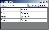
The International Mobile Equipment Identity or Imei is a number unique to every mobile phone, as well as some satellite phones. It is usually found printed inside the battery compartment of the phone. It can also be displayed on the screen of the phone by entering *#06# into the keypad. CheckIMEI Software show information about manufacturer, model type, and country of approval of...
Category: Internet / Internet Phone and Teleconferencing
Publisher: zalex, License: Freeware, Price: USD $0.00, File Size: 390.2 KB
Platform: Windows
The leading GPS interface tool for Windows!
The leading Gps interface tool for Windows! Gps answers the significant world demand for accurate, viable and cost effective positioning systems. The Geographic Tracker delivers all of the power and utility of Gps to the Windows environment by allowing you to link a Gps receiver to other Microsoft Windows applications through standard Windows DDE messaging.
Category: Home & Education / Miscellaneous
Publisher: Bluemarble Geographics, License: Shareware, Price: USD $0.00, File Size: 0
Platform: Windows
The Gps Detector Software is used to update the Gps detector's database , updating maps , routes and camera locations . The device itself is based on pre-installed Gps coordinates, the device can indicate various road hazards like: Fixed cameras, Red light speed cameras and bus lane cameras, Usual speed measurement places and dangerous zones.
Category: Business & Finance / Business Finance
Publisher: Euro Noliker Kft., License: Freeware, Price: USD $0.00, File Size: 5.5 MB
Platform: Windows
V-Clinic GPS lets you track your training routes and upload the data back to your V-Clinic account.
V-Clinic Gps lets you track your training routes and upload the data back to your V-Clinic account. Then use V-Clinic to share your route with your training buddies. V-Clinic Gps is ideal for cyclists, joggers and outdoor enthusiasts. V-Clinic Gps runs on Gps & Java enabled phones. Use V-Clinic Gps on your own or get professional fitness analysis and...
Category: Home & Education / Health & Nutrition
Publisher: V-CLINIC MOBILE CIRCLES, License: Freeware, Price: USD $0.00, File Size: 235.0 KB
Platform: Unknown
CyCop monitors Heritage security guards at all times via GPS tracking.
CyCop monitors Heritage security guards at all times via Gps Tracking.
Some features of the Dashboard include:
- View and search Daily Activity Reports
- View Site Coverage Maps
- View coverage alerts status in real-time
- Site Performance Metrics
- Client feedback form
- Search archived reports and security coverage information
Category: Business & Finance / MS Office Addons
Publisher: Heritage Security Services, License: Freeware, Price: USD $0.00, File Size: 4.2 MB
Platform: Windows
OziExplorer is a flamboyant Gps Mapping Software that runs on the PC and works with varieties of Gps receivers such as Garmin, Lowrance, Magellan, Eagle, Brunton, Silva and MLR for the uploading or downloading the waypoints, routes and tracks and most brands of Gps receivers for real time Tracking of Gps position.
Using this...
Category: Internet / Communications
Publisher: Des Newman, License: Shareware, Price: USD $95.00, File Size: 6.8 MB
Platform: Windows
Portable GPS Navigation toolbar for Internet Explorer.
Portable Gps Navigation toolbar for Internet Explorer. Find portable Gps units for your car, truck or minvan from top name brands including Tom Tom, Magellan and Garmin. Discover the world of eBay and shop for portable Gps navigation systems directly from your browser toolbar.
Category: Internet / Browsers
Publisher: Portable GPS Navigation System, License: Freeware, Price: USD $0.00, File Size: 1.1 MB
Platform: Windows
SmartComGPS is a Gps mapping/Tracking/navigation Software for Symbian smartphones. It is one of most advanced Gps mapping Software on the market. SmartComGPS designed for the all Symbian phones. It is compatible with external BT Gps receivers, and internal aGPS receiver of Motorola A920/925/1000. SmartComGPS can run without Gps receiver, as...
Category: Multimedia & Design
Publisher: SmartCom Ltd GPS Mobile Solutions, License: Shareware, Price: USD $29.95, File Size: 291.1 KB
Platform: Unknown
SmartComGPS is a Gps mapping/Tracking/navigation Software for Symbian smartphones. It is one of most advanced Gps mapping Software on the market. SmartComGPS designed for the all Symbian phones. It is compatible with external BT Gps receivers, and internal aGPS receiver of Motorola A920/925/1000. SmartComGPS can run without Gps receiver, as...
Category: Multimedia & Design
Publisher: SmartCom Ltd GPS Mobile Solutions, License: Shareware, Price: USD $29.95, File Size: 284.7 KB
Platform: Unknown
SmartComGPS is a Gps mapping/Tracking/navigation Software for Symbian smartphones. It is one of most advanced Gps mapping Software on the market. SmartComGPS designed for the all Symbian phones. It is compatible with external BT Gps receivers, and internal aGPS receiver of Motorola A920/925/1000. SmartComGPS can run without Gps receiver, as...
Category: Multimedia & Design
Publisher: SmartCom Ltd GPS Mobile Solutions, License: Shareware, Price: USD $29.95, File Size: 299.4 KB
Platform: Unknown
DNRGarmin is a smart tool used to directly transfer data between Garmin Gps handheld receivers and various GIS Software packages.
DNRGarmin was built to provide users the ability to directly transfer data between Garmin Gps handheld receivers and various GIS Software packages. Using DNRGarmin a user can use point features (graphics or shapefile) and...
Category: Utilities / Misc. Utilities
Publisher: GIS Section, Minnesota Department of Natural Resources, License: Freeware, Price: USD $0.00, File Size: 11.3 MB
Platform: Windows

Gps/J is a console for all Bluetooth-enabled Gps receivers (now with 20000 European towns and cities!), a mobile navigation tool for cellular phone owners and the most affordable and convenient way to use location services.
It is a J2ME application for JSR82-compliant devices, which means "devices with a programmable Bluetooth interface".
Saying...
Category: Home & Education / Miscellaneous
Publisher: GPS/J Project, License: Demo, Price: USD $0.00, File Size: 281.0 KB
Platform: Windows
Shareware
Gps Mapping Software for Windows, Loading topographic maps, manage Gps devices and more. The Software can be used with various map formats including: GeoTiff, BSB Nautical Charts, AutoCad DXF files, ESRI Shapefiles. Using calibration you can also use scanned or downloaded JPG, BMP, GIF, PNG and TIF maps. The Software can be used for survey, research, track and...
Category: Home & Education / Science
Publisher: Eye4Software B.V., License: Shareware, Price: USD $75.04, EUR49, File Size: 6.7 MB
Platform: Windows

Overview Gps Simulator is Software that generates a virtual Gps data Used to develop and simulation of Gps applications -Save testing and development time -No location restriction or work everywhere -No Gps device needed Feature Easy routing Selectable map(7EA Map) Support speed control Support 10EA NMEA protocol messages(GGA, GNS, GLL, RMC,...
Category: Desktop Enhancements / Shell & Desktop Managers
Publisher: NMEAsoft, License: Demo, Price: USD $150.00, File Size: 3.3 MB
Platform: Windows
ThinkVantage Gps (Global Positioning System) receives signals from the Gps satellites and determines the location of your ThinkPad. This program is easy to install and easy to manipulate.
This package installs the Software (Gps driver) to enable the following devices:
- Ericsson F3507g
- Ericsson F3607gw
- Ericsson F5521gw
...
Category: Utilities / System Utilities
Publisher: Lenovo, License: Freeware, Price: USD $0.00, File Size: 20.6 MB
Platform: Windows
CDR Data Analysis Software is best call data analysis Software which is track call information from your CDR file extract your data according to max call, max durations, max cell tower information & grouping caller Imei number - which is showing how much cell number you're using to your Imei Numbers. CDR Data Analysis Software Feature---- => Single Number...
Category: Security & Privacy / Covert Surveillance
Publisher: CDR Data Analysis Software, License: Shareware, Price: USD $700.00, File Size: 5.1 MB
Platform: Windows
KANINE Software is the only K-9 records Software that offers Gps Tracking capabilities and in program functionality to download K-9 tracks directly to maps that can easily be attached to usage and training records.
KANINE records have been called ‘bullet proof’ by Prosecuting Attorneys. KANINE’s printed reports can easily be printed or...
Category: Business & Finance / Business Finance
Publisher: Code Blue Designs, License: Shareware, Price: USD $150.00, File Size: 21.1 MB
Platform: Windows
The fast track to GPS success.
The fast track to Gps success. The Linx MDEV-Gps-SR contains everything needed to rapidly evaluate the SR Series Gps modules and implement them in record time. This all-inclusive Master Development System features a pre-assembled development board with an on-board OLED display for standalone testing. The system can also be attached to a PC via USB and operated using the...
Category: Software Development / Misc. Programming
Publisher: Linx Technologies, Inc., License: Freeware, Price: USD $0.00, File Size: 98.5 MB
Platform: Windows

Improve your golf game with a handheld Gps that gives distance to pin, club suggestions, locations of hazards and much more. Wherever in the world you play golf, the sureshotgps will allow you to obtain distances from tee to green. Experience the difference with better club selection, speedier play and statistical information per round of golf. The sureshotgps relies on Gps...
Category: Home & Education
Publisher: Absolute Software Pty Ltd, License: Shareware, Price: USD $399.00, File Size: 3.8 MB
Platform: Windows
With our locr PC Software "locr Gps Photo for Windows" you can manage to automatically geotag numerous photos simultaneously. You just require a digital camera, a Gps data logger and the application "locr Gps Photo for Windows".
There are two ways to geotag your photos: The photos can be tagged manually or automatically. For automatic...
Category: Multimedia & Design / Multimedia App's
Publisher: locr, License: Freeware, Price: USD $0.00, File Size: 490.8 KB
Platform: Windows
GPS-CCD:is a novel computational program for the
Prediction of Calpain Cleavage Sites.
Gps-CCD:is a novel computational program for the
Prediction of Calpain Cleavage Sites.
The online service and local packages of Gps-CCD 1.0 were
implemented in JAVA/. For the online service, we tested the Gps-CCD1.0 on a variety of internet browsers, including Internet Explorer 6.0, Netscape Browser 8.1.3 and Firefox 2 under the Windows XPOperating System...
Category: Web Authoring / JavaScript
Publisher: The CUCKOO Workgroup, License: Freeware, Price: USD $0.00, File Size: 19.2 MB
Platform: Windows
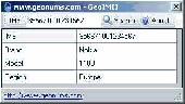
The International Mobile Equipment Identity or Imei is a number unique to every mobile phone, as well as some satellite phones. It is usually found printed inside the battery compartment of the phone. It can also be displayed on the screen of the phone by entering *#06# into the keypad. GeoIMEI Software show information about manufacturer, model type, and country of approval of a...
Category: Internet / News Applications
Publisher: GeoNums, License: Freeware, Price: USD $0.00, File Size: 896.0 KB
Platform: Windows