Free Downloads: Latitude Longitude Jpg
MyGPS is a Freeware software for the creation and the management of Longitude and Latitude calibrated maps.
The software can define points of interest obtaining their coordinates (waypoints), can create routes (routepoints), can visualize track paths (trackpoints).
Using a serial link, points routes and tracks can be shared with "eTrex" and "Geko"...
Category: Home & Education / Miscellaneous
Publisher: GPSInfo, License: Freeware, Price: USD $0.00, File Size: 2.3 MB
Platform: Windows
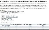
One stop solution for Latitude Longitude Database, Cities Database, Zipcode Database and County Database. Our product line covers a basic edition world cities database that includes major cities of the world which is perfectly suitable to capture country and city information of a visitor registering on your website. In addition, we have a detailed county/cities database called...
Category: Web Authoring / Web Design Utilities
Publisher: Best World Cities Database Ever, License: Freeware, Price: USD $0.00, File Size: 51.4 KB
Platform: Windows, Mac,
The GPS map will help you give you with turn by turn directions to your destination using a POI, city point and/or Longitude and Latitude.It has the ability to preplan driving destinations before getting into your car. Compatible with ALL Garmin GPS units. Don't pay more than US$10 per day when you already own a Garmin, this is the most comprehensive GPS map available at such...
Category: Home & Education / Miscellaneous
Publisher: GPSTravelMaps.com, License: Shareware, Price: USD $0.00, File Size: 0
Platform: Windows
IP2Location IP-COUNTRY-REGION-CITY-Latitude-Longitude-ZIPCODE-ISP-DOMAIN is commericial lookup database that 1. Provide Location Aware Content (language, currency, etc.)
2. Redirect based on country;
3. Digital rights management;
4. Prevent password sharing and abuse of service;
5. Reduce credit card fraud;
6. Web log stats and analysis;
7. Auto-selection...
Category: Internet / Misc. Plugins
Publisher: IP2Location.com, License: Data Only, Price: USD $799.00, File Size: 200.0 KB
Platform: Windows, Linux, Mac, Palm
You can enter your City/State OR Zipcode and it outputs a lot of useful information like Azimuth, Elevation, Latitude, Longitude, and Magnetic Deviation. It also has a text database for the satellites that makes it easy to modify satellite names and easy to add or delete satellites.
Category: Home & Education / Miscellaneous
Publisher: NeuroSoft, License: Freeware, Price: USD $0.00, File Size: 1.6 MB
Platform: Windows

IP2Location IP-COUNTRY-REGION-CITY-Latitude-Longitude-ZIPCODE-TIMEZONE-ISP-DOMAIN-NETSPEED-AREACODE is commercial lookup database that translates IP address to country, region, city, Latitude, Longitude, ZIP code, time zone, ISP, domain name, connection speed, IDD code and area code. Developers use this database for: 1. Provide Location Aware Content...
Category: Audio / MIDI Applications
Publisher: IP2Location.com, License: Data Only, Price: USD $1399.00, File Size: 195.3 KB
Platform: Windows, Linux, Palm, Mac, Unix, MS-DOS, AS/400, OS/2, OpenVMS
GeoDataSource Cities Database Gold Edition contains 2.9+ million entries with city names in original language and English, feature type classifications, country names in FIPS and ISO, regions, sub-regions, state or First-Order Administrative Division, county or Second-Order Administrative Division, Longitude and Latitude in degree and decimal, Univeral Transverse Mercator...
Category: Security & Privacy / Other
Publisher: GeoDataSource.com, License: Data Only, Price: USD $1049.95, File Size: 160.3 KB
Platform: Windows, Mac, Linux, Palm,
Windows DLL to find the distance in miles between 2 latitude/longitude points, specified in degrees.
Category: Home & Education / Miscellaneous
Publisher: kjlsoftware.com, License: Freeware, Price: USD $0.00, File Size: 36.0 KB
Platform: Windows, Mac, 2K
Rocanda Land Tracker software will allow you to convert any LSD location in Alberta, British Columbia, Saskatchewan or Manitoba into a corresponding Latitude/Longitude coordinate. which you can then input into mapping software such as Garmin's Mapsource products, or OziExplorer.
Category: Business & Finance / MS Office Addons
Publisher: Rocanda, License: Shareware, Price: USD $179.00, File Size: 8.6 MB
Platform: Windows
WGS-84 Calculator is used to calculate geodetic distance and azimuth between two points (Latitude and Longitude). In addition, it can calculate a new point from origin using the given azimuth and distance.
Lat/long values can be inserted using three different formats; DD:MM:SS.ssss, DD:MM.mmmmmm or DD.dddddddd.
Calculations are based on WGS-84 (World...
Category: Home & Education / Mathematics
Publisher: MR Soft Tmi, License: Freeware, Price: USD $0.00, File Size: 502.0 KB
Platform: Windows
IP2Location IP-COUNTRY-REGION-CITY-Latitude-Longitude-ZIPCODE-TIMEZONE-ISP-DOMAIN-NETSPEED-AREACODE-WEATHER is commercial lookup database that translates IP address to country, region, city, Latitude, Longitude, ZIP code, time zone, ISP, domain name, connection speed, IDD code, area code, weather station code and station name. . Developers use this database for:...
Category: Audio / MIDI Applications
Publisher: IP2Location.com, License: Data Only, Price: USD $1399.00, File Size: 195.3 KB
Platform: Windows, Linux, Palm, Mac, Unix, MS-DOS, AS/400, OS/2, OpenVMS
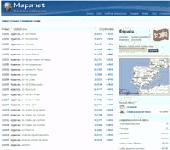
Zip Codes databases from most of the countries with all regions, cities, areas, districts, streets, block numbers, Latitude and Longitude, area code, time zone and more. Tools and formulas to calcualte distance between postal codes and or coordinates. Format UTF-8 in TXT file comma separated for easy upload to any database system.
Category: Web Authoring / Web Design Utilities
Publisher: Mapanet, S de RL, License: Data Only, Price: USD $109.00, File Size: 120.0 KB
Platform: Windows
This software was developed because from time to time, we found it necessary to convert GPS meter readings from fractional Latitude and Longitude to degrees, minutes and seconds (DMS). It only does this one thing but it does it very well. Version 2.0, just released 5/23/2007, now converts both directions (DMS to fractional and fractional to DMS). It also has a new, modern look.
Category: Home & Education / Miscellaneous
Publisher: Rad Pro Calculator, License: Freeware, Price: USD $0.00, File Size: 33.1 MB
Platform: Windows
 Data Only
IP2Location IP-COUNTRY-REGION-CITY-Latitude-Longitude-ZIPCODE-TIMEZONE-ISP-DOMAIN-NETSPEED-AREACODE-WEATHER-MOBILE-ELEVATION-USAGETYPE is commercial IP geolocation database that translates IP address to country, region, city, Latitude, Longitude, zip code, time zone, ISP name, domain name, net speed, area code, IDD code, weather, mobile, elevation and usage type....
Category: Internet / Tools & Utilities
Publisher: IP2Location.com, License: Data Only, Price: USD $3399.00, File Size: 94.5 MB
Platform: Windows
This GPS map will give you turn by turn directions to your destination using a POI (point of interest), city point and/or Latitude and Longitude with the ability to preplan driving destinations before getting into your car.
This is the most comprehensive GPS map available at such an affordable price!
Category: Home & Education / Miscellaneous
Publisher: GPSTravelMaps.com, License: Shareware, Price: USD $0.00, File Size: 0
Platform: Windows
IP2Location Java component that translates IP address to country, city, region, Latitude, Longitude, ZIP code, ISP and domain name. No external lookup or connection required. Developers use this component for projects related to:
1. Display native language and currency;
2. Redirect based on country;
3. Digital rights management;
4. Prevent password sharing and...
Category: Web Authoring / JavaScript
Publisher: IP2Location.com, License: Shareware, Price: USD $99.00, File Size: 523.0 KB
Platform: Windows
Shareware
Amethyst ShadowFX is a sun and shadow analysis program for architects, designers and town planners. With the program, you can generate shadow profiles cast by buildings and other objects for any Latitude, Longitude and time of year. Version 3 of the program represents a significant upgrade. With the program, you can: Interactively build a 3D model that allows you to examine...
Category: Multimedia & Design / Graphics Viewers
Publisher: CA Desgn, License: Shareware, Price: USD $95.00, File Size: 10.5 MB
Platform: Windows
LocationTool appears to be a very interesting application.
LocationTool appears to be a very interesting application. It allows one to know Latitude, Longitude and time zone of towns or cities all around the world.
It has a very simple interface that consists of only one window. This window includes search fields, a list with search results and the world map. The application allows to search by city name or by its position on...
Category: Home & Education / Miscellaneous
Publisher: Square One research, License: Freeware, Price: USD $0.00, File Size: 0
Platform: Windows
Geozip calculates distance between US (optionally Canadian) zip codes or geographical coordinates, Latitude and Longitude. It does take into account the curvature of the earth for calculating. You can choose miles, kilometers or nautical miles output. Customixation is available if you need more specific applications using the Geozip geographical distance calculations.
Category: Business & Finance
Publisher: Island Limited, License: Shareware, Price: USD $49.00, File Size: 2.3 MB
Platform: Windows
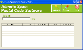
The Software includes postal code, city name, colony name, area abbreviation, Latitude and Longitude, time zone and area code in Almeria. Enter 2 area name and get the distance between them. Easy to download reports in excel.
Category: Business & Finance
Publisher: Almeria Properties, License: Freeware, Price: USD $0.00, File Size: 3.3 MB
Platform: Windows
This application will extract data regarding Business Name, Business Address, City, State, Zip-code, Phone Number, Fax, Web URL, Email Address, Business Details, Latitude & Longitude from Yellow Pages.Com & Super Pages.Com in a clean and readable CSV format.
Category: Business & Finance / Database Management
Publisher: Aruhat Technologies Pvt. Ltd, License: Demo, Price: USD $125.00, File Size: 1.2 MB
Platform: Windows
IP2Location Desktop translates IP address to country, city, region, Latitude, Longitude, ZIP code, ISP and domain name using XML Web Service. Users can perform 90 queries per month using Free account. Please visit http://www.fraudlabs.com for more information.
Category: Internet
Publisher: FraudLabs.com, License: Freeware, Price: USD $0.00, File Size: 777.7 KB
Platform: Windows
Shareware
You can also view the response times, ISP, latitude/longitude, packet loss and more. . .
Category: Internet / Monitoring
Publisher: 3DSNMP, License: Shareware, Price: USD $49.95, File Size: 58.4 MB
Platform: Windows
Zip Code Genie looks up and fills in address data (city name, state name, area code, county, FIPS number, Latitude, Longitude, etc.) automatically for you, based on the zip codes that you type. Works with your existing word processing documents, spreadsheets, and database forms. Compatible with office suites from Microsoft, Corel, Lotus, Sun, and many other commercial and custom...
Category: Business & Finance / Applications
Publisher: Spud City Software Co., License: Shareware, Price: USD $49.95, File Size: 2.1 MB
Platform: Windows
The GeoDataSource .NET Control works with Microsoft Access, SQL Server and mySQL to query the complete GeoDataSource World Cities Database (Basic, Premium and Gold Edition). You can use the software object to query database by city and also calculate the distance between two cities or two Latitude and Longitude sets. This component will help developers to speed up the integration...
Category: Web Authoring / Site Management
Publisher: GeoDataSource.com, License: Shareware, Price: USD $99.95, File Size: 1.2 MB
Platform: Windows