Free Downloads: Links And Maps
From the Sacre Coeur to the Arc de Triomphe, your holiday to Paris starts from the moment you open your guide, plus you get Paris Maps and transport Maps.
Discover the best cafe terraces, unmissable museums and galleries, loveliest parks and gardens, best areas to shop or browse, unforgettable shows and live music venues, most fun places for children, and best restaurants to...
Category: Internet / Communications
Publisher: Mobile Systems, License: Shareware, Price: USD $9.80, File Size: 0
Platform: Windows
 Shareware
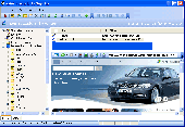
Links Organizer provides quick access to the most kinds of Links on your system - from Start menu and Desktop to Internet Links. Using Links Organizer, you can inspect, edit, exchange Links between categories. It also includes Links verification and ability to remove invalid Links and fix Links to moved Internet locations. You can schedule...
Category: Internet / Tools & Utilities
Publisher: MetaProducts Corporation, License: Shareware, Price: USD $25.00, File Size: 1.7 MB
Platform: Windows
When you are looking for a powerful tool to satisfy various needs regarding vectors, raster and satellite imagery, you will find ILWIS Academic an efficient application. The program comes with such useful features as points to create Maps, lines for segment Maps, closed area segments for polygon Maps, spatial operations for raster Maps and so on. Whilst using images...
Category: Home & Education / Miscellaneous
Publisher: ITC, License: Freeware, Price: USD $0.00, File Size: 19.4 MB
Platform: Unknown
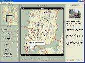
GDS Images and Document Maps is a unique document search utility.
GDS Images and Document Maps is a unique document search utility. GDS Images and Document Maps is a rather unique application that will enable you to store all your documents and images alongside other important files and folders right on your desktop so that you can use it straight from there, without the need to bother around with looking with looking for every single file...
Category: Utilities / Misc. Utilities
Publisher: toggle, License: Freeware, Price: USD $0.00, File Size: 558.8 KB
Platform: Windows
With links and additional information on important topics for geography lessons.
With Links and additional information on important topics for geography lessons. 3D-view of atlas (book) Maps on a virtual globe, high resolution physical map, political map, satellite images, land coverage and earth-at-night map. Create your own map legend, use the drawing tool, move and insert atlas symbols and much more.
Category: Multimedia & Design / Fonts
Publisher: Imagon GmbH, License: Freeware, Price: USD $0.00, File Size: 6.1 MB
Platform: Windows
MapCreator combines a cartography and a graphics programme.
MapCreator combines a cartography and a graphics programme. The software is designed to create Maps and animated Maps of the highest quality as often required for presentations. For example, this could be Maps needed for a travel presentation. But also in
Category: Multimedia & Design
Publisher: primap.com, License: Freeware, Price: USD $0.00, File Size: 103.3 MB
Platform: Windows, Vista
CacheMaps retreives a variety of maps for your caches from the Internet.
CacheMaps retreives a variety of Maps for your caches from the Internet.
CacheMaps uses the Geocaching loc- or gpx-files as input. Directely from the Geocaching site or as exported from GSAK.CacheMaps v4 has been designed to be used next to GSAK. A lot of the functionality that was available in previous versions of CacheMaps, is available in GSAK now in a much better form. What...
Category: Audio / Utilities & Plug-Ins
Publisher: BigBird Productions, License: Freeware, Price: USD $0.00, File Size: 153.2 KB
Platform: Windows
FRSLinkCheck is a software tool for validating all the Links on one or more web sites you maintain. It can verify the Links between files in your web site, as well as Links to other web sites on the Internet. FRSLinkCheck is intended for anyone who maintains web sites, either as a hobby or as part of your work responsibilities. So What's the Problem? Nearly all web...
Category: Internet
Publisher: Fourth Ray Software, License: Shareware, Price: USD $29.95, File Size: 2.4 MB
Platform: Windows
Search and extract links (URL or Email) from pages or files.
Search and extract Links (URL or Email) from pages or files. Main Features: - automatic Links search;- search in webpage, file or folder- load file or paste from clipboard- Find URL or Email Links option- full URL Links, domen or filename option- Links view option as: link, html code, bb code- Links sorting- remove http://- save Links in HTML or...
Category: Utilities / Network
Publisher: Altarsoft, License: Freeware, Price: USD $0.00, File Size: 316.0 KB
Platform: Windows
MAPC2MAPC is a program to manipulate digital Maps,it loads map images and calibrate them,loads calibrations in many different formats and Datums,view the calibrated map,crop and rescale Maps whilst preserving the calibration,reproject Maps to 'Plate Carre' (Equirectangular),rotate Maps to true North.
Category: Multimedia & Design / Digital Media Editors
Publisher: Thorn, License: Shareware, Price: USD $0.00, File Size: 1.6 MB
Platform: Windows
Create GPS enabled geo Maps directly on the background of aereal photos and road Maps from the internet. Import geodata from Google-Earth, OpenStreetMap, GPS tracks and GPS logger. Map editor , manually digitizing. Specifical graphical objects (borderlines, borderareas) to guarantee exact same borders of neighbour areas..Screen calibration for true to display on the screnn.
Category: Multimedia & Design / Digital Media Editors
Publisher: GPSur Dr. Erhard Regener, License: Shareware, Price: USD $65.00, File Size: 6.4 MB
Platform: Windows
Extract URL Links (Hyper Links) from HTML files.
Extract URL Links (Hyper Links) from HTML files. Also extracts JAVA Links. Full Single and Multi-extractions with all selections, directory, viewing, etc. on screen. Creates both Sorted Links files and a Java ?Site Search? using internal code.
Category: Internet / Misc. Servers
Publisher: alltodaysnews.com, License: Freeware, Price: USD $0.00, File Size: 122.0 KB
Platform: Windows, Mac, 9x, 2K
Terrain Tools - Create maps quickly and easily!
Terrain Tools - Create Maps quickly and easily!
Terrain Tools is the ideal tool for outdoor recreationists, real-estate professionals, farmers, ecologists, archaeologists and others who need to create basic Maps, calculate areas, lengths, bearings and distances.
Overlay GPS tracks on scanned images such as USGS or Canadian NTS topos. Import and export...
Category: Business & Finance / Applications
Publisher: Softree, License: Shareware, Price: USD $124.00, File Size: 15.0 MB
Platform: Windows
Shareware
Offline Map Maker is a tool that help you to get offline tile images from Google Maps, Openstreetmap, Yandex Maps, Yahoo Maps, Mapquest, Gaode map, Tencent Maps, Baidu Maps, Tianditu, Arcgis Online, OneMap, Whereis, mapy.cz, Mappy, Waze, Sentinel-2 map, Strava Gloabal Heatmap, Wikimapia, GoMap.Az, Longdo Map, Bhuvan, National Map Australia, New Zealand...
Category: Internet / Download Managers
Publisher: allmapsoft.com, License: Shareware, Price: USD $79.00, File Size: 31.1 MB
Platform: Windows
With MapAuthor you can create, print and save desktop Maps, using data that you obtain from commercial sources or perhaps your in-hous GIS department as shapefiles (shapefiles are a very common GIS exchange format.) You can also produce internet-based Maps based on Google Maps, for use on your web site.
MapAuthor allows you to link your own data to Maps, for...
Category: Internet / Misc. Plugins
Publisher: MapAuthor.com, License: Freeware, Price: USD $0.00, File Size: 6.3 MB
Platform: Windows
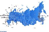
Dongsoft Interactive Russia Flash Maps for websites, interactive map applications, presentations, and more.
The innovation of this fully-clickable map will revolutionize your website navigation and provide visitors with a simple and seamless method of accessing information. Using the map as a central navigation tool, information can be accessed with greater speed, enhanced...
Category: Software Development / Help File Utilities
Publisher: clickable map, License: Freeware, Price: USD $0.00, File Size: 156.0 KB
Platform: Windows
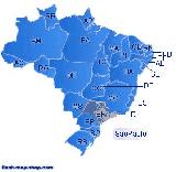
Dongsoft Interactive Brazil Flash Maps for websites, interactive map applications, presentations, and more.
The innovation of this fully-clickable map will revolutionize your website navigation and provide visitors with a simple and seamless method of accessing information. Using the map as a central navigation tool, information can be accessed with greater speed, enhanced...
Category: Software Development / Help File Utilities
Publisher: maps flash, License: Freeware, Price: USD $0.00, File Size: 156.0 KB
Platform: Windows
Download, View, and Print Maps with the MrSID Viewer.
Download, View, and Print Maps with the MrSID Viewer.
To download and view Maps offline you need a special viewer. Maps are stored in MrSID format. The MRSID Viewer is a freeware tool. This library provides access to the MrSID viewer developed by LizardTech.
NOTE:
LizardTech dropped the link for that stand-alone viewer download from...
Category: Multimedia & Design / Graphics Viewers
Publisher: Lizardtech, License: Freeware, Price: USD $0.00, File Size: 2.0 MB
Platform: Windows
All-in-1 Personal Information Manager is a personal organizer useful for managing any kind of personal information such as tasks, events, contacts, notes, file Links, Web Links and executable key scripts.
All information is contained in one or more password-protected Microsoft Access 2000 databases (however, you don't need to install Access 2000).
...
Category: Business & Finance / Business Finance
Publisher: Bruno Cancellieri, License: Shareware, Price: USD $15.00, File Size: 6.5 MB
Platform: Windows
The world's first dynamic travel guides. Schmap 2.0 opens a new world of flexibility for browsing, searching and customizing travel guide content (reviews, photos and Maps). Once installed, simply choose from Schmap's rapidly growing series of US, European and Canadian destination guides, each with zooming, panning Maps, useful Links, playable virtual tours, top...
Category: Home & Education
Publisher: Schmap, License: Freeware, Price: USD $0.00, File Size: 1.5 MB
Platform: Windows
Freeware
Free standalone software DataPult Desktop creates heat Maps from your data quickly and efficiently. Key features: Direct data import from MS Excel with one click. The ability to create animated Maps of data over several years. Interactive Maps and diagrams. 39 map colorings for making heat Maps. Intelligent identification of input...
Category: Business & Finance / MS Office Addons
Publisher: DataPult, License: Freeware, Price: USD $0.00, File Size: 21.0 MB
Platform: Windows
It Contains radius maps from modules 1-3 and runs from 1- 4.
It Contains radius Maps from modules 1-3 and runs from 1- 4. Creates random written exams to the same format as the PCO using WizAnn Radius Maps and automatically marks them. Drag and drop points onto the map and type in runs and compare with inbuilt runs. Perfect for Written test preparation.
Category: Multimedia & Design / Fonts
Publisher: WizAnn Publications Design, License: Shareware, Price: USD $0.00, File Size: 0
Platform: Windows
Shareware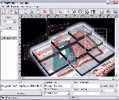
Create HTML Image Maps of any shape in just a few clicks! Map Designer automates the creation of HTML Image Maps, making it easy for designers and Web developers to specify hot-Links and clickable areas within images. Map Designer helps Web developers specify rectangular, round or arbitrary-shape areas in a what-you-see-is-what-you-get mode. Specifying an active region...
Category: Web Authoring / HTML Editors
Publisher: ForthTech Software, License: Shareware, Price: USD $23.00, File Size: 1.1 MB
Platform: Windows
Microsoft MapPoint software gives you the power to turn tabular data into informative Maps to communicate insights with instant impact. You can easily integrate Maps into your Office projects to show your business insights with clarity. Plus, get updated Maps of the US and Canada, with trip routing, turn-by-turn directions, and the ability to share routes with your GPS device.
Category: Business & Finance / MS Office Addons
Publisher: Microsoft, License: Shareware, Price: USD $0.00, File Size: 0
Platform: Windows
From Gothic St. Stephens Cathedral to the Imperial Palace - the 10 best of everything to see, buy, do, taste and avoid in Vienna, plus Maps and transport Maps.
Discover the best historic palaces and gardens, great walks and itineraries, most fun places for kids, venues for concerts and opera, liveliest beer halls, tastiest schnitzel and Viennese cakes, best hotels on every...
Category: Internet / Communications
Publisher: Mobile Systems, License: Shareware, Price: USD $9.80, File Size: 0
Platform: Windows