Free Downloads: Map Grid Conversion
QUIKGRID is a program which will read in a set of scattered data points (x, y, z) which represents a surface. The program will generate a Grid from this data and then display the surface as a contour Map, or as a coloured 3d Grid. The left mouse button ma
Category: Home & Education / Mathematics
Publisher: perspectiveedge.com, License: Freeware, Price: USD $0.00, File Size: 484.0 KB
Platform: Windows, Mac, 2K
The Software for Filling Out Any Forms (e.
The Software for Filling Out Any Forms (e.g. pre-printed forms, business forms, government forms, images of electronic forms in Word or PDF etc)
If you are searching for form filler software, you have found it --- FarFast Form Filler, the fastest form filler on the market.
Features:
- The preprinted form filler software program is able to display the form image in the top...
Category: Utilities / System Utilities
Publisher: HexaTech, License: Freeware, Price: USD $0.00, File Size: 2.3 MB
Platform: Windows
 Freeware
An interactive Flash USA Map with all the features you need for your web site or project. This is the ideal solution for dealer maps, real-estate listings, or visualizing state statistics. Nearly every aspect of the Map is customizable. However, unlike competing products, our Map is very simple to install and edit. Just upload XML and SWF files and embed.
Category: Internet / Flash Tools
Publisher: http://www.flashusamap.com/trial/flashus, License: Freeware, Price: USD $0.00, File Size: 93.8 KB
Platform: Unknown
Map of Africa is one of the many maps created for GPS TrackMaker.
Map of Africa is one of the many maps created for GPS TrackMaker. You are able to download the installation package from the TrackMaker website. In order to preview the contents of this package, you need to install GPS TrackMaker.
Using the above mentioned application, you will be able to see the Map of Africa. Just click on the "Open Temporary...
Category: Home & Education / Miscellaneous
Publisher: Geo Studio Technology, License: Freeware, Price: USD $0.00, File Size: 18.3 MB
Platform: Windows
The Elegant Grid is a set of feature-rich and extensible .
The Elegant Grid is a set of feature-rich and extensible .NET components designed to help developers easily create the presentation layer of table and hierarchical data for professional Windows Forms applications. The Grid architecture is designed to be conceptually compatible with all the Windows Forms elements including DataGridView.
Category: Home & Education / Miscellaneous
Publisher: FOSS Software, Inc., License: Shareware, Price: USD $95.00, File Size: 8.4 MB
Platform: Windows
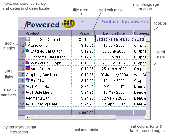
This java Data Grid Control applet enables the display of data in rows and columns in java & web applications. Powerful features include Fast Sorting, Data Acquisition, URL Hyperlinks, Embedded Images, Column Totalling and much more. Enables Dynamic interaction with other page components via JavaScript and special methods. The java data Grid component is very efficient, at just 19...
Category: Business & Finance
Publisher: Sirius Computer Consultants Limited, License: Shareware, Price: USD $49.00, File Size: 182.4 KB
Platform: Windows, Linux, OS/2, Mac, Unix, MS-DOS
Dapfor.Net Grid is a specialized control that displays data as a series of rows and columns known as a tabular format.Originally the Grid was designed for electronic financial markets with their stringent requirements to robustness, low consumption of memory and CPU resources, ergonomic and simple user interface and rich API.
Category: Business & Finance / Business Finance
Publisher: Dapfor, License: Shareware, Price: USD $695.50, File Size: 23.1 MB
Platform: Windows
Imports gridded data into Microsoft MapPoint, to produce attractive data maps that resemble contour maps.
Can handle imperfect data, holes, re-gridding, etc. Can be used to import such attributes as pollution data, seismic hazard, geological information, customer/population distribution, etc.
Data can be interpolated to different Grid spacings if required. Polygon optimization...
Category: Business & Finance / Applications
Publisher: Winwaed Software Technology, License: Shareware, Price: USD $75.00, File Size: 2.2 MB
Platform: Windows
Shareware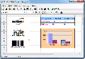
FlexCell is a flexible and easy to use Grid control. Using FlexCell Grid Control, you can create the professional user interfaces and report form in your application. FlexCell Grid Control provides comprehensive functions such as Print, Print Preview, Chart, Merge Cell, Virtual Grid, Sort, Import (from) and Export (to) XML, Export to Excel Workbook (no need of...
Category: Software Development
Publisher: FlexCell Technologies, License: Shareware, Price: USD $129.00, File Size: 2.4 MB
Platform: Windows
Program shows you an actual X3 sector-map, with detailed information about most in-game objects.
Program shows you an actual X3 sector-Map, with detailed information about most in-game objects. The Map is based on a log-file that is created with an in-game script (by Andrei[<>Ace]). If you just want to view the standard Map (or if you don’t have the game) the program will work with the included default Map, which was created with an English X3 game...
Category: Games / Misc. Games
Publisher: SUU Design, License: Freeware, Price: USD $0.00, File Size: 1.4 MB
Platform: Windows
New Zealand Map Reference Converter (NZMapConv) is software that LINZ provides to convert Map references between the old NZMS260 Map series and the new NZTopo50 Map series.NZMapConv is a Windows programme designed to convert individual coordinates entered manually.
Category: Multimedia & Design / Media Management
Publisher: Land Information New Zealand, License: Freeware, Price: USD $0.00, File Size: 2.4 MB
Platform: Windows
When the XMAP software is communicating with an XEDE via the comms cable each Map will show, at the top of the Map display, an RPM and load value (x and y axis for the Map) in real time. Also in each Map a yellow highlighted block will show the current position within the Map. Beside the real-time display on each Map are the undo and redo buttons which...
Category: Home & Education / Miscellaneous
Publisher: ChipTorque, License: Freeware, Price: USD $0.00, File Size: 1.7 MB
Platform: Windows
Sig Panama Has :
Digital maps of Panama, Digital Map of Panama-City, digital Map of Taboga, digital Map of Bocas del Toro, digital Map of Colon and Free Zone, digital Map of Contadora Island, digital Map of Coronado, Panama, Zona Libre, Map of Panama, Map of Panama City, Map of Colon, Map of Zona Libre, Map of...
Category: Internet / Misc. Plugins
Publisher: DP Imperial, LLC., License: Freeware, Price: USD $0.00, File Size: 44.9 MB
Platform: Windows
GEOPosCalc is an easy to use and powerfull tool for coordinate systems (grid) and datum conversion.
GEOPosCalc is an easy to use and powerfull tool for coordinate systems (Grid) and datum Conversion. It does support more than 200 predefined datums, 20 ellipsoids and 10 coordinate systemsand the ability to define your own datums and ellipsoids.
Category: Home & Education / Science
Publisher: American Outland, License: Shareware, Price: USD $40.00, File Size: 4.7 MB
Platform: Windows
EasyMap VCL is a Delphi/C++Builder components set for creating your own GIS-related solutions without MapInfo, MapX, MapObjects, WinGIS and so on. EasyMap VCL allows to add following functionalities in Delphi/C++Builder application: - MIF/MID vector maps displaying in Longitude/Lantitude projection; - Map objects related data in Grid or tabular controls displaying; -...
Category: Software Development / Tools & Editors
Publisher: MicroOLAP Technologies LTD, License: Shareware, Price: USD $79.95, File Size: 2.3 MB
Platform: Windows
Lighting Grid Game is a free and nice board game with some nice features.
Lighting Grid Game is a free and nice board game with some nice features.
It is a small but funny game.Click on a Grid, it will be surrounded by four Grid of colors from white to black or from black to white. Check all changed when the 25 Black, the game victory! Come on!
Category: Games / Misc. Games
Publisher: 365freesoft.com, License: Freeware, Price: USD $0.00, File Size: 1.0 MB
Platform: Windows
Freeware
Convert ESRI ShapeFiles (.SHP) geolocation data into AnyMap format to be used with AnyChart. AnyChart Flash Map Converter allows making use of a wide choice of maps with AnyChart Flash Component, a GIS visualization system that recognizes Map data in AnyMap format only. AnyChart Flash Map Converter makes it easy to visualize any geolocation data without hefty expenses...
Category: Web Authoring / Image Mapping Tools
Publisher: AnyChart.Com, License: Freeware, Price: USD $0.00, File Size: 1.6 MB
Platform: Windows
Design the rug with many drawing tools.
Design the rug with many drawing tools.
- Drawing tools -- triangles, rectangles, circles
- Free-hand drawing and erase
- Fill with solid, hatching or raised outline
- Zoom
- Grid lines based on warps
- Flexible snaping for cleaner drawing
- Copy and Paste
- Multiple levels of Undo
- Color Replacer
- Associate Yarn company or...
Category: Multimedia & Design / Multimedia App's
Publisher: Canyon Art, License: Shareware, Price: USD $95.00, File Size: 1.0 MB
Platform: Windows
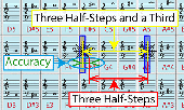
The Pitch Grid Test is a relative pitch test that evaluates your ability to discriminate pitch-distances. For the test, the notes are laid out in form of a Grid: There are 4 rows of octaves starting from C2 to C5. The number of columns depends on the selected the Grid sensitivity. E.g. 100 cents correspond to 12 columns (chromatic scale); 33 cents correspond to 36 columns....
Category: Home & Education / Teaching Tools
Publisher: AlgorithmsAndDatastructures, F. Rudin, License: Freeware, Price: USD $0.00, File Size: 65.5 MB
Platform: Windows
Time Zones Map is the flash world time Map featuring the time peculiarities of more then 50 cities all over the world. Its eye-catching but still pleasant design, varied functions and multiple application abilities combine everything the ultra-modern flash world time Map must have. You can put our Time Zone Map either on one of your website?s pages or put a banner,...
Category: Web Authoring / Flash Utilities
Publisher: USFlashMap.com, License: Shareware, Price: USD $249.00, File Size: 45.0 KB
Platform: Windows, Mac, Linux, Unix, MS-DOS, AS, 400

The free AvisMap Viewer opens most GIS/CAD and raster image file types and most ArcView, ArcExplorer, and MapInfo projects. Besides just opening and viewing files, the Viewer supports an extensive list of features including visual layer properties control, legend control, thematic mapping, spatial and attribute querying, custom labeling, on-Map measurements, hyper-linking, PDF export...
Category: Software Development / Components & Libraries
Publisher: AvisMap GIS Technologies, License: Freeware, Price: USD $0.00, File Size: 22.3 MB
Platform: Windows
Main Features:
- 3D and 2D Map based user interface
- Units are individual, section, or platoon/battery sized units
- Click on the 3D Map to issue unit movement waypoints
- Multiple players over LAN and Internet, each controlling specific forces
- Real time with 30 second time steps, time compression adjustable up to x1,000
- Detailed...
Category: Games / Strategy & War
Publisher: Historical Software Corporation, License: Freeware, Price: USD $0.00, File Size: 173.0 MB
Platform: Windows
Sudoku is a 9x9 Grid. In the newspaper each day, they may fill in 20-30% of the 81 numbers in the Grid. Your goal is to fill in the remaining numbers. Each row, column, and 3x3 subgrid must contain each of the digits from 1 through 9 without any digits repeating.
Category: Home & Education / Miscellaneous
Publisher: Mike Oldroid, License: Freeware, Price: USD $0.00, File Size: 188.8 KB
Platform: Windows
The easiest way to get a paper map with MapPlot is the Plot Map menu.
The easiest way to get a paper Map with MapPlot is the Plot Map menu.
On the following dialog, simply paper size and scale have to be chosen - the result is ready to be printed directly, edited (e.g. for additional entries) or to be displayed as a preview.
Category: Utilities / Misc. Utilities
Publisher: AGIS GmbH, License: Freeware, Price: USD $0.00, File Size: 5.4 MB
Platform: Windows
With LocationWizard you can easily map multiple addresses on a map.
With LocationWizard you can easily Map multiple addresses on a Map. LocationWizard helps you visualize the locations of customers or shops. LocationWizard supports the following database formats: MySQL, PostgreSQL, SQLite, FireBird, InterBase, Microsoft Access, Microsoft Excel and CSV.
Category: Business & Finance / Business Finance
Publisher: Location Wizard team, License: Shareware, Price: USD $85.00, File Size: 7.3 MB
Platform: Windows