Free Downloads: Multiple Files Garmin Image
The GPS map will help you give you with turn by turn directions to your destination using a POI, city point and/or longitude and latitude.It has the ability to preplan driving destinations before getting into your car. Compatible with ALL Garmin GPS units. Don't pay more than US$10 per day when you already own a Garmin, this is the most comprehensive GPS map available at such...
Category: Home & Education / Miscellaneous
Publisher: GPSTravelMaps.com, License: Shareware, Price: USD $0.00, File Size: 0
Platform: Windows
MetroGold is a Windows tool with which you can upgrade your Garmin MetroGuide Europe or Metroguide North America installation. After the upgrade it's possible to include routing calculation data in your upload of maps to your GPS. No extra software, apart from Mapsource, is needed, you can transfer the maps with Mapsource.
Category: Utilities / Misc. Utilities
Publisher: Geodude, License: Shareware, Price: USD $0.00, File Size: 0
Platform: Windows
PoiEditor is a software solution package for downloading and customizing road safety data.
PoiEditor is a software solution package for downloading and customizing road safety data. The software makes it easy to stay up to date with the latest road safety data also know as POI's(Points of interest), it also applies your personal preferences to the downloaded data. The PoiEditor also sends the data to your Garmin device or SSD Card by utilizing the Garmin Poi loader...
Category: Internet / Misc. Plugins
Publisher: Tinus Strauss, License: Shareware, Price: USD $12.59, File Size: 2.7 MB
Platform: Windows
DNRGarmin is a smart tool used to directly transfer data between Garmin GPS handheld receivers and various GIS software packages.
DNRGarmin was built to provide users the ability to directly transfer data between Garmin GPS handheld receivers and various GIS software packages. Using DNRGarmin a user can use point features (graphics or shapefile) and upload them to the...
Category: Utilities / Misc. Utilities
Publisher: GIS Section, Minnesota Department of Natural Resources, License: Freeware, Price: USD $0.00, File Size: 11.3 MB
Platform: Windows
 Shareware
Image Sorter - is award-winning software to Sort Images. Want to sort images? Then you need Image sorter. This automatic Image file sorter and Image sorter tool, Image sorter software and Image sorter program, cutting-edge Image sorter solution and the high-end Image sorter can sort all Image Files. This Image sorter...
Category: Multimedia & Design / Media Management
Publisher: Ridorium Corporation, License: Shareware, Price: USD $39.95, File Size: 14.3 MB
Platform: Windows
Convert Multiple Text Files To Image Files Software is an application that will let you convert many text Files into different Image formats. The program supports batch conversion and is very easy to use. You can add an entire folder and get all of its text Files converted into Image Files.
Category: Multimedia & Design / Media Management
Publisher: Sobolsoft, License: Shareware, Price: USD $0.00, File Size: 2.5 MB
Platform: Windows
Whether you're exploring new coastline or cruising your favorite bay, BlueChart Atlantic contains the most detailed marine cartography around. These electronic nautical maps give you peace of mind when navigating offshore.
The BlueChart Atlantic CD-ROM includes coverage for several offshore regions — select one of these regions to view and download charts with this purchase....
Category: Home & Education / Miscellaneous
Publisher: Garmin Ltd or its subsidiaries, License: Shareware, Price: USD $0.00, File Size: 0
Platform: Windows
AdriaROUTE Lite version of map is made without Garmin NT technology so users with older device can use AdriaROUTE map. Some of devices that not support NT technology are: (eTrex Legend, eTrex Vista, eTrex LegendC, eTrex VistaC, GPSMAP 60C, GPSMAP 60CS, CPSMAP 76C, GPSMAP 76CS, iQue3600; iQue M4; iQue M5..).
Category: Utilities / Misc. Utilities
Publisher: Navigo Sistem d.o.o., License: Freeware, Price: USD $0.00, File Size: 149.6 MB
Platform: Windows
The Windows PC shareware program for Garmin and Magellan GPS receivers.
The Windows PC shareware program for Garmin and Magellan GPS receivers.
Main Features:
- transfer your waypoints, routes, and tracks from and to the GPS receiver, and save it on your computer disk
- review your waypoints
- enter and edit your waypoints
- define your routes and get the estimated traveling time
- review and edit your...
Category: Home & Education / Miscellaneous
Publisher: Heinrich Pfeifer, License: Freeware, Price: USD $0.00, File Size: 2.9 MB
Platform: Windows
MapToaster Topo New Zealand is New Zealand's only topographical mapping suite, with options for your computer and Garmin GPS, including:
- all the rich detail of the LINZ topo maps - seamless across NZ. Now includes Topo50 and Topo250 map series.
- 1:50,000 though 1:2 million scale maps on your PC and 1:50,000 on your GPS
- integrated aerial and satellite...
Category: Home & Education / Miscellaneous
Publisher: Integrated Mapping Ltd, License: Shareware, Price: USD $0.00, File Size: 38.5 MB
Platform: Windows
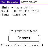
Card Reader allows to use Palm-powered handhelds as an ordinary USB card reader for quick and easy file exchange. It has the unique ability to export the card in the background mode allowing you e.g. to transfer MP3s simultaneously with web browsing. Supported devices : palm T|X; Treo 600; Treo 650; Tungsten|T5; Tungsten|T3; Tungsten|E2; Tungsten|E; GSL Xplore M68; Tungsten|C; Zire 31; Zire...
Category: Utilities
Publisher: Mobile Stream, License: Shareware, Price: USD $11.95, File Size: 29.0 KB
Platform: Palm

Geocode digital images with latitude, longitude, altitude, and direction information when collecting GIS field data. RoboGEO stamps this information onto the actual photo or writes it to the EXIF headers, allowing you to permanently geotag and link your photos to the GPS coordinates. All writing to the EXIF and IPTC headers is lossless and all of the existing comments (including the MakerNote...
Category: Multimedia & Design
Publisher: Pretek, Inc., License: Demo, Price: USD $34.95, File Size: 6.4 MB
Platform: Windows
GPSMapEdit is an application designed for visual authoring of GPS-maps in various cartographic formats: Polish format, Garmin MapSource, Lowrance MapCreate, Navitel Navigator (navigation software for Windows Mobile, Android, Symbian, iPhone), ALAN Map 500/600, Holux MapSho, and custom POIs and speedcams.
The program may also load and convert GPS-tracks, waypoints and routes...
Category: Utilities / Misc. Utilities
Publisher: Konstantin Galichsky, License: Shareware, Price: USD $65.00, File Size: 2.4 MB
Platform: Windows
Multiple Image Resizer .NET allows you to process individual images or folders of images. You can resize, add borders, crop, overlay text, overlay images and/or rotate and flip images. MIR .NET handles a variety of input and output Image formats. Now includes batch Image processing via command line using scripting language. Builtin Update Checking feature.
Category: Multimedia & Design / Authoring Tools
Publisher: Acumen Business Systems Ltd, License: Freeware, Price: USD $0.00, File Size: 9.5 MB
Platform: Windows
How to Organize Image Files - where to get image file organizer?
How to Organize Image Files - where to get Image file organizer? Organize Image Files with the best tool that will teach you how to organize Image Files on your home and office computer, how to organize Image Files in Image collections, how to organize Image Files directly on multimedia players and how to...
Category: Business & Finance / Applications
Publisher: How to Organize, License: Shareware, Price: USD $39.95, File Size: 18.6 MB
Platform: Windows
Flickr Download Multiple Image Files Software can Download one or more images Files from Flickr to a folder. Its core feature is the ability to download Multiple images from a web page at once. All images are selected for download by default. You need to specific a download path for the images before you can use the Save button to save all selected images...
Category: Internet / Download Managers
Publisher: Sobolsoft, License: Shareware, Price: USD $19.99, File Size: 2.6 MB
Platform: Windows
Image Styles allows you to create original images and animations for your website.
Image Styles allows you to create original images and animations for your website. The program comes with a great variety of Image samples that you can use directly or you can modify them to your liking. It includes lots of objects that you can add to your images, such as lines, circles, rectangles. You can even deform these objects, add special effects and filters and adjust...
Category: Multimedia & Design / Multimedia App's
Publisher: Paurex, License: Shareware, Price: USD $99.95, File Size: 5.4 MB
Platform: Windows
Create multiple JPG/JPEG files from multiple image files. .
Create multiple JPG/JPEG files from multiple image files.
Category: Multimedia & Design / Authoring Tools
Publisher: Sobolsoft, License: Shareware, Price: USD $19.99, File Size: 931.8 KB
Platform: Windows
The G600 Trainer is partitioned into three downloads, including a Base Installation, and Add-ons for Garmin SVT™ Synthetic Vision Technology and FlightCharts®. The Base installation should be installed first. The Base installation is required to be installed first.
Category: Games / Simulations
Publisher: Garmin Ltd or its subsidiaries, License: Shareware, Price: USD $159.00, File Size: 654.4 MB
Platform: Windows
Freeware
org, uses file and position names that suit to the display of the TomTom Rider, uses file, route and position names that suit to the display of the Map&Guide Motorrad Tourenplaner, remembers language, paths, window size and position. . .
Category: Business & Finance / Conversion Applications
Publisher: Christian Pesch, License: Freeware, Price: USD $0.00, File Size: 6.6 MB
Platform: Windows, Mac, Linux, Solaris, FreeBSD, OpenBSD, Java
Northwest Trails is a mapset of trails designed for upload to any map-enabled Garmin GPS receiver.
Northwest Trails is a mapset of trails designed for upload to any map-enabled Garmin GPS receiver. It is more than just a mapset, though; it is also a community effort initiated to record and collect GPS data for trails in the Northwest (Washington, Idaho, Oregon, Montana, Wyoming, Alaska, British Columbia and Alberta) and provide that data for general public use.
The mapset...
Category: Internet / Misc. Plugins
Publisher: Jon F. Stanley, License: Freeware, Price: USD $0.00, File Size: 31.7 MB
Platform: Windows

This software offers a solution to users who want to combine Multiple audio Files with Multiple Image Files. Simply add Files to queue individually, by folder, or by drag-and drop. This software can save you hours by processing your WebP Files in batch.
Category: Multimedia & Design / Graphics Viewers
Publisher: Sobolsoft, License: Shareware, Price: USD $19.99, File Size: 24.9 MB
Platform: Windows
With Fast Folder.JPG you can easily assign any Image you choose to the covers of your folders. Drag and drop an Image, or a folder containing Multiple images, into Fast Folder.JPG to create a folder.jpg Image -an Image that changes the default look of folders, replacing it with a picture. The Image you select is automatically resized and named, leaving...
Category: Utilities / Shell Extensions
Publisher: Listening PC, License: Shareware, Price: USD $0.00, File Size: 3.2 MB
Platform: Windows
Shareware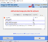
Download and use this powerful Image to PDF conversion software for Windows. Try this tool to convert all types of Image Files to PDF documents safely. A large number of Image Files convert to PDF Files in a single operation without facing a single problem. Amazing features of eSoftTools Image to PDF Converter Software: - (1) Convert a...
Category: Utilities / File & Disk Management
Publisher: eSoftTools Software, License: Shareware, Price: USD $29.00, File Size: 20.2 MB
Platform: Windows
Shareware
Put a watermark image on top of many images files at once.
Put a watermark Image on top of many images Files at once. The background of the watermark Image can be made to be transparent.
Category: Multimedia & Design / Authoring Tools
Publisher: Sobolsoft, License: Shareware, Price: USD $19.99, File Size: 751.1 KB
Platform: Windows