Free Downloads: Nmea Software
 Shareware
ZylGPSReceiverAX is an an award-winning ActiveX control that communicates with a serial GPS receiver. It returns latitude, longitude, altitude, speed, heading and many other parameters of the position. This control works with any Nmea compatible receiver connected to one of the serial ports. You can use it also with USB devices, because these devices usually have a driver that...
Category: Software Development / ActiveX
Publisher: Zyl Soft, License: Shareware, Price: USD $99.99, File Size: 863.4 KB
Platform: Windows
A program to convert GPS-track of *. gpx, *.
mps, *. plt or *. nmea format to Navitel Tracks.
Category: Home & Education / Sports
Publisher: DXsoft, License: Freeware, Price: USD $0.00, File Size: 31.6 KB
Platform: Windows
Shareware
Toolkit to add GPS functionality to your Software and scripts (GPS SDK). All NMEA0183 protocol versions are supported and can be filtered by Nmea sentence type and talker ID. Information on GPS status can also be retrieved: GPS fix quality, satellites used in fix, satellites in view, satellite azimuth, elevation and signal strengths. The toolkit also offers functionality to...
Category: Software Development / ActiveX
Publisher: Eye4Software B.V., License: Shareware, Price: USD $150.81, File Size: 1.6 MB
Platform: Windows
Win/CE GPS client library component reads and decodes standard GPS Nmea 183 sentences from the RS232 serial port as well as compute great circle distances and bearings. Several eVC example programs with full source code are included. Requires Windows Embedded Tools eVC compiler. Some of the many features of the MarshallSoft GPS Component (MGC) are: (1) Uses the Win/CE Win32 API for...
Category: Software Development / Tools & Editors
Publisher: MarshallSoft Computing, License: Shareware, Price: USD $105.00, File Size: 256.0 KB
Platform: Windows,
The KML Generator is a useful and reliable utility which enables you to easily analyze GPS log files containing Nmea string data and then generate Google Earth (TM) compatible KML files. It is a free to use application and has a simple and friendly interface. It has low system requirements too, and works on all windows operating systems.
Category: Software Development / Misc. Programming
Publisher: Jacob Madsen, License: Shareware, Price: USD $0.00, File Size: 0
Platform: Windows
NemaTalker provides both user and developer of Nmea soft and hardware with a very powerful development and testing tool by simulating the output of a large number of nautical instruments, including GPS.
The program can be successfully used for educational purposes as well.
Category: Internet / Misc. Plugins
Publisher: Sailsoft, License: Shareware, Price: USD $59.00, File Size: 1.8 MB
Platform: Windows
NemaStudio provides the professional developer of Nmea products with a very powerful development and testing tool by simulating the output of various nautical instruments and target objects including GPS, AIS and Radar.
All instruments, targets and ports can be matched and mixed, meaning you can have multiple instances of several objects transmitting over the same or over...
Category: Software Development / Misc. Programming
Publisher: Sailsoft, License: Shareware, Price: USD $345.31, File Size: 2.4 MB
Platform: Windows
Shareware
MarshallSoft GPS Component Visual Basic and .NET toolkit to read and decode industry standard GPS Nmea 183 navigation sentences from the RS232 serial port as well as computes great circle distances and bearings. Features include: - Supports both 32-bit and 64-bit Windows. - Uses the Windows API for serial port input. No special Windows driver is required. - Runs as a...
Category: Software Development / Components & Libraries
Publisher: MarshallSoft Computing, License: Shareware, Price: USD $115.00, File Size: 476.8 KB
Platform: Windows
MarshallSoft GPS Component VB (and VB.NET) library toolkit (MGC4VB) reads and decodes industry standard GPS Nmea 183 sentences from the RS232 serial port as well as computing great circle distances and bearings. Features of MGC4VB include: The most current GPS data is always available on demand * Runs as a background thread unattended * Works with Bluetooth virtual serial ports * Works...
Category: Software Development
Publisher: MarshallSoft Computing, License: Shareware, Price: USD $105.00, File Size: 233.4 KB
Platform: Windows
Yet another tool to read and convert GPS logs from Royaltek RGM-3800 and RBT-2300 (using serial communication), from RBT-3000 (using files), from Nmea logs files (comming from AMOD 3080 datalogger for example). Free download and easy to install. Enjoy.
Category: Utilities / Misc. Utilities
Publisher: eXtraGPS, License: Freeware, Price: USD $0.00, File Size: 2.5 MB
Platform: Windows
Kinomap GPS File Fixer allows you to process some treatments on GPS file:
- convert almost any GPS file to standard Nmea 0183, compatible with Kinomap
- fill the gaps between points when your file is not 1Hertz: the extra point will be recreated by interpolation
- cut a long file in which there are loops of data (example: race) in several parts
Category: Home & Education / Miscellaneous
Publisher: ExcelLance, License: Freeware, Price: USD $0.00, File Size: 19.6 MB
Platform: Windows
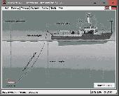
DRAGSENS Geo Software is used for the exact position estimation of a towed body, sensor, camera, array or net, dragged behind a ship, aircraft or vehicle. The Software allows a real-time estimation of the position of a dragged sensor based on the location of a GPS-receiver. The sensor thereby can be dragged underwater, at water or earth surface or be airborne. The Software...
Category: Home & Education / Science
Publisher: Killet Software Ing.-GbR, License: Shareware, Price: USD $145.00, EUR130, File Size: 2.0 MB
Platform: Windows
NMEATime will automatically set your PC clock using a GPS receiver connected to the serial port of a PC or to the National Institute of Standards and Technology (NIST) time servers over the Internet.
Features:
- Digital desktop time code clock - like NASA has!
- Analog desktop clock
- Uses GPS Time to set your PC clock
- Nmea 0183 v2.20 -...
Category: Home & Education / Alarm Applications
Publisher: VisualGPS, LLC., License: Shareware, Price: USD $20.00, File Size: 1.1 MB
Platform: Windows
HsGpsDll is a Windows Dynamic Link Library which provides access to any Nmea-183 compliant GPS receiver via a serial communications port.
HsGpsDll is designed for use from Visual C, C++, Visual C Sharp .NET, Visual Basic or other programming languages, capable of calling DLL functions.
HsGpsDll allows a user application to easily read from a GPS device the...
Category: Business & Finance / Business Finance
Publisher: Hillstone Software, License: Shareware, Price: USD $270.58, File Size: 700.6 KB
Platform: Windows
Ais Decoder accepts AIS data from an AIS Receiver, the Internet or a Local Network connection, decodes the data and presents the decoded data in a form suitable for display and analysis by mapping program (eg Google Earth or Google Maps), or for analysis using Excel, or by a database (eg MySql).
The decoder will decode all the Nmea content of all 27 AIS mesage types. The...
Category: Business & Finance / Business Finance
Publisher: Neal Arundale, License: Freeware, Price: USD $0.00, File Size: 2.8 MB
Platform: Windows
Emulator for Maretron's DSM250, a high-resolution sunlight viewable color display that allows easy interpretation of Nmea 2000® instrument and navigation data through custom display configurations, featuring an easy-to-use five-key illuminated keypad.
Unlike traditional single-display units, DSM250 users can choose numeric, gauge, or graph formats in single or multiple...
Category: Business & Finance / Applications
Publisher: Maretron LLP, License: Demo, Price: USD $0.00, File Size: 1.6 MB
Platform: Windows

MB-GPS2KML converts a GPS log file (in plain NMEA format) to a KML file (placemark file for Google Earth) and opens this file in Google Earth. Velocity, number of satellites and HDOP are interpreted as height, color and size of the icons.
Category: Home & Education
Publisher: Markus Bader, License: Freeware, Price: USD $0.00, File Size: 441.4 KB
Platform: Windows
GPS log-maker. Software creates *.plt track file, *.rte route file and, optionally, Nmea-log file.
Category: Internet / SMS
Publisher: dxsoft.com, License: Freeware, Price: USD $0.00, File Size: 85.8 KB
Platform: Unknown
Shareware
ZylGPSReceiver.NET is an event driven .NET component that communicates with a GPS receiver. It returns latitude, longitude, altitude, speed, heading and many other useful parameters of the current position and the parameters of the satellites in view. The component is extended to calculate distances and make conversions between different measurement units. This component works with any...
Category: Software Development / Components & Libraries
Publisher: Zyl Soft, License: Shareware, Price: USD $99.99, File Size: 1.1 MB
Platform: Windows
NovaGPS provides manual or automatic setting of time and location from consumer-grade (or better) GPS receivers. NovaGPS is not the same as Dr. Tom Clark's Totally Accurate Clock because NovaGPS does not require a specialized GPS receiver or modification to other GPS receivers.
Instead, NovaGPS offers accuracy to better than 0.5 seconds using off-the-shelf GPS receivers such...
Category: Home & Education / Miscellaneous
Publisher: Northern Lights Software Associates, License: Shareware, Price: USD $19.95, File Size: 1.0 MB
Platform: Windows
AudioCompass is a navigation program for visually-impaired sailors.
AudioCompass is a navigation program for visually-impaired sailors.
AudioCompass is a simple program: it connects to a vessel’s Nmea-0183 data network, and displays heading course and waypoint information on a compass dial.
Audio tones are generated to assist in the steering of the boat, and speech annunciation is provided for
the relevant navigation data.
Category: Business & Finance / Business Finance
Publisher: Four Fathom Marine Technology, License: Freeware, Price: USD $0.00, File Size: 418.5 KB
Platform: Windows
GeoVisu is a program that displays georeferenced data (images, graphics) and downloads data recorded by some GPS devices.
GeoVisu has a "Moving map" navigation function, which can be used with any Nmea 0183 compatible or Garmin USB GPS device.
Main features:
- Displays georeferenced image formats : GeoTiff, ECW and ECWP, MrSID, OziExplorer...
Category: Multimedia & Design / Graphics Viewers
Publisher: GeoVisu, License: Freeware, Price: USD $0.00, File Size: 1.7 MB
Platform: Windows
The fast track to GPS success.
The fast track to GPS success. The Linx MDEV-GPS-SR contains everything needed to rapidly evaluate the SR Series GPS modules and implement them in record time. This all-inclusive Master Development System features a pre-assembled development board with an on-board OLED display for standalone testing. The system can also be attached to a PC via USB and operated using the supplied...
Category: Software Development / Misc. Programming
Publisher: Linx Technologies, Inc., License: Freeware, Price: USD $0.00, File Size: 98.5 MB
Platform: Windows
VisualGPSXP is a general purpose utility for monitoring the output of a GPS receiver.
VisualGPSXP is a general purpose utility for monitoring the output of a GPS receiver. Using the Nmea data from the GPS receiver, VisualGPSXP will display various statuses graphically.
Tools such as a survey utility average the position and shows accuracy of the GPS receiver in a static application.
Main features:
- Multiple connection paths to a...
Category: Home & Education / Miscellaneous
Publisher: VisualGPC, License: Shareware, Price: USD $25.00, File Size: 1.1 MB
Platform: Windows
This program was designed to check the installation and optimize placement of the antenna for your Automatic Identification System (AIS). This program displays received signal, threshold and signal-to-noise ratio (SNR) data for selected AIS targets. The program has been tested with NASA Marine Instrument's AIS Engine using the standard Nmea 0183 interface.
Category: Utilities / Misc. Utilities
Publisher: The Bellwood Group, License: Freeware, Price: USD $0.00, File Size: 2.2 MB
Platform: Windows