Free Downloads: Program For Latitude On Earth
The Earth is probably the best planet I?
The Earth is probably the best planet I?ve ever been to, so I like to keep abreast of what?s going on in the world. I found this desktop background great for monitoring cloud cover, the advance of day and night and nocturnal lights around the globe.
Category: Desktop Enhancements / Wallpaper
Publisher: codefromthe70s.org, License: Freeware, Price: USD $0.00, File Size: 6.2 MB
Platform: Windows
AZMap is a freeware Windows Program which will generate, and display an Azimuthal-Equidistance map of the world, centered on any point on the surface of the Earth (except very near the poles). The A-E map is also known as a Great Circle map since straight lines from the center point to any other point always fall along a great circle path and represent the shortest distance...
Category: Home & Education / Miscellaneous
Publisher: Paul Burton, License: Freeware, Price: USD $0.00, File Size: 1.1 MB
Platform: Windows
Geozip calculates distance between US (optionally Canadian) zip codes or geographical coordinates, Latitude and longitude. It does take into account the curvature of the Earth for calculating. You can choose miles, kilometers or nautical miles output. Customixation is available if you need more specific applications using the Geozip geographical distance calculations.
Category: Business & Finance
Publisher: Island Limited, License: Shareware, Price: USD $49.00, File Size: 2.3 MB
Platform: Windows
Latitude ON is an Instant on or splashtop mini operating system offered by Dell on their new E-Series portables, there are two version of the solution, the first one, just called Latitude ON, its a hardware solution based on a chip integrated on the systemboard that fulfills basic user needs such as browsing the internet, working with office documents, windows calendar, mail and...
Category: Utilities / Misc. Utilities
Publisher: Dell, License: Shareware, Price: USD $0.00, File Size: 0
Platform: Windows
GPicSync automatically inserts location in your photos metadata so they can also be used with any 'geocode aware' application like Picasa/Google Earth, Flickr, loc.alize.us.
Main fetures:
- automatically geocode your photos (in the EXIF header)
- use a GPS tracklog in the GPX format or NMEA format (multiple selection possible)
- Support elevation...
Category: Multimedia & Design / Digital Media Editors
Publisher: Google Project, License: Freeware, Price: USD $0.00, File Size: 0
Platform: Windows
Salat calculates the prayer times for your location.
Salat calculates the prayer times for your location.
If your city is not in the database (unlikely, since it has 36,000 cities in it), just feed it the Latitude and longitude of your place (Get that from Google Earth) and it will calculate the times of Namaz.
Options for calculating according to Hanafi and Shafe'ee schools of Jurisprudence.
Category: Games / Misc. Games
Publisher: IQSoft Software Consultants, License: Freeware, Price: USD $0.00, File Size: 15.9 MB
Platform: Windows
Manifold Toolbar is a powerful and handy application that allows you to view a map or satellite image of any place on Earth directly on your browser without the need of any other Program. You just have to type a location (city and country, city and state) in the search bar and it automatically displays satellite images or street maps, allowing you zoom in and out to see more...
Category: Internet / Browser Accessories
Publisher: CDA International, License: Freeware, Price: USD $0.00, File Size: 1.5 MB
Platform: Windows
The program offers comfortable data input with permanent presentation of the system on the screen.
The Program offers comfortable data input with permanent presentation of the system on the screen. Every change of data is shown on the screen, so that optimum control of input data is given. The many means of graphic presentation, to a high standard of quality, make it possible for you to show your calculation results exactly as you wish to.
Main Features:
- Up to 50...
Category: Business & Finance / Business Finance
Publisher: Civilserve GmbH, License: Shareware, Price: USD $0.00, File Size: 0
Platform: Windows
 Demo
Demo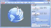
Only flying is more beautiful. Enjoy your travels for a second time with a flight over the globe. Simply insert start and destination point, the rest is handled by our AquaSoft Earth Pilot. This brand new AquaSoft Program connects to Google Earth and produces your video. This works as easy as if a flight simulator lets you hover above the Earth, and finally your...
Category: Audio / Music Creation
Publisher: AquaSoft GmbH, License: Demo, Price: USD $19.90, EUR19.9, File Size: 7.2 MB
Platform: Windows
IP2Location IP-COUNTRY-REGION-CITY-Latitude-LONGITUDE-TIMEZONE-NETSPEED is commercial lookup database that translates IP address to country, region, city, Latitude, longitude, time zone and connection speed. Developers use this database for: 1. Provide Location Aware Content (language, currency, etc.) 2. Redirect based on country; 3. Digital rights management;...
Category: Software Development / Debugging
Publisher: IP2Location.com, License: Data Only, Price: USD $1099.00, File Size: 195.3 KB
Platform: Windows, Linux, Palm, Mac, Unix, MS-DOS, AS/400, OS/2, OpenVMS
A Journey To The Center Of The Earth, by Jules Verne (1864)Prof.
A Journey To The Center Of The Earth, by Jules Verne (1864)Prof. Lindenbrook leads his intrepid party on an expedition to the centre of the Earth, via a volcano in Iceland, encountering all manner of prehistoric monsters and life-threatening hazards on the way.
Category: Home & Education / Miscellaneous
Publisher: Southern Ocean Software, License: Freeware, Price: USD $0.00, File Size: 747.5 KB
Platform: Windows
The Latitude Network Video Management System (NVMS) is a fully Scalable enterprise-class media management system. This advanced network based system architecture enables simultaneous live monitoring from multiple stations and is easily configurable for storage both on and off site. The software can be configured to store and to view from one to thousands of cameras and monitor...
Category: Internet / Chat
Publisher: DVTel Inc., License: Shareware, Price: USD $0.00, File Size: 0
Platform: Windows
Satellite earth is a software for viewing satellite and aerial imagery of the Earth.
Satellite Earth is a software for viewing satellite and aerial imagery of the Earth.Satellite Earth allows you to enjoy virtual travel around the world, look up local information and plan trips, exploring multimedia content and share information about your trips.Explore towns, cities and terrain relief shown in three-dimensional images of high resolution associated with...
Category: Home & Education / Science
Publisher: www.satelliteview-of-my-house.com, License: Freeware, Price: USD $0.00, File Size: 584.0 KB
Platform: Windows
IP2Location IP-COUNTRY-REGION-CITY-Latitude-LONGITUDE-ZIPCODE-TIMEZONE is commercial lookup database that translates IP address to country, region, city, Latitude, longitude, ZIP code and time zone. Developers use this database for: 1. Provide Location Aware Content (language, currency, etc.) 2. Redirect based on country; 3. Digital rights management; 4....
Category: Web Authoring / Web Design Utilities
Publisher: IP2Location.com, License: Data Only, Price: USD $649.00, File Size: 195.3 KB
Platform: Windows, Linux, Palm, Mac, Unix, MS-DOS, AS/400, OS/2, OpenVMS
Sonic and Tails have crashed into Earth and have transformed into humans and changed their name to fit in. Race to the end of each level destroying enemies and collecting stars on the way. Be careful the evil Dr. Robotnik has followed you to Earth! Use the space bar to jump, and press down plus space bar to do a power spin and use the arrow keys to move!
Sonic Earth...
Category: Games / Arcade
Publisher: softendo.com, License: Freeware, Price: USD $0.00, File Size: 7.4 MB
Platform: Windows
Seismic Waves is a Windows Program which illustrates how wave propagate from an earthquake hypocenter to seismic stations throughout the Earth. One sees waves propagating out from the epicenter on a three-dimensional view of the Earth at the same time one sees waves propagating through a cross-sectional view of the Earth. These two wave propagation views are...
Category: Home & Education / Science
Publisher: Alan L. Jones, License: Freeware, Price: USD $0.00, File Size: 2.6 MB
Platform: Windows
Mirkwood - Middle Earth Tale 3.
Mirkwood - Middle Earth Tale 3. A finished Tolkien inspiredRPG that features a journey through the dark forrest in Middle Earth called Mirkwood. Get ready for adventure, get ready to change history, get ready to play Mirkwood!
Category: Games / Adventure & RPG
Publisher: jockethebeast.phatcode.net, License: Freeware, Price: USD $0.00, File Size: 317.0 KB
Platform: Unknown
Korti is a Google Earth plugin which allows you to see the unique 3D satellite map of Korti within your Google Earth application.
Korti provides you a detailed satellite imagery and geographic information about this geographic place.
To have Korti installed on your PC, first install for free Google Earth and then Korti 3D map plugin. After that, simply double...
Category: Multimedia & Design / Multimedia App's
Publisher: Maplandia, License: Freeware, Price: USD $0.00, File Size: 309 B
Platform: Windows
In 2049, the human population of Earth embarks on a migratory voyage to try to colonize other planets. They leave mechanical "orbots" to clean up the mess they made on Earth through littering and pollution.
Raster, a high-level orbot who watches Earth through a planetwide computer network, is accidentally attached to a working nuclear missile by a...
Category: Games / Action
Publisher: segabandonware, License: Freeware, Price: USD $0.00, File Size: 1.5 MB
Platform: Windows
IP2Location IP-COUNTRY-REGION-CITY-Latitude-LONGITUDE-ZIPCODE-ISP-DOMAIN is commercial lookup database that 1. Provide Location Aware Content (language, currency, etc.) 2. Redirect based on country; 3. Digital rights management; 4. Prevent password sharing and abuse of service; 5. Reduce credit card fraud; 6. Web log stats and analysis; 7. Auto-selection of fields on...
Category: Web Authoring / Web Design Utilities
Publisher: IP2Location.com, License: Data Only, Price: USD $799.00, File Size: 195.3 KB
Platform: Windows, Linux, Palm, Mac, Unix, MS-DOS, AS/400, OS/2, OpenVMS
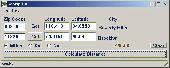
This converter is actually part of Balloon Track.
This converter is actually part of Balloon Track. However, I often found myself needing a quick conversion. Loading BT for this was just a bit cumbersome, so I lifted the converter and made it a Program in its own right.
Enter Latitude and longitude at the top and click the button corresponding to the output you wish to see.
It's simple right?
...
Category: Business & Finance / Calculators
Publisher: EOSS, License: Freeware, Price: USD $0.00, File Size: 248.1 KB
Platform: Windows
Imagenes satelite is a free satelite images slideshow screensaver for your desktop.
Imagenes satelite is a free satelite images slideshow screensaver for your desktop.View high resolution and beautihigh quality satelite images of Earth from space.This screensavers contains full color images that fit automatically on your screen.View satellite images of Earth from several kilometers from above the sky.Fly above the surface of the Earth and see the beauty of...
Category: Desktop Enhancements / Screensavers
Publisher: www.vista-satelite.com, License: Freeware, Price: USD $0.00, File Size: 3.3 MB
Platform: Windows
EasyAcreage is Program for WinXP or Vista Program that allows you to calculate area from KML files exported out of Google Earth. This means you do not even have to leave your house to measure a field anymore. Simply use the free version of Google Earth, mark the area you wish to measure, save it as a KML file and drag and drop it onto EasyAcreage.
Category: Home & Education / Miscellaneous
Publisher: Wildsoft, License: Shareware, Price: USD $20.00, File Size: 817.1 KB
Platform: Windows
Aliens are attacking Earth and you must stop them.
Aliens are attacking Earth and you must stop them. Use your military skills to blast the aliens into submission and save the planet! Cool graphics and upgrades make this an exciting battle!
Category: Games / Action
Publisher: MyRealGames.com, License: Freeware, Price: USD $0.00, File Size: 5.7 MB
Platform: Windows
The Use of Videography in Tracking Earth Satellites.
The Use of Videography in Tracking Earth Satellites.Scattered around the world is a network of about sixteen amateur observers who spend most of their spare time looking at Earth satellites.They concentrate on tracking classified military satellites.Working in close collaboration
this group keeps regular track of about 120 satellites moving in a wide variety of orbits...
Category: Home & Education / Science
Publisher: www.satelliteimage-of-my-house.com, License: Freeware, Price: USD $0.00, File Size: 1.7 MB
Platform: Windows