Free Downloads: Road Map Drawing
GPS Tuner was first launched in 2003.
GPS Tuner was first launched in 2003. Success followed introduction shortly. Over the years it became a best-selling favourite GPS software among off-roaders as a reliable, versatile feature-packed application suiting the needs of outdoor enthusiasts and professional off-Road users alike. After five years of continuous development of previous GPS Tuner versions GPS Tuner Kft. was founded...
Category: Web Authoring / Web Design Utilities
Publisher: GPS Tuner Ltd., License: Freeware, Price: USD $0.00, File Size: 4.5 MB
Platform: Windows
NoeClone Version Basic Edition is an easy to use and flexible plasmid Map Drawing program that generates publication-quality plasmid maps with or without sequence. If Drawing plasmid maps is your primary interest at this stage, you should get this edition at a super-low price.
Category: Multimedia & Design / Image Editing
Publisher: NoeGen, License: Shareware, Price: USD $99.00, File Size: 55.9 MB
Platform: Windows
Cool Flash Map Maker is a powerful Flash Map software for developing interactive flash mapping solutions and products for Real Estate, Spacial Statistics, Business Locator Applications, Vector USA Map,World Map, Germany Map,ASIA Map, Canada Map, Europe Map, Australia Map, Austria Map, Africa Map, UK Map, South...
Category: Multimedia & Design / Multimedia App's
Publisher: Go2Share, License: Shareware, Price: USD $29.95, File Size: 17.9 MB
Platform: Windows
If you've ever wished there were a way to print lists of files and folders, APrintDirect is the application for you. With speed and accuracy, this 32-bit utility lets you print a Road Map of your hard drives' folder and file structure. The user-friendly interface allows for the selection of specific information fields to display for each file/directory listed.APrintDirect's allows...
Category: Utilities / File & Disk Management
Publisher: B & P Technologies, License: Shareware, Price: USD $14.00, File Size: 1.1 KB
Platform: Unknown
In this game there will be a city with some of the numbered buildings shown.
In this game there will be a city with some of the numbered buildings shown. Your task is to construct a Road that loops the city. The Road must not branch and there must only be one loop. The number on a building indicates the number of faces of this building facing a Road. Click at an edge to create a Road, click again to mark that edge with a cross to remind...
Category: Games / Misc. Games
Publisher: Novel Games Limited, License: Freeware, Price: USD $0.00, File Size: 253.7 KB
Platform: Windows
Horrum is a free and simple, yet fun 3D racing game with infinite road.
Horrum is a free and simple, yet fun 3D racing game with infinite Road.
The goal of the game is to set the best time between two check-points. Beware the traps and the end of the Road, and use or don't power-ups on the Road.
This game requires OpenGL 3D accelerator.
Category: Games / Misc. Games
Publisher: Jordan Tuzsuzov, License: Freeware, Price: USD $0.00, File Size: 1.4 MB
Platform: Windows
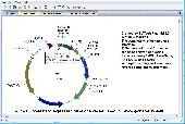
BVTech Plasmid can draw circle or linear plasmid map with double strands or single strand.
BVTech Plasmid can draw circle or linear plasmid Map with double strands or single strand. You can label the plasmid with genes and restriction sites in different colors, text, and styles. Plasmid Map can be highly customized by drag-droping or directly setting properties. BVTech Plasmid provides many Drawing objects, includs lines, arrows, rectangles, circles, and text...
Category: Home & Education / Science
Publisher: BV Tech, Inc., License: Freeware, Price: USD $0.00, File Size: 2.5 MB
Platform: Windows
The program allows the user to rectify photographs of surfaces which are close to being planar, such as roadway surfaces at accident scenes.
Photographs and videos oblique to a surface are transformated into a plan view like a Map. Scanners and digital cameras can be used directly from within the program so the rectification of any kind of picture is possible.
...
Category: Multimedia & Design / Image Editing
Publisher: DSD, License: Shareware, Price: USD $0.00, File Size: 0
Platform: Windows
The Crash Zone is the Drawing program of choice for Accident Reconstructionists and Law Enforcement Officers who need to accurately Map crash scenes.
The Crash Zone has tools for Crash Investigators and Reconstructionists, including easy 3D animations, a vehicle specifications database, skid analysis and momentum calculations, and an easy-to-use 3D body poser.
Category: Multimedia & Design / Image Editing
Publisher: The CAD Zone, Inc., License: Shareware, Price: USD $699.00, File Size: 671.0 MB
Platform: Windows
Create GPS enabled geo maps directly on the background of aereal photos and Road maps from the internet. Import geodata from Google-Earth, OpenStreetMap, GPS tracks and GPS logger. Map editor , manually digitizing. Specifical graphical objects (borderlines, borderareas) to guarantee exact same borders of neighbour areas..Screen calibration for true to display on the screnn.
Category: Multimedia & Design / Digital Media Editors
Publisher: GPSur Dr. Erhard Regener, License: Shareware, Price: USD $65.00, File Size: 6.4 MB
Platform: Windows
Road Doctor™ Viewer is a free software for clients.
Road Doctor™ Viewer is a free software for clients. It can be used to view projects and data views created by Road Doctor™ and Geo Doctor™ software. New views or data cannot be linked to the project. Views created with Road Doctor™ 3D GPR module and single ground penetrating radar files can be opened to the view.
Category: Multimedia & Design / Graphics Viewers
Publisher: Roadscanners Oy, License: Freeware, Price: USD $0.00, File Size: 43.6 MB
Platform: Windows
Dig up some family fun with Lucy's Expedition, an original time-management game from the creators of Little Shop - Road Trip! When pieces of a mysterious Map begin appearing around the world, it's up to Lucy Livingston to track them down. Help Lucy and her team travel the world on their quest for ancient artifacts to trade for the Map pieces. Flex your memory...
Category: Games / Arcade
Publisher: GameHouse, Inc., License: Shareware, Price: USD $0.00, File Size: 33.8 KB
Platform: Windows
ArcGIS for AutoCAD is a free, downloadable plug-in application for AutoCAD that provides improved interoperability between AutoCAD and ArcGIS. Within the AutoCAD environment, you gain easy access to enterprise GIS maps hosted by ArcGIS Server.
In addition, ArcGIS for AutoCAD gives you the ability to prepare CAD data for use with the ArcGIS system while leveraging your existing CAD...
Category: Multimedia & Design / Image Editing
Publisher: Environmental Systems Research Institute, Inc., License: Demo, Price: USD $0.00, File Size: 1.4 MB
Platform: Windows
DRPRO (Drawing Register Professional) is a computerized Drawing & Document Management System for use in a Drawing office environment. It is designed to do the tedious work of maintaining an accurate Drawing and document issue register in a multi-disciplinary Engineering, Architectural or Interior Design practice, or virtually any Drawing office.
Category: Multimedia & Design / Image Editing
Publisher: LDA Computing, License: Shareware, Price: USD $0.00, File Size: 0
Platform: Windows
Primarily, CogoCAD PRO provides an interface so you can download data from survey data collector,import data,add other gis data to your Map digitize points,lines and polygons,design roads meaning you can view Road cross section by segment at any station
Category: Software Development / Misc. Programming
Publisher: CMT Inc., License: Shareware, Price: USD $385.00, File Size: 92.7 MB
Platform: Windows
TwoNav is a dual navigation system (On-Road/Off-Road) to perform most of your outdoor activities (hiking, biking, skiing, geoacaching, ...). TwoNav can also guide you when driving. A single solution for all your orientation needs. Load maps, tracks, routes and waypoints and get ready for your trip!
Category: Home & Education / Miscellaneous
Publisher: CompeGPS TEAM, S.L., License: Shareware, Price: USD $67.28, File Size: 21.2 MB
Platform: Windows
Fractal Mapper is a high-powered mapping system that lets gamers create a wide variety of of maps - dungeons, continents, cities, and more! With it's easy to use interface, powerful features, and unique capabilities, making high quality maps with Fractal Mapper is a breeze!
Main features:
- Fractal based Drawing tools for realistic coastlines, rivers, and...
Category: Games / Tools & Editors
Publisher: NBOS Software, License: Shareware, Price: USD $0.00, File Size: 39.4 MB
Platform: Windows
This Map includes the most detailed and exhaustive coverage of the Angkor Wat area, all temples in the World Heritage Site, and all roads, paths and trails around and between the temples.
The mapset is processed to work seamlessly with all Rotweilermaps.com maps of countries surrounding Cambodia.
The Map includes numerous motorcycle and 4 wheel-drive...
Category: Home & Education / Miscellaneous
Publisher: Cambodia-gps, License: Shareware, Price: USD $0.00, File Size: 0
Platform: Windows
The POI Warner (GoPal 5 or 6-Edition) allows the user to display POI in 2D and 3D Map view and provides acoustic and visual alerts for any given Points-of-Interest. The POI-Warner for GoPal 5/6 is an add-on that enhances your navigation system with essential features. The POI-Warner warns the user acoustically and visually of POI. It is also possible to integrate a large variety of POI...
Category: Multimedia & Design / Multimedia App's
Publisher: navigating GmbH, License: Shareware, Price: USD $39.00, File Size: 3.2 MB
Platform: Windows
With this FREE AutoCAD add-on you can create terrain sections
from geodetic points(heights) in the Drawing. You can also
specify position of pipe(cable, Road, ...) or set auxiliary
marks in the section.
Text settings, scale in X,Y axis, height of the reference
plane and type of the terrain section can be set at start-up.
There are two ways how you can create...
Category: Multimedia & Design / Multimedia App's
Publisher: Cadhedral, License: Freeware, Price: USD $0.00, File Size: 69.0 KB
Platform: Windows
GPS Egypt brings you the best GPS mapping and navigation package on the Egyptian market today with over 55,000 km of Road coverage. The package offers the best Map coverage available in Egypt, in addition to a cutting-edge software package for voice-based routing and navigation.
Category: Internet / Communications
Publisher: GPS Egypt, License: Freeware, Price: USD $0.00, File Size: 135.6 MB
Platform: Windows
AZMap is a freeware Windows program which will generate, and display an Azimuthal-Equidistance Map of the world, centered on any point on the surface of the earth (except very near the poles). The A-E Map is also known as a Great Circle Map since straight lines from the center point to any other point always fall along a great circle path and represent the shortest distance...
Category: Home & Education / Miscellaneous
Publisher: Paul Burton, License: Freeware, Price: USD $0.00, File Size: 1.1 MB
Platform: Windows
Growing global trend in the construction industry today is crossing new borders, especially when it comes to accurate and quick designing and dimensioning. Contracting companies and investors have raised their benchmarks regarding time, value for engineering hours and cost effective construction. To meet these demands they need an automation manager like AEC Roads. Accurate and interactive, AEC...
Category: Business & Finance / Project Management
Publisher: AEC Logic Private Limited, License: Shareware, Price: USD $1500.00, File Size: 7.6 MB
Platform: Windows
A!K Mouse Off-Road is an odometer for your mouse! It tracks movement of the mouse and the time of a mouse activity. All tracked information is shown on the indicator window and may be exported to a .txt file.
Category: Desktop Enhancements
Publisher: sixfiles.com, License: Freeware, Price: USD $0.00, File Size: 474.0 KB
Platform: Windows, Mac, 2K, 2K3
Remere's Map Editor is a map editor for the OpenTibia Project which was created by Remere.
Remere's Map Editor is a Map editor for the OpenTibia Project which was created by Remere.
Remere's Map Editor is a Map editor coded in C to be used with OpenTibia. It supports many advanced features such as autobordering and placing of composite objects. Runs under both Linux and Windows using wxWidgets and OpenGL.
Category: Games / Tools & Editors
Publisher: Remere, License: Shareware, Price: USD $0.00, File Size: 4.2 MB
Platform: Windows