Free Downloads: Satellite Chart
CombiPlotter plots aircraft, spacecraft, weather balloons and ships in your local area, in real time, on one Chart. It retrieves the real time data from ShipPlotter, OrbcommPlotter, SondeMonitor, AprsPlotter and PlanePlotter running on the same machine.
CombiPlotter has the ability to display different views of the same ship, Satellite, weather balloon or aircraft data (for...
Category: Home & Education / Miscellaneous
Publisher: COAA, License: Shareware, Price: USD $35.41, File Size: 1.1 MB
Platform: Windows
JSatTrak is a Satellite tracking program written in Java.
JSatTrak is a Satellite tracking program written in Java. It allows you to predict the position of any Satellite in real time or in the past or future. It uses advanced SGP4/SDP4 algorithms developed by NASA/NORAD or customizable high precision solvers to propagate Satellite orbits. The program also allows for easy updating of current Satellite tracking data via...
Category: Home & Education / Miscellaneous
Publisher: Shawn Gano, License: Freeware, Price: USD $0.00, File Size: 17.6 MB
Platform: Windows
Free Satellite Maps is a free tool from Google which offers a satellite mapping service worldwide.
Free Satellite Maps is a free tool from Google which offers a Satellite mapping service worldwide.These are accompanied by a street service, a route planner and information about business in almost all countries.In this way we can fly the world from Satellite view or in birds eye.The level of detail is different depending on where you are located.Major cities have a very...
Category: Home & Education / Science
Publisher: www.satelliteview-of-my-house.com, License: Freeware, Price: USD $0.00, File Size: 612.0 KB
Platform: Windows
The EQMODLX is a LX200 Emulator program that accepts Satellite tracking issued by a LX200 Compatible Satellite Tracking Software.This configuration allows you to track the Satellite continuously instead of the the "Leap Frog" fashion as made available to the old nextstar protocol.This software application can also converts the Satellite tracks to EQ custom...
Category: Home & Education / Astrology & Numerology
Publisher: chrisshillito, eqmodarchie, sarmientomon, License: Freeware, Price: USD $0.00, File Size: 354.2 KB
Platform: Windows
Satellite earth is a software for viewing satellite and aerial imagery of the Earth.
Satellite earth is a software for viewing Satellite and aerial imagery of the Earth.Satellite Earth allows you to enjoy virtual travel around the world, look up local information and plan trips, exploring multimedia content and share information about your trips.Explore towns, cities and terrain relief shown in three-dimensional images of high resolution associated with...
Category: Home & Education / Science
Publisher: www.satelliteview-of-my-house.com, License: Freeware, Price: USD $0.00, File Size: 584.0 KB
Platform: Windows
Live Satellite Maps or Google maps is a web server mapping applications.
Live Satellite Maps or Google maps is a web server mapping applications.Provides scrolling map images and Satellite photos around the earth and even the route between different places.Since 6 October 2005, live Satellite Maps is part of local Google.Google live Satellite Map provides the ability to zoom in or zoom out to show the map.The user can control the map with...
Category: Home & Education / Science
Publisher: www.satelliteview-of-my-house.com, License: Freeware, Price: USD $0.00, File Size: 643.0 KB
Platform: Windows
CamIQ Satellite - digital recording and reliable image analysis.
CamIQ Satellite - digital recording and reliable image analysis.
CamIQ Satellite is based on a client-server-architecture which guarantees robustness and security as a basis. It can be extended flexible with modules just as the application requires.Comprehensive producer support for network based and analogue image sources (megapixelcameras, networkcameras, encoder and...
Category: Multimedia & Design / Multimedia App's
Publisher: rosemann software GmbH, License: Demo, Price: USD $0.00, File Size: 112.3 MB
Platform: Windows

Dishnetwork Deals Dish Satellite TV.
Dishnetwork Deals Dish Satellite TV. Dish Network Discounts. Dish Network TV Deals! Dish Network Television Deals and Free Offers! DISH Network installation and service nationwide. Satellite TV systems from Profressional Dealers. Free Dishnet receivers and DVR systems. Satelite Television, DISH, Digital TV, Broadband Internet, HD and DirectTV free satlite deals available. Order...
Category: Internet / Browsers
Publisher: Dishnetwork Deals, License: Freeware, Price: USD $0.00, File Size: 1.5 MB
Platform: Windows
Can you imagine how large an Satellite image is, which has dimensions of 86400 pixels wide and 43200 pixels high?This is a simple article which describes the Worlds Largest Satellite Images.See the largest Satellite images using a free software which is included inside.This free software will enables you to see Satellite images of the entire earth for free.
Category: Home & Education / Miscellaneous
Publisher: www.satelliteimage-of-my-house.com, License: Freeware, Price: USD $0.00, File Size: 590.0 KB
Platform: Windows
Orbitron 3.71is a Satellite tracking system for radio amateur and observing purposes.
The program can be also used by weather professionals, Satellite communication users, astronomers, UFO hobbyist and astrologers.
The program shows the positions of satellites at any moment (in real or simulated time).
Orbitron 3.71 can be installed in 35...
Category: Internet / Communications
Publisher: Sebastian Stoff, License: Freeware, Price: USD $0.00, File Size: 2.0 MB
Platform: Windows
Tuner4PC allows configuring and establishing internet connection via satellite.
Tuner4PC allows configuring and establishing internet connection via Satellite. Once you have specified all the necessary parameters in the application, Tuner4PC will automatically configure a VPN, OpenVPN, Slonax, Globax, or Sprint link to your provider, depending on your choice.
Main Features:
- Automatic configuration of Satellite Internet connection...
Category: Utilities / Misc. Utilities
Publisher: Skysoftware, License: Shareware, Price: USD $39.99, File Size: 9.6 MB
Platform: Windows
 Shareware
Google Satellite Maps Downloader is a cute tool that can automatically download Google Maps Satellite tile images and then combine them into one big map image. It supports multithreads, so the download speed is very fast. And it is very easy to use. All downloaded small images are saved on the disk. You can combine them after downloading or later. Isn't it very cool that you make...
Category: Internet / Download Managers
Publisher: allmapsoft.com, License: Shareware, Price: USD $39.00, File Size: 30.6 MB
Platform: Windows
View amazing satellite images of earth with the free version of google earth software.
View amazing Satellite images of earth with the free version of google earth software.Google earth is a totally free software which enables you zoom in from Satellite,view,rotate or tilt just like a camera of the entire earth inside your pc.It works just point and click on any part of earth or by typing addrees name of city or country and google earth will down from space to the...
Category: Home & Education / Miscellaneous
Publisher: www.satelliteimage-of-my-house.com, License: Freeware, Price: USD $0.00, File Size: 798.0 KB
Platform: Windows

Ready to start saving? It's never been a better time to switch to Satellite Television then now. You won't find better Dish Network deals available any where else on the internet.
If you've been throwing away your money on cable tv or DirecTV then you've come to the right place.
Order now
Save with special web only promotions! We are a high volume Satellite tv system...
Category: Internet / Browsers
Publisher: Dish Network Channel Packages, License: Freeware, Price: USD $0.00, File Size: 1.6 MB
Platform: Windows, Linux, Mac
Shareware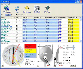
SatHunter is a program for calculating the orientation of a Satellite antenna. SatHunter contains all the necessary information for adjusting the Satellite antenna to the selected Satellite. The adjustment is made with the help of available tools (a compass or a protractor, a plumb, a tape measure) and requires neither expensive equipment nor deep knowledge about...
Category: Home & Education / Astrology & Numerology
Publisher: Protectedsoft Ltd., License: Shareware, Price: USD $29.95, File Size: 5.4 MB
Platform: Windows
OCENS MetMapper transforms weather maps, Satellite images, and ocean charts, into dynamic components of your at-sea decision-making tool box. MetMapper offers to all non-GRIB data what our GRIB Explorer software does for the GRIB data. That is, it will take classical weather data such as weather charts, ocean charts and Satellite imagery and render them into interactive elements...
Category: Home & Education / Miscellaneous
Publisher: OCENS, Inc., License: Shareware, Price: USD $169.00, File Size: 23.6 MB
Platform: Windows
Chart Trainer -Learn to read nautical charts like an expert.
Chart Trainer -Learn to read nautical charts like an expert.
Chart Trainer is designed to help mariners interpret nautical charts and use them more efficiently, both traditional paper charts and new digital charts for computers. The materials cover all aspects of nautical charts in the most detail available, including tutorials on Chart reading and plotting, along...
Category: Home & Education / Teaching Tools
Publisher: Starpath School of Navigation, License: Shareware, Price: USD $39.00, File Size: 39.8 MB
Platform: Windows
The Orbit Visualization Tool (OVT) is a software for visualization of Satellite orbits in the Earth's magnetic field. The program can display Satellite orbits in five coordinate systems (GEI, GEO, GSM, SMC, GSE), Satellite footprints projected on the Earth's surface and shown in either geographic (GEO) or geomagnetic (SMC) coordinates. In addition to...
Category: Home & Education / Astrology & Numerology
Publisher: OVT Team, License: Freeware, Price: USD $0.00, File Size: 0
Platform: Windows
KG-Chart for Cross Stitch" is a program to design a chart for cross stitching.
KG-Chart for Cross Stitch" is a program to design a Chart for cross stitching.
The ability to draw each stitch with a color and mark makes it easier for users to create a pattern for cross stitching. Usual painting software can't do this.
With this program you can print a Chart and a color table in which pages are automatically divided.
It also...
Category: Software Development / Help File Utilities
Publisher: Mozusystems, LLC, License: Shareware, Price: USD $0.00, File Size: 1.2 MB
Platform: Windows
Freeware
DreamBoxTools - a program for tuning your DreamBox Satellite receiver. Control your receiver right from the computer. Main features: - Lyngsat-to-Dreambox transponders parser. Update data about satellites and transponders to your receiver directly from the site Lyngsat.com - Satellite filter - Europe, Asia, Atlantic, America, only HD, manual choice, saved...
Category: DVD & Video / Video Conversion
Publisher: Protectedsoft Ltd., License: Freeware, Price: USD $0.00, File Size: 1014.4 KB
Platform: Windows
KG-Chart for Cross Stitch" is a program to design a chart for cross stitching.
KG-Chart for Cross Stitch" is a program to design a Chart for cross stitching. This program has following features:
* Drawing pixels with mark to distinguish color.
* Color palette (mimic DMC's thread color).
* Drawing backstitching
* Print/Preview/Real view of a Chart.
* Import/Export a Chart to/from other image...
Category: Multimedia & Design / Multimedia App's
Publisher: Keiji Ikuta Software Laboratory, License: Freeware, Price: USD $0.00, File Size: 1.1 MB
Platform: Windows
Satellite Finder is a way to accurately point satellite dishes at communications satellites in geostationary orbit.
Category: Home & Education / Mathematics
Publisher: arachnoid.com, License: Freeware, Price: USD $0.00, File Size: 1.4 MB
Platform: Windows, Mac, 2K
This program will enable you to display data in the colored 3D chart.
This program will enable you to display data in the colored 3D Chart. The program uses the 3D graphics library to display data in the 3D Chart.
Main Features
- Easy import of data from the TXT file.
- Fast 3D graphics.
- Colored scale.
- All properties of the Chart can be edited.
- Increasing data density using a filter...
Category: Multimedia & Design / Image Editing
Publisher: Michal Pohanka, License: Freeware, Price: USD $0.00, File Size: 1.4 MB
Platform: Windows
The Chart! is a software developed by DescriptMED that offers you an easy access to the charts of your patient when you don't have access to the daily Chart of the patient. This software allows doctors to gain very valuable time and to get the proper information very fast , no matter where they when they are searched
Category: Business & Finance / Business Finance
Publisher: DescriptMED, LLC, License: Shareware, Price: USD $2500.00, File Size: 35.9 MB
Platform: Windows
TerraClient allows viewing and printing of ground level satellite photographs of the United States.
TerraClient allows viewing and printing of ground level Satellite photographs of the United States. Featured is a unique map overlay option that automatically superimposes a "paper" roadmap over the Satellite photos. This map overlay option has been designed to help users identify indistinct land features in the Satellite photos. All map and photographic data is...
Category: Home & Education / Miscellaneous
Publisher: Bill Friedrich Software, License: Freeware, Price: USD $0.00, File Size: 1.3 MB
Platform: Windows