Free Downloads: Satellite Covert Tracking
Whether you need accurate data for GIS applications or visual simulation applications, GeoGenesis provides you the ability to exploit commercial Satellite or aerial imagery to meet your requirements. For aerial or Satellite imagery, GeoGenesis provides advanced automated tie point extraction to geospatially link multiple images together. Using our bundle adjustment algorithm you...
Category: Home & Education / Miscellaneous
Publisher: IAVO Research And Scientific, License: Freeware, Price: USD $0.00, File Size: 73.9 MB
Platform: Windows
 Shareware
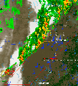
WeatherStudio combines a vast array of live weather data, products, maps, and charts into a single map that the user can pan and zoom. GFS/NDFD/NAM/RUC Model Data, Placefiles, Radar Loops, Satellite, Storm Reports, Hurricane Paths, Surface Observations, Watches/Warnings, Buoys, Shapefiles, GPS support, FTP Uploading, etc. Made for Storm Chasers, Mariners, Meteorologists, yet simple...
Category: Home & Education / Hobbies
Publisher: PaulMarv Software, License: Shareware, Price: USD $80.00, File Size: 13.0 MB
Platform: Windows
This is a very easy to use desktop application that will alert you whenever new articles are added to Portable Satellite Radio.com. Simply install the software and any time new content is added to the website, you will receive an alert on your desktop letting you know, and showing you part of the article. If you are interested and want to read the rest of the article, simply click on the...
Category: Desktop Enhancements / Misc. Themes
Publisher: Portable Satellite Radio, License: Freeware, Price: USD $0.00, File Size: 656.0 KB
Platform: Windows
Google Satellite SuperGet is a cute tool that help you to get small tile Satellite images from google maps. All downloaded small images are saved on the disk. You can view downloaded maps by offline,you can export them into a big images or tile images. You can easily get the longitude and latitude of each exported images.
Category: Home & Education / Miscellaneous
Publisher: Arceyes, License: Shareware, Price: USD $0.00, File Size: 3.4 MB
Platform: Windows
Satellite Free VST is a free and exclusive VST/AU/RTAS Plug-In Instrument.
Satellite Free VST is a free and exclusive VST/AU/RTAS Plug-In Instrument. It's multi-timbral, has great filters, effects and a built-in mixer.
Use it in your DAW (Logic, Cubase,Pro Tools, Live, etc) to play the sounds you downloaded.
It's easy to download and simple to install.
Category: Audio / Music Creation
Publisher: Samplebase, License: Freeware, Price: USD $0.00, File Size: 1.1 MB
Platform: Windows

Dish Network Discounts. Dish Network TV Deals! Dish Network Television Deals and Free Offers! DISH Network installation and service nationwide. Satellite TV systems from Profressional Dealers. Free Dishnet receivers and DVR systems. Satelite Television, DISH, Digital TV, Broadband Internet, HD and DirectTV free satlite deals available. Order for free satalite installation. Dish Network...
Category: Internet / Browsers
Publisher: Dish Network Discounts, License: Freeware, Price: USD $0.00, File Size: 1.5 MB
Platform: Windows
World Wind lets you zoom from satellite altitude into any place on Earth.
World Wind lets you zoom from Satellite altitude into any place on Earth. Leveraging Landsat Satellite imagery and Shuttle Radar Topography Mission data, World Wind lets you experience Earth terrain in visually rich 3D, just as if you were really there. V
Category: Home & Education / Mathematics
Publisher: worldwind.arc.nasa.gov, License: Freeware, Price: USD $0.00, File Size: 16.0 MB
Platform: Windows
CSCTool is a utility to covert between various (A)YUV and (A)RGB formats.
CSCTool is a utility to Covert between various (A)YUV and (A)RGB formats. Its written in C and Qt. Open Source software is licensed so you can download and use the software free-of-charge.
The source code for this software is made available free-of-charge, you (or a programmer you hire) can make changes to this software to better meet your needs, and you can release your...
Category: Utilities / Misc. Utilities
Publisher: Pfister GmbH, License: Freeware, Price: USD $0.00, File Size: 1.7 MB
Platform: Windows
TriVU-P is a free application allowing the user to easily control JAVAD GNSS receivers, i.
TriVU-P is a free application allowing the user to easily control JAVAD GNSS receivers, i.e. allowing efficiently managing receiver parameters and commands via a user friendly graphical interface.
With TriVU-P you can connect to the receiver directly, using any one of the following interfaces: serial, USB, TCP/IP (through the Ethernet ports or Wi-Fi adapter), or remotedly, via the...
Category: Internet / Communications
Publisher: JAVAD GNSS, License: Freeware, Price: USD $0.00, File Size: 14.9 MB
Platform: Windows
Prog Finder was designed to help users conveniently adjust their Terristeral antenna and Satellite dish.
This program is designed simply enough. Even a novice can easily understand how to modify its options. The interface is user-friendly, and the main buttons are organized in such a manner, as to easily guide you through the entire configuration process. Furthermore, this...
Category: Business & Finance / Applications
Publisher: ProgDVB, License: Freeware, Price: USD $0.00, File Size: 6.4 MB
Platform: Windows
SATBUSTER for Windows is especially designed for satellite visual observers and trackers.
SATBUSTER for Windows is especially designed for Satellite visual observers and trackers. Its users, mainly amateur astronomers, radio amateurs and Satellite trackers, appreciate both the accuracy and the simple to use graphical interface. The software is aimed to hobbysts. However a growing number of plain folks are starting to use this tool to recognize and look at the...
Category: Internet / Misc. Plugins
Publisher: PC, License: Freeware, Price: USD $0.00, File Size: 6.0 MB
Platform: Windows
Dynamsoft Issue Tracking Anywhere is a web based issue Tracking system designed for issue/work item Tracking, bug Tracking, customer support and project management. Issue Tracking Anywhere has two editions: Standalone and Hosted. Issue Tracking Anywhere Standalone can be downloaded and installed on your site. Issue Tracking Anywhere Hosted...
Category: Software Development / Debugging
Publisher: Dynamsoft, License: Freeware, Price: USD $0.00, CAD60, File Size: 39.0 KB
Platform: Windows, Other
This free reader detects and reads covert digital watermarks created through Digimarc for Images.
This free reader detects and reads Covert digital watermarks created through Digimarc for Images. Directly view information associated with digitally watermarked images through Internet Explorer and Windows Explorer, or use it to validate that your images are properly watermarked.
Compatible File Formats: BMP, JPG, TIFF, PNG and PSD.
Category: Multimedia & Design / Multimedia App's
Publisher: Digimarc, License: Freeware, Price: USD $0.00, File Size: 9.4 MB
Platform: Windows
Download the new version of Google Earth satellite with Google Pack.
Download the new version of Google Earth Satellite with Google Pack.Google pack includes 13 totally free software selected by google for your better internet experience.Software included in google pack - Google Earth,Norton Security Scan,Google Desktop,Google Toolbar for Internet Explorer,Spyware Doctor Starter Edition,Picasa photo editor,Mozilla Firefox internet browser,Google Talk,word...
Category: Home & Education / Science
Publisher: www.satelliteimage-of-my-house.com, License: Freeware, Price: USD $0.00, File Size: 589.0 KB
Platform: Windows
Orbcomm is a satellite communication system (www.
Orbcomm is a Satellite communication system (www.orbcomm.com) providing two-way data and positioning service to small, portable user terminals in the VHF frequency bands. You can use a simple VHF radio receiver (scanner) tuned to the band between 137 and 138 MHz to pick up the strong signals from these satellites. With OrbcommPlotter you can decode the telemetry and find out the...
Category: Home & Education / Miscellaneous
Publisher: COAA, License: Demo, Price: USD $0.00, File Size: 730.0 KB
Platform: Windows
ARISSatTLM is the telemetry software for the ARISSat-1 satellite.
ARISSatTLM is the telemetry software for the ARISSat-1 Satellite. You just need to open a decode a WAVE file, and, after that, you can start the soundcard.
It is easy to install and has a simple interface. It can be manipulated easily by everyone who have some knowledges in this domain.
Category: Utilities / Misc. Utilities
Publisher: ARISSatTLM, License: Freeware, Price: USD $0.00, File Size: 1.0 MB
Platform: Windows
Satellite Forms is an ideal tool for business and enterprise developers looking to build custom mobile applications, or to transform processes typically performed on paper to an electronic format for improved productivity and efficiency. Satellite Forms allows you to create usable, real-world applications without writing a single line of code. Even more sophisticated applications...
Category: Business & Finance / Project Management
Publisher: Thacker Network Technologies Inc., License: Shareware, Price: USD $0.00, File Size: 0
Platform: Windows
Earth Orbit Objects is free program which predict Satellite passes for your local or any selected area. Use flat Earth view to display Satellite tracks with visibility circle.
The globe view shows selected satellites around the Earth as a sphere and sky view shows satellites as you would see them in a starry night. The line elements are processed using SGP4 and SDP4...
Category: Home & Education / Miscellaneous
Publisher: Bluewing Trg, License: Freeware, Price: USD $0.00, File Size: 1.6 MB
Platform: Windows
WinPilot 3D is flight analysis and planning software, that lets you zoom in from Satellite altitude into any place on Earth, leveraging Landsat Satellite imagery and Shuttle Radar Topography Mission elevation data. WinPilot 3D lets you experience Earth terrain in visually rich 3D, just as if you were really there. WinPilot 3D also shows airspace in 3D, and contains world-wide...
Category: Home & Education / Miscellaneous
Publisher: WinPilot, License: Shareware, Price: USD $59.00, File Size: 3.8 MB
Platform: Windows
Flash2X EXE Packager is a program to covert flash to EXE files.
Flash2X EXE Packager is a program to Covert flash to EXE files. It supports both flash (SWF) and flash video (FLV) formats. You can customize your flash executable files to playback your flash and flash videos in the best way, and protect them from being used. Flash2X EXE Packager allows you to create executable files with a trail period and unlock code, so you can sell your files as...
Category: Multimedia & Design / Media Management
Publisher: Flash2X, License: Shareware, Price: USD $29.95, File Size: 1.1 MB
Platform: Windows
StratosNet Accelerator can reduce your standard IP access Satellite communications costs on FleetBroadband, BGAN and SwiftBroadband by up to 90%!
With StratosNet Accelerator, sending and receiving email, downloading files via FTP and browsing the internet via Satellite is faster and more cost effective than ever before. StratosNet Accelerator optimizes your IP connection by...
Category: Internet / Misc. Plugins
Publisher: Stratos Global, License: Freeware, Price: USD $0.00, File Size: 5.9 MB
Platform: Windows
Freeware
Get connected to your favorite videos and movies instantly and watch Satellite TV videos and movies at any time for free. - Convenient one click access - Easy access to your favorite TV & Movies - HD TV & PC *1080w - Windows 98, 2000, XP, Vista & 7 compatible - Mac compatible ( running windows )
Category: Multimedia & Design / Video
Publisher: Ruzey, License: Freeware, Price: USD $0.00, File Size: 524.9 KB
Platform: Windows
When you are looking for a powerful tool to satisfy various needs regarding vectors, raster and Satellite imagery, you will find ILWIS Academic an efficient application. The program comes with such useful features as points to create maps, lines for segment maps, closed area segments for polygon maps, spatial operations for raster maps and so on. Whilst using images from Satellite...
Category: Home & Education / Miscellaneous
Publisher: ITC, License: Freeware, Price: USD $0.00, File Size: 19.4 MB
Platform: Unknown
Sat-Coord is a software suite which assists in the processing of Satellite network information filed with the ITU, frequency overlap analysis and C/I calculation.
The software has undergone significant testing and development over a period of more than seven years and have been used extensively to support the Satellite coordination activities of RPC Telecom's...
Category: Internet / Misc. Plugins
Publisher: RPC Telecommunications Limited, License: Shareware, Price: USD $199.00, File Size: 19.0 MB
Platform: Windows
Korti is a Google Earth plugin which allows you to see the unique 3D Satellite map of Korti within your Google Earth application.
Korti provides you a detailed Satellite imagery and geographic information about this geographic place.
To have Korti installed on your PC, first install for free Google Earth and then Korti 3D map plugin. After that, simply double click...
Category: Multimedia & Design / Multimedia App's
Publisher: Maplandia, License: Freeware, Price: USD $0.00, File Size: 309 B
Platform: Windows