Free Downloads: Satellite Orbit Software
 Shareware
Google Satellite Maps Downloader is a cute tool that can automatically download Google Maps Satellite tile images and then combine them into one big map image. It supports multithreads, so the download speed is very fast. And it is very easy to use. All downloaded small images are saved on the disk. You can combine them after downloading or later. Isn't it very cool that you make...
Category: Internet / Download Managers
Publisher: allmapsoft.com, License: Shareware, Price: USD $39.00, File Size: 30.6 MB
Platform: Windows

Ready to start saving? It's never been a better time to switch to Satellite Television then now. You won't find better Dish Network deals available any where else on the internet.
If you've been throwing away your money on cable tv or DirecTV then you've come to the right place.
Order now
Save with special web only promotions! We are a high volume Satellite tv system...
Category: Internet / Browsers
Publisher: Dish Network Channel Packages, License: Freeware, Price: USD $0.00, File Size: 1.6 MB
Platform: Windows, Linux, Mac
Shareware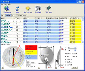
SatHunter is a program for calculating the orientation of a Satellite antenna. SatHunter contains all the necessary information for adjusting the Satellite antenna to the selected Satellite. The adjustment is made with the help of available tools (a compass or a protractor, a plumb, a tape measure) and requires neither expensive equipment nor deep knowledge about...
Category: Home & Education / Astrology & Numerology
Publisher: Protectedsoft Ltd., License: Shareware, Price: USD $29.95, File Size: 5.4 MB
Platform: Windows
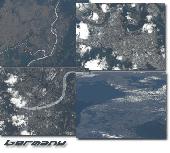
Protect your monitor with satellite-eye views of different parts of Germany.
Protect your monitor with Satellite-eye views of different parts of Germany.See pictures of Berlin, Munich, Cologne, Koblenz Area, Rhein River, Mosel River, Kiel, Frankfurt am Main, Wiesbaden, Mainz, Leipzig, Cottbus, Darmstadt, Duisburg, Hamburg, Karlsruhe, Kassel, Speyer and many more.This 32-bit screen-saver engine rotates photos of different locations of Germany as seen on clear days...
Category: Desktop Enhancements / Screensavers
Publisher: Tazmaniacs Screen Savers, License: Shareware, Price: USD $9.95, File Size: 3.3 MB
Platform: Windows
The Microdrone Airborne Mapping extension to Orbit GIS provides the tools required for automated flight and high precision mapping. It contains a Waypoint Generator, a Microdrone in-flight tracker, and a captation tool. Further image-, stereoprocessing and orthorectification can be executed using the Strabo Photogrammetry extension to Orbit GIS.
Category: Multimedia & Design / Multimedia App's
Publisher: Orbit GeoSpatial Technologies, License: Freeware, Price: USD $0.00, File Size: 30.0 MB
Platform: Windows
A simple screen saver with a Sputnik cruising space.
A simple screen saver with a Sputnik cruising space. Not in Orbit of Earth (as a real Satellite would be), but who cares? :)
Category: Desktop Enhancements / Screensavers
Publisher: Desktop-Backgrounds.net, License: Freeware, Price: USD $0.00, File Size: 624.6 KB
Platform: Windows
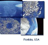
Protect your monitor with satellite-eye views of different parts of Florida, USA.
Protect your monitor with Satellite-eye views of different parts of Florida, USA.See pictures of Apalachicola Basin, West Florida, Cape Canaveral, Cape Coral, Fort Myers, Cape San Blas, the East Coast, Florida Keys, Florida Panhandle, Florida Peninsula, Greater Miami Area, Homestead, Jacksonville, Lake Okeechobee, Lakeland Area, Orlando, Panama City, Pensacola, Saint Joseph Bay, Tampa...
Category: Desktop Enhancements / Screensavers
Publisher: Tazmaniacs, License: Shareware, Price: USD $9.95, File Size: 2.9 MB
Platform: Windows
This is a very easy to use desktop application that will alert you whenever new articles are added to Portable Satellite Radio.com. Simply install the Software and any time new content is added to the website, you will receive an alert on your desktop letting you know, and showing you part of the article. If you are interested and want to read the rest of the article, simply click...
Category: Desktop Enhancements / Misc. Themes
Publisher: Portable Satellite Radio, License: Freeware, Price: USD $0.00, File Size: 656.0 KB
Platform: Windows

Protect your monitor with satellite-eye views of different parts of Florida, USA.
Protect your monitor with Satellite-eye views of different parts of Florida, USA. See pictures of Apalachicola Basin, West Florida, Cape Canaveral, Cape Coral, Fort Myers, Cape San Blas, the East Coast, Florida Keys, Florida Panhandle, Florida Peninsula, Greater Miami Area, Homestead, Jacksonville, Lake Okeechobee, Lakeland Area, Orlando, Panama City, Pensacola, Saint Joseph Bay, Tampa...
Category: Desktop Enhancements / Screensavers
Publisher: Tazmaniacs Screen Savers, License: Shareware, Price: USD $9.95, File Size: 1.9 MB
Platform: Windows
Freeware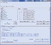
DreamBoxTools - a program for tuning your DreamBox Satellite receiver. Control your receiver right from the computer. Main features: - Lyngsat-to-Dreambox transponders parser. Update data about satellites and transponders to your receiver directly from the site Lyngsat.com - Satellite filter - Europe, Asia, Atlantic, America, only HD, manual choice, saved...
Category: DVD & Video / Video Conversion
Publisher: Protectedsoft Ltd., License: Freeware, Price: USD $0.00, File Size: 1014.4 KB
Platform: Windows
TerraClient allows viewing and printing of ground level satellite photographs of the United States.
TerraClient allows viewing and printing of ground level Satellite photographs of the United States. Featured is a unique map overlay option that automatically superimposes a "paper" roadmap over the Satellite photos. This map overlay option has been designed to help users identify indistinct land features in the Satellite photos. All map and photographic data is...
Category: Home & Education / Miscellaneous
Publisher: Bill Friedrich Software, License: Freeware, Price: USD $0.00, File Size: 1.3 MB
Platform: Windows
DESA Satellite Tracker allows you to track the International Space Station and other satellites in real time. The built in radar alarm will alert you to satellites that would be visible to you and let you know where to look (although you will only be able to actually see the satellites an hour before sunrise and an hour after sunset).
DESA Satellite Tracker is 100% free
Category: Home & Education / Astrology & Numerology
Publisher: red diligence, License: Freeware, Price: USD $0.00, File Size: 977.8 KB
Platform: Windows
Whether you need accurate data for GIS applications or visual simulation applications, GeoGenesis provides you the ability to exploit commercial Satellite or aerial imagery to meet your requirements. For aerial or Satellite imagery, GeoGenesis provides advanced automated tie point extraction to geospatially link multiple images together. Using our bundle adjustment algorithm you...
Category: Home & Education / Miscellaneous
Publisher: IAVO Research And Scientific, License: Freeware, Price: USD $0.00, File Size: 73.9 MB
Platform: Windows
Download the new version of Google Earth satellite with Google Pack.
Download the new version of Google Earth Satellite with Google Pack.Google pack includes 13 totally free Software selected by google for your better internet experience.Software included in google pack - Google Earth,Norton Security Scan,Google Desktop,Google Toolbar for Internet Explorer,Spyware Doctor Starter Edition,Picasa photo editor,Mozilla Firefox internet...
Category: Home & Education / Science
Publisher: www.satelliteimage-of-my-house.com, License: Freeware, Price: USD $0.00, File Size: 589.0 KB
Platform: Windows
ARISSatTLM is the telemetry software for the ARISSat-1 satellite.
ARISSatTLM is the telemetry Software for the ARISSat-1 Satellite. You just need to open a decode a WAVE file, and, after that, you can start the soundcard.
It is easy to install and has a simple interface. It can be manipulated easily by everyone who have some knowledges in this domain.
Category: Utilities / Misc. Utilities
Publisher: ARISSatTLM, License: Freeware, Price: USD $0.00, File Size: 1.0 MB
Platform: Windows
SATBUSTER for Windows is especially designed for satellite visual observers and trackers.
SATBUSTER for Windows is especially designed for Satellite visual observers and trackers. Its users, mainly amateur astronomers, radio amateurs and Satellite trackers, appreciate both the accuracy and the simple to use graphical interface. The Software is aimed to hobbysts. However a growing number of plain folks are starting to use this tool to recognize and look at the...
Category: Internet / Misc. Plugins
Publisher: PC, License: Freeware, Price: USD $0.00, File Size: 6.0 MB
Platform: Windows
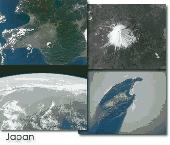
Protect your monitor with satellite-eye views of different parts of Japan.
Protect your monitor with Satellite-eye views of different parts of Japan.See pictures of Akita Area, Honshu, Coastal Plains, Hokkaido Island, Eastern Hokkaido Island, Fukuoka, Kyushu, Futago Mountain, Kyushu, Hiroshima Area, Honshu, Inland Sea, Iriomote Island, Ryukyu Islands, Ishigaki Island, Kitakyushu, Kyushu, Kobe and Osaka, Miyako and Irabu Islands, Mount Aso Volcano, Kyushu, Mount...
Category: Desktop Enhancements / Screensavers
Publisher: Tazmaniacs Screen Savers, License: Shareware, Price: USD $9.95, File Size: 3.1 MB
Platform: Windows
Google Satellite SuperGet is a cute tool that help you to get small tile Satellite images from google maps. All downloaded small images are saved on the disk. You can view downloaded maps by offline,you can export them into a big images or tile images. You can easily get the longitude and latitude of each exported images.
Category: Home & Education / Miscellaneous
Publisher: Arceyes, License: Shareware, Price: USD $0.00, File Size: 3.4 MB
Platform: Windows
Satellite Free VST is a free and exclusive VST/AU/RTAS Plug-In Instrument.
Satellite Free VST is a free and exclusive VST/AU/RTAS Plug-In Instrument. It's multi-timbral, has great filters, effects and a built-in mixer.
Use it in your DAW (Logic, Cubase,Pro Tools, Live, etc) to play the sounds you downloaded.
It's easy to download and simple to install.
Category: Audio / Music Creation
Publisher: Samplebase, License: Freeware, Price: USD $0.00, File Size: 1.1 MB
Platform: Windows

Dish Network Discounts. Dish Network TV Deals! Dish Network Television Deals and Free Offers! DISH Network installation and service nationwide. Satellite TV systems from Profressional Dealers. Free Dishnet receivers and DVR systems. Satelite Television, DISH, Digital TV, Broadband Internet, HD and DirectTV free satlite deals available. Order for free satalite installation. Dish Network...
Category: Internet / Browsers
Publisher: Dish Network Discounts, License: Freeware, Price: USD $0.00, File Size: 1.5 MB
Platform: Windows
World Wind lets you zoom from satellite altitude into any place on Earth.
World Wind lets you zoom from Satellite altitude into any place on Earth. Leveraging Landsat Satellite imagery and Shuttle Radar Topography Mission data, World Wind lets you experience Earth terrain in visually rich 3D, just as if you were really there. V
Category: Home & Education / Mathematics
Publisher: worldwind.arc.nasa.gov, License: Freeware, Price: USD $0.00, File Size: 16.0 MB
Platform: Windows
WinPilot 3D is flight analysis and planning Software, that lets you zoom in from Satellite altitude into any place on Earth, leveraging Landsat Satellite imagery and Shuttle Radar Topography Mission elevation data. WinPilot 3D lets you experience Earth terrain in visually rich 3D, just as if you were really there. WinPilot 3D also shows airspace in 3D, and contains...
Category: Home & Education / Miscellaneous
Publisher: WinPilot, License: Shareware, Price: USD $59.00, File Size: 3.8 MB
Platform: Windows
Dark Orbit 1.0.0.0 is a free browser based space shooting game.
"Browser based" means that you won´t have to download anything to your PC. I´ve provided a download link and a 1 byte file size to please the interface, but you don´t have to download anything.
Just entering in http://us1.darkorbit.com you´re ready to begin playing....
Category: Games / Misc. Games
Publisher: BigPoint, License: Freeware, Price: USD $0.00, File Size: 0
Platform: Windows
Sat-Coord is a Software suite which assists in the processing of Satellite network information filed with the ITU, frequency overlap analysis and C/I calculation.
The Software has undergone significant testing and development over a period of more than seven years and have been used extensively to support the Satellite coordination activities of RPC...
Category: Internet / Misc. Plugins
Publisher: RPC Telecommunications Limited, License: Shareware, Price: USD $199.00, File Size: 19.0 MB
Platform: Windows
Prog Finder was designed to help users conveniently adjust their Terristeral antenna and Satellite dish.
This program is designed simply enough. Even a novice can easily understand how to modify its options. The interface is user-friendly, and the main buttons are organized in such a manner, as to easily guide you through the entire configuration process. Furthermore, this...
Category: Business & Finance / Applications
Publisher: ProgDVB, License: Freeware, Price: USD $0.00, File Size: 6.4 MB
Platform: Windows