Free Downloads: Software State Country Maps
 Shareware
FPS Maps for WPF is a brand new component with a set of built-in Country Maps. There are 15 Inbuilt Countries. FPS Maps for WPF contains samples of how to work with it and customize. Maps navigation can be performed via Navigation bar which supports Themes and mouse. You can pan with mouse or zoom in/out with mouse scroll. More options will be added in...
Category: Software Development / Components & Libraries
Publisher: FPS Components, License: Shareware, Price: USD $199.00, File Size: 1.1 MB
Platform: Windows
LAN state monitoring software maps graphically, status of remote network.
LAN State monitoring Software Maps graphically, status of remote network. Utility have the functionality of host-monitoring, which allows you to maintain tracks of desktop LAN systems network at any instant of time. Application Software allows system administrator to access, manage, retrieve and keeps track of network devices easily. Utility responds monitoring...
Category: Internet / Remote Access
Publisher: Data Recovery Reviews, License: Shareware, Price: USD $49.95, File Size: 125.0 KB
Platform: Windows
Single State Mapping Tool allows you to create Maps of individual states with Microsoft® MapPoint® 2002, 2004 or 2006. Make Maps of individual states. For various purposes, many users of Microsoft MapPoint would like to cover up neighboring states for their Maps in Microsoft MapPoint. This tool allows you to do that. Demo data file allows you to create an...
Category: Business & Finance
Publisher: MP2KMag and Winwaed Software Technology LLC, License: Data Only, Price: USD $75.00, File Size: 1.4 MB
Platform: Windows

Commercial realtors require accurate and reliable tools to publish available properties online and show them on the website (specifying region, county, State, and city). We have created a unique Interactive Real Estate Map with all USA states and counties on it for real estate business. USA Real Estate Map is a unique and amazing vector-based tool that is very simple to use. We...
Category: Internet
Publisher: USFlashMap.com, License: Shareware, Price: USD $399.00, File Size: 3.9 MB
Platform: Windows, Mac, Linux, Unix, MS-DOS, AS/400, OS/2
From climbing the Empire State Building to skating in Central Park - the 10 best of everything to see, buy, do, taste and avoid in New York, plus New York Maps and metro Maps.
Discover the most amazing skyscrapers, liveliest bars and lounges, best shows and live music venues, most unmissable museums and galleries, hottest shopping districts, most fun places for kids,...
Category: Internet / Communications
Publisher: Mobile Systems, License: Shareware, Price: USD $9.80, File Size: 0
Platform: Windows
Freeware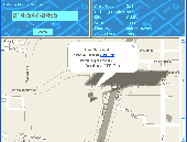
Find out the geographical location of any US or Canada phone number. Just type in any phone number and we'll tell you which city, State, and Country the phone is located in. We'll also give all the possible zip codes that are located in the area. The Software also shows you where the phone number resides using Google Maps. Our phone number tracer program is Free....
Category: Audio / MP3 Search Tools
Publisher: Phone Number Tracer, License: Freeware, Price: USD $0.00, File Size: 10.6 MB
Platform: Windows, Other
Shareware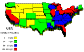
PolyMap is a desktop mapping program that lets you use your own data to customize the Maps supplied with the program. Use the built-in spreadsheet to enter data or paste it from other Windows applications. Alternatively, you can use the import feature to bring in data from external spreadsheets, text, or database files. The Map Presentation Wizard gives you a step-by-step process to...
Category: Web Authoring / Site Mapping Tools
Publisher: Ambiente Informatica Ltda, License: Shareware, Price: USD $89.95, BRL389, File Size: 7.4 MB
Platform: Windows
Freeware
This free radio player lets you access internet only Country music radio stations, FM land radio stations. Plus, access Country music MP3's, torrents, Country music news, and Country music videos. Also, has weather widget and email notifier. Listen lots of great Country stations like 181.fm - Kickin Country, 181.fm - Highway 181, 95.3 KRTY, 97.1 KTHT,...
Category: Audio / Audio Players
Publisher: Country Internet Radio, License: Freeware, Price: USD $0.00, File Size: 1.5 MB
Platform: Windows

FSS Google Maps Downloader is a tool that can download the Google Maps images to your PC. This is a clearly free program. There is no spyware or adware. It's absolutely safe to install and to run. The interface is very simple and self explaining. It runs low on system resources consumption and is supported on all Windows versions. It can save them to your hard disk,...
Category: Internet / Download Managers
Publisher: FreeSmartSoft, License: Freeware, Price: USD $0.00, File Size: 874.0 KB
Platform: Windows
MapComp is a powerful and free Windows Software for drawing images of linkage Maps and to compare linkage Maps and indicate common markers.
MapInspect can display, print and save images, and has no limit to the number of Maps it can compare (but only neighbouring Maps are compared). Maps can be flipped within MapINspect, an the on-screen...
Category: Multimedia & Design / Multimedia App's
Publisher: MapInspect, License: Freeware, Price: USD $0.00, File Size: 616.7 KB
Platform: Windows
IP2Location(tm) IP-COUNTRY is commericial lookup database that translates IP address to country.
IP2Location(tm) IP-Country is commericial lookup database that translates IP address to Country. Developers use this database for projects related to:
1. Display native language and currency;
2. Redirect based on Country;
3. Digital rights management;
4. Prevent password sharing and abuse of service;
5. Reduce credit card fraud;
6. Web log stats and...
Category: Internet / News Applications
Publisher: IP2Location.com, License: Data Only, Price: USD $49.00, File Size: 200.0 KB
Platform: Windows, Linux, Mac, Palm
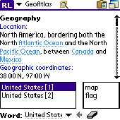
Learn more about countries in the World. Keep this atlas as the reference when you need geographical information such as Country location, neighbours, capital, population, economy, military and more including Country map and flag pictures. Whenever you solve a crossword puzzle, perform study research, watch TV news or just get interested in geography - this atlas helps you with...
Category: Home & Education
Publisher: AbsoluteWord, License: Shareware, Price: USD $19.95, File Size: 4.4 MB
Platform: Palm
Diffuse maps represent the absorption of light.
Diffuse Maps represent the absorption of light. Diffuse Maps are what people call "textures". They are the color textures or photographic textures usually applied to 3d models.
ShaderMap creates displacement Maps using the light data stored inside of diffuse Maps. Evenly lit diffuse Maps generally create better quality Maps with ShaderMap.
Category: Home & Education / Miscellaneous
Publisher: Rendering Systems Inc., License: Freeware, Price: USD $0.00, File Size: 4.0 MB
Platform: Windows
NOVA Maps provides appraisers and appraisal users with complete, high-resolution location Maps (also known as “street Maps”) for forms and addenda in seconds. NOVA Maps even automatically places labels for subject properties and comparables.
For just pennies per map and with just a click of the mouse, users have access to the entire United...
Category: Home & Education / Miscellaneous
Publisher: Day One, License: Demo, Price: USD $0.00, File Size: 5.7 MB
Platform: Windows
This Software development kit (SDK) provides the binaries and programming reference for the Bing Maps Silverlight Control. You can use this control to build your own web sites that use Bing Maps.
The Bing Maps Silverlight Control combines the power of Silverlight and Bing Maps to provide an enhanced mapping experience. Developers can use the Bing...
Category: Utilities / Misc. Utilities
Publisher: Microsoft, License: Freeware, Price: USD $0.00, File Size: 3.8 MB
Platform: Windows
Shareware
Google Hybrid Maps Downloader is a tool that can automatically download the google hybrid Maps images to your PC. It can download the small tiles and save them to your hard disk. After downloading, you can view the Maps offline by its tool Maps Viewer, or you can combine the small images into one big map image. If you want to make a map of your city by yourself, it...
Category: Internet / Download Managers
Publisher: allmapsoft.com, License: Shareware, Price: USD $29.99, File Size: 30.6 MB
Platform: Windows
Shareware
Google Maps Terrain Downloader is a tool that can automatically download the google terrain Maps images to your PC. It can download the small tiles and save them to your hard disk. After downloading, you can view the Maps offline by its tool Maps Viewer, or you can combine the small images into one big map image. If you want to make a map of your city by yourself, it...
Category: Internet / Download Managers
Publisher: allmapsoft.com, License: Shareware, Price: USD $29.99, File Size: 305.3 MB
Platform: Windows

You can think of the Tometa WhereIs service as the Internet's telephone directory. It gives you information on the geographical location of an IP address based on Internet infrastructure information With a free SDK, email support and code examples in almost any language WhereIs easily provides information on the geographic location of Internet visitors and IP addresses. Cutting edge IP...
Category: Internet
Publisher: Tometa Software, Inc., License: Shareware, Price: USD $9.95, File Size: 2.2 MB
Platform: Windows, Mac, Linux, Palm,
This is a great addition for all those people that really feel their love for their country.
This is a great addition for all those people that really feel their love for their Country. In particular, I am referring to America.
Independence Day Wallpaper by Wallery brings celebration to your screen.
This wallpaper will do several things on your everyday mood. It will not matter if you are tired, stressed, angry, happy or sad. If you are suddenly in one of those...
Category: Desktop Enhancements / Screensavers
Publisher: W3i, LLC, License: Freeware, Price: USD $0.00, File Size: 1.6 MB
Platform: Windows
SensAct -SENSORS CONVERSION Maps AND ACTUATORS COMMAND Maps
This Software pack contents the sensors conversion Maps and the actuators command Maps like motorized throttles, gasoline injectors corrections, ...
It is mandatory to install it to select the type of sensor and actuators that are equiping the ECUs, because these Maps are no longer...
Category: Business & Finance / Applications
Publisher: Skynam, License: Freeware, Price: USD $0.00, File Size: 3.4 MB
Platform: Windows
IP Country Lookup is a free DNS tool for Windows that lets you lookup the Country an IP address or hostname originates from. It uses a locally installed file containing a list of networks and associated countries to quickly determine the geographic source of an address. IP Country lookup is provided entirely free and is not a trial or crippled version of the application....
Category: Internet / Tools & Utilities
Publisher: SpamButcher Spam Email Filter Software, License: Freeware, Price: USD $0.00, File Size: 1.1 MB
Platform: Windows
CensusInfo is an innovative and flexible database technology for the dissemination of population and housing census results.
Main features:
- Census indicators organised by sector
- Country-specific adaptation for indicator lists
- Census data disaggregated by socio-economic characteristics
- Sub-national data linked to...
Category: Business & Finance / Database Management
Publisher: United Nations Statistics Division, License: Freeware, Price: USD $0.00, File Size: 167.0 MB
Platform: Windows
Free version of MaxMind's GeoIP Country database.
Free version of MaxMind's GeoIP Country database. Download the latest database updates from MaxMind's website. The GeoLite Country database has an estimated accuracy rating of 98% for determining the IP Country location. Should more accuracy or granularity be needed, please visit http://www.maxmind.com for information on MaxMind's GeoIP Country, GeoIP Region, GeoIP...
Category: Web Authoring / Web Design Utilities
Publisher: MaxMind, License: Freeware, Price: USD $0.00, File Size: 819.2 KB
Platform: Windows, Mac, Linux, Unix, 2 Wa
GeoLite Country is a free version of MaxMind's GeoIP Country database. The GeoLite Country database has an estimated accuracy rating of 97% for determining the location of IP addresses by Country and is a complete and functional database. Monthly updates available for free at MaxMind's website. Supported APIs can be found at www.maxmind.com and include: Apache, C, C#...
Category: Software Development
Publisher: MaxMind, License: Freeware, Price: USD $0.00, File Size: 814.5 KB
Platform: Windows, Mac, Linux, Unix, OS/2
think! Bubble Maps is a Windows tool for creating bubble Maps and capturing your thought. Using simple mouse click, drags and typing, your thoughts get put to paper (virtual), quickly and effectively.
The key feature of think! Bubble Maps is speed which makes it an excellent tool for live capture. You can use this program during meetings, workshops, and seminars.
Category: Multimedia & Design / Multimedia App's
Publisher: Lowrie Associates Ltd, License: Shareware, Price: USD $41.90, File Size: 5.9 MB
Platform: Windows