Free Downloads: Topography
 Shareware
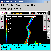
Simple, powerful and inexpensive CAD software for surveying. You can do triangulation, isolines, color-filled contour maps, sections, intersections, volume and much more. You can process hundreds of thousands of points or triangles, even on less powerful PCs. Through its own CAD system (called RCAD), specialized for 3D and for a large number of entities, you can: -load and draw a file of...
Category: Multimedia & Design / Graphics Viewers
Publisher: Rcad Software, License: Shareware, Price: USD $49.00, File Size: 1.0 MB
Platform: Windows

Importation/Exportation: Import/export trails to gpx file. Unlimited number of trails, and TrackPoints. Export to gpx, Excel, PDF, XPS and KML/KMZ. Data table: Very flexible data table that allows sorting by columns, with inheritance of data, attributes, etc. Presentation on map: View on map in accordance with the active trail, which comes from providers of maps, as in 'Satellite' mode...
Category: Home & Education / Miscellaneous
Publisher: Aplicaciones Topográficas S.L., License: Freeware, Price: USD $0.00, File Size: 27.0 MB
Platform: Windows
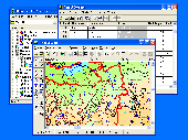
GIS ObjectLand is a universal Geographic Information System for Windows. Key features: - creation of vector-raster maps with arbitrary structure of layers and feature types; - creation of themes. Theme is a user presentation of a map; - control of displaying features depending on the chosen scale; - spatial data input and editing by assigning feature coordinates and also by interactive...
Category: Business & Finance
Publisher: Radom-T, License: Shareware, Price: USD $99.00, File Size: 24.0 MB
Platform: Windows
In areas where the geological structures are approximately two-dimensional (2D), conventional 2D electrical imaging surveys have been successfully used. The main limitation of such surveys is probably the assumption of a 2D structure. In areas with complex structures, there is no substitute for a fully 3D survey. This program is designed to invert data collected with a rectangular grid of...
Category: Multimedia & Design / Image Editing
Publisher: geoelectrical, License: Shareware, Price: USD $5100.00, File Size: 10.7 MB
Platform: Windows