Free Downloads: User Coordinate System
Archimedes Grapher is a kind of powerful and convenient tool software which supports functional graph plotting, numerical calculation, unit conversion, and slide show. It can plot all kinds of graphs (functional graphs, table graphs, polar equation, parameter equation, inequation and etc.), implement all kinds of calculations (multivariable scientific calculation, generating numerical table,...
Category: Home & Education / Miscellaneous
Publisher: NewXor Software,Inc, License: Shareware, Price: USD $28.00, File Size: 2.1 MB
Platform: Windows
JCapPM allows you to associate coordinate information (x/y) to each photo.
JCapPM allows you to associate Coordinate information (x/y) to each photo. JCapPM can communicate with Google Earth which allows you to geotag all your files using Google Earth. You can use JCapPM's filter in order to geotag only filtered photos at once.
Category: Home & Education / Miscellaneous
Publisher: ZeroG Software, License: Freeware, Price: USD $0.00, File Size: 2.5 MB
Platform: Windows
Design elements of this pack coordinate with the following products: Splendor Pack.
Design elements of this pack Coordinate with the following products: Splendor Pack. You may use graphic elements in layouts and other craft projects that are submitted to scrapbooking magazines for publication, online galleries, or other non-retail web communities, as long as proper credit is given to the designer by name, including credit
notice of any graphic you have altered in...
Category: Desktop Enhancements / Shell & Desktop Managers
Publisher: StoryRock Inc., License: Freeware, Price: USD $0.00, File Size: 23.5 MB
Platform: Windows
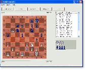
NetChess is a chess program that allows you to play with opponent over internet/intranet or on the local computer. You can load or save game. The built-in chat provides a quick and efficient solution to essential communication between players. This software will verify your moves according to chess rules. Features include chess-clock, move logging, Coordinate System, and much more.
Category: Games / Strategy & War
Publisher: RS Software Lab, License: Freeware, Price: USD $0.00, File Size: 344.0 KB
Platform: Unknown
ProLat DLL is a complete coordinate conversion toolkit for most programming languages and Excel.
ProLat DLL is a complete Coordinate conversion toolkit for most programming languages and Excel. Its ease-of-use and industry standard accuracy make it an ideal solution. ProLat DLL software requires one license for each developer work-station where it is used for development even if the software is installed on a server.
Category: Software Development / Misc. Programming
Publisher: Effective Objects, License: Shareware, Price: USD $250.00, File Size: 2.6 MB
Platform: Windows
GPS Sway is a simple coordinate conversion program.
GPS Sway is a simple Coordinate conversion program. It handles all forms of latitude and longitude (degrees, degrees minutes, degrees minutes seconds) as well as UTM coordinates and will convert from any form to another. It also handles signs or character direction.
Category: Multimedia & Design / Media Management
Publisher: GPSFileDepot, License: Freeware, Price: USD $0.00, File Size: 154.2 KB
Platform: Windows
 Shareware
TOPOWIN is a state-wide register of the German Topographic Cartographies, the German Basic Cartography and of localities with geo references in different Coordinate systems. It is also a topographic information System. In the division of planning and execution of economical and scientific projects frequently topographic documents are used. The program TOPOWIN makes information...
Category: Home & Education / Miscellaneous
Publisher: Killet GeoSoftware Ing.-GbR, License: Shareware, Price: USD $125.00, EUR110, File Size: 4.5 MB
Platform: Windows
COGO (COordinate GeOmetry) is an engineering tool used to determine geometric relationships.
COGO (Coordinate GeOmetry) is an engineering tool used to determine geometric relationships. There are a number of ways to create a geometric model. There is a command language that allows the User to define and solve geometric problems in engineering terms. There are Windows forms that you fill in to create the geometry. And you can execute COGO inside of AutoCAD using the...
Category: Multimedia & Design / Image Editing
Publisher: Colorado DOT, License: Freeware, Price: USD $0.00, File Size: 3.5 MB
Platform: Windows
Graphing Software without the Learning Curve
Whether graphing equations or making a Coordinate grid, HandyGraph helps you create attractive graphical images quickly.
This graphing program was designed for teaching math. We understand the work involved with teaching, and we created HandyGraph to make your job a bit easier. You can make accurate high-quality graph images...
Category: Business & Finance / MS Office Addons
Publisher: Del Rey, License: Shareware, Price: USD $59.00, File Size: 3.4 MB
Platform: Windows
Asymptote is a powerful descriptive vector graphics language that provides a natural Coordinate-based framework for technical drawing. Labels and equations are typeset with LaTeX, for high-quality PostScript output.
A major advantage of Asymptote over other graphics packages is that it is a programming language, as opposed to just a graphics program.
Category: Multimedia & Design / Multimedia App's
Publisher: Andy Hammerlindl, John Bowman, Tom Prince, License: Freeware, Price: USD $0.00, File Size: 3.5 MB
Platform: Windows
The fGIS Editor is a multi-purpose, full-featured, powerful, and easy-to-use GIS application.
The fGIS Editor is a multi-purpose, full-featured, powerful, and easy-to-use GIS application. Created by the same technical expertise behind the popular freeware fGIS program, the fGIS Editor provides a clear, supported upgrade path for current users of fGIS. The fGIS Editor is built upon the TatukGIS Editor and combines the familiar features found in fGIS with the new, powerful features found...
Category: Multimedia & Design / Multimedia App's
Publisher: TatukGIS Consulting, License: Shareware, Price: USD $99.00, File Size: 4.8 MB
Platform: Windows
SurvCE Application is a complete data collection System for Real Time (RTK) GPS and Total Stations with in-field Coordinate geometry SurvCE, which combines advanced functionality, ease-of-use and robust capability to make it the first choice in data collection software. This tool supports the widest range of popular Carlson SurvCE #1 Data Collection Software Choice and new release...
Category: Business & Finance / Database Management
Publisher: Carlson Software, License: Freeware, Price: USD $0.00, File Size: 3.5 MB
Platform: Windows
Adaptive Home Logic is an advanced, highly flexible, easy to use home automation / remote access application that can seamlessly Coordinate and control home lighting, HVAC, security and home theatre systems from your Windows computer. Includes full two-way support for X10 and the latest UPB power line modules, two-way prioritised speech System, TCP/IP client / server communication...
Category: Utilities / Misc. Utilities
Publisher: Acentient Software, License: Shareware, Price: USD $56.00, File Size: 31.7 MB
Platform: Windows
Adaptive Home Logic is an advanced, highly flexible, easy to use home automation / remote access application that can seamlessly Coordinate and control home lighting, HVAC, security and home theatre systems from your Windows XP computer. Version 2 includes full two-way support for X10 and the latest UPB power line modules, two-way prioritised speech System, TCP/IP client / server...
Category: Home & Education / Miscellaneous
Publisher: Acentient Software, License: Shareware, Price: USD $69.95, File Size: 31.7 MB
Platform: Windows
Rocanda Land Tracker software will allow you to convert any LSD location in Alberta, British Columbia, Saskatchewan or Manitoba into a corresponding latitude/longitude Coordinate. which you can then input into mapping software such as Garmin's Mapsource products, or OziExplorer.
Category: Business & Finance / MS Office Addons
Publisher: Rocanda, License: Shareware, Price: USD $179.00, File Size: 8.6 MB
Platform: Windows
The Grid InQuest software provides a means for transforming coordinates between ETRS89 (WGS84) and the National Coordinate systems of Great Britain, Northern Ireland and the Republic of Ireland. It provides a fully three dimensional transformation incorporating the latest geoid model and is the nationally recognised software for performing these conversions.
In conjunction...
Category: Home & Education / Miscellaneous
Publisher: Quest Geo Solutions Ltd, License: Freeware, Price: USD $0.00, File Size: 0
Platform: Windows
Shareware
GPS SDK to add GPS and Coordinate conversion functionality to your software and scripts). All NMEA0183 protocol versions are supported and can be filtered by NMEA sentence type and talker ID. Garmin USB PVT support. Information on GPS status can also be retrieved: GPS fix quality, satellites used in fix, satellites in view, satellite azimuth, elevation and signal strengths. The...
Category: Software Development
Publisher: Eye4Software B.V., License: Shareware, Price: USD $99.00, EUR79, File Size: 2.3 MB
Platform: Windows
This applet constructs quadrilaterals from the x and y Coordinate values of four given points, and also determines the category of the constructed quadrilateral (rectangle, square etc.).
Category: Home & Education / Mathematics
Publisher: eridanus.info, License: Freeware, Price: USD $0.00, File Size: 10.6 KB
Platform: Linux, Windows
PHOTOMOD GeoMosaic is intended for working with various types of digital images, including aerial and space imagery as well as digitized raster maps.
The program functionality includes:
- Georeferencing of raster images;
- Transforming images from one Coordinate System to another, using an extensive database supplied or custom created...
Category: Multimedia & Design / Multimedia App's
Publisher: Racurs, License: Freeware, Price: USD $0.00, File Size: 36.5 MB
Platform: Windows
Highly interactive tutorials and self-test System for individual e-learning, home schooling, college and high school computer learning centers, and distance learning. The product covers the standard topics of a one-year high school course preparing for Calculus, with the emphasis on building problem-solving skills. Tutorials include the reviews of basic concepts, interactive examples,...
Category: Home & Education / Mathematics
Publisher: MathAid, LLC, License: Demo, Price: USD $32.95, File Size: 665.6 KB
Platform: Windows, Linux, Unix
Shareware
Java toolkit to add Coordinate conversion functionality to your Java applications and applets. The toolkit offers functionality to perform map grid and datum transformations: latitude and longitude can be converted to various map grids, like Transverse Mercator (TM), Oblique Mercator, Mercator, Oblique Stereographic, Polar Stereographic, Cassini, Albers Equal Area Conal, Gauss Kruger or...
Category: Software Development / Components & Libraries
Publisher: Eye4Software B.V., License: Shareware, Price: USD $199.00, EUR179, File Size: 155.5 KB
Platform: Unknown
The Datgel Survey Tools gINT Add-In consists of a range of utilities for the processing and querying of 3D surfaces, alignments and tidal data.
1. Set Coordinate Chainage Offset Tool: Calculates the coordinates to/from chainage and offset based on alignment data.
2. Grid File Pre-processing Tool: Pre-processes surface files to produce perfect grids, slice up over sized...
Category: Business & Finance / Business Finance
Publisher: Datgel, License: Shareware, Price: USD $0.00, File Size: 0
Platform: Windows
Explain why and how a pinball shooter can be used to help understand ideas about reactions.
Explain why and how a pinball shooter can be used to help understand ideas about reactions.
Describe on a microscopic level what contributes to a successful reaction (with illustrations).
Describe how the reaction Coordinate can be used to predict whether a reaction will proceed or slow.
Use the potential energy diagram to determine: The activation energy for the...
Category: Home & Education / Science
Publisher: University of Colorado, Department of Physics, License: Freeware, Price: USD $0.00, File Size: 1.9 MB
Platform: Windows
CopanMobile for Palm OS is a very functional and easy-to-use geomatics engineering tool for computing and managing plane surveying and mapping coordinates. It does numerous Coordinate geometry (COGO) calculations, processes and adjusts raw field survey data, computes and adjusts map traverse data, performs map or deed checks, calculates curves, areas and perimeters, performs...
Category: Multimedia & Design / Multimedia App's
Publisher: Underhill Geomatics Ltd., License: Freeware, Price: USD $0.00, File Size: 341.0 KB
Platform: Palm
The Survey Import and Export program works with AutoCAD (dwg) and Coordinate data in formats such as txt, ascii, and csv. The configurable interface makes matching survey descriptions (as assigned in the field) to text, blocks (with attributes) or various point types, straightforward. SQL drives the included Survey.mdb to support the constuction and management of field book description...
Category: Multimedia & Design / Multimedia App's
Publisher: CADD Productivity, License: Shareware, Price: USD $119.00, File Size: 3.1 MB
Platform: Windows