Free Downloads: World Map Shp
Covering every month of every theatre of World War II, this huge atlas is for wargamers and anyone interested in World War II. It provides a highly interactive and thought-provoking view of the war, and is a great starting point for what-if scenarios. Each Map contains date, movement, unit strengths and other military details.
From the World overview you...
Category: Home & Education / Miscellaneous
Publisher: ProFantasy Software, License: Shareware, Price: USD $27.95, File Size: 57.0 MB
Platform: Windows
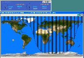
DXView presents a World Map, upon which beam headings, stations you spot, the sun's position, and the solar terminator are continuously displayed.This software displays real-time data on a World Map, displays boundary overlays for continents,ITU regions and much more
Category: Multimedia & Design / Multimedia App's
Publisher: DXLab, License: Freeware, Price: USD $0.00, File Size: 2.0 MB
Platform: Windows
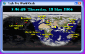
If you need to keep track of the time in different parts of the World, or want to find the international dialing code for another country, you need Tech-Pro World Clock 2. It's a Windows desktop accessory that shows the current date and time in cities of the World on a Map. The Map can be shaded to show night and day, and may be overlaid with cloud cover from...
Category: Business & Finance
Publisher: Tech-Pro Limited, License: Shareware, Price: USD $19.99, File Size: 2.2 MB
Platform: Windows
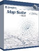
Map Suite Web Edition is a powerful and feature-rich ASP.Net server control that enables C# and VB.NET software developers to build detailed internet mapping applications. Utilizing Microsoft's .NET Framework, the APIs for Map Suite Web Edition incorporate the very latest technology to deliver a powerful, user-friendly .NET component that makes it easy to develop mapping...
Category: Software Development
Publisher: ThinkGeo LLC, License: Commercial, Price: USD $4794.00, File Size: 28.8 MB
Platform: Windows
 Freeware
Arm Map Explorer recreates all the functionalities of Google Maps on your desktop while expanding them with new extras. Map Explorer lets you locate and view any place on the planet using dynamic interactive maps. These maps are draggable, which means there is no need for you to click and wait for graphics to reload each time you want to view adjacent parts of a Map....
Category: Internet / Flash Tools
Publisher: ArmCode, License: Freeware, Price: USD $0.00, File Size: 5.5 MB
Platform: Windows
Anychart is a flexible Macromedia Flash based-solution, which allows you to easily display any sort of data dealing with geographical locations. It contains United States Maps with Counties, World Map, etc. XML data file and a set of customizable options make AnyChart Maps a universal solution for web developers. AnyChart allows you to create superb, compact, interactive maps....
Category: Software Development
Publisher: AnyChart.Com, License: Shareware, Price: USD $199.00, File Size: 2.8 MB
Platform: Windows, Mac, Linux, Palm,
This software displays two versions of the World Map, a day, and a night version, and fades between them to show which portions of the World are in daylight, and which aren't. In other words, this is a dynamic wallpaper that updates based on where the sun is relative to the surface of the earth. Version 0.12 is the most stable so far. Users of previous versions are...
Category: Audio / Utilities & Plug-Ins
Publisher: here there software, License: Freeware, Price: USD $0.00, File Size: 13.0 KB
Platform: Windows
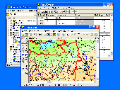
GIS ObjectLand is a universal Geographic Information System for Windows. Key features: - creation of vector-raster maps with arbitrary structure of layers and feature types; - creation of themes. Theme is a user presentation of a Map; - control of displaying features depending on the chosen scale; - spatial data input and editing by assigning feature coordinates and also by...
Category: Business & Finance
Publisher: Radom-T, License: Shareware, Price: USD $99.00, File Size: 24.0 MB
Platform: Windows
Get a full 3D satellite map view of El Petacon on your PC.
Get a full 3D satellite Map view of El Petacon on your PC. If you have already installed Google Earth, you will be able to view the El Petacón 3D Map. You will enjoy a beautiful view of this geographic place and you will have the World's geographic information at your fingertips.
Category: Home & Education / Miscellaneous
Publisher: Maplandia, License: Freeware, Price: USD $0.00, File Size: 331 B
Platform: Windows
Demo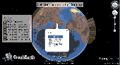
Visualize your data in 3D! Quick, easy and inexpensive. Graph Earth enables management, marketing and other business professionals to create stunning visual representations of their data, all without the time and costs associated with a full-featured GIS. Viewable by Everyone! Create one of a kind deliverables and distribute them to the World, recipients need only install Google Earth...
Category: Business & Finance / MS Office Addons
Publisher: Deer Creek Marketing LLC, License: Demo, Price: USD $24.95, File Size: 469.0 KB
Platform: Windows
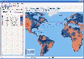
WoS stands for "World Of Statistics" and is a tool statisticians and economists will find valuable and useful. The main purpose of WoS is to create statistical Map charts of the World. Users can define their data in a tabular format Country/Value and then display the statistical Map with countries colored according to their values. The maps can then be...
Category: Business & Finance / Applications
Publisher: Silviu Lita, License: Demo, Price: USD $0.00, File Size: 0
Platform: Windows, Mac, Linux, Unix, Java
Now you can trace your network activity on World Map.GEO Spider helps you to trace, identify and monitor your network activity on World Map.You can trace any website or IP address. Whois reports give to you more info about site, host, domain, ip address...
Category: Internet / Tools & Utilities
Publisher: Oreware.com, License: Shareware, Price: USD $20.00, File Size: 10.4 MB
Platform: Unknown
Empires are controlled from three main views: the Campaign Map shows the entire game World, including mountains, forests, coastlines, oceans, rivers, cites, and armies. The City Map gives players an overview of the structure and role of a city within the empire, and provides a basis for economic decisions. The Battle Map is to be used when diplomacy has run its...
Category: Games / Strategy & War
Publisher: Slitherine, License: Shareware, Price: USD $12.99, File Size: 79.7 MB
Platform: Windows
EarthquakeView is a program that provides real-time information about earthquakes.
EarthquakeView is a program that provides real-time information about earthquakes. Its purpose is to inform you when new quakes occur around the World and provide some basic data about them by means of an interactive Map. It is an application intended for informational purposes and its developers say that is not to be used as a tool to 'determine risks'.
...
Category: Home & Education / Miscellaneous
Publisher: Robomagic Software Corporation, License: Shareware, Price: USD $19.95, File Size: 3.3 MB
Platform: Windows
This Map includes the most detailed and exhaustive coverage of the Angkor Wat area, all temples in the World Heritage Site, and all roads, paths and trails around and between the temples.
The mapset is processed to work seamlessly with all Rotweilermaps.com maps of countries surrounding Cambodia.
The Map includes numerous motorcycle and 4 wheel-drive...
Category: Home & Education / Miscellaneous
Publisher: Cambodia-gps, License: Shareware, Price: USD $0.00, File Size: 0
Platform: Windows
Remere's Map Editor is a map editor for the OpenTibia Project which was created by Remere.
Remere's Map Editor is a Map editor for the OpenTibia Project which was created by Remere.
Remere's Map Editor is a Map editor coded in C to be used with OpenTibia. It supports many advanced features such as autobordering and placing of composite objects. Runs under both Linux and Windows using wxWidgets and OpenGL.
Category: Games / Tools & Editors
Publisher: Remere, License: Shareware, Price: USD $0.00, File Size: 4.2 MB
Platform: Windows
Displays a discreet yet sophisticated World Map showing the local time in a selection of 55, user customizable, cities from a built-in list of over 3500 cities. Automatically calculates summer time changes, and times relative to your current location. Also shows which cities are in in darkness, or daylight or twilight. Automatically adjusts to your screen resolution.
Category: Desktop Enhancements / Misc. Themes
Publisher: Alter Ego Services, License: Shareware, Price: USD $0.00, File Size: 0
Platform: Windows
GeoVisu is a program that displays georeferenced data (images, graphics) and downloads data recorded by some GPS devices.
GeoVisu has a "Moving Map" navigation function, which can be used with any NMEA 0183 compatible or Garmin USB GPS device.
Main features:
- Displays georeferenced image formats : GeoTiff, ECW and ECWP, MrSID, OziExplorer...
Category: Multimedia & Design / Graphics Viewers
Publisher: GeoVisu, License: Freeware, Price: USD $0.00, File Size: 1.7 MB
Platform: Windows
View world clocks, time zones, and a day and night map, and keep track of public holidays.
View World clocks, time zones, and a day and night Map, and keep track of public holidays. This program is ideal for businesspeople, travelers, and anyone who wants to stay in touch with colleagues, family, or friends around the World. It displays the current local times of all selected cities with automatic time-zone and daylight-saving adjustments, pre-set alarm...
Category: Business & Finance / Applications
Publisher: Esoteric Technologies Pty Ltd, License: Shareware, Price: USD $22.00, File Size: 2.5 MB
Platform: Windows
Freeware
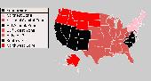
An interactive Flash USA Map with all the features you need for your web site or project. This is the ideal solution for dealer maps, real-estate listings, or visualizing state statistics. Nearly every aspect of the Map is customizable. However, unlike competing products, our Map is very simple to install and edit. Just upload XML and SWF files and embed.
Category: Internet / Flash Tools
Publisher: http://www.flashusamap.com/trial/flashus, License: Freeware, Price: USD $0.00, File Size: 93.8 KB
Platform: Unknown
Map of Africa is one of the many maps created for GPS TrackMaker.
Map of Africa is one of the many maps created for GPS TrackMaker. You are able to download the installation package from the TrackMaker website. In order to preview the contents of this package, you need to install GPS TrackMaker.
Using the above mentioned application, you will be able to see the Map of Africa. Just click on the "Open Temporary...
Category: Home & Education / Miscellaneous
Publisher: Geo Studio Technology, License: Freeware, Price: USD $0.00, File Size: 18.3 MB
Platform: Windows
Versamap draws outline maps on 16 map projections.
Versamap draws outline maps on 16 Map projections. The program allows users to print publication quality maps; and to export maps in vector graphic (WMF, CGM, DXF, ASCII) and bitmapped (BMP) formats. Versamap is supplied with digital maps from the Versamap Micro World Database, a World Map with 220,000 points in 10 geographic features. Versamap may be ordered with...
Category: Home & Education / Genealogy
Publisher: Versamap, License: Shareware, Price: USD $30.00, File Size: 4.0 MB
Platform: Windows
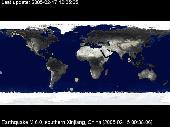
QuakeSaver is a Windows screensaver which shows, geolocalized on a true color Earth Map, recent earthquakes. You can choose to display past day earthquakes, or past week earthquakes on the full World Map, or select a specific region. Surprise your friends, relatives or colleagues, showing them how many earthquakes hit our planet everyday!
Category: Desktop Enhancements / Screensavers
Publisher: MGShareware, License: Shareware, Price: USD $15.00, File Size: 1.8 MB
Platform: Unknown
A user configurable World clock that can display a number of clocks in different time zones. As well as changing the label and timezone of each clock, the user may change the background colour and the text colour to suit their individual tastes. A World Map can be displayed and optionally the World time zones, and current areas of day and night can be superimposed on...
Category: Desktop Enhancements
Publisher: Castle Software Ltd, License: Shareware, Price: USD $19.95, File Size: 2.1 MB
Platform: Unknown
World Time is a simple to use but intelligent graphical utility that displays in real time, not only the time in cities around the World, but it also features viewable time zones, which displays night and day around the World. World Time features cloud maps, which allow you to view animated cloud formations from around the World using satellite imaging...
Category: Home & Education / Miscellaneous
Publisher: Trellian Limited, License: Shareware, Price: USD $0.00, File Size: 0
Platform: Windows