Free Downloads: Delphi Gis Vcl
License: All | Free
The VCL Provider is a very simple Delphi program that checks that these files are installed.
The Vcl Provider is a very simple Delphi program that checks that these files are installed. However, it is packaged in a Setup program that installs the Delphi runtime files on to your computer.
Vcl Provider requires the Delphi runtime files VCL50.BPL and VCLX50.BPL.
Category: Software Development / Components: Delphi
Publisher: Colin Wilson, License: Freeware, Price: USD $0.00, File Size: 1.4 MB
Platform: Windows
 Freeware
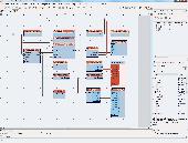
The OpenWire Editor is a powerful graphical editing Delphi and C++ Builder PlugIn. The Editor provides an intuitive easy way to design and build OpenWire applications in Vcl and FireMonkey(FMX) simply by connecting Vcl or FireMonkey components and making wiring dataflow diagrams. In the OpenWire Editor, the "wires" are like those connecting a TV to a VCR, or speakers to a...
Category: Software Development / Components: Delphi
Publisher: Mitov Software, License: Freeware, Price: USD $0.00, File Size: 4.2 MB
Platform: Windows
AvisMap Gis Engine is the basic development platform for AvisMap Gis suites, which is a new generation component Gis development platform for Gis application developers. AvisMap Gis Engine 5 provides powerful Gis functions through Active X controls based on Microsoft COM component technique standards. It allows users to rapidly develop professional...
Category: Multimedia & Design / Multimedia App's
Publisher: AvisMap GIS Technologies, License: Freeware, Price: USD $0.00, File Size: 60.5 MB
Platform: Windows
Synactis PDF Viewer for Delphi is a Vcl componentcapable of printing PDF files and displaying them on your Delphi forms.Easy to operate. Freeware ! Just place the TPdfViewer component on a form of your Delphi application then assign the FileName property to get the PDF file displayed. SUPPORTED PLATFORMS---------------------------------------------all Microsoft...
Category: Software Development / Compilers & Interpreters
Publisher: Synactis, License: Freeware, Price: USD $0.00, File Size: 1.5 MB
Platform: Windows
DIVA-GIS is a GIS for plant biodiversity analysis.
DIVA-Gis is a Gis for plant biodiversity analysis. The project will modernize the architecture for better collaboration and extensibility based on Eclipse RCP.
DIVA-Gis can be used to map and analyze biological distribution data, such as can be provided by natural history collections and genetic resources collections. Typically, the distribution data would refer to...
Category: Business & Finance / Business Finance
Publisher: International Potato Center (CIP), License: Freeware, Price: USD $0.00, File Size: 122.4 MB
Platform: Windows
Find what you want for your Delphi or C++ Builder IDE at www.Delphi-files.com web site. Simplest desktop program that helps you to find the component for your programming in the Delphi or C++ Builder Integrated Development Environment. Put the search string and find variations of components (Vcl) or source code examples right at the web site.
Category: Software Development
Publisher: TM Services, License: Freeware, Price: USD $0.00, File Size: 200.0 KB
Platform: Windows
DIVA-Gis is a free computer program for mapping and geographic data analysis (a geographic information system (Gis). With DIVA-Gis you can make maps of the world, or of a very small area, using, for example, state boundaries, rivers, a satellite image, and the locations of sites where an animal species was observed.
Category: Business & Finance / Applications
Publisher: diva-gis, License: Freeware, Price: USD $0.00, File Size: 3.8 MB
Platform: Windows
LangTools it's a complex tool for Delphi application localization.
LangTools it's a complex tool for Delphi application localization. It contains Vcl components, editors and wizards built-in Delphi and external language file editor.<br>Package LangTools was designed for developers, to localize software products. The package divides project into the text data pieces that can be edited separately.
Category: Software Development / Compilers & Interpreters
Publisher: CodresTeam, License: Freeware, Price: USD $0.00, File Size: 4.0 MB
Platform: Windows
LinLocalize for Windows is a translation tool running on Windows for easy localization of your Delphi-applications. Linlocalize extracts all embedded Delphi-resources (resource strings and forms) of a Windows-PE-file (Portable Executable: shared-object-file/dynamic-link-library or executable) and writes the translated texts back to a shared-resource-file or standalone executable....
Category: Utilities / Command Line Utilities
Publisher: SourceForge, License: Freeware, Price: USD $0.00, File Size: 1.9 MB
Platform: Windows
The Quantum GIS Tethys repository contains a lot of software from OSGeo projects.
The Quantum Gis Tethys repository contains a lot of software from OSGeo projects. Quantum Gis Tethys and all dependencies are included, along with Python, GRASS, GDAL, etc. This is most suitable for people who want to be able to update dependencies from the Quantum Gis Tethys repository easily. The installer is able to install from internet or just download all needed...
Category: Multimedia & Design / Graphics Viewers
Publisher: QGIS Development Team, License: Freeware, Price: USD $0.00, File Size: 369.0 KB
Platform: Windows
Active Query Builder Vcl Edition is a visual query builder component suite for Borland Delphi and C Builder that allows your end-users to build SQL queries with unions and subqueries via an intuitive visual interface.
Active Query Builder is also a powerful SQL parser that allows programmatic analysis and modification of complex SQL queries.
Category: Software Development / Components: Delphi
Publisher: Active Database Software, License: Freeware, Price: USD $0.00, File Size: 19.7 MB
Platform: Windows
A package of standard and unique skinable Vcl's for professional UI design development using "AlphaSkins". AlphaControls is an easy-to-use universal and powerful tool for developing original skinned and non-skinned business/media applications. We have also added some properties, which make AlphaControls (and the applications that use them) unique. - Skins are upgradeable and have a...
Category: Software Development
Publisher: AC Team, License: Freeware, Price: USD $0.00, File Size: 2.9 MB
Platform: Windows
So that you can identify the Mapping & Gis product that best suits your needs, use this simple Product Comparison. There are four main product types that you can use to create a GPS data collection and maintenance system, or mobile Gis solution. Use the links below to select a product group, and compare the features of each product within that group.
Category: Internet / Communications
Publisher: Trimble Navigation Limited, License: Freeware, Price: USD $0.00, File Size: 2.7 MB
Platform: Windows
AccuGlobe Desktop 2007,a standardized platform for delivering solutions to the global Gis community, offers even more of what you demand in a desktop Gis application. Combining user-friendly design with significantly increased functionality, AccuGlobe Desktop 2007 gives you greater freedom in analyzing spatial data. In addition to functioning as the core engine behind many...
Category: Multimedia & Design / Multimedia App's
Publisher: Digital Data Technologies, Inc., License: Freeware, Price: USD $0.00, File Size: 9.8 MB
Platform: Windows
GeoSurveillance is software that combines spatial statistical routines with some basic Geographic Information Systems (Gis) functions to carry out retrospective and prospective statistical tests for the detection of geographic clustering. In this software, the focus is primarily on the spatial statistical analysis. Consequently, full Gis functionality is not provided. Gis...
Category: Home & Education / Miscellaneous
Publisher: NCGIA, License: Freeware, Price: USD $0.00, File Size: 2.4 MB
Platform: Windows
Freeware
VSceneGIS Desktop. (Gis) Analysis, Computing and Editing. Customer Project Development, Analysis, Computing and Gis editing. VSceneGIS Desktop applies the concept of Tree and Graph Topology to implement the data model in a Gis. Validation, Editing and Topological Behavior Export and import of data sources: PostgreSQL / PostGIS, Oracle, MySQL, SQLite / SpatiaLite,...
Category: Home & Education / Science
Publisher: vscenegis.com, License: Freeware, Price: USD $0.00, File Size: 118.4 MB
Platform: Windows
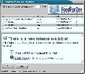
FeedForDev Vcl Control and ActiveX components makes it simple to communicate with users from within your software application! Integrate components into your application, to communicate with users. Use standard RSS feeds and provide users. All you have to do is add the FeedForDev component to your existing project. Set the URL to your RSS feed, and let it do the rest. You can then ask...
Category: Software Development
Publisher: NotePage, Inc., License: Freeware, Price: USD $0.00, File Size: 1.4 MB
Platform: Windows
Freeware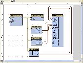
OpenWire offers yot a free open source library for writing advanced Vcl/FireMonkey(FMX) components for Delphi, C++ Builder and RAD Studio. The purpose of the OpenWire project is to introduce unified easy way to transfer data among different Vcl/FireMonkey components. This is very similar to the way the products as LabView, Agilent VEE or Simulink work. For example, you...
Category: Software Development / Components: Delphi
Publisher: Mitov Software, License: Freeware, Price: USD $0.00, File Size: 39.4 MB
Platform: Windows
ArcGIS Explorer is a free, downloadable Gis viewer that gives you an easy way to explore, visualize and share Gis information. ArcGIS Explorer adds value to any Gis because it helps you deliver your authoritative data to a broad audience.
The ArcGIS Explorer Desktop Current User setup is intended for users who do not have administrator access on their computers and...
Category: Desktop Enhancements / Shell & Desktop Managers
Publisher: Environmental Systems Research Institute, Inc., License: Freeware, Price: USD $0.00, File Size: 94.0 MB
Platform: Windows
ESBTools for RAVE is an add-on for Nevrona RAVE that supplies the following: Calculator Property Editor - When you have a Property that is a Float, then you will be able to bring up the ESBPCS Calculator - a full featured Scientific Calculator with Memory. Coloured Number DataText Component - This allows you a DataText that has the following abilities: a) Set Different Colour of Values...
Category: Software Development
Publisher: ESB Consultancy, License: Freeware, Price: USD $0.00, File Size: 1.2 MB
Platform: Windows
Quantum Gis provides a continously growing number of capabilities provided by core functions and plugins. You can visualize, manage, edit, analyse data, and compose printable maps. QGIS is an official project of the Open Source Geospatial Foundation (OSGeo). It runs on Linux, Unix, Mac OSX, and Windows and supports numerous vector, raster, and database formats and functionalities.
Category: Home & Education / Miscellaneous
Publisher: qgis.org, License: Freeware, Price: USD $0.00, File Size: 92.2 MB
Platform: Windows
ArcGIS Explorer Desktop is a free Gis viewer that gives you an easy way to explore, visualize, and share Gis information. ArcGIS Explorer adds value to any Gis because it helps you deliver your authoritative data to a broad audience.
Easy and intuitive to use it's easy for anyone to begin working with ArcGIS Explorer, with its intuitive and easy to use...
Category: Home & Education / Miscellaneous
Publisher: Environmental Systems Research Institute, Inc., License: Freeware, Price: USD $0.00, File Size: 100.5 MB
Platform: Windows
GeoMedia Viewer is an easy to use, FREE Gis software application for desktop viewing and distribution of geospatial data.It allows an organization to maximize the value of its geospatial data by extending availability to novice users who wouldn’t otherwise have access because of the barriers of purchasing and learning how to use a full Gis software application.
Category: Multimedia & Design / Graphics Viewers
Publisher: Intergraph Corporation, License: Freeware, Price: USD $0.00, File Size: 115.0 MB
Platform: Windows
GenesisIV understands GIS concepts like layers, shape objects and georeferencing.
GenesisIV understands Gis concepts like layers, shape objects and georeferencing. It interfaces to industry standard Gis systems such as MapInfo and ArcView so you can use your existing data without having to learn new concepts or perform difficult manipulations.
GenesisIV is the only landscape product designed specifically to help teach geographical concepts....
Category: Multimedia & Design / Multimedia App's
Publisher: Geomantics, License: Freeware, Price: USD $0.00, File Size: 17.6 MB
Platform: Windows
The Microdrone Airborne Mapping extension to Orbit Gis provides the tools required for automated flight and high precision mapping. It contains a Waypoint Generator, a Microdrone in-flight tracker, and a captation tool. Further image-, stereoprocessing and orthorectification can be executed using the Strabo Photogrammetry extension to Orbit Gis.
Category: Multimedia & Design / Multimedia App's
Publisher: Orbit GeoSpatial Technologies, License: Freeware, Price: USD $0.00, File Size: 30.0 MB
Platform: Windows
NexGeo Office™ provides all of the functionality needed to organize a data collection project and manage data collected from Nexteq GPS/Gis handhelds. It provides tools for viewing, editing and exporting data to a format suitable for your existing Gis and CAD infrastructure.
Category: Multimedia & Design / Image Editing
Publisher: Nexteq Navigation, License: Freeware, Price: USD $0.00, File Size: 7.4 MB
Platform: Windows
With MapAuthor you can create, print and save desktop maps, using data that you obtain from commercial sources or perhaps your in-hous Gis department as shapefiles (shapefiles are a very common Gis exchange format.) You can also produce internet-based maps based on Google Maps, for use on your web site.
MapAuthor allows you to link your own data to maps, for example if you...
Category: Internet / Misc. Plugins
Publisher: MapAuthor.com, License: Freeware, Price: USD $0.00, File Size: 6.3 MB
Platform: Windows
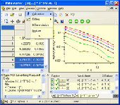
Data Master 2003 Vcl component library provides you with high performance 2D graphics engine specially optimized for scientific and technical applications as well as other reusable components created for DM2003 software. You can visualize and edit numeric data as plot curves and worksheets, create presentation-quality graphs with a lot of properties, display real-time streams of data...
Category: Software Development
Publisher: RRR, License: Freeware, Price: USD $0.00, File Size: 164.8 KB
Platform: Windows
SuperGIS DataConvertor is a powerful data conversion tool which is able to convert files between the common Gis formats to the SuperGeo self-defined formats. Therefore, your data can be used in SuperGeo series products, and also the SuperGeo self-defined formats can be used in other related platforms or systems. You will no longer need to worry the compatibility of Gis data, and...
Category: Business & Finance / Calculators
Publisher: SuperGeo, License: Freeware, Price: USD $0.00, File Size: 3.2 MB
Platform: Windows
The programming language Object Pascal in the Delphi environment allows to use only sets of maximum size of 256 elements (Set Of Byte or Set Of Char). TSetOfInteger is a class, which can pass this limit and allows to use unlimited set of integers in similar way, as it is possible to work with common sets. The size of a set is limited only by the amount of the free memory.
Category: Software Development / Components: Delphi
Publisher: Michal Kokorceny, License: Freeware, Price: USD $0.00, File Size: 282.3 KB
Platform: Windows, Mac, Linux, iPhone, iPod, iTouch, Other
Introducing the WMI Delphi Code Creator tool allows you to generate Delphi code that uses WMI to complete a management task such as querying for wmi data.
This freeware tool is inspired by the WMI Code Creator.
Features :
- reate full Delphi console project
- create a 100% functional Delphi procedure wich encapsulates the logic to retrieve WMI...
Category: Home & Education / Miscellaneous
Publisher: Rodrigo Ruz V., License: Freeware, Price: USD $0.00, File Size: 1.5 MB
Platform: Windows
spatialSQL help contains a detailed description of solutions to some common GIS problems.
spatialSQL help contains a detailed description of solutions to some common Gis problems.
The interface provides a simple mechanism for selecting tables, spatialSQL operators, where clause, distance and other qualifiers and update operators. See the description of features and benefits.
Category: Software Development / Misc. Programming
Publisher: Spatial Projects, License: Freeware, Price: USD $0.00, File Size: 7.6 MB
Platform: Windows
The abfComponents product is a base part of the ABF Visual Components Library, contains a set of powerful and easy-to-use common components, lots of classes and procedures. Product is compatible with all 32-bit versions of Borland Delphi and C++Builder. abfComponents is free for non-commercial usage, you can freely download a full featured version. If you are planning to use this product...
Category: Software Development
Publisher: ABF software, Inc. (ABF-DEV.COM), License: Freeware, Price: USD $0.00, File Size: 416.7 KB
Platform: Windows
AutoDEM (aka as AutoMNT) is a freeware Gis software to create Digital Elevation Models (DEM) from scanned topographic maps for Windows.
Through different data layers (map, contours, DEM, etc.), AutoDEM provides many tools for :
-Topographic map analysis
-Contour lines extraction and reconstruction
-Contours to DEM interpolation and DEM analysis
-DEM to TIN...
Category: Multimedia & Design / Animation
Publisher: Joachim Pouderoux, License: Freeware, Price: USD $0.00, File Size: 27.6 MB
Platform: Windows
GeoBase is a high performance OEM tool for embedding Gis functions in client and server applications. GeoBase has a small memory footprint - both on the hard disk for storage and in RAM during use. Compatible with both .NET and Linux, GeoBase is designed for a rapid development cycle and low deployment cost. The Map Engine displays rich, detailed maps for use in server or client...
Category: Software Development / Compilers & Interpreters
Publisher: Telogis, License: Freeware, Price: USD $0.00, File Size: 87.0 MB
Platform: Windows
Universal Data Access Components (UniDAC) is a powerful library of nonvisual cross-database data access components for Delphi, Delphi for .NET, C Builder, and Lazarus (Free Pascal). We have combined the experience of long-term successful development into one product, which provides unified access to the popular database servers like Oracle, Microsoft SQL Server,MySQL and other...
Category: Utilities / Misc. Utilities
Publisher: Devart, License: Freeware, Price: USD $0.00, File Size: 5.6 MB
Platform: Windows
gvSIG project is a free and open source Geoinformation System (Gis), that enables users to interactively visualize, manage, modify and analyze spatial information in the form of digital maps, images and database tables. It is easy to learn, yet versatile and efficient enough for demanding Gis tasks.
Category: Multimedia & Design / Multimedia App's
Publisher: Oxford Archaeology Digital, License: Freeware, Price: USD $0.00, File Size: 273.0 MB
Platform: Windows

The free AvisMap Viewer opens most Gis/CAD and raster image file types and most ArcView, ArcExplorer, and MapInfo projects. Besides just opening and viewing files, the Viewer supports an extensive list of features including visual layer properties control, legend control, thematic mapping, spatial and attribute querying, custom labeling, on-map measurements, hyper-linking, PDF export...
Category: Software Development / Components & Libraries
Publisher: AvisMap GIS Technologies, License: Freeware, Price: USD $0.00, File Size: 22.3 MB
Platform: Windows
The Mapping and Gis License Manager software allows you to manage multiple licenses for the GPS Pathfinder Office software. Using the GPS Pathfinder Office License Administrator software, users of the GPS Pathfinder Office software can choose either a single use or a floating license.
Category: Business & Finance / Business Finance
Publisher: Trimble, License: Freeware, Price: USD $0.00, File Size: 26.8 MB
Platform: Windows
This program helps to create displaying message box code in Delphi.
This program helps to create displaying message box code in Delphi. It supports Delphi?s MessageDlg and Application.MessageBox flavors.
Category: Software Development / Components: Delphi
Publisher: sites.google.com, License: Freeware, Price: USD $0.00, File Size: 837.0 KB
Platform: Windows, Mac, Vista
PlanetGIS Explorer is a free viewer for PlanetGIS maps and GIS exchange files.
PlanetGIS Explorer is a free viewer for PlanetGIS maps and Gis exchange files. PlanetGIS Explorer allows you to navigate through maps, query map elements and view attribute information from linked database tables. Also PlanetGIS Explorer allows you to customize the appearance of maps for purposes of creating hardcopy printouts, but does not allow you to save any changes to maps.
Category: Multimedia & Design / Graphics Viewers
Publisher: Planet GIS, License: Freeware, Price: USD $0.00, File Size: 5.4 MB
Platform: Windows
Delphi Package Installer (DelphiPI) is a tool which aids you installing components to your Delphi IDE. DelphiPI automatically resolves dependencies between packages, compiles, installs and adds source paths to your IDE. Select the folder where both package file (*.dpk) and source files (*.pas) reside.
Category: Business & Finance / Database Management
Publisher: Google, License: Freeware, Price: USD $0.00, File Size: 126.3 KB
Platform: Windows
Cityvu is a 3D GIS data viewer able to load CityGML data format from any compatible data source.
Cityvu is a 3D Gis data viewer able to load CityGML data format from any compatible data source.
Cityvu features 3D hardware rendering using OpenGL with a complete navigation system that allows automated tour of the rendered scene. It has been designed to be used to develop customized software solutions, built on the specific needs. Cityvu supports in addition to CityGML,...
Category: Multimedia & Design / Graphics Viewers
Publisher: 3D GIS Cityvu, License: Freeware, Price: USD $0.00, File Size: 9.9 MB
Platform: Windows
The MapSys Cadastral Gis offers specialized functionality for each stage of processing including the digital map creation, plotting cadastral and topographical plans, generating and combining geo-referenced data in order to obtain a validated relational geo-database. This can be used in MapSys or in other Gis programs or database application.
Category: Home & Education / Teaching Tools
Publisher: GEOTOP, License: Freeware, Price: USD $0.00, File Size: 143.9 MB
Platform: Windows
Speller contains two components designed for Delphi: TSpellChecker and TSpellLanguageComboBox. TSpellChecker is a non-visual Delphi component designed to add spell check capability to any application. It uses ISpell dictionaries installed with "ISpell - LS-Distribution". You find it on my web site http://www.luziusschneider.com Additionally, TSpellChecker can use spell check...
Category: Software Development
Publisher: Luzius Schneider, License: Freeware, Price: USD $0.00, File Size: 99.0 KB
Platform: Windows
Freeware
Convert ESRI ShapeFiles (.SHP) geolocation data into AnyMap format to be used with AnyChart. AnyChart Flash Map Converter allows making use of a wide choice of maps with AnyChart Flash Component, a Gis visualization system that recognizes map data in AnyMap format only. AnyChart Flash Map Converter makes it easy to visualize any geolocation data without hefty expenses associated with...
Category: Web Authoring / Image Mapping Tools
Publisher: AnyChart.Com, License: Freeware, Price: USD $0.00, File Size: 1.6 MB
Platform: Windows
DNRGarmin is a smart tool used to directly transfer data between Garmin GPS handheld receivers and various Gis software packages.
DNRGarmin was built to provide users the ability to directly transfer data between Garmin GPS handheld receivers and various Gis software packages. Using DNRGarmin a user can use point features (graphics or shapefile) and upload them to the...
Category: Utilities / Misc. Utilities
Publisher: GIS Section, Minnesota Department of Natural Resources, License: Freeware, Price: USD $0.00, File Size: 11.3 MB
Platform: Windows
Use this software option to differentially post-process raw GPS data collected with the Ashtech MobileMapper Field software. Through post-processing, the positions of every Gis feature you collect in the field can be improved to sub meter (< 1m) accuracy. Create and update maps for analysis and maintenance in a standard Gis system.
Category: Business & Finance / Business Finance
Publisher: Magellan, License: Freeware, Price: USD $0.00, File Size: 119.2 MB
Platform: Windows
The MapInfo License Server must be installed on your network and be accessible to all MapInfo Professional users. MapInfo Professional is a powerful Microsoft Windows-based mapping and geographic analysis application from the experts in location intelligence. Designed to easily visualize the relationships between data and geography, MapInfo Professional helps business analysts, planners,...
Category: Home & Education / Miscellaneous
Publisher: Pitney Bowes MapInfo, License: Freeware, Price: USD $0.00, File Size: 12.1 MB
Platform: Windows
Rx-Lib is a complete set of components for Borland Delphi and C Builder that allow you to build flexible and robust user interfaces and best of all they are totally free. NOTE: This project is in maintenance mode and no longer actively developed.
RX Lib (or RX Library) is large library of components and functions for Delphi all versions.
Category: Software Development / Components: Delphi
Publisher: Borland Software Corporation, License: Freeware, Price: USD $0.00, File Size: 1.6 MB
Platform: Windows