Free Downloads: Et Surface For Arcgis And
License: All | Free
Arcgis Explorer is a free, downloadable GIS viewer that gives you an easy way to explore, visualize and share GIS information. Arcgis Explorer adds value to any GIS because it helps you deliver your authoritative data to a broad audience.
The Arcgis Explorer Desktop Current User setup is intended for users who do not have administrator access on their computers and...
Category: Desktop Enhancements / Shell & Desktop Managers
Publisher: Environmental Systems Research Institute, Inc., License: Freeware, Price: USD $0.00, File Size: 94.0 MB
Platform: Windows
Projection Engine Expansion Pack - Adds more projections and geotransformations for use with Arcgis Explorer Desktop.
Arcgis Explorer Desktop adds value to any GIS because it helps you deliver your authoritative data to a broad audience.
With Arcgis Explorer Desktop, you can access ready-to-use Arcgis Online basemaps and layers.
Category: Multimedia & Design / Multimedia App's
Publisher: Environmental Systems Research Institute, Inc., License: Freeware, Price: USD $0.00, File Size: 69.9 MB
Platform: Windows
The Arcgis Military Analyst extension incorporates a suite of display and analysis tools tailored to meet the special needs of the defense and intelligence user. With Arcgis Military Analyst, you can create, query, analyze, and display spatial data in a variety of formats.
Arcgis Military Analyst maximizes the use of the standard suite of the Department of...
Category: Multimedia & Design / Multimedia App's
Publisher: Environmental Systems Research Institute, Inc., License: Freeware, Price: USD $0.00, File Size: 31.9 MB
Platform: Windows
The Arcgis Editor for OpenStreetMap is designed to help Arcgis Desktop users to become active members in the growing community of users building an open and freely available database of geographic data.
The provided tools allow you to download data from the OSM servers and store it locally in a geodatabase. You can then use the familiar editing environment of...
Category: Business & Finance / Business Finance
Publisher: ESRI, License: Freeware, Price: USD $0.00, File Size: 3.6 MB
Platform: Windows
Arcgis Image Server is designed to be open, enabling developers to expand its functionality and integrate it with their applications. The core structures that Arcgis Image Server uses are a combination of Extensible Markup Language (XML) and simple tables stored as shapefiles. The Service Editor component provides a graphic user interface (GUI) that enables you to create services...
Category: Utilities / Misc. Utilities
Publisher: Environmental Systems Research Institute, Inc., License: Freeware, Price: USD $0.00, File Size: 3.8 MB
Platform: Windows
Arcgis Explorer Desktop is a free GIS viewer that gives you an easy way to explore, visualize, and share GIS information. Arcgis Explorer adds value to any GIS because it helps you deliver your authoritative data to a broad audience.
Easy and intuitive to use it's easy for anyone to begin working with Arcgis Explorer, with its intuitive and easy to use...
Category: Home & Education / Miscellaneous
Publisher: Environmental Systems Research Institute, Inc., License: Freeware, Price: USD $0.00, File Size: 100.5 MB
Platform: Windows
This utility adds LAS file read capability to ArcGIS.
This utility adds LAS file read capability to Arcgis. Point x, y, z, intensity, return and classification values are read from the file and presented as a standard 3-D point data layer which can then be used as input to extensions such as 3-D Analyst.
Category: Multimedia & Design / Multimedia App's
Publisher: GeoCue, License: Freeware, Price: USD $0.00, File Size: 8.4 MB
Platform: Windows
The API is built on the Microsoft Silverlight platform which is integrated with Visual Studio 2010 and Expression Blend 4. The Arcgis API for Silverlight enables you to create rich internet and desktop applications that utilize the powerful mapping, geocoding, and geoprocessing capabilities provided by Arcgis Server and Bing™ services.
To use the API, simply download...
Category: Software Development / Misc. Programming
Publisher: ESRI, License: Freeware, Price: USD $0.00, File Size: 7.7 MB
Platform: Windows
G2G is a P2P (peer to peer) extension for ArcGIS Desktop.
G2G is a P2P (peer to peer) extension for Arcgis Desktop. The extension allows two or more users to collaborate without any intermediate server. G2G (gis to gis) supports:
1) Text chatting,
2) Exchange of map content (geo-referenced screenshots),
3) Ink and graphics collaboration (shared editing),
4) Share navigation (one person can pan the map display of other...
Category: Internet / Misc. Servers
Publisher: ESRI, License: Freeware, Price: USD $0.00, File Size: 1.3 MB
Platform: Windows
The Geosoft Plug-in for Arcgis is an extension to the Arcgis desktop software that provides data retrieval using DAP and also support for reading Geosoft file formats. The plug-in enables users to view Geosoft grid files as a raster layer inside ArcMap. The plug-in also enables users to view Geosoft Maps as layers.
Geosoft plug-in for Arcgis includes access to Seeker,...
Category: Utilities / Misc. Utilities
Publisher: Geosoft Inc., License: Freeware, Price: USD $0.00, File Size: 133.5 MB
Platform: Windows
The Infrastructure Mobile Map template is an Arcgis Mobile application that can be used by field operations and maintenance staff in a water utility or public works department. This mobile application includes two multi-scale mobile maps (daytime and nighttime) that can be used in a disconnected network environment, two online basemaps that were authored from the Local Government Basemap...
Category: Internet / Communications
Publisher: ESRI, License: Freeware, Price: USD $0.00, File Size: 515.4 MB
Platform: Windows
Markov Random Field Surface Reconstruction (MRFSurface) is a Surface reconstruction and remeshing method. It has been tested on modestly sized datasets and the results are comparable to current state-of-the-art algorithms. In particular, it has been shown to be well suited for hole filling in Surface scans of human faces. Currently, a compiled version is available for free...
Category: Multimedia & Design / Multimedia App's
Publisher: Rasmus R. Paulsen, License: Freeware, Price: USD $0.00, File Size: 8.2 MB
Platform: Windows
ArcReader is a free, easy-to-use desktop mapping application that allows users to view, explore, and print maps and globes. Anyone with ArcReader can view high-quality interactive maps authored by a high-level Arcgis Desktop product and published with the Arcgis Publisher extension.
ArcReader is a free and easy-to-use application that allows users to view and print...
Category: Desktop Enhancements / Shell & Desktop Managers
Publisher: Environmental System Research Institute, Inc., License: Freeware, Price: USD $0.00, File Size: 499.2 MB
Platform: Windows
SWATeditor is a companion software to ArcSWAT.
SWATeditor is a companion software to ArcSWAT. SWATeditor reads the project database generated by ArcSWAT interface to edit swat input files, execute SWAT, perform sensitivity, autocalibration and uncertainty analysis. This is a standalone program and does not require Arcgis, thus helping users of ArcSWAT to share their project with others that do not have Arcgis or much...
Category: Business & Finance / Applications
Publisher: Grassland, Soil & Water Research Laboratory, USDA-ARS, License: Freeware, Price: USD $0.00, File Size: 15.6 MB
Platform: Windows
This program allows connections to personal geodatabases and multi-user geodatabases using the 2-tier connect architecture (direct-connect). To install this little program, first you need to have on your computer Arcgis Explorer software. The software is easy to install and easy to manipulate.
Category: Multimedia & Design / Image Editing
Publisher: Environmental Systems Research Institute, Inc., License: Freeware, Price: USD $0.00, File Size: 47.6 MB
Platform: Windows
The ArcPhoto Tools are a set of geoprocessing tools and ArcMap user interface enhancements to enable the quick import of digital photography into the Arcgis framework. The tools work directly off the EXIF (Exchangeable image file format) header information that is encoded into digital imagery. This information usually includes information about the type of camera used, focal length,...
Category: Multimedia & Design / Multimedia App's
Publisher: ESRI, License: Freeware, Price: USD $0.00, File Size: 25.0 MB
Platform: Windows
 Freeware
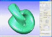
3DSurG can be used to create 3D Surface based on either 3D implicit function ( f(x,y,z)=0 ) or parametric function ( x=f(u,v), y=f(u,v), z=f(u,v) ). The generated 3D Surface can be easily scaled and exported to AutoCAD (*.DXF) and text file, or saved as various graphics data format such as Bitmap, JPG, and PNG. 3DSurG also provides rotation, pan, and zoom in/out to view generated...
Category: Home & Education / Science
Publisher: Toolware Technology Inc., License: Freeware, Price: USD $0.00, File Size: 967.8 KB
Platform: Windows
GWLF is considered to be a combined distributed/lumped parameter watershed model.
GWLF is considered to be a combined distributed/lumped parameter watershed model. For Surface loading, it is distributed in the sense that it allows multiple land use/cover scenarios, but each area is assumed to be homogenous in regard to various attributes considered by the model. Additionally, the model does not spatially distribute the source areas, but simply aggregates the loads...
Category: Business & Finance / Business Finance
Publisher: Penn State Institutes of Energy and the Environment, License: Freeware, Price: USD $0.00, File Size: 35.4 MB
Platform: Windows
QUIKGRID is a program which will read in a set of scattered data points (x, y, z) which represents a Surface. The program will generate a grid from this data and then display the Surface as a contour map, or as a coloured 3d grid. The left mouse button ma
Category: Home & Education / Mathematics
Publisher: perspectiveedge.com, License: Freeware, Price: USD $0.00, File Size: 484.0 KB
Platform: Windows, Mac, 2K
Alien vs. Triangles is a study in using tessellation on a dynamic animating character. Tessellation is most commonly used to add geometric complexity in a detailed area of a Surface. Alien vs. Triangles demonstrate this but goes far beyond just adding detail to a static Surface.
Category: Games / Action
Publisher: NVIDIA Corporation, License: Freeware, Price: USD $0.00, File Size: 263.8 MB
Platform: Windows
TrueMap software created by TrueGage is a Windows software solution that provides stunning 3D Surface visualization and a suite of powerful analytic tools. It is compatible with nearly all Surface metrology instruments. We currently support over 30 various microtopography file formats. Please contact us to add a format to this list.
Category: Multimedia & Design / Multimedia App's
Publisher: TrueGage, License: Freeware, Price: USD $0.00, File Size: 31.2 MB
Platform: Windows
The A-PRO control Surface plug-in enables full control of all SONAR tracks, buses, plug-ins and other parameters from your A-PRO MIDI keyboard controller.
A-PRO highlights:
- 9 assignable rotaries
- 9 assignable sliders
- 8-button transport section
- 4 buttons, and 8 pads with a HOLD button that can be used for a variety of functions
...
Category: Audio / Utilities & Plug-Ins
Publisher: Cakewalk Music Software, License: Freeware, Price: USD $0.00, File Size: 20.1 MB
Platform: Windows
3D Organic Modeling is a set of techniques that will help you to create realistic objects in 3D, and working with CB Model Pro is like if you would be sculpting those objects in a soft material mass. With traditional image editing programs, create those types of objects is sometimes really difficult and takes a lot of time, but with this application, model an image and create 3D stunning...
Category: Multimedia & Design / Multimedia App's
Publisher: SolidWorks Corp., License: Freeware, Price: USD $0.00, File Size: 12.0 MB
Platform: Windows
The free RADF Viewer provides real-time collaborative viewing of ACIS parts and assemblies.
The free RADF Viewer provides real-time collaborative viewing of ACIS parts and assemblies. Uses sophisticated algorithms to create high-quality n-sided surfaces that meet user-specified tolerances for position and tangency on boundaries and on optional internal guiding geometry. Advanced Covering allows a Surface to be fit onto circuits (collections of edges that form closed loops) in...
Category: Multimedia & Design / Graphics Viewers
Publisher: Spatial, License: Freeware, Price: USD $0.00, File Size: 25.1 MB
Platform: Windows
The Biogeography Branch’s Sampling Design Tool for Arcgis provides users a means to efficiently sample a population, be it people, animals, objects or processes, in a GIS environment. The tool was created for sampling when the population and component sampling units are defined by known dimensions.
The Sampling Design Tool was developed in response to a need by...
Category: Business & Finance / Applications
Publisher: Center for Coastal Monitoring and Assessment, License: Freeware, Price: USD $0.00, File Size: 236.7 KB
Platform: Windows
Displays lines and surfaces defined algebraically in 3D space in many forms, including z=f(x,y), cylindrical polar coordinates, and parametric definitions with one (giving a line) and two (Surface) parameters. View controls move the viewpoint through 3D space, using keyboard and mouse. There are options to display a Surface, a mesh or a combination. The number of 'steps' on each...
Category: Home & Education / Mathematics
Publisher: Walter Milner, License: Freeware, Price: USD $0.00, File Size: 962.0 KB
Platform: Windows
With this program you can make prints for your shirts or any other cloth that has a clean Surface to be printed with an image. The program is easy to install and use. Built-in options allows you to add your own image, border color or choose the position of your image.
Category: Multimedia & Design / Multimedia App's
Publisher: June Tailor, Inc., License: Freeware, Price: USD $0.00, File Size: 335.0 KB
Platform: Windows
Planet is covered by oceans, on its Surface there is so little land, nothing strange that the waves are so attractive.
Sparkling Waves slideshow thet comes with 29 amazing pictures will take you over the ocean to feel the fresh breeze of life.
Category: Desktop Enhancements / Screensavers
Publisher: free-slideshow.com, License: Freeware, Price: USD $0.00, File Size: 4.2 MB
Platform: Windows
Remote is a protocol for handling communication between control surfaces and software applications.
Remote is a protocol for handling communication between control surfaces and software applications. It handles everything from delivering MIDI note data from a keyboard to the application to using knobs, faders and buttons on a control Surface for tweaking synth parameters in the application, controlling transport.
Category: Audio / Utilities & Plug-Ins
Publisher: M-Audio, License: Freeware, Price: USD $0.00, File Size: 2.4 MB
Platform: Windows
Freeware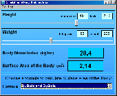
In physiology and medicine, the Body Surface Area (BSA) is the measured or calculated Surface of a human body. For many clinical purposes BSA is a better indicator of metabolic mass than body weight because it is less affected by abnormal adipose mass. Estimation of BSA is simpler than many measures of volume. BSAcalc is the freeware program for the calculation of the...
Category: Home & Education / Science
Publisher: Doctor-Soft, License: Freeware, Price: USD $0.00, File Size: 642.0 KB
Platform: Windows

This screensaver shows you off the beautiful images of higland lakes from different places on Earth. These places combine the rocky mountains and smooth Surface of lakes with crystal clear water. Just imagine the fresh air you can breathe in, the sun reflections on the lake Surface and the sweet taste of pure natural cold water! What a beautiful place the highland lake is!...
Category: Desktop Enhancements / Screensavers
Publisher: Cool-Savers.com, License: Freeware, Price: USD $0.00, File Size: 5.9 MB
Platform: Windows
Freeware
Desktop panorama is a panoramic virtual desktop where the virtual desktop area is represented as a small Surface above the windows taskbar and windows can be freely moved around it - in the same way as they can be moved around the normal desktop. Changing the view (the desktop) is done by selecting an area on the Surface using a mouse. Traditional desktop switching is also...
Category: Desktop Enhancements / Shell & Desktop Managers
Publisher: Dizel Deva, License: Freeware, Price: USD $0.00, File Size: 7.8 MB
Platform: Windows
Software with grafical user surface for programming the OCR Reader BR40 via the USB 2.
Software with grafical user Surface for programming the OCR Reader BR40 via the USB 2.0 interface.wenglor’s BS40 OCR Reader is an optoelectronic sensor which is used for contactless inspection of specific objects.wenglor’s BR40 range of OCR Readers integrates a camera unit, illumination, optics with auto-focus and an analysis module into a single housing.
Category: Business & Finance / Business Finance
Publisher: wenglor sensoric gmbh, License: Freeware, Price: USD $0.00, File Size: 0
Platform: Windows
This is a 3D simulation of the Mars Surface exploration done by the Rover remote operated vehicle Spirit.
NASA began to experience what seemed to be very dire communication problems with Spirit on January 22. However, after the incredible efforts of the Mars rover team, the problem has been diagnosed and the rover should be able to continue its scientific mission soon.
...
Category: Games / Misc. Games
Publisher: Brain Block Interactive, License: Freeware, Price: USD $0.00, File Size: 1.2 MB
Platform: Windows
Data is entered using a simple Excel-compatible spreadsheet.
Data is entered using a simple Excel-compatible spreadsheet. The resulting 3D Surface plots may be viewed, rotated, and copied to the clipboard. A variety of other data, spreadsheet, and image manipulations are available.
Main features:
- Point, wireframe and Surface images
- Image anti-aliasing
- Automatic enclosure of image (vertical walls...
Category: Multimedia & Design / Image Editing
Publisher: Gary Beene's Information Centers, License: Freeware, Price: USD $0.00, File Size: 3.4 MB
Platform: Windows
Freeware
Fantastic Ocean 3D takes you on a peaceful flight over the ocean, which is carefully recreated in true 3D. The effect is magical. It looks as if you were gliding on a paraglide several feet above the waves. The Surface of the ocean is like a sheet of glass. The setting sun is reflected on it with a hundred of different shades of color. The wonderful thing about the view is that it...
Category: Desktop Enhancements / Screensavers
Publisher: Rixane Interactive, License: Freeware, Price: USD $0.00, File Size: 1.7 MB
Platform: Windows
Easy2Convert DDS to JPG (dds2jpg) is a freeware designed to convert DirectDraw Surface files (.
Easy2Convert DDS to JPG (dds2jpg) is a freeware designed to convert DirectDraw Surface files (.dds) to JPEG files (.jpg, .jpeg, .jpe, .jif). You may also change the output image quality or size. The program allows you to add files for conversion by using drag-and-drop.
Category: Business & Finance / MS Office Addons
Publisher: Easy2Convert Software, License: Freeware, Price: USD $0.00, File Size: 1.2 MB
Platform: Windows
EWD 3D is a 3D CAD program. The software contains the major CAD functions (line, arc, polyline, spline, face, 3D solid, 3D Surface). Support boolean operation, undo/redo, drag/drop, OSNAP. And have good interactive,easy to use UI. Version EWD 3D 5.7.3 Oct.28 2015 .Fixed bug of texture
Category: Multimedia & Design / Graphics Viewers
Publisher: East Wind Software, License: Freeware, Price: USD $0.00, File Size: 14.3 MB
Platform: Windows
Virtual Moon Atlas Expert is a program that allows us to observe and study the moon and its surface.
Virtual Moon Atlas Expert is a program that allows us to observe and study the moon and its Surface. It was developed by Christian Legrand and Patrick Chevalley, and is offered at no cost at their website. This program is of special interest for astronomers, amateurs, and all those interested in exploring the Earth’s natural satellite. Due to its precision and detail of its data,...
Category: Home & Education / Science
Publisher: Christian Legrand and Patrick Chevalley, License: Freeware, Price: USD $0.00, File Size: 0
Platform: Windows
ROCKTEC Marine is a technical calculation program to be used for calculation of Surface temperature, insulation thicknesses and heat loss for technical installation i.e. pipes or boilers on board ships and off shore installations. The calculations are based on our product range within Marine & offshore.
Category: Business & Finance / Calculators
Publisher: Rockwool A/S, License: Freeware, Price: USD $0.00, File Size: 3.5 MB
Platform: Windows
The Thermo Scientific NanoDrop uses patented sample retention technology (Surface tension) to make small volume fluorescent measurements. The uniquely clean optics of the retention system, combined with proprietary signal processing for the White LED applications, enables measurements across a wide range of wavelengths using sample volumes of 1–2 ul without cuvettes and costly...
Category: Business & Finance / Applications
Publisher: NanoDrop Technologies, License: Freeware, Price: USD $0.00, File Size: 134.0 MB
Platform: Windows
Eigenmath is a small application that can make graphs to mathematical functions.
Eigenmath is a small application that can make graphs to mathematical functions. It is simple to use, and has a user manual that explains all the functions, so even the novice user will be able to make graphs very quickly. It can calculate derivatives, gradients, template functions, integrals as well as make graphs to arc length, line integrals, Surface area, Surface integrals,...
Category: Home & Education / Mathematics
Publisher: George Weigt, License: Freeware, Price: USD $0.00, File Size: 569.0 KB
Platform: Windows
3DimViewer is a lightweight 3D viewer of medical DICOM datasets.
3DimViewer is a lightweight 3D viewer of medical DICOM datasets. The viewer is distributed as freeware software. Its license allows you to use it for non-commercial, private and educational purposes for free.
Basic Features
- Truly 3D viewer of volumetric data.
- Multiplanar and orthogonal XY, XZ and YZ views.
- Adjustable density window.
- Distance and density...
Category: Multimedia & Design / Graphics Viewers
Publisher: 3Dim Laboratory s.r.o., License: Freeware, Price: USD $0.00, File Size: 6.5 MB
Platform: Windows
gbPlot provides colorful plots of 3D surface equations.
gbPlot provides colorful plots of 3D Surface equations. Features include pre-loaded equations, retreival of equations from an online database of over 75,000,000 equations, solid, wireframe, and point image formats.
Images may be saved to file or copied to the clipboard.
Online updates are supported.
gbPlot allows the user to create a 3D plot using equations of...
Category: Business & Finance / Applications
Publisher: Gary Beene's Information Centers, License: Freeware, Price: USD $0.00, File Size: 3.4 MB
Platform: Windows
By fitting a 3D Surface model to the image developer's programs capture a pattern that is unaffected by the camera angle or posture.
Then open the "ExtractCompare_install.zip" file and double-click the "setup.exe" program. Please answer "yes" to retain any files that would otherwise be overwritten by older files.
Category: Multimedia & Design / Multimedia App's
Publisher: conservation research ltd, License: Freeware, Price: USD $0.00, File Size: 7.8 MB
Platform: Windows
Easy2Convert DDS to BMP (dds2bmp) is a tiny freeware designed to convert DirectDraw Surface files (.
Easy2Convert DDS to BMP (dds2bmp) is a tiny freeware designed to convert DirectDraw Surface files (.dds) to Windows or OS/2 Bitmap files (.bmp, .rle, .dib). The freeware works well on all Windows and requires few Mbytes of free space on your hard disk.
Category: Multimedia & Design / Media Management
Publisher: Easy2Convert Software, License: Freeware, Price: USD $0.00, File Size: 1.2 MB
Platform: Windows
HD300 software is for CFM/CMM Thermo-Anemometer with built-in InfaRed Thermometer.
HD300 software is for CFM/CMM Thermo-Anemometer with built-in InfaRed Thermometer. Built-in IR Thermometer measures non-contact Surface temperature. InfraRed Thermometer measures remote Surface temperatures to 932°F (500°C) with 30:1 distance to spot ratio and Laser pointer. Simultaneous display of Air Flow in CFM/CMM or Air Velocity plus Ambient Temperature.
Category: Business & Finance / Business Finance
Publisher: Extech Instruments Corporation, License: Freeware, Price: USD $0.00, File Size: 7.3 MB
Platform: Windows
Omni Grid is a plug-in for SU Podium V2 or for SU Walk that allows you to create a grid of point lights or omni lights above or below a planar Surface (SketchUp face). By creating a grid of omni lights Omni Grid creates a relatively even source of light over a wide space. It is best for interior rendering. An alternative to omni grid is Hidden LEM.
Category: Multimedia & Design / Multimedia App's
Publisher: Cadalog Inc., License: Freeware, Price: USD $0.00, File Size: 328.5 KB
Platform: Windows
SemGrid (Simple easy manager of Grid data, for SEMoLa).
SemGrid (Simple easy manager of Grid data, for SEMoLa). Some of its features are: Freeware raster GIS, for Windows OS, import and export of grid layers from ASCII grid files of Surfer (grd), GeoMedia (asc), Arcgis (asc) and binary or ASCII from Idrisi32 (rdc, rst), GeoEAS, GRASS, map algebra, Markov chains estimation and simulation and much more.
Category: Business & Finance / Applications
Publisher: Francesco Danuso, University of Udine, License: Freeware, Price: USD $0.00, File Size: 7.9 MB
Platform: Windows
The SMART Table is the first multitouch, multiuser interactive learning center that allows groups of early education students to work simultaneously on one Surface. The SMART Table’s interface is so intuitive that even young students can start using it without instruction.
Category: Home & Education / Miscellaneous
Publisher: SMART Technologies, License: Freeware, Price: USD $0.00, File Size: 457.7 MB
Platform: Windows