Free Downloads: Garmin Database Gdb
License: All | Free
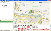
Garmin nRoute is the popular piece of software that allows for auto-routing on a laptop computer with a Garmin GPS unit.
Category: Internet / Misc. Plugins
nRoute is a powerful and feature-rich tool that supports waypoints, tracks, points of interest, addresses and more, but is primarily for navigating and tracking in real time.
nRoute is also compatible with most Garmin units.
Publisher: Garmin Ltd or its subsidiaries, License: Freeware, Price: USD $0.00, File Size: 105.4 MB
Platform: Windows
The Garmin Communicator Plugin is a free Internet browser plugin that transfers data between your Garmin GPS device and your computer.
For example, with the Garmin Communicator Plugin you can add the maps you purchase at Garmin.com to your device. Or, you can upload your training data from your Garmin fitness device to Garmin Connect™.
Category: Internet / Communications
Publisher: Garmin Ltd or its subsidiaries, License: Freeware, Price: USD $0.00, File Size: 14.2 MB
Platform: Windows
Keep track of discount Garmin GPS deals on with this Firefox toolbar.
Keep track of discount Garmin GPS deals on with this Firefox toolbar.compare and buy all the latest Garmin satellite navigation systems. If you want a discount Garmin GPS system this is the Firefox toolbar to use. We also provide information on the latest offers, price cuts and discount voucher codes to help you buy the latest Garmin GPS at the cheapest price...
Category: Internet / Browsers
Publisher: Discount Garmin GPS, License: Freeware, Price: USD $0.00, File Size: 1.1 MB
Platform: Windows
Upgrading software for your Garmin GPS just got easier thanks to WebUpdater—Garmin's free new application that automatically detects and installs the most recent version of operating software for your compatible Garmin GPS. WebUpdater's simple interface makes it easy to upgrade your operating software. Just connect your Garmin GPS to your computer,...
Category: Utilities / Misc. Utilities
Publisher: Garmin Ltd or its subsidiaries, License: Freeware, Price: USD $0.00, File Size: 7.2 MB
Platform: Windows
Free Fleet Management Windows-Desktop standalone application work with Garmin and A1.
Free Fleet Management Windows-Desktop standalone application work with Garmin and A1.You can send messages and STOPs (destinations on Garmin MAP) with short message to driver, direct to his Garmin navigation device.Driver can send message to you using touch-screen keyboard. Ideal for taxi / delivery dispatch. Lowest communication cost by GPRS. Tracking vehicles at map at...
Category: Security & Privacy / Other
Publisher: Clarion LLC, License: Freeware, Price: USD $0.00, File Size: 3.4 MB
Platform: Windows
MarineUpdater is a Windows-based PC application which works in conjunction with a Garmin USB card reader, a Garmin data card, and an Internet connection to generate software update cards for your fixed-mount Garmin marine products. Products which support MarineUpdater will program a data card with information about your Garmin marine product and other Garmin...
Category: Home & Education / Miscellaneous
Publisher: Garmin Ltd or its subsidiaries, License: Freeware, Price: USD $0.00, File Size: 2.0 MB
Platform: Windows
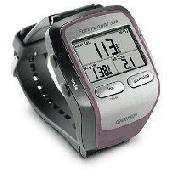
Screensaver with a Garmin Forerunner theme. .
Screensaver with a Garmin Forerunner theme.
Category: Desktop Enhancements / Screensavers
Publisher: Garmin Forerunner 305, License: Freeware, Price: USD $0.00, File Size: 1.5 MB
Platform: Windows
FREE GPS Software for your Garmin, Magellan or Lowrance GPS.
FREE GPS Software for your Garmin, Magellan or Lowrance GPS.
EasyGPS is the fast and easy way to upload and download waypoints, routes, and tracks between your Windows computer and your Garmin, Magellan, or Lowrance GPS. EasyGPS lists all of your waypoints on the left side of the screen, and shows a plot of your GPS data on the right. Use EasyGPS to back up and organize...
Category: Internet / Communications
Publisher: TopoGrafix, License: Freeware, Price: USD $0.00, File Size: 3.9 MB
Platform: Windows

OkCustomMap is a software to produce Garmin Custom Maps.
OkCustomMap is a software to produce Garmin Custom Maps.
Supports many map formats:
- OkMap
- Ecw
- GeoTiff
- World files
- OziExplorer
- GpsTuner
You can customize:
- The quality of the output JPEG images (0=Bad, 100=Good)
- The KML transparency (0=Transparent, 255=Opaque)
- The KML draw order (0=Invisible, 1-49=Under the vectorial data,...
Category: Business & Finance / Applications
Publisher: Gian Paolo Saliola, License: Freeware, Price: USD $0.00, File Size: 3.2 MB
Platform: Windows
Garmin MapConverter was developed to be a tool that will allow you to convert maps and unlock codes on your Windows PC to the Macintosh format. Transferred maps will remain fully accessible on your Windows PC. It works on Windows XP, Windows Vista, Windows 7.
Category: Utilities / Misc. Utilities
Publisher: Garmin Ltd or its subsidiaries, License: Freeware, Price: USD $0.00, File Size: 2.6 MB
Platform: Windows
Turtle Sport is a free software developed to communicate with Garmin fitness products (forerunner and edge).
Turtle Sport retrieves yours training sessions from your Garmin and it makes diagram. You can also order your training sessions by category and training mode. With Turtle Sport, it is also possible to map your GPS training paths in Google Earth.
Athlete...
Category: Home & Education / Miscellaneous
Publisher: TurtleSport, License: Freeware, Price: USD $0.00, File Size: 6.9 MB
Platform: Windows
Palm Desktop for Garmin iQue 3600 is one of the first PDAs to offer built-in GPS, as opposed to the jackets often used with other models.
Mapping integrates well - you can add a location to any address book entry, for example - but you can only route to an address from your present location, not from one distant one to another.
Category: Multimedia & Design / Multimedia App's
Publisher: Garmin Ltd or its subsidiaries, License: Freeware, Price: USD $0.00, File Size: 11.7 MB
Platform: Windows
This software will not work unless you already own a MapSource product.
This software will not work unless you already own a MapSource product.
Main Features:
- Improved memory issues when running on Windows 7.
- Improved map projection for many map products.
- Changed mouse-wheel functionality to zoom in and out.
- Added support for enhanced map security.
- Fixed unlocking issue.
...
Category: Home & Education / Miscellaneous
Publisher: Garmin Ltd or its subsidiaries, License: Freeware, Price: USD $0.00, File Size: 8.4 MB
Platform: Windows
CS1300 tools is a software that helps students learn informatics.
CS1300 tools is a software that helps students learn informatics. The package includes:
- Minimalist GNU Windows 32 Tools with
- g (Version 3.3.1),
- Gdb (Version 5.2.1),
- make (Version 3.8),
- win32 api library (Version 2.5),
- and more from bintools (2.13.90) and elsewhere: addr2line, ar, as, awk, bison, c , c filt, cc, cmp, dlltool, echo,...
Category: Home & Education / Teaching Tools
Publisher: Colorado, License: Freeware, Price: USD $0.00, File Size: 58.3 MB
Platform: Windows
GeePeeEx Editor is specifically designed to produce and edit GPX files destined for Garmin's® Automotive Satnav (GPSr) systems. These files can be used as input to Garmin's® POI Loader to produce enhanced Custom POI's (Points of Interest).
Convert CSV files to GPX. Optionally and uniquely, GeePeeEx Editor will search for valid telephone numbers...
Category: Audio / Rippers & Encoders
Publisher: Them, License: Freeware, Price: USD $0.00, File Size: 2.6 MB
Platform: Windows
KMLCSV Converter is a tool that enables you to convert the KML file generated from Google Earth (free version) into a formatted CSV file (and vice versa). This CSV file can then be uploaded into your Garmin GPS by using Garmin POI Loader, which can be downloaded for free. This allows you to plot all the custom point of interests (POI) with Google Earth first. Then, you can...
Category: Business & Finance / Calculators
Publisher: Choon-Chern Lim, License: Freeware, Price: USD $0.00, File Size: 2.3 MB
Platform: Windows
 Freeware
org, uses file and position names that suit to the display of the TomTom Rider, uses file, route and position names that suit to the display of the Map&Guide Motorrad Tourenplaner, remembers language, paths, window size and position. . .
Category: Business & Finance / Conversion Applications
Publisher: Christian Pesch, License: Freeware, Price: USD $0.00, File Size: 6.6 MB
Platform: Windows, Mac, Linux, Solaris, FreeBSD, OpenBSD, Java
DNRGarmin is a smart tool used to directly transfer data between Garmin GPS handheld receivers and various GIS software packages.
DNRGarmin was built to provide users the ability to directly transfer data between Garmin GPS handheld receivers and various GIS software packages. Using DNRGarmin a user can use point features (graphics or shapefile) and upload them to the...
Category: Utilities / Misc. Utilities
Publisher: GIS Section, Minnesota Department of Natural Resources, License: Freeware, Price: USD $0.00, File Size: 11.3 MB
Platform: Windows
AdriaROUTE Lite version of map is made without Garmin NT technology so users with older device can use AdriaROUTE map. Some of devices that not support NT technology are: (eTrex Legend, eTrex Vista, eTrex LegendC, eTrex VistaC, GPSMAP 60C, GPSMAP 60CS, CPSMAP 76C, GPSMAP 76CS, iQue3600; iQue M4; iQue M5..).
Category: Utilities / Misc. Utilities
Publisher: Navigo Sistem d.o.o., License: Freeware, Price: USD $0.00, File Size: 149.6 MB
Platform: Windows
The Windows PC shareware program for Garmin and Magellan GPS receivers.
The Windows PC shareware program for Garmin and Magellan GPS receivers.
Main Features:
- transfer your waypoints, routes, and tracks from and to the GPS receiver, and save it on your computer disk
- review your waypoints
- enter and edit your waypoints
- define your routes and get the estimated traveling time
- review and edit your...
Category: Home & Education / Miscellaneous
Publisher: Heinrich Pfeifer, License: Freeware, Price: USD $0.00, File Size: 2.9 MB
Platform: Windows
Oasis montaj Viewer is a easy-to-use program that allows anyone to view, share, and print published Geosoft grid (.grd) and Database (.Gdb) files. The viewer can also be used to convert grids and images to a variety of supported data formats, including AutoCAD, ArcVIew, ER Mapper, TIF, and many more.
Category: Multimedia & Design / Graphics Viewers
Publisher: GEOSoft, License: Freeware, Price: USD $0.00, File Size: 137.4 MB
Platform: Windows
Northwest Trails is a mapset of trails designed for upload to any map-enabled Garmin GPS receiver.
Northwest Trails is a mapset of trails designed for upload to any map-enabled Garmin GPS receiver. It is more than just a mapset, though; it is also a community effort initiated to record and collect GPS data for trails in the Northwest (Washington, Idaho, Oregon, Montana, Wyoming, Alaska, British Columbia and Alberta) and provide that data for general public use.
The mapset...
Category: Internet / Misc. Plugins
Publisher: Jon F. Stanley, License: Freeware, Price: USD $0.00, File Size: 31.7 MB
Platform: Windows
GeoVisu is a program that displays georeferenced data (images, graphics) and downloads data recorded by some GPS devices.
GeoVisu has a "Moving map" navigation function, which can be used with any NMEA 0183 compatible or Garmin USB GPS device.
Main features:
- Displays georeferenced image formats : GeoTiff, ECW and ECWP, MrSID, OziExplorer...
Category: Multimedia & Design / Graphics Viewers
Publisher: GeoVisu, License: Freeware, Price: USD $0.00, File Size: 1.7 MB
Platform: Windows
Bloodshed Dev-C is a full-featured Integrated Development Environment (IDE) for the C/C programming language. It uses Mingw port of GCC (GNU Compiler Collection) as it's compiler. Dev-C can also be used in combination with Cygwin or any other GCC based compiler.
It supports GCC-based compilers.
You can integrate debugging (using Gdb)
Category: Software Development / Misc. Programming
Publisher: Bloodshed Software, License: Freeware, Price: USD $0.00, File Size: 8.9 MB
Platform: Windows
Portable GPS Navigation toolbar for Internet Explorer.
Portable GPS Navigation toolbar for Internet Explorer. Find portable gps units for your car, truck or minvan from top name brands including Tom Tom, Magellan and Garmin. Discover the world of eBay and shop for portable gps navigation systems directly from your browser toolbar.
Category: Internet / Browsers
Publisher: Portable GPS Navigation System, License: Freeware, Price: USD $0.00, File Size: 1.1 MB
Platform: Windows
Do you need to design, visualize or document your database?
Do you need to design, visualize or document your Database?ModelRight 3 can reverse engineer your existing Database to get a graphical view of it, generate all the SQL statements to create the Database, or synchronize your Database model with the Database to keep your design up to date. Do you need to control the most detailed aspects of your physical...
Category: Business & Finance / Database Management
Publisher: ModelRight, Inc., License: Freeware, Price: USD $0.00, File Size: 26.0 MB
Platform: Windows
This mapset contains topographic, hydro, road, trail, POI, and public land data for the state of Montana. Topo lines dissipate quicker as zoom scale increases. Much improved over the Garmin 24K series when zoomed out. Specialized Night Mode colors to maximize viewability while retaining useful landowner colorization scheme.
Category: Home & Education / Miscellaneous
Publisher: Northwest Environmental Services, License: Freeware, Price: USD $0.00, File Size: 421.3 MB
Platform: Windows
Database Workbench offers a single development environment for developing with multiple Database engines.
With Database engine specific functionality, powerful tools and a consistent, clear and intuitive user interface, Database Workbench will increase your productivity from the moment you start using it.
Database Workbench offers the same...
Category: Business & Finance / Database Management
Publisher: Upscene Productions, License: Freeware, Price: USD $0.00, File Size: 17.8 MB
Platform: Windows
MyGPS is a Freeware software for the creation and the management of longitude and latitude calibrated maps.
The software can define points of interest obtaining their coordinates (waypoints), can create routes (routepoints), can visualize track paths (trackpoints).
Using a serial link, points routes and tracks can be shared with "eTrex" and "Geko" Garmin...
Category: Home & Education / Miscellaneous
Publisher: GPSInfo, License: Freeware, Price: USD $0.00, File Size: 2.3 MB
Platform: Windows
Oracle Database 11g Express Edition (Oracle Database XE) is an entry-level, small-footprint Database based on the Oracle Database 11g Release 2 code base. It's free to develop, deploy, and distribute; also it is fast to download and simple to administer.
Oracle Database XE is a great starter Database for:
- Developers working on PHP,...
Category: Web Authoring / Web Design Utilities
Publisher: Oracle Corporation, License: Freeware, Price: USD $0.00, File Size: 312.2 MB
Platform: Windows
DJGPP is a complete 32-bit C/C development system for Intel 80386 (and higher) PCs running DOS.
DJGPP is a complete 32-bit C/C development system for Intel 80386 (and higher) PCs running DOS. It includes ports of many GNU development utilities. The development tools require a 80386 or newer computer to run, as do the programs they produce. In most cases, the programs it produces can be sold commercially without license or royalties.
The purpose of DJGPP is to give you the...
Category: Software Development / Misc. Programming
Publisher: DJ Delorie, License: Freeware, Price: USD $0.00, File Size: 94.4 KB
Platform: Windows
The SRS Database Conversion program is a utility which allows the user to convert the data contained in an existing SRS-formatted Database from a version 5 Database into a version 6 Database. This conversion is valid for any Database produced by the SpaceQry, or SpaceCap software packages, as well as the SRS and SpaceIFIC databases supplied by the...
Category: Utilities / Misc. Utilities
Publisher: International Telecommunication Union, License: Freeware, Price: USD $0.00, File Size: 4.9 MB
Platform: Windows
QuakeMap is a powerful GPS/mapping program for your Windows computer.
QuakeMap is a powerful GPS/mapping program for your Windows computer. It can be downloaded here for free. The trial mode allows you to use most features indefinitely. When you need to unlock certain powerful features, a License Key can be ordered here. QuakeMap is designed for ease of use. It eatures intuitive user interface, supports most popular Garmin and Magellan receivers, reads and...
Category: Utilities / Misc. Utilities
Publisher: quakemap.com, License: Freeware, Price: USD $0.00, File Size: 821.2 KB
Platform: Windows
SiteMech Database Manager is a part of SiteMech Web Development Framework.
SiteMech Database Manager is a part of SiteMech Web Development Framework. This is a small and useful tool for backup and exchange data between Microsoft SQL Server and MySQL databases. It allows to export entire Database or particular tables to XML file. Later you can import saved file to a local or remote Database. The software allows direct data transfer between MSSQL...
Category: Utilities / Backup
Publisher: SiteMechanics, License: Freeware, Price: USD $0.00, File Size: 1.1 MB
Platform: Windows
Amontec sdk4arm is a complete Software Development Kit for ARM processors based on GNU tools ( full sources), but it comes pre-compiled for Win32. Using the source of the sdk4arm, you may build your sdk4arm for Linux.
Amontec sdk4arm does not need Cygwin to run the GNUARM toolchain.
Amontec sdk4arm includes :
- a IDE Viewer : Eclipse platform / Embedded...
Category: Software Development / Misc. Programming
Publisher: Amontec, License: Freeware, Price: USD $0.00, File Size: 98.4 MB
Platform: Windows
The Universal Database Converter transfers complete Database data structures, data repositories, and indices from one Database system to another. Table relationships with primary and foreign keys are also taken into account and transferred into the target system. Thus the Universal Database Converter enables flexible and adaptive handling of various...
Category: Business & Finance
Publisher: optadat@.com, License: Freeware, Price: USD $0.00, File Size: 2.9 MB
Platform: Windows
Northwest Topos is a mapset containing contours, hydrology, roads, trails, points of interest and more for the State of Washington and adjoining regions. It is designed for upload to any map-enabled Garmin GPS receiver.
As of this release, it covers all of the State of Washington along with the North Idaho Panhandle, much of northern and western Oregon, the areas around...
Category: Home & Education / Miscellaneous
Publisher: Jon F. Stanley, License: Freeware, Price: USD $0.00, File Size: 820.2 MB
Platform: Windows

The Approach displays and updates your exact position on stunningly detailed, preloaded course maps throughout the United States, and many European and other countries. Click to see Garmin's current Approach G5 course listing. Approach's highly sensitive GPS receiver pinpoints your position and removes guesswork from your game. And as you move, Approach automatically updates your...
Category: Home & Education / Miscellaneous
Publisher: GeminiPress Publishing, License: Freeware, Price: USD $0.00, File Size: 45.3 MB
Platform: Windows, Mac, Palm
SQL Database Studio is modern professional client for Microsoft SQL Server. It enables you to effectively work with SQL Database. SQL Database Studio contains advanced features such as Database comparison, GPS visualization, table lookups, filters, dbshell extension and also features for basic Database operations.
Category: Business & Finance / Database Management
Publisher: SQL Database Studio, License: Freeware, Price: USD $0.00, File Size: 6.0 MB
Platform: Windows
This program converts from GPX format to CSV format or vice versa.
This program converts from GPX format to CSV format or vice versa. You can create waypoints in MapSource and then convert them to POI (CSV) files for download or sharing with others.
You can also convert POI (CSV) files that others have created, and then edit them in MapSource. Now that the Garmin POI loader supports GPX files, GPXtoPOI's most important role is CSV to...
Category: Business & Finance / Calculators
Publisher: MasterClass, License: Freeware, Price: USD $0.00, File Size: 1.4 MB
Platform: Windows
Get free SQL Server Database viewer as a tool to read SQL Database which is corrupt and damaged.
Get free SQL Server Database viewer as a tool to read SQL Database which is corrupt and damaged. Advanced Free SQL Server Database viewer tool helps you to view corrupt MDF Database and deleted items like: stored procedures, tables, triggers, rules and functions etc. of SQL Server 2000, SQL Server 2005 and SQL Server. Know how to read MDF files by using SQL...
Category: Utilities / Backup
Publisher: Free SQL Server Database Viewer, License: Freeware, Price: USD $0.00, File Size: 1.6 MB
Platform: Windows
Axisbase is database system - consisting of an internet database server and a desktop tool.
Axisbase is Database system - consisting of an internet Database server and a desktop tool. You can use it to build a system to manage whatever kind of information your business deals with. For example, it could track sales made on a web site, and perform order fulfillment from your office. Axisbase is comparable to other Database tools like Filemaker, Microsoft Access, or...
Category: Business & Finance / Database Management
Publisher: Ian Ford, consultant, License: Freeware, Price: USD $0.00, File Size: 3.5 MB
Platform: Windows
The GPS TrackManager is an application for planning routes and managing routes, waypoints and trackpoints.
The application support functions such as: open and save trackpoints files in various formats (GPX, Ozi Trackpoint file, Ozi Waypoint file, NMEA log, EasyGPS file), transmit Trackpoints, Waypoints and Routes to Garmin GPS receivers (Geko 201, GPSmap 60C), saves trackpoints as...
Category: Internet / Communications
Publisher: Frank Hamaekers, Write4u, License: Freeware, Price: USD $0.00, File Size: 4.8 MB
Platform: Windows
World Cities Database with Latitude Longitude and time zone Info Global World
World Cities Database with Latitude Longitude and time zone Info Global World Database viewer program is a useful utility which help you to: 1.Display all information about any city (location) in the Database and search into it, 2.Export the Database in Text Format so you can use it easily with Major Database Systems SQL Server, Oracle, Access, MySQL...
Category: Software Development
Publisher: geographicdb, License: Freeware, Price: USD $0.00, File Size: 35.2 MB
Platform: Windows
Freeware
Using SQLScriptGenerator you can connect to your local or remove SQL Server and generate T-SQL script of the whole Database or just Database structure or just data or specific Database objects. In the result it generates one or several *.sql files with CREATE, INSERT T-SQL statements that recreate Database objects you've selected. See features for supported...
Category: Utilities / Backup
Publisher: Pranas.NET, License: Freeware, Price: USD $0.00, File Size: 410.2 KB
Platform: Windows

SysTools MDF Viewer Software is the single solution to the most common queries like: how to open SQL Database file?, how to read SQL Database?, how to read MDF files? etc. SQL Database Reader Tool to read SQL Database, open SQL Database file and view all the corrupted SQL Database without any cost. AS per your requirement SysTools provide an effective...
Category: Utilities / Backup
Publisher: Tool to Read SQL Database, License: Freeware, Price: USD $0.00, File Size: 1.6 MB
Platform: Windows
Using SQLScriptGenerator you can connect to your local or remove SQL Server and generate T-SQL script of the whole Database or just Database structure or just data or specific Database objects. In the result it generates one or several *.sql files with CREATE, INSERT T-SQL statements that recreate Database objects you've selected. See features for supported...
Category: Security & Privacy / Firewall
Publisher: Pranas.NET, License: Freeware, Price: USD $0.00, File Size: 410.0 KB
Platform: Windows
Wascana is based on the MinGW (Minimal Gnu for Windows) gcc and g compilers from tdragon.
Wascana is based on the MinGW (Minimal Gnu for Windows) gcc and g compilers from tdragon.net and the binutils and msys from mingw.org. Wascana will use CDT's new internal debugger (EDC) instead of Gdb.
To complete the IDE, SDKs (libraries and headers) are included to support Windows development. These packages mainly come from the Fedora mingw cross development packages....
Category: Software Development / Misc. Programming
Publisher: cdtantl, License: Freeware, Price: USD $0.00, File Size: 148.3 MB
Platform: Windows
Freeware
Reportizer Viewer is a free Database reporting utility. It allows previewing, printing, or exporting Database reports, created in Database Tour Pro or Reportizer. Works with relational databases (via ADO or BDE) and with file system. Reports can be exported to HTML, XLS, TXT, JPEG, GIF, PNG, BMP, or STT (static report) file. The most important operations can be performed...
Category: Business & Finance / Database Management
Publisher: Vitaliy Levchenko, License: Freeware, Price: USD $0.00, File Size: 1.1 MB
Platform: Windows
DBTree is a cross-platform (both database and operating system) general purpose database query tool.
DBTree is a cross-platform (both Database and operating system) general purpose Database query tool. Some of the primary features of DBTree are a tabbed interface which allows you multi-Database connectivity and multiple Workbooks per connection. A Workbo
Category: Software Development / Databases & Networks
Publisher: kccoder.com, License: Freeware, Price: USD $0.00, File Size: 1.1 MB
Platform: Windows, Mac, Linux, Solaris