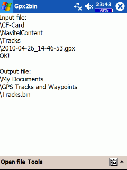
Free Downloads: Gps Logger Nmea
License: All | Free
The program accepts NMEA GPS sentences from most GPS receivers that connect to a USB port.
The program accepts Nmea Gps sentences from most Gps receivers that connect to a USB port.
The program can display satellite images of waypoint locations on the track plotter.
Is a free software for recording , monitoring and plotting Gps data, very useful and very easy.
Category: Home & Education / Miscellaneous
Publisher: Club Cruceros de La Paz A.C., License: Freeware, Price: USD $0.00, File Size: 10.6 MB
Platform: Windows
My Gps Logger 1.01 is a program designed to be used with My Fuel Tax 4.0. With My Gps Logger you can log all the locations where your truck has been to a monthly data file. This data file can later be imported into My Fuel Tax 4.0 by calculating the miles in state using Microsoftâ Mappoint. This is what you will need to use My Gps Logger with My...
Category: Home & Education / Miscellaneous
Publisher: Spinnaker Software Solutions, License: Freeware, Price: USD $0.00, File Size: 477.7 KB
Platform: Windows
GPSsim application is software based GPS device simulator.
GPSsim application is software based Gps device simulator.
GPSsim plays back Nmea data that was saved previously. It is also possible to generate custom Nmea data.
GPSsim allows you to test various PC-based navigation programs as well as use it as data Logger application to track vehicle location
Category: Home & Education / Miscellaneous
Publisher: HL-soft, License: Freeware, Price: USD $0.00, File Size: 2.8 MB
Platform: Windows

Gps Clock Software is a freeware utility that runs on any Windows NT/2000/XP/2003 workstation or server. The software polls time from a standard Nmea Gps time receiver connected to the host PC's serial port and optionally allows time to be synchronised on the host PC. The Gps clock utility polls GPRMC messages from a standard Nmea Gps time receiver....
Category: Utilities
Publisher: ntp time server, License: Freeware, Price: USD $0.00, File Size: 1.9 MB
Platform: Windows
GPSCommunicator is a FREE utility to visually represent NMEA GPS position data in realtime.
GPSCommunicator is a FREE utility to visually represent Nmea Gps position data in realtime. It works with Nmea 0183 Gps receivers connected via a serial port. GPSCommunicator has the following features:
- Vessel position display over moving map.
- User selectable maps.
- Create and save Waypoints.
- Graphical Gps data display
-...
Category: Internet / Misc. Plugins
Publisher: Panazzolo.Com, License: Freeware, Price: USD $0.00, File Size: 772.5 KB
Platform: Windows
Kinomap Gps File Fixer allows you to process some treatments on Gps file:
- convert almost any Gps file to standard Nmea 0183, compatible with Kinomap
- fill the gaps between points when your file is not 1Hertz: the extra point will be recreated by interpolation
- cut a long file in which there are loops of data (example: race) in several parts
Category: Home & Education / Miscellaneous
Publisher: ExcelLance, License: Freeware, Price: USD $0.00, File Size: 19.6 MB
Platform: Windows

HS Gps is a software library (with full C source code) which provides access to a Nmea-183 compliant Gps receiver via a serial communications port, decoding Nmea sentences: $GPGGA, $GPGSA, $GPGSV, $GPGLL, $GPRMC and $GPVTG. Decoded parameters include: time, date, position, altitude, speed, course and heading, according to standard - Nmea-183 (National Marine...
Category: Software Development
Publisher: Hillstone Software, License: Freeware, Price: USD $0.00, File Size: 309.3 KB
Platform: Windows
A program to convert GPS-track of *. gpx, *.
mps, *. plt or *. nmea format to Navitel Tracks.
Category: Home & Education / Sports
Publisher: DXsoft, License: Freeware, Price: USD $0.00, File Size: 31.6 KB
Platform: Windows
Have a Gps and a laptop? Use this to find your way. Make patterns or a trail to share with others. When the application starts, you may pick your area of operations - be it North America, South America, Europe and Asia, or Australia. Your quadrant is determined by where you are in relation to the Equator and the Prime Meridian. Tracking of your position is automatically enabled when the...
Category: Home & Education / Miscellaneous
Publisher: LogicAll Solutions, LLC, License: Freeware, Price: USD $0.00, File Size: 4.6 MB
Platform: Windows
The fast track to GPS success.
The fast track to Gps success. The Linx MDEV-Gps-SR contains everything needed to rapidly evaluate the SR Series Gps modules and implement them in record time. This all-inclusive Master Development System features a pre-assembled development board with an on-board OLED display for standalone testing. The system can also be attached to a PC via USB and operated using the...
Category: Software Development / Misc. Programming
Publisher: Linx Technologies, Inc., License: Freeware, Price: USD $0.00, File Size: 98.5 MB
Platform: Windows
Gps log-maker. Software creates *.plt track file, *.rte route file and, optionally, Nmea-log file.
Category: Internet / SMS
Publisher: dxsoft.com, License: Freeware, Price: USD $0.00, File Size: 85.8 KB
Platform: Unknown
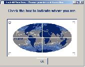
Have a Gps and a laptop? Use this to find your way. Make patterns or a trail to share with others. When the application starts, you may pick your area of operations - be it North America, South America, Europe and Asia, or Australia. Your quadrant is determined by where you are in relation to the Equator and the Prime Meridian. Tracking of your position is automatically enabled when the...
Category: Home & Education / Miscellaneous
Publisher: LogicAll Solutions, LLC, License: Freeware, Price: USD $0.00, File Size: 4.6 MB
Platform: Windows
Diffusion is done by sending sentences at format NMEA 0183 using UDP protocol .
Diffusion is done by sending sentences at format Nmea 0183 using UDP protocol .Diffused data come either from a Gps receiver or source issuing on UDP in real time navigation mode, either from a replayed file. In case of replay, position and speed settings are modifiable.GpsDiffuser is at least compatible with itself, GeoVisu and GpsGate.
Category: Utilities / Misc. Utilities
Publisher: GeoVisu team, License: Freeware, Price: USD $0.00, File Size: 1.7 MB
Platform: Windows
The Gps TrackManager is an application for planning routes and managing routes, waypoints and trackpoints.
The application support functions such as: open and save trackpoints files in various formats (GPX, Ozi Trackpoint file, Ozi Waypoint file, Nmea log, EasyGPS file), transmit Trackpoints, Waypoints and Routes to Garmin Gps receivers (Geko 201, GPSmap 60C), saves...
Category: Internet / Communications
Publisher: Frank Hamaekers, Write4u, License: Freeware, Price: USD $0.00, File Size: 4.8 MB
Platform: Windows

MB-GPS2KML converts a GPS log file (in plain NMEA format) to a KML file (placemark file for Google Earth) and opens this file in Google Earth. Velocity, number of satellites and HDOP are interpreted as height, color and size of the icons.
Category: Home & Education
Publisher: Markus Bader, License: Freeware, Price: USD $0.00, File Size: 441.4 KB
Platform: Windows
Yet another tool to read and convert Gps logs from Royaltek RGM-3800 and RBT-2300 (using serial communication), from RBT-3000 (using files), from Nmea logs files (comming from AMOD 3080 datalogger for example). Free download and easy to install. Enjoy.
Category: Utilities / Misc. Utilities
Publisher: eXtraGPS, License: Freeware, Price: USD $0.00, File Size: 2.5 MB
Platform: Windows
VisualGPS incorporates many advanced features found in professional programs.
VisualGPS incorporates many advanced features found in professional programs. Its sole purpose is to display graphically specific Nmea 0183 sentences and show the effects of selective availability (SA).
Main Features:
- Azimuth and Elevation Graph - View all satellites that are in view. Each satellite identifies its pseudo random number (PRN) and its azimuth and...
Category: Home & Education / Miscellaneous
Publisher: VisualGPSLLC, License: Freeware, Price: USD $0.00, File Size: 1.7 MB
Platform: Windows
With our locr PC software "locr Gps Photo for Windows" you can manage to automatically geotag numerous photos simultaneously. You just require a digital camera, a Gps data Logger and the application "locr Gps Photo for Windows".
There are two ways to geotag your photos: The photos can be tagged manually or automatically. For automatic...
Category: Multimedia & Design / Multimedia App's
Publisher: locr, License: Freeware, Price: USD $0.00, File Size: 490.8 KB
Platform: Windows
RS232 Data Logger by Eltima Software is an Open Source application which allows you to redirect all communication data from RS232 compliant serial port device into a text file for further analysis. RS232 Data Logger redirects data from any available serial port (doesn't matter whether it is virtual or real one) and works under Virtual Machine (VMWare). You can gather data from...
Category: Utilities
Publisher: ELTIMA Software GmbH, License: Freeware, Price: USD $0.00, File Size: 745.9 KB
Platform: Windows
GeoVisu is a program that displays georeferenced data (images, graphics) and downloads data recorded by some Gps devices.
GeoVisu has a "Moving map" navigation function, which can be used with any Nmea 0183 compatible or Garmin USB Gps device.
Main features:
- Displays georeferenced image formats : GeoTiff, ECW and ECWP,...
Category: Multimedia & Design / Graphics Viewers
Publisher: GeoVisu, License: Freeware, Price: USD $0.00, File Size: 1.7 MB
Platform: Windows
FREE GPS Software for your Garmin, Magellan or Lowrance GPS.
FREE Gps Software for your Garmin, Magellan or Lowrance Gps.
EasyGPS is the fast and easy way to upload and download waypoints, routes, and tracks between your Windows computer and your Garmin, Magellan, or Lowrance Gps. EasyGPS lists all of your waypoints on the left side of the screen, and shows a plot of your Gps data on the right. Use EasyGPS to back up...
Category: Internet / Communications
Publisher: TopoGrafix, License: Freeware, Price: USD $0.00, File Size: 3.9 MB
Platform: Windows
IPaNema reads any Nmea data from one of the serial ports (Com1-15) and delivers the Nmea data to any user selectable port and IP address using the UDP protocol acting as UDP server.
It can also act as an UDP client, receiving Nmea sentences wrapped in UDP packets and outputs these to a serial communications port
Category: Internet / Misc. Plugins
Publisher: Sailsoft, License: Freeware, Price: USD $0.00, File Size: 263.3 KB
Platform: Windows
Golf GPS Devices toolbar for internet explorer.
Golf Gps Devices toolbar for internet explorer. Find golf Gps devices are great bargain prices. We have all the latest golf Gps devices for sale both new and used. Whether you're looking for the iGolf, Golf Buddy, GolfLogix, SonoCaddie, or SkyCaddie, you can find it here along with their accessories. We are always searching our networks to bring you the best deals on golf...
Category: Internet / Browsers
Publisher: Golf GPS Devices, License: Freeware, Price: USD $0.00, File Size: 1.1 MB
Platform: Windows
Are you looking for a Gps tracking system or a Gps tracker but haven't found the one that is ideal for you? Then, look no further as our site has the best deals and information about the kind of Gps tracker you should buy.
Category: Security & Privacy / Other
Publisher: Top GPS Tracking Srl., License: Freeware, Price: USD $0.00, File Size: 722.0 KB
Platform: Windows
Portable GPS Navigation toolbar for Internet Explorer.
Portable Gps Navigation toolbar for Internet Explorer. Find portable Gps units for your car, truck or minvan from top name brands including Tom Tom, Magellan and Garmin. Discover the world of eBay and shop for portable Gps navigation systems directly from your browser toolbar.
Category: Internet / Browsers
Publisher: Portable GPS Navigation System, License: Freeware, Price: USD $0.00, File Size: 1.1 MB
Platform: Windows
Winsol allows you to capture and analyze the measurements from the data Logger (Bootloader, D-Logger). To analyze the recorded data Winsol provides a graphical representation of the readings during the day. Likewise, the recorded values could be exported to a csv-file to be able to process and create your own statistics. Furthermore Winsol supports the management and analysis of...
Category: Utilities / Misc. Utilities
Publisher: Technische Alternative, License: Freeware, Price: USD $0.00, File Size: 69.6 KB
Platform: Windows
Adiscon Logger is an UNIX-like Logger command line tool for Windows. It is a re-write of the UNIX Logger tool with enhanced functionality. All the popular UNIX options are supported. Also, it supports reliable syslog transport via RFC 3195 and plain tcp as found in other Adiscon's products as well as some others like syslog-ng. In addition to that, it includes options...
Category: Utilities
Publisher: Adiscon GmbH, License: Freeware, Price: USD $0.00, File Size: 100.0 KB
Platform: Windows
GPS Tuner was first launched in 2003.
Gps Tuner was first launched in 2003. Success followed introduction shortly. Over the years it became a best-selling favourite Gps software among off-roaders as a reliable, versatile feature-packed application suiting the needs of outdoor enthusiasts and professional off-road users alike. After five years of continuous development of previous Gps Tuner versions Gps...
Category: Web Authoring / Web Design Utilities
Publisher: GPS Tuner Ltd., License: Freeware, Price: USD $0.00, File Size: 4.5 MB
Platform: Windows
N2KBuilder software is a powerful, free PC-based tool for designing and verifying the integrity of Nmea 2000 networks.
The N2KBuilder software, when installed on a Windows PC and used as part of an integrated design workflow can be used to plan, document, and validate the design of complex Nmea 2000 networks.
In addition, N2KBuilder will directly produce...
Category: Internet / Misc. Plugins
Publisher: Maretron, LLP, License: Freeware, Price: USD $0.00, File Size: 10.0 MB
Platform: Windows
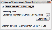
Save all incoming and outgoing Internet traffic on the disk with Free Internet Content Logger.
- Do you want to know what kind of information programs send from your computer to their owners? - Are you a network or system administrator and need to save all incoming and outgoing Internet traffic on the hard disk in order to measure the security risks? - Are you are a software developer creating your own Internet releted software programs, and need to capture all the incoming and...
Category: Internet
Publisher: ContentLogger.com, License: Freeware, Price: USD $0.00, File Size: 469.5 KB
Platform: Windows
The Gps Detector software is used to update the Gps detector's database , updating maps , routes and camera locations . The device itself is based on pre-installed Gps coordinates, the device can indicate various road hazards like: Fixed cameras, Red light speed cameras and bus lane cameras, Usual speed measurement places and dangerous zones.
Category: Business & Finance / Business Finance
Publisher: Euro Noliker Kft., License: Freeware, Price: USD $0.00, File Size: 5.5 MB
Platform: Windows
The Gps Controller software is a free program designed to allow you to configure a range of Gps receivers. There are versions that run on Windows desktop computers, or Windows Mobile devices.
Before downloading the software, it recommend downloading and reading the documentation to confirm which version you need.
Category: Home & Education / Miscellaneous
Publisher: Trimble Navigation, License: Freeware, Price: USD $0.00, File Size: 30.9 MB
Platform: Windows
Temperature Logger is a software tool which allows you to install the Temperature Logging System.
Temperature Logger is a software tool which allows you to install the Temperature Logging System.
As soon as the installation of the driver is finished, you can start the Temperature logging
system application. You can start the program through the main menu: Start->All programs->Temperature Logger->Temperature Logger.
On the left side...
Category: Utilities / Misc. Utilities
Publisher: Arexx Engineering, License: Freeware, Price: USD $0.00, File Size: 15.4 MB
Platform: Windows
GPS-CCD:is a novel computational program for the
Prediction of Calpain Cleavage Sites.
Gps-CCD:is a novel computational program for the
Prediction of Calpain Cleavage Sites.
The online service and local packages of Gps-CCD 1.0 were
implemented in JAVA/. For the online service, we tested the Gps-CCD1.0 on a variety of internet browsers, including Internet Explorer 6.0, Netscape Browser 8.1.3 and Firefox 2 under the Windows XPOperating System...
Category: Web Authoring / JavaScript
Publisher: The CUCKOO Workgroup, License: Freeware, Price: USD $0.00, File Size: 19.2 MB
Platform: Windows
ThinkVantage Gps (Global Positioning System) receives signals from the Gps satellites and determines the location of your ThinkPad. This program is easy to install and easy to manipulate.
This package installs the software (Gps driver) to enable the following devices:
- Ericsson F3507g
- Ericsson F3607gw
- Ericsson F5521gw
-...
Category: Utilities / System Utilities
Publisher: Lenovo, License: Freeware, Price: USD $0.00, File Size: 20.6 MB
Platform: Windows
Latest proAIS software V1.1.3.121 that allows configuration of SPST type Silent Switch and full Nmea 0183 Multiplexing. With this tool you can configure your connection to Nmea 0183. It's easy to install and in the same time i's easy to configure your settings.
Category: Home & Education / Miscellaneous
Publisher: Digital Yacht HQ, License: Freeware, Price: USD $0.00, File Size: 28.4 MB
Platform: Windows
The OSTN02 extension for ArcPad is a FREE tool that automatically transforms Gps data and aligns it with Ordnance Survey (OS) background map. This easy-to-use extension removes the need to manually post-process Gps data by providing’ on the fly’ transformation of WGS84 latitude and longitude into OSTN02 corrected British National Grid coordinate. Data capture using...
Category: Home & Education / Miscellaneous
Publisher: ESRI (UK) Ltd, License: Freeware, Price: USD $0.00, File Size: 8.0 MB
Platform: Windows
GPS Send Map is a Windows interface program which uses (sendmap.
Gps Send Map is a Windows interface program which uses (sendmap.exe) to load the IMG maps to the Gps.This program works well and setup is easy, although there seams to be minor issues in some windows OS.The Gps acted as usual and my maps appeared on the screen as usual. NICE.
Category: Security & Privacy / Other
Publisher: DougsBrat, License: Freeware, Price: USD $0.00, File Size: 1.5 MB
Platform: Windows
Keep track of discount Garmin GPS deals on with this Firefox toolbar.
Keep track of discount Garmin Gps deals on with this Firefox toolbar.compare and buy all the latest Garmin satellite navigation systems. If you want a discount Garmin Gps system this is the Firefox toolbar to use. We also provide information on the latest offers, price cuts and discount voucher codes to help you buy the latest Garmin Gps at the cheapest price possible in...
Category: Internet / Browsers
Publisher: Discount Garmin GPS, License: Freeware, Price: USD $0.00, File Size: 1.1 MB
Platform: Windows
An easy to use Gps downloading utility that lets you download your Gps waypoints easily and export them into a variety of formats useful for editing, display and importing into many different mapping programs.
Use Lobal to save Gps waypoints as:
- Text Files
- HTML Tables
- Shape Files
- Google Earth KML
- DBase Files.
Category: Utilities / Misc. Utilities
Publisher: Ecological Software Solutions, License: Freeware, Price: USD $0.00, File Size: 2.2 MB
Platform: Windows
Multicam or multiple video source capable webcam/video capture application with Gps filter support, and supports most codecs such as DivX, XViD, FFDShow, etc.
DSGPS.ax - Gps Video Overlay, a DirectShow filter which retrieves Gps and OBD-II data from XPort and/either/or XOBD, and imprints Gps speed, time, date, course, longitude, latitude, MPG, RPM, AIT,...
Category: Multimedia & Design / Video
Publisher: Curious Technology, License: Freeware, Price: USD $0.00, File Size: 78.9 KB
Platform: Windows
Gps Egypt brings you the best Gps mapping and navigation package on the Egyptian market today with over 55,000 km of road coverage. The package offers the best map coverage available in Egypt, in addition to a cutting-edge software package for voice-based routing and navigation.
Category: Internet / Communications
Publisher: GPS Egypt, License: Freeware, Price: USD $0.00, File Size: 135.6 MB
Platform: Windows
The software allows to communicate with the handheld devices A210-HH and A230-HH.
The software allows to communicate with the handheld devices A210-HH and A230-HH.
- Upload and modification of all device features: Mesuring input, digital outputs, mean-power values, digital input, Logger
- Display of present measurands
- Acquisition of integrated mean-power values
- Display / Set / Reset meter contents
- Display / Rest of minimum / maximum...
Category: Internet / Misc. Plugins
Publisher: Gossen Metrawatt, License: Freeware, Price: USD $0.00, File Size: 7.9 MB
Platform: Windows
A program for converting OLEX files into GPS Utility Format Files.
A program for converting OLEX files into Gps Utility Format Files.
Gps Utility is an easy-to-use application that allows you to manage, manipulate and map your Gps information.
When you convert the OLEX files you can use the source file name or enter a new target file name.
Category: Audio / Rippers & Encoders
Publisher: GPS Utility Ltd., License: Freeware, Price: USD $0.00, File Size: 404.5 KB
Platform: Windows
The recommended software for the 34980A is BenchLink Data Logger available with the instrument and on the BenchLink Data Logger Web page.
This software is an Add-In for Microsoft ® Excel 2000 or later.
The Agilent 34980A IntuiLink for Excel enables the 34980A Multifunction Switch/Measure Unit for data collection in MS Excel. It sets up the multiplexer...
Category: Business & Finance / MS Office Addons
Publisher: Agilent, License: Freeware, Price: USD $0.00, File Size: 2.2 MB
Platform: Windows
ebro FTDI interface driver is a driver designed for Multi-Channel Temperature Data Logger.
ebro FTDI interface driver is a driver designed for Multi-Channel Temperature Data Logger. Depending on the connected device the installation will start automatically or has to be started explicitly by the user. The latter applies for the devices EBI AE-S, EBI AE-2000, EBI AE-BUS-35 as well as the interface cables for EBI-6 and EBI-30 Logger. Temperature Logger connection...
Category: Utilities / Misc. Utilities
Publisher: ebro Electronic GmbH & Co. KG, License: Freeware, Price: USD $0.00, File Size: 0
Platform: Windows
ADLINK's AD-Logger is a configuration-based software tool that you can use to define and execute data logging tasks. AD-Logger provides basic data logging and acquisition tools for all ADLINK DAQ devices, in addition to providing data collection and monitoring functions, such as graphing collected signal data, zoom observation, file saving, and dynamic transfer to third-party...
Category: Business & Finance / Business Finance
Publisher: ADLINK, License: Freeware, Price: USD $0.00, File Size: 35.6 MB
Platform: Windows

OkMap is a Gps and map software that:
-Works with vectorial maps and calibrates raster maps
-Organizes paths by creating waypoints, routes and tracks
-Uploads/downloads data to/from your Gps
-Uses altitude DEM data
-Supports Gps real-time navigation
-Sends/receives vehicles position and display tracks on maps in real time
-Provides autorouting and...
Category: Business & Finance / Applications
Publisher: Gian Paolo Saliola, License: Freeware, Price: USD $0.00, File Size: 20.2 MB
Platform: Windows
 Freeware
GPS Converter will convert GPS coordinates between three different formats: 34. 26965, -116.
76783; N 34° 16. 179', W 116° 46. 07'; and N 34° 16' 10.
Category: Home & Education / Sports
Publisher: ALMSys, Inc., License: Freeware, Price: USD $0.00, File Size: 929.9 KB
Platform: Windows
Used Magellan toolbar for Internet Explorer.
Used Magellan toolbar for Internet Explorer. Find great deals on used Magellan Gps devices at prices you can afford. Whether your looking for the Magellan Roadmate, Magellan Maestro, or Magellan CrossoverGPS you'll find it here at low prices. We are always searching our networks on a daily basis to bring you the best prices in used Magellan Gps devices for your car. Find a great...
Category: Internet / Browsers
Publisher: Used Magellan, License: Freeware, Price: USD $0.00, File Size: 1.1 MB
Platform: Windows